3. Experimenting to build the database on water resources at the rate of 1: 100,000 to ensure water source security on the mainstream of Da river
3.1. Research scope
Da River is the largest tributary of the Red River, originated from the Nui Son Mountain in Yunnan Province, China, which flows into our country in Muong Te District of Lai Chau Province and merges with the Red River in Trung Ha, Viet Tri City, Phu Tho province is about 12km upstream. Da River has a basin area of 52,900 km2, part of Vietnam is 26,800 km2, accounting for 50.7% of the whole basin area.
Located in the north - western mountainous area, Lai Chau province covers 96%, Son La (63%), Dien Bien (61%), Hoa Binh (35% , and about 46% of the area is in Yen Bai (Mu Cang Chai district), Thanh Thuy, Thanh Son (Phu Tho province) and Ha Noi (Ba Vi) with a total population of over
2.2 million people.
3.2. Materials used for research
Materials used to build the water resources database on the mainstream of the Da River include:
- Mapping materials:
+ The current land use map of 2016 in Son La, Hoa Binh, Dien Bien and Lai Chau provinces.
Có thể bạn quan tâm!
-
 Xây dựng cơ sở dữ liệu tài nguyên nước tỷ lệ 1:100.000 phục vụ đảm bảo an ninh nguồn nước trên dòng chính sông Đà - 1
 -
 Xây dựng cơ sở dữ liệu tài nguyên nước tỷ lệ 1:100.000 phục vụ đảm bảo an ninh nguồn nước trên dòng chính sông Đà - 2
 -
 Xây Dựng Cơ Sở Dữ Liệu Tài Nguyên Nước Tỷ Lệ 1:100.000
 -
 Tổng Quan Vấn Đề Xây Dựng Cơ Sở Dữ Liệu Tài Nguyên Nước
 -
 Các Công Trình Nghiên C Ứu Về Cơ Sở Dữ Liệu Tài Nguyên Nước
 -
 Nghiên Cứu Xây Dựng Cơ Sở Dữ Liệu Tài Nguyên Nước Tỷ Lệ 1:100.000
Xem toàn bộ 180 trang tài liệu này.
+ Topographic map of the country in 2016 scale map 1: 100,000.
+ Land use planning map to 2020 in the Central Highlands.
+ Thematic maps for the Red River provinces 2016.
+ Map on water resources security on mainstream of Da river in the topic "Research on mainstream of Da river and security of water source in Da river basin" in 2015: only printed map (only view data not using data load)
including data on water resources planning, hydrological system, water source status (flow ...).
- Report writing materials: reports on the nature, socio-economic characteristics of the provinces in the mainstream of the Da River; information on major hydropower projects; Soil and water quality in the main stream of Da river; characteristics of custom of people around Da river; report on water security in Da River;
+ Circular No. 16/2009 / TT-BTNMT on "Regulation on National Technical Regulation on Environment" issued by the Vietnam Environment Administration, Ministry of Natural Resources and Environment; Circular No. 07/2009 / TT-BTNMT dated July 10, 2009 on "detailing a number of articles of the Government's Decree No. 102/2008 / ND-CP dated September 15, 2008 on the collection, To manage, exploit and use data on natural resources and environment ";
3.3. Establishment of a database on water resources at the rate of 1: 100,000
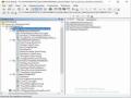
The above-mentioned materials processed to build a database, contain information on water source security, exploitation status, water resource planning, water resources; is stored in the geodatabase with the structure shown in Figure 3.1.
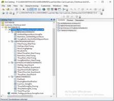
Figure 3.1: Structure of water resources database
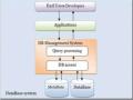
Water resources database in ArcGIS is shown:
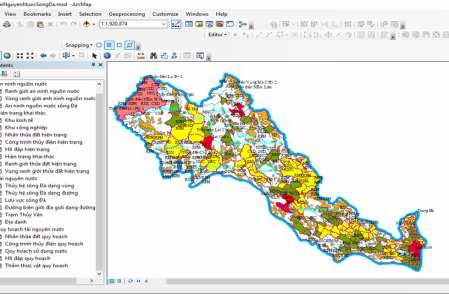
Figure 3.2: Water Resources Database (ArcGIS)
3.4. Comment on the level of water security in the Da river basin.
Based on the data of the Da River water security built into the national water database, we find that:
- Impacts on water sources in cities where population density is high, near industrial parks and economic zones in provinces with large hydroelectric power plants of Lai Chau, Dien Bien, Son La and Hoa Binh is in a state of alert, affecting severely on the mainstream of the river.
- In the study area of Da River mainstream, Hoa Binh province is considered as the weakest level of security. The level of water security is represented by the level of severity (level 1), impact area (level 2), area of impact (level 3), based on display file in Hoa Binh province, mainly level 1 and 2, the severity is in an alarming state, only a small area water is less affected. Therefore, Hoa Binh province should take specific measures to use water resources economically and effectively. Provide clear directions for use of water resources for hydropower development and agricultural development, avoiding waste. To raise the responsibility of individuals and
units and propagate to the people to well perform their tasks in order to contribute to ensuring the water source security for the region in particular and for the main river of Da river in general.
- In the remaining three provinces, Son La is the most safe water source with low impact, so it is necessary to maintain water source stability, contributing to the accumulation of water resources for the main river. Momentum, and timely discharge provide shortages of water to tributaries on the river mainstream. In Dien Bien and Lai Chau provinces, Dien Bien will need to pay more attention to the security of its water sources, as there is a large economic zone with a large concentration of trade in the future. The level of water security will increase significantly, so the province must have a policy to use water resources right now
- Significantly, it is not possible to assess the source of water in Lai Chau province, with a relatively large area located upstream of the mainstream of the Da River. Due to the abundant river system, abundant water supply from the upstream, however, it is impossible to assess the source of water, which will be one of the issues that need to be researched and developed. in the following research.
- Water security on the criterion of agricultural development: The vegetation cover on the main river of Da river is abundant, stretching all over the area of 6 provinces in the study area with good annual food supply. large. Therefore, the issue of water supply for agricultural development needs to be paid more attention, especially farming practices, to eliminate backward farming practices and to improve science and technology, so as to minimize the water quality as well as the deployment of more appropriate irrigation systems but still ensure the security of water sources on the mainstream of the river.
- Water resources security on the basis of hydropower development: With abundant water resources, the Da River main stream is a great potential for development of the power industry. Currently large hydroelectric power stations are located on the mainstream of the Da River, but based on the level of water security analyzed above, the development of this energy source must ensure the maximum pollution problem. Water resources and specific measures to build a continuous reservoir system to maximize the supply of water shortages in the rainy season.
4. Conclusion
Water security is becoming one of the major challenges for the future. Apart from objective factors such as climate change and environmental degradation, the negative impact of sustainable development policies and lack of vision is one of the main causes for this challenge.
Through the software ArcGIS10.2.2, the project has developed a database on water resources in the main stream of Da River, ensuring supply to managers, statistics and forecast of water resources with the scale of map 1 : 100,000. It is the first step to form a basic water resources database, thus contributing to the efficient use of water resources, ensuring sustainable development. An analysis of the results obtained in the study indicates that water flow and level of influence play a very important role in assessing the level of water security. Severely affected areas are concentrated in densely populated areas where large industrial clusters, economies of scale or thick vegetation cover. Meanwhile, the area of the area low impact concentrations are concentrated in sparsely populated areas, the economy has not developed much.
From the developed water resource database, we can assess the level of water source security in each province in the study area according to the development criteria of hydropower and agriculture. Consider the relationship
between population density, development level in industrial zones, economic zones and level of water source security; Water restoration and rehabilitation plays a very important role. The results obtained in the study are an important source of information for managers to make predictions and measures to minimize the damage caused by human activities to water.
5. Recommendations
The data used to build the water resources database on the mainstream of the Da River are not particularly well-known as the data on water sources, the existing data are only printed directly not used, so it takes much Time to edit, digitize and put the map on the correct rate by topic research. This also affects the completion time of the project, so it is only possible to build a database with moderate level of detail, further research to ensure the level of detail in the management and statistics and water security forecasts. Recommendations for the establishment of a 1: 25,000 water resources security database.
Keywords: Water resources database, water resources security, Da river.
MỞ ĐẦU
1. Tính cấp thiết của đề tài nghiên cứu
Hiện nay Việt Nam có 3450 sông, suối với chiều dài từ 10 km trở lên, các sông suối này nằm trong 108 lưu vực sông được phân bố và trải dài trên cả nước; nằm trong vùng khí hậu nhiệt đới gió mùa, Việt Nam được đánh giá là quốc gia có nguồn tài nguyên nước khá phong phú cả về lượng mưa, nguồn nước mặt trong các hệ thống sông hồ và nguồn nước dưới đất.
Tuy nhiên, nguồn tài nguyên nước đang phải đối mặt với nguy cơ khan hiếm trầm trọng do tình trạng ô nhiễm, suy thoái, và việc sử dụng nước không hợp lý của con người, đặc biệt là sự tác động mạnh mẽ của biến đổi khí hậu đến tài nguyên nước đang ngày càng rò rệt hơn. Thiên tai, bão lũ, hạn hán, xâm nhập mặn, ngập úng, nước biển dâng… ngày càng gia tăng về mức độ nghiêm trọng và phạm vi ảnh hưởng của nó. Do đó, việc khai thác quản lý và sử dụng tài nguyên nước có ý nghĩa quan trọng đối với con người và trở thành tiêu điểm được nhắc tới nhiều nhất. Để giải quyết vấn đề này, chúng ta cần phải xem xét đưa ra các giải pháp hợp lý để tổng hợp, phân tích, đánh giá mức độ phù hợp và sử dụng hợp lý nguồn tài nguyên quan trọng này.
Đã có nhiều đề tài nghiên cứu về tài nguyên nước, tuy nhiên chưa có một hệ thống cơ sở dữ liệu thống nhất để sử dụng cho các nghiên cứu khác nhau. Số liệu, thông tin liên quan về nguồn tài nguyên nước đang được lưu trữ dưới dạng hồ sơ, văn bản, lưu trữ dưới các khuôn dạng khác nhau và chưa được tổng hợp thống nhất giữa các ban ngành. Ngoài ra chưa có ứng dụng CSDL và công nghệ GIS nào để xây dựng hệ thống CSDL thống nhất trên toàn lưu vực sông Đà, do đó việc xây dựng lên một cơ sở dữ liệu tài nguyên nước là cần thiết để dễ dàng cho việc quản lý, tra cứu, tìm kiếm và đưa ra những dự
báo cần thiết về mức độ nước dùng cho mọi ngành nghề, mọi lĩnh vực một cách hợp lý và có khoa học nhất.
Hiện tại, việc quản lý tài nguyên nước trên dòng chính sông Đà đang phải đối mặt với việc đô thị hóa và sự phát triển nhanh chóng của công nghiệp, nó đã gây áp lực lên nhu cầu sử dụng của công nghiệp, dân sinh và phát triển thủy điện. Cùng vào đó là nhu cầu sử dụng nước cạnh tranh trực tiếp với ngành sản xuất nông nghiệp, những vấn đề liên quan đến sự gia tăng nguồn nước thải công nghiệp, nước thải sinh hoạt đổ trực tiếp ra sông suối không qua xử lý… Mặt khác, các mâu thuẫn liên quan đến việc phân phối tài nguyên nước trong lưu vực, vì thế việc xây dựng các hồ chứa lớn sẽ làm thay đổi sự thiếu hụt nước và gia tăng việc kiểm soát lũ trong mùa mưa. Mâu thuẫn tiềm tàng giữa tưới, cấp nước cho đô thị, phát triển thủy điện, giao thông thủy và môi trường ngày càng rò rệt, do vậy quản lý lưu vực sông để đảm bảo an ninh nguồn nước, cung cấp một cách chi tiết các dữ liệu về tài nguyên nước để thuận tiện cho công tác quản lý, dự báo nguồn nước cho lưu vực sông Đà đã trở thành vấn đề cấp thiết cần phải thực hiện.
Việc ứng dụng công nghệ thông tin để xây dựng cơ sở dữ liệu phục vụ công tác quản lý, quy hoạch tài nguyên nước nói chung và các tỉnh thành trên cả nước nói riêng của đề tài luận văn: “ Xây dựng cơ sở dữ liệu tài nguyên nước tỷ lệ 1:100.000 phục vụ đảm bảo an ninh nguồn nước trên dòng chính sông Đà ” là đi đúng hướng với phát triển của khoa học công nghệ hiện nay.
2. Mục tiêu nghiên cứu của đề tài
Xây dựng cơ sở dữ liệu phục vụ công tác quản lý tài nguyên nước trên dòng chính sông Đà tuân theo các tiêu chí kỹ thuật hiện hành của Bộ Tài nguyên và Môi trường, đáp ứng các mục tiêu của dự án tổng thể nhằm:
- Xây dựng cơ sở dữ liệu tài nguyên nước bằng công nghệ tin học, cụ thể