57. Viện nghiên cứu chiến lược và chính sách công nghê, viện khoa học Thủy lợi Miền nam (2009), Kết quả xây dựng bản đồ ngập lụt cho thành phố Đà Nẵng ứng vơi các kịch bản biến đổi khí hậu-nước biển dâng.
58. Nguyễn Việt (2006), Thiên tai tại Thừa Thiên Huế và các biện pháp phòng tránh tổng hợp.
59. Nguyễn Văn Viết (2009), Tài nguyên khí hậu nông nghiệp Việt Nam, NXB Nông nghiệp, Hà Nội.
60. Trịnh Việt (2010), Đánh giá rủi ro do lũ cho lưu vực sông Thạch Hãn tỉnh Quảng Trị, Luận văn Thạc sĩ, Trường Đại học Khoa hoc Tự Nhiên, ĐHQGHN.
61. Đặng Hùng Võ và Nguyễn Đức Khả (2007), Cơ sở địa chính, NXB Đại học Quốc gia Hà Nội.
62. Trần Thanh Xuân (2000), Lũ lụt và cách phòng chống, Nhà xuất bản Khoa học và Kỹ thuật, Hà Nội.
63. Nguyễn Thị Hải Yến (2013), Nghiên cứu tác động của quá trình công nghiệp hóa đến quản lý, sử dụng đất nông nghiệp và đời sống người dân huyện Quế Võ, tỉnh Bắc Ninh, Luận án tiến sĩ nông nghiệp, Trường Đại học Nông nghiệp Hà Nội (Hiện đã đổi tên thành Học Viên Nông nghiệp Việt Nam).
Tài liệu tiếng Anh
64. A. Paulo, Martins, D., Pereira, LS. (2016), "Influenceofprecipitationchangeson the SPI and related drought severity. An analysis using long-term data series", Water Resour. Manag. 30, pp. 1–21.
65. A. S. Islam, Bala. S. K and A. Haque (2009), "Flood Inundation Map of Bangladesh Using MODIS Surface Reflectance Data", International Conference on Water & Flood Management (ICWFM) , 80, pp. 245-256
Có thể bạn quan tâm!
-
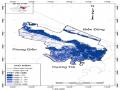
 Diện Tích Đất Nông Nghiệp Bị Hạn Hán Vụ Hè Thu Năm 2015 Theo Đơn Vị Hành Chính Tại Huyện Quảng Điền, Tỉnh Thừa Thiên Huế
 -
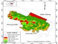 Sơ Đồ Dự Báo Đất Nông Nghiệp Bị Hạn Hán Vụ Hè Thu Đến Năm 2035 Tại Huyện Quảng Điền (Hình Ảnh Bản Đồ Được Thu Nhỏ Từ Tỷ Lệ 1:25.000)
 -
 Nghiên cứu ảnh hưởng của ngập lụt và hạn hán đến sử dụng đất nông nghiệp ở huyện Quảng Điền, tỉnh Thừa Thiên - Huế trong bối cảnh biến đổi khí hậu - 21
 -
 Địa Chỉ : Xã., Huyện Quảng Điền, Tỉnh Thừa Thiên Huế
 -
 Nghiên cứu ảnh hưởng của ngập lụt và hạn hán đến sử dụng đất nông nghiệp ở huyện Quảng Điền, tỉnh Thừa Thiên - Huế trong bối cảnh biến đổi khí hậu - 24
 -
 Nghiên cứu ảnh hưởng của ngập lụt và hạn hán đến sử dụng đất nông nghiệp ở huyện Quảng Điền, tỉnh Thừa Thiên - Huế trong bối cảnh biến đổi khí hậu - 25
Xem toàn bộ 203 trang tài liệu này.
66. Alexandru Nedelea, Laura Comanescu (2013), Mapping Flood vulnerability. Case study: Tecuci Town (Romania), University of Bucharest, Faculty of Geography, GeomorphologyPedology, Hydrology Dept.
67. AOSTAT (2004), FAO Statistic Database.

68. Asadi Zarch M. A. Bari A. H., Dastorani M. T., Kousari M. R., Safari Z. M. (2011), "The survey of climatic drought trend in Iran", Stoch Environ Res Risk Assess. Doi:10.1007/s00477-011-0491-7.
69. Antonio Di Gregorio J. M. Jansen Louisa (2004), "Obtaining Land-use information from a remotely sensed land cover map: results from a case study in Lebanon", Internationnal Journal of Applied Earth Observation and Geoinfomation, 5 (2), pp. 141.
70. Anthony J. Viera và Joanne M. Garrett (2005), "Understanding Interobserver Agreement: The Kappa Statistic", Family Medicine 2005, số 35, pp. 360-363.157
71. ByEna GasMez, Tereza Cavazos, Luis Mendoza, Application of ArcGIS tools for flood Risk Assessment. Centro de Investigation Cientifica y de Education Superior de Ensenada, B.C (CICESE), Mexico.
72. Beatriz da silveira Pinheiro (2003), "Agricultural Innovation and Social Inclusion, Global Hungerndex", International Food Policy Research Institute, Washington.
73. Bissonnette, V. L. (2007) “Statistical Tables.” Victor Bissonnette’s Home Page
.23 Mar.2004. Dept. Of Psychology, Berry College.
74. C. Shen, et al. (2008), "Characteristics of anomalous precipitation events over eastern China during the past five centuries", Climate Dynamics, 31 (4), pp. 463–476.
75. Chang Joo Kim, Min Jae Park, Joo Heon Lee (2013), "Analysis of climate change impacts on the spatial and prequency patterns of drought using a potential drought hazard mapping approach", International Journal of Climatology, Int. J. Climatol. 34, pp. 61-80.
76. D. Shankman, et al. (2006), "Flood frequency in China’s Poyang Lake Region: trends and teleconnections", International Journal of Climatology, 26, pp. 1255– 1266.
77. D.M. Konisky, Hughes,L., Kaylor, C.H. (2016), "Extreme weather event sand climate change concern", Clim. Chang. 134 (4), tr. 533–547.
78. D.R. Easterling (2000), "Climate extremes. Observations, modeling, and impacts", Science 289, pp. 2068–2074.
79. Dagmar Haase Sebastian Scheuer, Volker Meyer (2010), Exploring multicriteria flood vulnerability by integrating economic, social and ecological dimension of flood risk and coping capacity: from a starting point view towards an end point view of vulnerability, Nartural Hazards and Earth System Sciences, Springer.
80. Dong, Z., Wang, Z., Liu, D., Song, K., Li, L., Jia, M., & Ding, Z. , 2014. Mapping wetland areas using Landsat-derived NDVI and LSWI: A case study of West Songnen plain, Northeast China. Journal of the Indian Society of Remote Sensing, 42(3), 569–576.
81. Daniel, Wayne W. (1990). "Spearman rank correlation coefficient". Applied Nonparametric Statistics (2nd ed.). Boston: PWS-Kent. pp. 358–365.
82. Danilo Mollicone Susana Martínez (2012), "From Land Cover to Land Use: Amethodology to Assess Land Use from Remote Sensing Data", Remote Sensing, 4 (12), pp. 1024 – 1045
83. Engel B. A. and Johannsen C. J. Pantaleoni E. (2007), "Identifying agricultural flood damage using Landsat imagery", Precision Agriculture, 8(1–2), pp. 27–36.
84. F. Zhai, and J. Zhuang (2009), Agricultural Impact of Climate Change: A General Equilibrium Analysis with Special Reference to Southeast Asia, Asian Development Bank Institute Working Paper Series 131. Manila, the Philippines: Asian Development Bank.
85. F. Sarmadian H. R. Matinfar, S. K. Alavi Panah, R. J. Heck (2007), "Comparison of Object-oriented and Pixel-based Classification of Land use/Land Cover Types Based on Lansadsat7, Etm+ Spectal Bands (Case Study: Arid Region of Iran)", American-Eurasian J. Agric. & Environ., 2 (4), pp. 448 -456.
86. Gadiwala M. S. Khan M. A. (2013), "A study of drought over Sindh (Pakistan) Using Standardized precipitation Index (SPI) 1951 – 2010", Pakistan Journal of Meteorology 9 (18).
87. Gary Yoke Kenneth Strzepek, Jame Neumann and Brent Boehlert (2010), "Charactering changes in drought risk for the United States from climate change", Environmental Research, 5 (4), pp. 347–368.
88. H. Chen, Sun, J. (2015), "Changes indrought characteristics over China using the standardized precipitation evapotranspiration index", J. Clim. 28 (13), tr. 281– 299.
89. H. Schroll, Andersen J., Lund S. and Quang V. N. (2011), Climate change and development responses on agriculture in Quang Nam Province Vietnam, Workshop program Quang Binh Province 8-12 August 2011: Assessing the outcomes of the research activities achieved under P1-08VIE project.
90. H. Wang, Chen, Y., Xun, S. (2013), "Changes in daily climate extremes in the arid area of northwestern China", Theor. App. Clim. 112, pp. 15–28.
91. Hill G. Kenyon W., and Shannon P. (2008), "Scoping the role of agriculture in sustainable flood management", Land Use Policy, 25(3), pp. 351–360.
92. Hong Y. Khan S. I., Wang J., et al. (2011), "Satellite remote sensing and hydrologic modeling for flood inundation mapping in Lake Victoria basin: Implications for hydrologic prediction in ungauged basins", IEEE Transactions on Geoscience and Remote Sensing, 49(1), pp. 85–95.
93. Hossein Malekinezhad Mohammad Amin Asadi Zarch, Mohammad Hossein Mobin, Mohammad Taghi Dastorani, Mohammad Reza Kousari (2011), "Drought monitoring by reconnaissance drought index (rdi) in iran", Water Resour Manage. 25, pp. 3485–3504.
94. HZ. Pakhriazad Hasmadi I Mohd, MF. Shahrin (2009), "Evaluating supervised and unsupervised techniques for land cover mapping using remote sensing data", Malaysian Journal of Society and Space, 5 (1), pp. 1 – 10.
95. I. Douglas (2009), Climate change, flooding and food security in south Asia, Food Security, 1 (2), tr. 127–136.
96. IPCC (Intergovernmental Panel on Climate Change) (2007), Climate change 2007: The physical science basic. Contribution of working group I to the fourth assessment report of Intergovernmental Panel on climate change, Cambridge, UK: Cambridge University Press.
97. IPCC (Intergovernmental Panel on Climate Change) (2007), Fourth Assessment Report Synthesis Report.
98. J. G. and Brian Eric, R. S. (2013), Modeling Forest Mortality Caused by Drought Stress: Implications for Climate Change, Ecosystems 16: 60–74 DOI: 10.1007/s10021-012-9596-1.
99. J.P.M. and Brakenridge Syvitski, G.R. (2013), Causation and avoidance of catastrophic flooding along the Indus River, Pakistan.
100. Jason E. S. Benjamin I. C., Richard S., and Edwward R. C. (2013), "Pan- Continental Drought in North America over the last Millennium", Journal of Climate 2, pp. 383-397.
101. J. Chen, Gong, P., He, C.Y., Pu, R.L. and Shi, P.J. (2003), "Land-use/land-cover change detection using improved change-vector analysis", Photogrammetric Engineering and Remote Sensing, 69, pp. 369–379.
102. J. F. Mas Y. Gao (2008), "A comparision of the performance of pixel-based and object classification over images with various spatial resoulutions", pp. 1 - 6.
103. J. FMas Geo Yan, B. H. P. Maathuis, Shang Xiangmin, P. M. Van Dijk (2006), "Comparison of pixel-based and Object-oriented image Classification approaches
– a case study in a coal fire area, Wuda, Inner, Mongolia, China", International Journal of Remote sensing, 27, pp. 11- 18.
104. J. Imbernon (1999), "Pattern and development of land-use changes in the Kenyan highlands since the 1950s", Agriculture Ecosystems and Environment,, pp. 67– 73.
105. Jalal Behzadi (2013), "An evaluation of two drought indices, standard distribution and deciles in guilan Iran", Greener journal of social sciences ISSN: 2276-7800 3 (9), pp. 472-478.
106. Karlsen, S. R., Tolvanen, A., Kubin, E., Poikolainen, J., Høgda, K. A., Johansen, B., … Makarova, O. , 2008. MODIS-NDVI-based mapping of the length of the growing season in northern Fennoscandia. International Journal of Applied Earth Observation and Geoinformation, 10(3), 253–266.
107. K. G. Prasun K. P. Gaurav (2010), "Comparision of Advanced Pixel based (ANN and SVM) and Object orinted classification approaches using Lansat 7ETM data", International Journal of Engineering and Technology, pp. 245 – 251.
108. Li Lia Wei Sua Minjie Chena, Chao Zhanga, Anzhi Yuea, Haixia Lia (2009), "Comparison of pixel-based and Object-oriented Knowledge-based Classification Methods Using Spot5 Imagery", Information science and applications, 3 (6), pp. 447 – 459.
109. L.M. Bouwer, et al. (2007), "Confronting disaster losses", Science, 318, tr. 753.
110. Lu Liu, Hong, Yang; and Hocker, James E. (2011), Analyzing Past and Predicting Future Drought with Comprehensive Drought Indices for Arkansas-Red River Basin, Symposium on Data-Driven Approaches to Droughts, pp. 38-83.
111. Lu, S., Wu, B., Yan, N., Wang, H., 2011. Water body mapping method with HJ- 1A/B satellite imagery. Int. J. Appl. Earth Obs.Geoinf. 13 (3), 428–434.
112. McKee Thomas B., Nolan J. Doesken và John Kleist (1993), The relationship of drought frequency and duration to time scales, Eighth Conference on Applied Climatology, Anaheim, California
113. Major D. C. Aerts J., Bowman M. J., Dircke P. and Aris Marfai M. (2009), Connecting delta cities: coastal cities, flood risk management and adaptation to climate change.
114. M.M Mukaka (2012), Statistics corner: a guide to appropriate use of correlation coefficient, Malawi Medical Journal.
115. MRC. (2008), Preparing the Greater Mekong Subregion Flood and Drought Risk Management and Mitigation Project, Mekong River Commission, Vientiane Laos.
116. MRC. (2011), The Flood Management and Mitigation Program 2011–2015, Mekong River Commission, Phnom Penh, Cambodia.
117. Martín-Montero A. and Casterad M. A. Martínez-Casasnovas J. A. (2005), "Mapping multi-year cropping patterns in small irrigation districts from time- series analysis of Landsat TM images", European Journal of Agronomy, 23(2), pp. 159–169.
118. N. Kshirsagar, Shinde, R., and Mehta, S. (2006), "Floods in Mumbai: impact of public health service by hospital staff and medical students", Journal of Postgraduate Medicine, 52 (4), pp. 312.
119. N. Ranger, et al. (2011), "An assessment of the potential impact of climate change on flood risk in Mumbai", Climatic Change, 104, pp. 139–167.
120. Nakayama D. Hoque R., Matsuyama H. and Matsumoto J. (2011), “Flood monitoring, mapping and assessing capabilities using RADARSAT remote sensing, GIS and ground data for Bangladesh”, Journal of Natural Hazards, 57(2), tr. 525–548.
121. NDMC (2006), "What is drought".
122. Onyango O. A. (2014), "Analysis of Meteorological drought in North Eastern province of Kenya", Journal Earth science and climate change 5:219. Doi:10.4172/2157-7617.1000219.
123. Okamoto, K., & Fukuhara, M. ,1996. Estimation of paddy field area using the area ratio of categories in each mixel of Landsat TM. International Journal of Remote Sensing, 17(9), 1735–1749.
124. P. Vera, Lubos, T., Kožnarová, V., Martin, M. (2010), "Drought episodes in the Czech Republic and their potential effects in agriculture", Theor Appl Climatol Journal 99:373–388. DOI 10.1007/s00704-009-0148-3.
125. Patrick Scholz Monica Ionita, Silvia Mihaela Chelcea (2016), "Assessment of drought in Romania using the Standardized Precipitation Index", Journal of Natural Hazards, Vol 81 (3).
126. Peter H. G. (2012), China and Water, Chapter 5, The world’s Water 2008-2009.
127. Pilon P. J. (2004), Guidelines for reducing flood losses, New York, Naciones Unidas.
128. P. Mausel D. Lu, E. Brondízio, E. Moran (2004), "Change detection techniques", International Journal of Remote Sensing, 25 (12), tr. 2365 - 2401.
129. P.A. Burrough (1986), "Principles of Geographical Information Systems for land Resources Assessment", Clarendon, Oxford.
130. Paulm Mather Brandt Tso (2009), "Classification Methods for remotely Sensed Data", Second Edition, Taylor & Francis Group, LLC
131. Richard F. Conner (2007), Flood vulnerability index.
132. R. J. Heck A. Dehvari (2009), "Comparison of object based and pixel based infrared airborne image classification methods using DEM thematic layer", Journal of Geography and Regional Planning, 2, pp. 86 – 96
133. R. Walker (2003), "Mapping process to pattern in the landscape change of the Amazonian frontier", Annals of the Association of American Geographers, 93, pp. 376–398.
134. S. Dash, et al. (2007), "Some evidence of climate change in twentiethcentury India", Climatic Change, 85, pp. 299–321.
135. Sharma D. Mundetia N. (2014), "Analysis of rainfall and drought in Rajasthan State, India", Global NEST Journal 16, pp. 1-11.
136. Singh M. (2006), Identifying and assessing drought hazard and risk in Africa, Regional Conference on Insurance and Reinsurance for Natural Catastrophe Risk in Africa, Casablanca Morocco, pp. 37.
137. Stancalie G. at all Mateescu Elena (2012), "Drought Monitoring in Romania, Proceedings of the joint Workshop JRC/DMCSEE/Biotechnical faculty/Different approaches to drought monitoring towards EuroGEOSS interoperability model Ljubljana', 23rd – 25th November 2011, Towards EuroGEOSS interoperability modelin drought monitoring in SEE region, ISBN 978-961-6275-43-9, pp. 16-27.
138. Slovin M. B. and Sushka M. E. (1984), "A note on the evidence on alternative models of the banking firm. A cross section study of commercial loan rates", Journal of Banking and Finance, số 8(1), pp. 99-108. DOI: 10.1016/S0378- 4266(84)80027.
139. Schmid, John Jr. (December 1947). "The relationship between the coefficient of correlation and the angle included between regression lines". The Journal of Educational Research. 41 (4): 311–313.
140. Sunil Narumalani, Donald C. Rundquist, Jill Maeder, Stephen Payton, 1999. Đặc trưng mô hình và xu hướng của thảm thực vật đất ngập nước bằng cách sử dụng chỉ số thực vật NDVI.
141. T. Y. and Sergienko I. V. Ermolieva (2008), "Catastrophe risk management for sustainable development of regions under risks of natural disasters", Cybernetics and Systems Analysis, 44(3), pp. 405.
142. Tan H. Huang X., Zhou J., et al. (2008), "Flood hazard in Hunan province of China: an economic loss analysis", Natural Hazards, 47(1), pp. 65–73.
143. Tigkas D. Vangelis H., Tsakiris G. (2013), "The effect of pet method on reconnaissance drought index (rdi) calculation", Journal of Arid Environments. 88(2013), pp. 130-140.
144. Tolvanen A. Karlsen S. R., Kubin E., et al. (2008), "MODIS-NDVI-based mapping of the length of the growing season in northern Fennoscandia", International Journal of Applied Earth Observation and Geoinformation, 10(3), pp. 253–266.
145. UNDP. (2004), Reducing Disaster Risk: A Challenge for Development, UNDP, New York, USA.
146. UNFCC (2007), Impacts, vulnerabilities and adaptation in developing country.
147. Vangelis H. Tigkas D., Tsakiris G. (2014), "Drinc: A software for drought analysis based on drought indices", Earth Science Informatics.
148. Vijayaraghavan. C.,Thirumalaivasan, Dr. D.,Venkatesan Dr. R., (2012), Utilization of Remote sensing and GIS in Managing Disasters – A Review, International Journal of Scientific & Enginerring research, 3(1),1–8.
149. V. Karunakaran Jipsa Kurian (2012), "A Survey on Image Classification Methods", International Journal of Advanced Research in Electronics and Communication Engineering, 1 (4), pp. 69 – 72.
150. World Meteorological Organization (2012), Standardized precipitation index user guide, World Meteorological Organization Geneva.
151. Wang, Y., Zhong, C. S., Cui, W. H., & Lv, P., (2010), Flood inundation and disaster prediction based on DEM, Paper Presented at the Geoscience and Remote Sensing (IITA-grs), 2010 Second IITA International Conference on Geoscience and Remote Sensing.
152. Watts M.J. and Bohle H.G (1993), "The space of vulnerability: the causal structure of hunger and famine", Progress in Human Geography 17, pp. 43-67.
153. Wilhite D. A. (2000), Drought as a natural hazard: concepts and definitions: In: Wilhite D. A. Wilhite (ed.), Drought: A Global Assessment, Natural Hazards and Disasters Siries, Routledge Publishers, New York, pp.3-18.
154. White, D. C., & Lewis, M. M. , (2011). A new approach to monitoring spatial distribution and dynamics of wetlands and associated flows of Australian Great Artesian Basin springs using QuickBird satellite imagery. Journal of Hydrology, 408(1–2), 140–152.
155. Woodcock, C. E., Allen, R., Anderson, M., Belward, A., Bindschadler, R., Cohen, W., … Helmer, E. , 2008. Free access to Landsat imagery. Science, 320(5879), 1011.
156. World Meteorological Organization (2012), Standardized precipitation index user.
157. Wang, Y., Zhong, C. S., Cui, W. H., & Lv, P., (2010), Flood inundation and disaster prediction based on DEM, Paper Presented at the Geoscience and Remote Sensing (IITA-grs), 2010 Second IITA International Conference on Geoscience and Remote Sensing
158. W.; Yang Liu, J.; Zhao, J.; Yang, L. (2017), "A Novel Method of Unsupervised Change Detection Using Multi-Temporal PolSAR Images", Remote Sens. 9, pp. 1135.
159. Wu, W.Y., Shen, X.H., Zou, L.J., Lu, S.L., Zhang, G.F., 2008. An integrated method for water body detection and delineation using Landsat ETM+ data. Bull. Sci. Technol. 24, 252–259.
160. Wang, Y., 2004. Using Landsat 7 TM data acquired days after a flood event to delineate the maximum flood extent on a coastal floodplain. Int. J. Remote Sens. 25 (5), 959–974.
161. Xihua Yang, Xiaojin Xie, De Li Liu, Fei Ji, and Lin Wang (2015), “Spatial Interpolation of Daily Rainfall Data for Local Climate Impact Assessment over Greater Sydney Regio”, Hindawi Publishing Corporation, Advances in Meteorology, Article ID 563629, 12 pages, http://dx.doi.org/10.1155/2015/56 3629.
162. Yoshi Wada, Niko Wanders and H. A. J. Van Lanen (2015), "Global hydrological droughts in the 21st century under a changing hydrological regime", Earth Syst. Dynam., 6, pp. 1–15.
163. Yan Y. Zhao B., Guo H., He M., Gu Y. and Li B. (2009), "Monitoring rapid vegetation succession in estuarine wetland using time series MODIS-based indicators: an application in the Yangtze River Delta area", Ecological Indicators, 9(2), pp. 346–356.
164. Zbigniew W. Kundzewicz (2013), "Lessons about early warning systems. In: EEA (European Environment Agency), ed. Late lessons from early warnings: science, precaution, innovation. EEA Report no. 1/2013", Copenhagen: European Environment Agency, pp. 347–368.
165. Z.W. Kundzewicz, et al. (2012), "Flood risk in Europe setting the stage. In: Z.W. Kundzewicz, ed. Changes in flood risk in Europe", Wallingford: IAHS Press, tr. 11–26.
166. Zhangyu Dong, 2013.Mapping Wetland Areas Using Landsat-Derived NDVI and LSWI: A Case Study of West Songnen Plain, Northeast China.
167. Zhao, B., Yan, Y., Guo, H., He, M., Gu, Y., & Li, B. , 2009. Monitoring rapid vegetation succession in estuarine wetland using time series MODIS-based indicators: an application in the Yangtze River Delta area. Ecological Indicators, 9(2), 346–356.
168. Zhang, Y., Wang, C., Wu, J., Qi, J., & Salas, W. A. , 2009. Mapping paddy rice with multitemporal ALOS/PALSAR imagery in southeast China. International Journal of Remote Sensing, 30(23), 6301–6315
169. Zheng, T., & Wang, Y., (2006), Mapping flood extent using a simple DEM- Inundation model. The North Carolina Geographer, 15, 1–19