The terrain is very complex, strongly fragmented, with steep slopes. The average altitude is 600 - 700m above sea level. The province has 3 main mountain systems: the mountain system on the left bank of the Da River, the mountain system on the right bank of the Ma River and the mountain system between the Da River and the Ma River. Most of the mountain ranges and rivers in the province gradually decrease in the Northwest - Southeast direction. Over 97% of the natural area belongs to the Da River and Ma River basins. Interspersed between the mountain ranges are valleys. Cultivated land is often small and narrow, with steep slopes. Son La has 2 plateaus, Moc Chau and Na San - Son La is relatively flat, convenient for developing industrial crops, fruit trees and raising large livestock.
Located at the source of two large rivers: Da River and Ma River, Son La is not only a key protection area for the Northern Delta and the two largest hydroelectric projects in the country, but also a potential and advantageous area for developing raw material forests with a scale of over 200,000 hectares, providing raw materials for the forest product processing industry and paper and pulp production.
In addition to the potential for developing a number of industrial crops, fruit trees, raising grazing livestock, and developing raw material forests, Son La also has many advantages for developing many other types of plants and animals with high economic value such as mulberry, silkworms, coffee, tea, clean vegetables, flowers, ornamental plants, raising livestock, poultry and rare animals on an industrial scale. Every year, Son La harvests 180,000 - 200,000 tons of corn and soybeans - the main raw materials for the animal feed processing industry.
The development potential of agricultural and forestry products and goods as above is the premise for Son La to be able to develop industrial facilities for processing agricultural and forestry products such as processing tea, milk, coffee, silk, meat, paper, animal feed... to participate in the domestic and export markets.
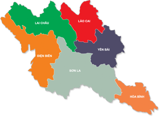
(Map: geographical location of Son La province, source: kiemlamsonla.gov.vn).
Climate, weather:
Son La is located in the tropical monsoon climate zone, with continental characteristics, influenced by terrain. The basic factors of Son La's climate are as follows:
- Cold and dry winter lasts from October to March of the following year.
- Summer is hot and humid, with lots of rain, starting from April to September.
- The average annual temperature is 21.5 0 C, the highest temperature is 37 0 C, the lowest temperature is 2 0 C. The average annual temperature is 7,550 0 C. The average number of sunny hours is 1,450 hours. The average number of sunny hours in summer is 7 hours/day. The Song Ma, Yen Chau, and Da River regions have temperatures 1 - 4 0 C higher than other regions.
- Average annual rainfall is 1,400mm. Average number of rainy days in a year is 118 days. Of which 80% of rainfall is concentrated in June, July, August, September. The area along the Da River has higher rainfall.
- Average humidity/year 80 - 82%.
- The prevailing winds are in two directions: the Northeast monsoon from October of the previous year to February of the following year and the Southwest monsoon from March to September. Especially from March to May, it is also affected by hot winds (Lao wind). The number of days affected by hot winds is 15 - 18 days/year. Son La is located deep inland and is protected by mountain ranges from being affected by storms, but there are still occasional local whirlwinds.
- Frost: From December to January of the following year, some areas in the province are affected by several frosts. In recent years, the frequency of frost in the province has tended to decrease.
The characteristics of Son La's climate and weather are high rainfall, high total temperature, and moderately cold winters, which are favorable conditions for a variety of crops from tropical to subtropical. The Moc Chau plateau has a cool temperate climate suitable for many types of cold-loving temperate crops. The advantage is that in the cold winter, temperate fruits and foods can be grown that are not available in the southern provinces.
With the weather and climate characteristics of Son La, it is very suitable for a variety of crops to grow. However, with the climate divided into two distinct rainy (May - October) and dry (November - April) seasons, it is difficult to develop agriculture in the dry season. There is a shortage of water for production, especially providing food for people. In the rainy season, the amount of rain is concentrated in addition to the large area of mountainous land and steep land, which also greatly affects the agricultural land resources of the province. Intercropping agricultural crops on the hills of Son Tra trees and fruit trees is a solution to solve the existing difficulties of Son La province.
3.1.1.2. Economic and social conditions:
The average population of the province in 2012 was 1,134.3 thousand people. The average population density was 79 people/km2 , but the distribution was uneven between cities.
urban and rural areas, between districts and cities. Most of the population lives in rural areas, with 975.9 thousand people (accounting for 86% of the province's population); the city population accounts for only 14%, much lower than the national average (national average 29.6%), showing that the level of urbanization, industrial and service development in Son La is still low.
Son La currently has 12 ethnic groups living together, including: Thai, Kinh, Mong, Muong, Dao, Kho Mu, La Ha, Xin Mun, Khang, Lao, Tay Hoa, integrating in production labor, cultural exchange, solidarity, creating cohesion, harmony, integration together to build Son La homeland to be more and more prosperous.
Table 3.1. Population of Son La province in the period 2007 - 2013
(Unit: 1000 people)
TT
District, City | 2007 | 2012 | 2013 | |
1 | Son La City | 90.0 | 97.2 | 98.4 |
2 | Quynh Nhai District | 57.2 | 59.8 | 60.8 |
3 | Thuan Chau District | 144.3 | 157.3 | 159.3 |
4 | Muong La District | 88.4 | 90.1 | 90.3 |
5 | Bac Yen District | 55.3 | 60.2 | 61.2 |
6 | Phu Yen District | 105.0 | 113.9 | 115.4 |
7 | Moc Chau District | 147.9 | 161.3 | 105.6 |
8 | Yen Chau District | 66.7 | 73.3 | 74.5 |
9 | Mai Son District | 134.6 | 146.6 | 149.1 |
10 | Song Ma District | 123.4 | 132.5 | 135.2 |
11 | Sop Cop District | 37.9 | 42.1 | 43.2 |
12 | Van Ho District | 57.5 | ||
Total province | 1,050.7 | 1,134.3 | 1,150.5 |
Maybe you are interested!
-
 Hoang Thanh Phuc (2009), "Research on Current Status and Solutions for Developing Scattered Forestry Planting in Thai Nguyen Province", Master's Thesis,
 -
 Studying the current status of rural environment and proposing some solutions to implement environmental criteria in new rural construction in San Thang commune, Lai Chau city, Lai Chau province - 2
 -
 Xa Ma Procession Festival in Hoang Chau Commune, Cat Hai District - current exploitation status and development solutions to serve local tourism - 11
 -
 Current Status of Using Technical Facilities and Infrastructure for Agricultural Tourism Development.
 -
 Current Status of Tax Management in Binh Thuan.
(Source: Son La Province Statistical Yearbook 2013)
With abundant labor resources, mainly agricultural production, the agricultural development of Son La province is very good. Applying Son Tra intercropping techniques to communes with suitable conditions and abundant labor resources will solve the surplus labor for ethnic minorities here. Besides, it contributes to providing food for people, improving the lives of ethnic minorities.
In recent years, the highland communes have been supported by many investment programs and projects such as Program 134, 135, phase II poverty reduction, Resolution 30a of the Government... People's lives have been somewhat improved. However, the situation of hunger and poverty still occurs, the poverty rate according to the new criteria still accounts for a large proportion due to the following reasons:
- The terrain is strongly fragmented, high mountains and deep ravines, flat land for little production, mainly land with large slopes. These are unfavorable conditions for agricultural production, the soil is eroded and infertile, and the circulation of goods is limited.
- Low level of education, the ability to apply scientific and technological advances in production is still inadequate, the long-standing farming practices of ethnic minorities are backward, production is self-sufficient, the habit of grazing livestock...
- Lack of investment capital for production due to low internal accumulation rate for reproduction, low credit loan capital, lack of priority investment focus for production and business. Investment capital from project programs is still low, scattered, and not very effective.
3.1.2. Current status of Hawthorn cultivation in Thuan Chau district
Hawthorn is a forestry tree with dual functions, both in developing forests and in harvesting fruits with stable productivity and output, with high economic value, each year yielding about 3,000 tons/year, estimated value of nearly 15 - 20 billion VND/year. Thanks to its outstanding advantages in several
In recent years, the hawthorn tree has been chosen as the key tree for economic development, hunger eradication and poverty reduction for people in highland communes.
Thanks to the implementation of capital sources from program 661, Resolution 30a of the government, Project KFW7 supported people in highland communes to plant 1,471.8 hectares of new forests of Son Tra trees, bringing the total existing Son Tra area to 2,876.6 hectares, of which: Natural forest 381 hectares, on average each highland household has 0.82 hectares.
Hawthorn trees grow and develop quite well, with a high survival rate and guaranteed density. Hawthorn areas planted 5 years or older have produced fruit. People's awareness of protecting and developing Hawthorn trees has been significantly improved. Households know how to weed, hoe, prune old branches and pests to create conditions for trees to grow. People pay attention to harvesting in the right season, and the need to plant new Hawthorn trees is increasing day by day. Not only in terms of developing new Hawthorn planting areas, households have organized to protect Hawthorn forests from nature and proactively increase the density of Hawthorn trees in natural forests.
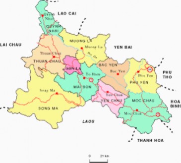
(Geographical map of Thuan Chau district, Son La province.
Source: kiemlamsonla.gov.vn)
Table 3.2. Area of Son Tra in Thuan Chau district
(Unit: ha)
STT
Capital/society | Total add | Area by year | ||||
2011 | 2012 | 2013 | 2014 | |||
TOTAL | 2,876.63 | 604.0 | 1,009.0 | 578.59 | 685.04 | |
1 | KFW7 Funding | 1,471.82 | 314 | 531.5 | 278.59 | 347.73 |
1.1 | Co Ma Commune | 168.40 | 0 | 168.4 | 0 | 0 |
1.2 | Ban Lam Commune | 227.40 | 227.4 | 0 | 0 | 0 |
1.3 | Nam Lau Commune | 224.09 | 0 | 60.3 | 50.61 | 113.18 |
1.4 | Muoi Noi Commune | 31.50 | 0 | 31.5 | 0 | 0 |
1.5 | Muong E Commune | 461.73 | 0 | 98.8 | 172.08 | 190.85 |
1.6 | Chieng Bom Commune | 358.70 | 86.6 | 172.5 | 55.90 | 43.70 |
2 | Capital 661 | 360.00 | 110 | 150 | 100 | 0 |
2.1 | Pilot Commune | 98.40 | 26 | 72.4 | 0 | 0 |
2.2 | Muong E Commune | 108.60 | 31 | 77.6 | 0 | 0 |
2.3 | Co Ma Commune | 95.00 | 40 | 0 | 55 | 0 |
2.4 | Ban Lam Commune | 45.00 | 0 | 0 | 45 | 0 |
2.5 | Long He Commune | 13.00 | 13 | 0 | 0 | 0 |
3 | District career capital | 864.81 | 0 | 327.5 | 200 | 337.31 |
3.1 | Pa Long Commune | 52.00 | 0 | 52.0 | - | - |
3.2 | Co Tong Commune | 28.00 | 0 | 28.0 | - | - |
3.3 | Long He Commune | 311.50 | 0 | 156.5 | - | 155.00 |
3.4 | Co Ma Commune | 172.31 | 0 | 35.0 | - | 137.31 |
3.5 | Nam Lau Commune | 37.00 | 0 | 7.0 | 30 | 0 |
3.6 | Chieng Bom Commune | 64.00 | 0 | 4.0 | 30 | 30.00 |
3.7 | Pilot Commune | 56.00 | 0 | 40.0 | 16 | 0 |
3.8 | E Tong Commune | 50.00 | 0 | 5.0 | 30 | 15.00 |
3.9 | Muong E Commune | 94.00 | 0 | 0 | 94 | 0 |
3.10 | Ban Lam Commune | 0.00 | 0 | 0 | 0 | 0 |
4 | Investment capital of enterprises | 180.00 | 180 | 0 | 0 | 0 |
4.1 | Long He Commune | 130.00 | 130 | 0 | 0 | 0 |
4.2 | Co Ma Commune | 50.00 | 50 | 0 | 0 | 0 |
Since 2011, Thuan Chau district has focused on investing in developing the Son Tra tree, because this tree is considered to have a dual advantage of meeting both protection and economic goals. Up to now, the total newly planted area is 1,234.4 hectares, with an investment value of 2,921,115 thousand VND. Of which:
+ Project 661 planted 531.8ha each year. ( in 2006 planted 192.33ha, in 2007 planted 39ha, in 2008 planted 140ha, in 2009 planted 159.75ha )
+ KFW7 project planted in 2010 is 100.4ha
+ Program 30a supports 1,001,506 seedlings ( supported in 2011)
222,530 trees; 2012 supported 298,176 trees; 2013 supported 480,800 trees ) equivalent to 665.94 hectares.
Table 3.3. Growth and development status of Hawthorn in some communes of Thuan Chau district
STT
Investigation unit (commune) | Year of planting | Survey area (ha) | D 00 (cm) | D 1.3 (cm) | D t | Hvn (m) | Number of years for fruit | Fruit yield (ton/ha) | Current density (trees/ha) | |
1 | Pilot | 2012 | 19 | 3.7 | 1.60 | 3.50 | 2 | 15.3 | 900 | |
2 | Muong E | 2011 | 3 | 2.6 | 1.37 | 3.00 | 1 | 12.6 | 1,400 | |
3 | Co Plating | 2012 | 14 | 4.9 | 1.76 | 4.40 | 0 | 1,360 | ||
4 | The Wrong Version | 2012 | 15 | 3.1 | 1.42 | 3.60 | 0 | 1,500 | ||
5 | Long He | 2010 | 10 | 0.8 | 0.50 | 1.20 | 0 | 1,323 | ||
6 | Nam Lau | 2011 | 17 | 0.6 | 0.40 | 0.80 | 0 | 1,450 | ||
7 | Chieng Bomb | 2012 | 16 | 0.5 | 0.30 | 0.62 | 0 | 1,600 | ||
8 | Pa Long | 2013 | 25 | 0.4 | 0.15 | 0.54 | 0 | 1,600 |
(Source: Report on the results of the inspection of agricultural and forestry production support policies from 2010-2014 by the People's Committee of Thuan Chau district)