the appearance of a series of geological faults, landslides and intense erosion, especially on the western slope adjacent to the Da River. [Nguyen Dinh Hoe, 2011]
This area was formed by the Indoxini orogeny 150 million years ago. Feralitization is a common process throughout the region, clearly shown by the color of the bottom in places with extremely strong erosion, low groundwater level with dark granular concretions. The main soil of Ba Vi mountain range is shale and sandstone with the following main soil types:
Yellow feralit soil is distributed at altitudes above 1000m, the thin soil layer has many rocks and exposed rocks distributed around Ngoc Hoa peak, common plants are green cypress, bamboo pine, rhododendron... Yellow-brown feralit soil develops on shale, sandstone, widely distributed and concentrated at altitudes of 500 - 1000m where there are exposed rocks: Common plants are beech, Re... Red-yellow feralit soil develops on shale, sandstone, mica schist and sedimentary rocks, distributed in slopes and low hills at altitudes below 500m, the soil layer is still thick but the humus ratio is low. Common plants are cogon grass, reed grass, tea, shrubs... as a result of slash-and-burn farming.
3.1.1.4. Climate characteristics 2
The general characteristics of Ba Vi's climate are determined by the following factors: Latitude, monsoon mechanism, terrain. Ba Vi area is located at latitude 21 0 North, affected by the monsoon mechanism. The combined effects of latitude and monsoon create a humid tropical climate with 2 distinct seasons. Winter is cold and dry, summer is hot and humid, heavy rain until March of the following year, from 400m and above there is no dry season.
The average annual temperature is 23.39 0 C, the coldest month is January (16.52 0 C), the coldest month is December (16.52 0 C).
The hottest month is July (28.69 0 C). The hot season is from April to November, the average temperature of the hottest season is 26.1 0 C, the hottest day of the season can reach 38.2 0 C. The cold season is from December to March of the following year, the average temperature of the cold season is 17.9 0 C, the lowest temperature can drop to 6.5 0 C.
Average annual humidity is 86.1 0 C. Average annual rainfall is 2587.2 mm.
The average annual evaporation is 759.5 mm, approximately 30% of the rainfall.
2 Quoted from Wikipedia.org website
Notable weather phenomena:
- Dry and hot westerly winds: every year in May, June and July, dry and hot westerly winds often occur, greatly affecting crops. On average, for all 3 months, there are about 15 to 18 hot and dry days with high temperatures exceeding 35 0 C and relative humidity falling below 50%.
- Frost: On cold winter nights, air temperature can drop to 0 0 C while surface temperature often drops below 0 0 C, frost appears, reducing crop productivity, especially seedlings in nurseries are susceptible to mass death.
3.1.2. Socio-economic characteristics
3.1.2.1. Social and population characteristics
The population in the study area is mainly Dao people and a small part is Kinh people. Ethnic groups do not live separately in each village, so there is cultural exchange and learning between ethnic groups. However, there are still typical customs of each ethnic group. Detailed data on ethnic composition in the commune are detailed in Table 3.1.
Table 3.1: Population of Ba Vi commune in 2010
Nation
Number of households | % | Population | % | |
Knife | 438 | 97.33 | 1948 | 97.4 |
Terrible | 12 | 2.67 | 52 | 2.6 |
Total | 450 | 100 | 2000 | 100 |
Maybe you are interested!
-
 Current Status of Land and Tourism Resources in Ba Vi National Park, Tam Dao, Ben En
 -
 Identify Rating Levels and Rating Scales
zt2i3t4l5ee
zt2a3gstourism,quan lan,quang ninh,ecology,ecotourism,minh chau,van don,geography,geographical basis,tourism development,science
zt2a3ge
zc2o3n4t5e6n7ts
of the islanders. Therefore, this indicator will be divided into two sub-indicators:
a1. Natural tourism attractiveness a2. Cultural tourism attractiveness
b. Tourist capacity
The two island communes in Quan Lan have different capacities to receive tourists. Minh Chau Commune is home to many standard hotels and resorts, attracting high-income domestic and international tourists. Meanwhile, Quan Lan Commune has many motels mainly built and operated by local people, so the scale and quality are not high, and will be suitable for ordinary tourists such as students.
c. Time of exploitation of Quan Lan Island Commune:
Quan Lan tourism is seasonal due to weather and climate conditions and festivals only take place on certain days of the year, specifically in spring. In Quan Lan commune, the period from April to June and from September to November is considered the best time to visit Quan Lan because the cultural tourism activities are mainly associated with festivals taking place during this time.
Minh Chau island commune:
Tourism exploitation time is all year round, because this is a place with a number of tourist attractions with diverse ecosystems such as Bai Tu Long National Park Research Center, Tram forest, Turtle Laying Beach, so besides coming to the beach for tourism and vacation in the summer, Minh Chau will attract research groups to come for tourism combined with research at other times of the year.
d. Sustainability
The sustainability of ecotourism sites in Quan Lan and Minh Chau communes depends on the sensitivity of the ecosystems to climate changes.
landscape. In general, these tourist destinations have a fairly high level of sustainability, because they are natural ecosystems, planned and protected. However, if a large number of tourists gather at certain times, it can exceed the carrying capacity and affect the sustainability of the environment (polluted beaches, damaged trees, animals moving away from their habitats, etc.), then the sustainability of the above ecosystems (natural ecosystems, human ecosystems) will also be affected and become less sustainable.
e. Location and accessibility
Both island communes have ports to take tourists to visit from Van Don wharf:
- Quan Lan – Van Don traffic route:
Phuc Thinh – Viet Anh high-speed boat and Quang Minh high-speed boat, depart at 8am and 2pm from Van Don to Quan Lan, and at 7am and 1pm from Quan Lan to Van Don. There are also wooden boats departing at 7am and 1pm.
- Van Don - Minh Chau traffic route:
Chung Huong high-speed train, Minh Chau train, morning 7:30 and afternoon 13:30 from Van Don to Minh Chau, morning 6:30 and afternoon 13:00 from Minh Chau to Van Don.
f. Infrastructure
Despite receiving investment attention, the issue of infrastructure and technical facilities for tourism on Quan Lan Island is still an issue that needs to be resolved because it has a direct impact on the implementation of ecotourism activities. The minimum conditions for serving tourists such as accommodation, electricity, water, communication, especially medical services, and security work need to be given top priority. Ecotourism spots in Minh Chau commune are assessed to have better infrastructure and technical facilities for tourism because there are quite complete and synchronous conditions for serving tourists, meeting many needs of domestic and foreign tourists.
3.2.1.4. Determine assessment levels and assessment scales
Corresponding to the levels of each criterion, the index is the score of those levels in the order of 4, 3, 2, 1 decreasing according to the standard of each level: very attractive (4), attractive (3), average (2), less attractive (1).
3.2.1.5. Determining the coefficients of the criteria
For the assessment of DLST in the two communes of Quan Lan and Minh Chau islands, the students added evaluation coefficients to show the importance of the criteria and indicators as follows:
Coefficient 3 with criteria: Attractiveness, Exploitation time. These are the 2 most important criteria for attracting tourists to tourism in general and eco-tourism in particular, so they have the highest coefficient.
Coefficient 2 with criteria: Capacity, Infrastructure, Location and accessibility . Because the assessment area is an island commune of Van Don district, the above criteria are selected by the author with appropriate coefficients at the average level.
Coefficient 1 with criteria: Sustainability. Quan Lan has natural and human-made ecotourism sites, with high biodiversity and little impact from local human factors. Most of the ecotourism sites are still wild, so they are highly sustainable.
3.2.1.6. Results of DLST assessment on Quan Lan island
a. Assessment of the potential for natural tourism development
For Minh Chau commune:
+ Natural tourism attractiveness is determined to be very attractive (4 points) and the most important coefficient (coefficient 3), so the score of the Attractiveness criterion is 4 x 3 = 12.
+ Capacity is determined as average (2 points) and the coefficient is quite important (coefficient 2), then the score of Capacity criterion is 2 x 2 = 4.
+ Exploitation time is long (4 points), the most important coefficient (coefficient 3) so the score of the Exploitation time criterion is 4 x 3 = 12.
+ Sustainability is determined as sustainable (4 points), the important coefficient is the average coefficient (coefficient 1), so the score of the Sustainability criterion is 4 x 1 = 4 points
+ Location and accessibility are determined to be quite favorable (2 points), the coefficient is quite important (coefficient 2), the criterion score is 2 x 2 = 4 points.
+ Infrastructure is assessed as good (3 points), the coefficient is quite important (coefficient 2), then the score of the Infrastructure criterion is 3 x 2 = 6 points.
The total score for evaluating DLST in Minh Chau commune according to 6 evaluation criteria is determined as: 12 + 4 + 12 + 4 + 4 + 6 = 42 points
Similar assessment for Quan Lan commune, we have the following table:
Table 3.3: Assessment of the potential for natural ecotourism development in Quan Lan and Minh Chau communes
Attractiveness of self-tourismof course
Capacity
Mining time
Sustainability
Location and accessibility
Infrastructure
Result
Point
DarkMulti
Point
DarkMulti
Point
DarkMulti
Point
DarkMulti
Point
DarkMulti
Point
DarkMulti
CommuneMinh Chau
12
12
4
8
12
12
4
4
4
8
6
8
42/52
Quan CommuneLan
6
12
6
8
9
12
4
4
4
8
4
8
33/52
b. Assessment of the potential for humanistic tourism development
For Quan Lan commune:
+ The attractiveness of human tourism is determined to be very attractive (4 points) and the most important coefficient (coefficient 3), so the score of the Attractiveness criterion is 4 x 3 = 12.
+ Capacity is determined to be large (3 points) and the coefficient is quite important (coefficient 2), then the score of the Capacity criterion is 3 x 2 = 6.
+ Mining time is average (3 points), the most important coefficient (coefficient 3) so the score of the Mining time criterion is 3 x 3 = 9.
+ Sustainability is determined as sustainable (4 points), the important coefficient is the average coefficient (coefficient 1), so the score of the Sustainability criterion is 4 x 1 = 4 points.
+ Location and accessibility are determined to be quite favorable (2 points), the coefficient is quite important (coefficient 2), the criterion score is 2 x 2 = 4 points.
+ Infrastructure is rated as average (2 points), the coefficient is quite important (coefficient 2), then the score of the Infrastructure criterion is 2 x 2 = 4 points.
The total score for evaluating DLST in Quan Lan commune according to 6 evaluation criteria is determined as: 12 + 6 + 6 + 4 + 4 + 4 = 36 points.
Similar assessment with Minh Chau commune we have the following table:
Table 3.4: Assessment of the potential for developing humanistic eco-tourism in Quan Lan and Minh Chau communes
Attractiveness of human tourismliterature
Capacity
Mining time
Sustainability
Location and accessibility
Infrastructure
Result
Point
DarkMulti
Point
DarkMulti
Point
DarkMulti
Point
DarkMulti
Point
DarkMulti
Point
DarkMulti
Quan CommuneLan
12
12
6
8
9
12
4
4
4
8
4
8
39/52
Minh CommuneChau
6
12
4
8
12
12
4
4
4
8
6
8
36/52
Basically, both Minh Chau and Quan Lan localities have quite favorable conditions for developing ecotourism. However, Quan Lan commune has more advantages to develop ecotourism in a humanistic direction, because this is an area with many famous historical relics such as Quan Lan Communal House, Quan Lan Pagoda, Temple worshiping the hero Tran Khanh Du, ... along with local festivals held annually such as the wind praying ceremony (March 15), Quan Lan festival (June 10-19); due to its location near the port and long exploitation time, the beaches in Quan Lan commune (especially Quan Lan beach) are no longer hygienic and clean to ensure the needs of tourists coming to relax and swim; this is also an area with many beautiful landscapes such as Got Beo wind pass, Ong Phong head, Voi Voi cave, but the ability to access these places is still very limited (dirt hill road, lots of gravel and rocks), especially during rainy and windy times; In addition, other natural resources such as mangrove forests and sea worms have not been really exploited for tourism purposes and ecotourism development. On the contrary, Minh Chau commune has more advantages in developing ecotourism in the direction of natural tourism, this is an area with diverse ecosystems such as at Rua De Beach, Bai Tu Long National Park Conservation Center...; Minh Chau beach is highly appreciated for its natural beauty and cleanliness, ranked in the top ten most beautiful beaches in Vietnam; Minh Chau commune is also home to Tram forest with a large area and a purity of up to 90%, suitable for building bridges through the forest (a very effective type of natural ecotourism currently applied by many countries) for tourists to sightsee, as well as for the purpose of studying and researching.
Figure 3.1: Thenmala Forest Bridge (India) Source: https://www.thenmalaecotourism.com/(August 21, 2019)
3.2.2. Using SWOT matrix to evaluate Quan Lan island tourism
General assessment of current tourism activities of Quan Lan island is shown through the following SWOT matrix:
Table 3.5: SWOT matrix evaluating tourism activities on Quan Lan island
Internal agent
Strengths- There is a lot of potential for tourism development, especially natural ecotourism and humanistic ecotourism.- The unskilled labor force is relatively abundant.- resource environmentunpolluted, still
Weaknesses- Poorly developed infrastructure, especially traffic routes to tourist destinations on the island.- The team of professional staff is still weak.- Tourism products in general
quite wild, originalintact
general and DLST in particularalone is monotonous.
External agents
Opportunity- Tourism is a key industry in the socio-economic development strategy of the province and Van Don economic zone.- Quan Lan was selected as a pilot area for eco-tourism development within the framework of the green growth project between Quang Ninh province and the Japanese organization JICA.- The flow of tourists and especially ecotourism in the world tends toincreasing
Challenge- Weather and climate change abnormally.- Competition in tourism products is increasingly fierce, especially with other localities in the province such as Ha Long, Mong Cai...- Awareness of tourists, especially domestic tourists, about ecotourism and nature conservation is not high.
Through summary analysis using SWOT matrix we see that:
To exploit strengths and take advantage of opportunities, it is necessary to:
- Diversify products and service types (build more tourism routes aimed at specific needs of tourists: experiential tourism immersed in nature, spiritual cultural tourism...)
- Effective exploitation of resources and differentiated products (natural resources and human resources)
div.maincontent .p { color: black; font-family:"Times New Roman", serif; font-style: normal; font-weight: normal; text-decoration: none; font-size: 14pt; margin:0pt; } div.maincontent p { color: black; font-family:"Times New Roman", serif; font-style: normal; font-weight: normal; text-decoration: none; font-size: 14pt; margin:0pt; } div.maincontent .s1 { color: black; font-family:"Times New Roman", serif; font-style: normal; font-weight: normal; text-decoration: none; font-size: 13pt; } div.maincontent .s2 { color: black; font-family:"Times New Roman", serif; font-style: normal; font-weight: normal; text-decoration: none; font-size: 13pt; } div.maincontent .s3 { color: #0D0D0D; font-family:"Times New Roman", serif; font-style: normal; font-weight: bold; text-decoration: none; font-size: 14pt; } div.maincontent .s4 { color: black; font-family:"Times New Roman", serif; font-style: italic; font-weight: normal; text-decoration: none; font-size: 14pt; } div.maincontent .s5 { color: black; font-family:"Times New Roman", serif; font-style: italic; font-weight: bold; text-decoration: none; font-size: 14pt; } div.maincontent .s6 { color: black; font-family:"Times New Roman", serif; font-style: italic; font-weight: normal; text-decoration: none; font-size: 14pt; vertical-align: -3pt; } div.maincontent .s7 { color: black; font-family:"Times New Roman", serif; font-style: italic; font-weight: normal; text-decoration: none; font-size: 14pt; vertical-align: -2pt; } div.maincontent .s8 { color: black; font-family:"Times New Roman", serif; font-style: italic; font-weight: normal; text-decoration: none; font-size: 14pt; vertical-align: -1pt; } div.maincontent .s9 { color: black; font-family:"Times New Roman", serif; font-style: normal; font-weight: normal; text-decoration: none; font-size: 14pt; } div.maincontent .s10 { color: black; font-family:"Times New Roman", serif; font-style: normal; font-weight: bold; text-decoration: none; font-size: 14pt; } div.maincontent .s11 { color: black; font-family:"Times New Roman", serif; font-style: normal; font-weight: normal; text-decoration: none; font-size: 14pt; } div.maincontent .s12 { color: black; font-family:Symbol, serif; font-style: normal; font-weight: normal; text-decoration: none; font-size: 14pt; } div.maincontent .s13 { color: black; font-family:Wingdings; font-style: normal; font-weight: normal; text-decoration: none; font-size: 14pt; } div.maincontent .s14 { color: black; font-family:"Times New Roman", serif; font-style: normal; font-weight: normal; text-decoration: none; font-size: 9pt; vertical-align: 5pt; } div.maincontent .s15 { color: black; font-family:"Times New Roman", serif; font-style: normal; font-weight: normal; text-decoration: none; font-size: 9pt; vertical-align: 5pt; } div.maincontent .s16 { color: black; font-family:Cambria, serif; font-style: italic; font-weight: normal; text-decoration: none; font-size: 14pt; } div.maincontent .s17 { color: #080808; font-family:"Times New Roman", serif; font-style: normal; font-weight: bold; text-decoration: none; font-size: 14pt; } div.maincontent .s18 { color: #080808; font-family:"Times New Roman", serif; font-style: normal; font-weight: normal; text-decoration: none; font-size: 14pt; } div.maincontent .s19 { color: black; font-family:"Times New Roman", serif; font-style: normal; font-weight: normal; text-decoration: none; font-size: 11pt; } div.maincontent .s20 { color: black; font-family:"Times New Roman", serif; font-style: normal; font-weight: normal; text-decoration: none; font-size: 10pt; } div.maincontent .s21 { color: black; font-family:"Times New Roman", serif; font-style: normal; font-weight: bold; text-decoration: none; font-size: 11pt; } div.maincontent .s22 { color: black; font-family:"Times New Roman", serif; font-style: normal; font-weight: normal; text-decoration: none; font-size: 11pt; } div.maincontent .s23 { color: black; font-family:"Times New Roman", serif; font-style: italic; font-weight: normal; text-decoration: none; font-size: 14pt; } div.maincontent .s24 { color: #212121; font-family:"Times New Roman", serif; font-style: normal; font-weight: normal; tex
Identify Rating Levels and Rating Scales
zt2i3t4l5ee
zt2a3gstourism,quan lan,quang ninh,ecology,ecotourism,minh chau,van don,geography,geographical basis,tourism development,science
zt2a3ge
zc2o3n4t5e6n7ts
of the islanders. Therefore, this indicator will be divided into two sub-indicators:
a1. Natural tourism attractiveness a2. Cultural tourism attractiveness
b. Tourist capacity
The two island communes in Quan Lan have different capacities to receive tourists. Minh Chau Commune is home to many standard hotels and resorts, attracting high-income domestic and international tourists. Meanwhile, Quan Lan Commune has many motels mainly built and operated by local people, so the scale and quality are not high, and will be suitable for ordinary tourists such as students.
c. Time of exploitation of Quan Lan Island Commune:
Quan Lan tourism is seasonal due to weather and climate conditions and festivals only take place on certain days of the year, specifically in spring. In Quan Lan commune, the period from April to June and from September to November is considered the best time to visit Quan Lan because the cultural tourism activities are mainly associated with festivals taking place during this time.
Minh Chau island commune:
Tourism exploitation time is all year round, because this is a place with a number of tourist attractions with diverse ecosystems such as Bai Tu Long National Park Research Center, Tram forest, Turtle Laying Beach, so besides coming to the beach for tourism and vacation in the summer, Minh Chau will attract research groups to come for tourism combined with research at other times of the year.
d. Sustainability
The sustainability of ecotourism sites in Quan Lan and Minh Chau communes depends on the sensitivity of the ecosystems to climate changes.
landscape. In general, these tourist destinations have a fairly high level of sustainability, because they are natural ecosystems, planned and protected. However, if a large number of tourists gather at certain times, it can exceed the carrying capacity and affect the sustainability of the environment (polluted beaches, damaged trees, animals moving away from their habitats, etc.), then the sustainability of the above ecosystems (natural ecosystems, human ecosystems) will also be affected and become less sustainable.
e. Location and accessibility
Both island communes have ports to take tourists to visit from Van Don wharf:
- Quan Lan – Van Don traffic route:
Phuc Thinh – Viet Anh high-speed boat and Quang Minh high-speed boat, depart at 8am and 2pm from Van Don to Quan Lan, and at 7am and 1pm from Quan Lan to Van Don. There are also wooden boats departing at 7am and 1pm.
- Van Don - Minh Chau traffic route:
Chung Huong high-speed train, Minh Chau train, morning 7:30 and afternoon 13:30 from Van Don to Minh Chau, morning 6:30 and afternoon 13:00 from Minh Chau to Van Don.
f. Infrastructure
Despite receiving investment attention, the issue of infrastructure and technical facilities for tourism on Quan Lan Island is still an issue that needs to be resolved because it has a direct impact on the implementation of ecotourism activities. The minimum conditions for serving tourists such as accommodation, electricity, water, communication, especially medical services, and security work need to be given top priority. Ecotourism spots in Minh Chau commune are assessed to have better infrastructure and technical facilities for tourism because there are quite complete and synchronous conditions for serving tourists, meeting many needs of domestic and foreign tourists.
3.2.1.4. Determine assessment levels and assessment scales
Corresponding to the levels of each criterion, the index is the score of those levels in the order of 4, 3, 2, 1 decreasing according to the standard of each level: very attractive (4), attractive (3), average (2), less attractive (1).
3.2.1.5. Determining the coefficients of the criteria
For the assessment of DLST in the two communes of Quan Lan and Minh Chau islands, the students added evaluation coefficients to show the importance of the criteria and indicators as follows:
Coefficient 3 with criteria: Attractiveness, Exploitation time. These are the 2 most important criteria for attracting tourists to tourism in general and eco-tourism in particular, so they have the highest coefficient.
Coefficient 2 with criteria: Capacity, Infrastructure, Location and accessibility . Because the assessment area is an island commune of Van Don district, the above criteria are selected by the author with appropriate coefficients at the average level.
Coefficient 1 with criteria: Sustainability. Quan Lan has natural and human-made ecotourism sites, with high biodiversity and little impact from local human factors. Most of the ecotourism sites are still wild, so they are highly sustainable.
3.2.1.6. Results of DLST assessment on Quan Lan island
a. Assessment of the potential for natural tourism development
For Minh Chau commune:
+ Natural tourism attractiveness is determined to be very attractive (4 points) and the most important coefficient (coefficient 3), so the score of the Attractiveness criterion is 4 x 3 = 12.
+ Capacity is determined as average (2 points) and the coefficient is quite important (coefficient 2), then the score of Capacity criterion is 2 x 2 = 4.
+ Exploitation time is long (4 points), the most important coefficient (coefficient 3) so the score of the Exploitation time criterion is 4 x 3 = 12.
+ Sustainability is determined as sustainable (4 points), the important coefficient is the average coefficient (coefficient 1), so the score of the Sustainability criterion is 4 x 1 = 4 points
+ Location and accessibility are determined to be quite favorable (2 points), the coefficient is quite important (coefficient 2), the criterion score is 2 x 2 = 4 points.
+ Infrastructure is assessed as good (3 points), the coefficient is quite important (coefficient 2), then the score of the Infrastructure criterion is 3 x 2 = 6 points.
The total score for evaluating DLST in Minh Chau commune according to 6 evaluation criteria is determined as: 12 + 4 + 12 + 4 + 4 + 6 = 42 points
Similar assessment for Quan Lan commune, we have the following table:
Table 3.3: Assessment of the potential for natural ecotourism development in Quan Lan and Minh Chau communes
Attractiveness of self-tourismof course
Capacity
Mining time
Sustainability
Location and accessibility
Infrastructure
Result
Point
DarkMulti
Point
DarkMulti
Point
DarkMulti
Point
DarkMulti
Point
DarkMulti
Point
DarkMulti
CommuneMinh Chau
12
12
4
8
12
12
4
4
4
8
6
8
42/52
Quan CommuneLan
6
12
6
8
9
12
4
4
4
8
4
8
33/52
b. Assessment of the potential for humanistic tourism development
For Quan Lan commune:
+ The attractiveness of human tourism is determined to be very attractive (4 points) and the most important coefficient (coefficient 3), so the score of the Attractiveness criterion is 4 x 3 = 12.
+ Capacity is determined to be large (3 points) and the coefficient is quite important (coefficient 2), then the score of the Capacity criterion is 3 x 2 = 6.
+ Mining time is average (3 points), the most important coefficient (coefficient 3) so the score of the Mining time criterion is 3 x 3 = 9.
+ Sustainability is determined as sustainable (4 points), the important coefficient is the average coefficient (coefficient 1), so the score of the Sustainability criterion is 4 x 1 = 4 points.
+ Location and accessibility are determined to be quite favorable (2 points), the coefficient is quite important (coefficient 2), the criterion score is 2 x 2 = 4 points.
+ Infrastructure is rated as average (2 points), the coefficient is quite important (coefficient 2), then the score of the Infrastructure criterion is 2 x 2 = 4 points.
The total score for evaluating DLST in Quan Lan commune according to 6 evaluation criteria is determined as: 12 + 6 + 6 + 4 + 4 + 4 = 36 points.
Similar assessment with Minh Chau commune we have the following table:
Table 3.4: Assessment of the potential for developing humanistic eco-tourism in Quan Lan and Minh Chau communes
Attractiveness of human tourismliterature
Capacity
Mining time
Sustainability
Location and accessibility
Infrastructure
Result
Point
DarkMulti
Point
DarkMulti
Point
DarkMulti
Point
DarkMulti
Point
DarkMulti
Point
DarkMulti
Quan CommuneLan
12
12
6
8
9
12
4
4
4
8
4
8
39/52
Minh CommuneChau
6
12
4
8
12
12
4
4
4
8
6
8
36/52
Basically, both Minh Chau and Quan Lan localities have quite favorable conditions for developing ecotourism. However, Quan Lan commune has more advantages to develop ecotourism in a humanistic direction, because this is an area with many famous historical relics such as Quan Lan Communal House, Quan Lan Pagoda, Temple worshiping the hero Tran Khanh Du, ... along with local festivals held annually such as the wind praying ceremony (March 15), Quan Lan festival (June 10-19); due to its location near the port and long exploitation time, the beaches in Quan Lan commune (especially Quan Lan beach) are no longer hygienic and clean to ensure the needs of tourists coming to relax and swim; this is also an area with many beautiful landscapes such as Got Beo wind pass, Ong Phong head, Voi Voi cave, but the ability to access these places is still very limited (dirt hill road, lots of gravel and rocks), especially during rainy and windy times; In addition, other natural resources such as mangrove forests and sea worms have not been really exploited for tourism purposes and ecotourism development. On the contrary, Minh Chau commune has more advantages in developing ecotourism in the direction of natural tourism, this is an area with diverse ecosystems such as at Rua De Beach, Bai Tu Long National Park Conservation Center...; Minh Chau beach is highly appreciated for its natural beauty and cleanliness, ranked in the top ten most beautiful beaches in Vietnam; Minh Chau commune is also home to Tram forest with a large area and a purity of up to 90%, suitable for building bridges through the forest (a very effective type of natural ecotourism currently applied by many countries) for tourists to sightsee, as well as for the purpose of studying and researching.
Figure 3.1: Thenmala Forest Bridge (India) Source: https://www.thenmalaecotourism.com/(August 21, 2019)
3.2.2. Using SWOT matrix to evaluate Quan Lan island tourism
General assessment of current tourism activities of Quan Lan island is shown through the following SWOT matrix:
Table 3.5: SWOT matrix evaluating tourism activities on Quan Lan island
Internal agent
Strengths- There is a lot of potential for tourism development, especially natural ecotourism and humanistic ecotourism.- The unskilled labor force is relatively abundant.- resource environmentunpolluted, still
Weaknesses- Poorly developed infrastructure, especially traffic routes to tourist destinations on the island.- The team of professional staff is still weak.- Tourism products in general
quite wild, originalintact
general and DLST in particularalone is monotonous.
External agents
Opportunity- Tourism is a key industry in the socio-economic development strategy of the province and Van Don economic zone.- Quan Lan was selected as a pilot area for eco-tourism development within the framework of the green growth project between Quang Ninh province and the Japanese organization JICA.- The flow of tourists and especially ecotourism in the world tends toincreasing
Challenge- Weather and climate change abnormally.- Competition in tourism products is increasingly fierce, especially with other localities in the province such as Ha Long, Mong Cai...- Awareness of tourists, especially domestic tourists, about ecotourism and nature conservation is not high.
Through summary analysis using SWOT matrix we see that:
To exploit strengths and take advantage of opportunities, it is necessary to:
- Diversify products and service types (build more tourism routes aimed at specific needs of tourists: experiential tourism immersed in nature, spiritual cultural tourism...)
- Effective exploitation of resources and differentiated products (natural resources and human resources)
div.maincontent .p { color: black; font-family:"Times New Roman", serif; font-style: normal; font-weight: normal; text-decoration: none; font-size: 14pt; margin:0pt; } div.maincontent p { color: black; font-family:"Times New Roman", serif; font-style: normal; font-weight: normal; text-decoration: none; font-size: 14pt; margin:0pt; } div.maincontent .s1 { color: black; font-family:"Times New Roman", serif; font-style: normal; font-weight: normal; text-decoration: none; font-size: 13pt; } div.maincontent .s2 { color: black; font-family:"Times New Roman", serif; font-style: normal; font-weight: normal; text-decoration: none; font-size: 13pt; } div.maincontent .s3 { color: #0D0D0D; font-family:"Times New Roman", serif; font-style: normal; font-weight: bold; text-decoration: none; font-size: 14pt; } div.maincontent .s4 { color: black; font-family:"Times New Roman", serif; font-style: italic; font-weight: normal; text-decoration: none; font-size: 14pt; } div.maincontent .s5 { color: black; font-family:"Times New Roman", serif; font-style: italic; font-weight: bold; text-decoration: none; font-size: 14pt; } div.maincontent .s6 { color: black; font-family:"Times New Roman", serif; font-style: italic; font-weight: normal; text-decoration: none; font-size: 14pt; vertical-align: -3pt; } div.maincontent .s7 { color: black; font-family:"Times New Roman", serif; font-style: italic; font-weight: normal; text-decoration: none; font-size: 14pt; vertical-align: -2pt; } div.maincontent .s8 { color: black; font-family:"Times New Roman", serif; font-style: italic; font-weight: normal; text-decoration: none; font-size: 14pt; vertical-align: -1pt; } div.maincontent .s9 { color: black; font-family:"Times New Roman", serif; font-style: normal; font-weight: normal; text-decoration: none; font-size: 14pt; } div.maincontent .s10 { color: black; font-family:"Times New Roman", serif; font-style: normal; font-weight: bold; text-decoration: none; font-size: 14pt; } div.maincontent .s11 { color: black; font-family:"Times New Roman", serif; font-style: normal; font-weight: normal; text-decoration: none; font-size: 14pt; } div.maincontent .s12 { color: black; font-family:Symbol, serif; font-style: normal; font-weight: normal; text-decoration: none; font-size: 14pt; } div.maincontent .s13 { color: black; font-family:Wingdings; font-style: normal; font-weight: normal; text-decoration: none; font-size: 14pt; } div.maincontent .s14 { color: black; font-family:"Times New Roman", serif; font-style: normal; font-weight: normal; text-decoration: none; font-size: 9pt; vertical-align: 5pt; } div.maincontent .s15 { color: black; font-family:"Times New Roman", serif; font-style: normal; font-weight: normal; text-decoration: none; font-size: 9pt; vertical-align: 5pt; } div.maincontent .s16 { color: black; font-family:Cambria, serif; font-style: italic; font-weight: normal; text-decoration: none; font-size: 14pt; } div.maincontent .s17 { color: #080808; font-family:"Times New Roman", serif; font-style: normal; font-weight: bold; text-decoration: none; font-size: 14pt; } div.maincontent .s18 { color: #080808; font-family:"Times New Roman", serif; font-style: normal; font-weight: normal; text-decoration: none; font-size: 14pt; } div.maincontent .s19 { color: black; font-family:"Times New Roman", serif; font-style: normal; font-weight: normal; text-decoration: none; font-size: 11pt; } div.maincontent .s20 { color: black; font-family:"Times New Roman", serif; font-style: normal; font-weight: normal; text-decoration: none; font-size: 10pt; } div.maincontent .s21 { color: black; font-family:"Times New Roman", serif; font-style: normal; font-weight: bold; text-decoration: none; font-size: 11pt; } div.maincontent .s22 { color: black; font-family:"Times New Roman", serif; font-style: normal; font-weight: normal; text-decoration: none; font-size: 11pt; } div.maincontent .s23 { color: black; font-family:"Times New Roman", serif; font-style: italic; font-weight: normal; text-decoration: none; font-size: 14pt; } div.maincontent .s24 { color: #212121; font-family:"Times New Roman", serif; font-style: normal; font-weight: normal; tex -
 Evaluation of the implementation of new rural construction planning in Ba Vi district, Hanoi city in the period 2011 - 2020 - 1
 -
 Developing tourism economy in Ba Vi - Hanoi - 13
 -
 Research on developing resort tourism in Ba Vi district - Hanoi - 2
(Source: Socio-economic summary report of Ba Vi commune, 2010)
According to Table 3.1 above, the population in the study area is mainly Dao (97.4%) and a small part is Kinh (2.6%).
The Dao people living in the buffer zone of Ba Vi National Park are the Dao people wearing short pants. Nowadays, they have settled down and no longer cultivate upland rice. Although the customs of funerals, festivals, and weddings have changed, they still retain their traditional features. Traditional clothing is only used on holidays, especially weddings. Most Dao people can speak Mandarin. Their houses are usually ground-level houses built or made of wood. The Dao people here have a traditional profession of producing traditional medicine. Their medicine has been sold in many places throughout the country.
In fact, in the past 20 years, income from herbal medicine has accounted for 70% of the total income of the whole commune. According to the probability calculation of the Service Cooperative
According to the Ba Vi Commune Traditional Medicine Association and the Oriental Medicine Association, from 1986 to 2008, the people of Ba Vi Commune earned over 50 billion VND from selling traditional medicine. In 2011 alone, according to statistics from the Commune People's Committee, the total income from selling traditional medicine was 4.5 billion VND, accounting for 82% of the total income of the whole commune. Many households earned from 15 million to nearly 70 million VND/year.
In general, the economy in the whole region is not developed, people's lives are still difficult. People here live mainly on income from traditional medicine and farming, however, the agricultural land area is very small and rice productivity is low. In the region, up to 30% of households are poor and have low education. In the condition of no side jobs and surplus labor, in the months of food shortage, local people have to exploit forest products from Ba Vi National Park to live.
3.1.2.2. Current production status
(1). Current status of land use (Source: Socio-economic summary report of Ba Vi commune,
2010)
The total natural area of the commune is 2,032 hectares (not including land owned by agencies,
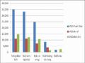
State-owned enterprises manage), in which: Agricultural land is 21.01 ha, accounting for 1.03%; Forestry land (managed by the National Park - land area with an altitude of 100m or more - forest land) is 1796.81 ha, accounting for 88.41%; Residential land is 153.59 ha, accounting for 7.56%, the rest is specialized land and other land. Agricultural land accounts for a small proportion and forest land accounts for the largest proportion in the total land area of the region, which shows the dependence of people's cultivated land on the land resources of the National Park. Land data of Ba Vi commune is detailed in table 3.2 and chart 3.1.
Table 3.2: Current land use status of Ba Vi commune in 2010
Unit: ha
Total natural area | Agricultural land industry (rice) | Forestry land (National Park) manage) | Residential land (household garden) | Special land use + other land | |
Acreage | 2032.46 | 21.01 | 1796.81 | 153.59 | 88.05 |
% | 100 | 1.03 | 88.41 | 7.56 | 4.33 |
((Source: Socio-economic summary report of Ba Vi commune, 2010)
Chart 3.1: Land structure of Ba Vi commune in 2010
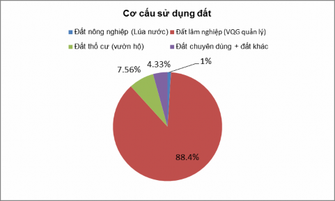
Table 3.3: Average cultivated land area per capita in Ba Vi commune in 2010
Unit: m2 / person
Soil type
Average area per head People | % | |
Rice | 117.31 | 1.1 |
Forestry land | 9881.69 | 91.0 |
Household garden | 857.69 | 7.9 |
Total | 10,856.56 | 100 |
Chart 3.2: Average cultivated land area in Ba Vi commune in 2010
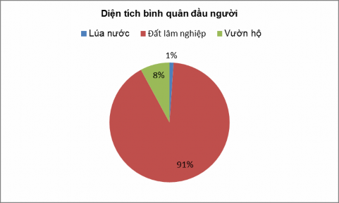
In general, the agricultural land area in the study area is small, an average of 117 m 2 / person, of which half is single-crop rice fields, the forest land area accounts for a large proportion compared to other types of land. The results of Table 3.3 and Chart 3.2 show that the average land area per capita of the community in the study area is very large (10,856.56 m 2 ), however, 91% of the total land is forest land managed by the National Park. Thus, the cultivated land area of the communities in the study area tends to be proportional to the forest land area, proving that their dependence on forest land exists.
(2) Productivity and yield of crops
The productivity of crops in Ba Vi commune is low. The average rice yield is 2.8 tons/ha/year, the cassava yield is 1.1 tons/ha....(Table 3.4)
Table 3.4: Productivity of food crops in Ba Vi.
Unit: tons/ha
Plants
Output | |
Rice all year round | 280 |
Corn all year round | 15 |
Potato | 40 |
Cassava | 110 |
Soybeans | 5.5 |
Lost | 8 |
Vegetables | 53 |
Beans | 6 |
Dong bien | 60 |
Source: People's Committee of Ba Vi commune
The average annual food production is 57.75 tons/ha. Annual food production in the study area is very limited due to lack of water for cultivation and lack of appropriate investment.
The proportion of flower crops accounts for 22.94% of total food production. The industry of processing flower products is not yet developed, only processing cassava flour and arrowroot flour by manual methods, on a household scale.
Fruit trees and short-term and long-term industrial trees are still few, there is no orientation for commodity production, mainly serving the local market. Fruit trees grown in home gardens have low productivity, the products are mainly used in the family.
Forestry trees are not given much attention by the local people. Very few households invest their own money to grow these trees, most of them grow trees with support from outside. Because food production is the immediate essential need of the local people.
(3) Animal husbandry
Currently, livestock farming is not developed in the area. The types of livestock raised by people are buffalo, cows, goats, and pigs. In addition to the main purpose of using buffalo and cows for traction, people also raise dairy cows and beef cattle. Livestock farming cannot be developed in the area because there is no grazing area.
Pig farming is developed in households that produce a lot of cassava flour, and cassava residue is used to feed pigs. Poultry production in the region is low compared to other regions, not meeting the local needs of the people.
3.1.2.3. Infrastructure
The commune has a 10KV power station and power lines to each hamlet. Currently, all families in the commune have electricity. Thanks to electricity, people's lives are changing, especially in terms of culture and spirit. With electricity, people will have access to the Party's policies, cultural information, and technology through radio and television. However, the commune's power system is still limited, that is, the power lines to the commune are small, so there are still power outages during peak hours.
Ba Vi commune has National Highway 87 running through it, connecting with National Highway 32 and National Highway 21A, so it is very convenient for exchanging goods with neighboring areas.
However, because it is a highland commune, the traffic system in the commune is all dirt roads, the roads are long and bumpy, making travel difficult, especially during the rainy season. The drainage system is not solidly built, so when it rains, it often causes erosion and landslides on the road surface.
Currently, the commune government is calling on organizations as well as state policies to support capital so that people in the commune can concrete the roads.
Regarding the irrigation system: The rice fields of the people in the villages are mainly located in low-lying areas, the irrigation water source mainly depends on the water flowing from the streams in the mountains. Besides, the commune does not have a system of canals and dams to retain water, so the activities in agricultural and forestry production of the people face many difficulties, especially in the dry season.
This is a problem that needs to be solved by the commune, so we need to research to propose solutions to help people more conveniently cultivate and increase crop productivity, contributing to economic development for local people.
Health situation: Currently, the commune has rebuilt the health station and put it into use to serve the people in the commune. Besides, most of the people here know about medicinal plants, so the health care of the people here is quite good.
Education situation: in the commune there is a primary and secondary school with 3 rows of level 4 houses with 10 classrooms and a team of quite young teachers from other places working here. The school in the commune has attracted many students in the commune and also students from other communes to study. Currently, Ba Vi commune is also planning to build a new school in the villages to serve the teaching and learning of the children here.
Thus, we can see that the infrastructure in the research area is still lacking, the facilities are not good. Therefore, there is a need for investment programs and projects, capital support for people to consolidate the infrastructure, thereby creating a foundation for local economic development according to the state's policy. That is to shorten the gap between rural and urban areas, mountainous areas and plains, bringing people's lives up day by day.
3.2. Current status of medicinal plant genetic resources conservation in Ba Vi National Park area
3.2.1. Key stakeholders in medicinal plant genetic resource conservation activities in Ba Vi National Park area
Through investigation and research, the project has identified the main stakeholders in conservation activities in the study area, including Ba Vi National Park and the local community in the study area. According to the results shown in Tables 3.2 and 3.3, most of the land area in Ba Vi is forestry land managed by Ba Vi National Park, and the local people are allocated land by the National Park for protection and cultivation.
3.2.2. Current status of management and conservation of medicinal plant genetic resources in Ba Vi National Park area
3.2.2.1. Current status of using medicinal plants and experience in using medicinal plants in Ba Vi commune
According to data provided by the Traditional Medicine Service Cooperative in Ba Vi, currently 283 medicinal plant species with many different life forms and distribution areas are used locally (Appendix 2). Each species has different uses and some plants can cure many diseases. A medicine often combines many medicinal herbs.
Table 3.5: Summary of life forms of medicinal plants used in Ba Vi commune
TT
State of existence | Number of species | % | |
1 | Large wood | 1 | 0.71 |
2 | Small wood | 51 | 18.09 |
3 | Shrub | 74 | 26.24 |
4 | Vine | 49 | 17.38 |
5 | Semi-parasitic grass | 3 | 1.06 |
6 | Grass | 103 | 36.52 |
Thus, the life forms of medicinal plants here are very diverse from: large trees, small trees, shrubs, vines, semi-parasitic grasses, grasses, they are in almost all different life forms from many to few. Medicinal plants have the largest number of life forms, usually herbaceous plants are mostly annuals or several years old, so it will be convenient for people to grow them to meet the demand for medicinal materials.
Table 3.6: Summary of parts used as medicine
TT
Parts used | Number of species | |
1 | Leaf | 159 |
2 | Body, branch | 136 |
3 | Roots | 42 |
4 | Root | 20 |
5 | Other parts | 15 |
The parts used as medicine of each plant species are also different, but it can be seen that in general, depending on the species and the purpose of treatment, people can take the leaves, stems, roots, tubers, and even some species take the whole plant to make medicine. This is also the reason that affects the medicinal plant resources in Ba Vi in particular and medicinal plants in other provinces in general. Low awareness of people combined with pressure from market demand makes people exploit medicinal plants unsustainably, they only care about the parts that need to be used, not caring about continued regeneration, leading to many medicinal plant species being threatened and extinct in the wild. Currently, in the locality, there are