(4) Developing adventure sports tourism products : This is a type of tourism that can be developed in places with difficult terrain such as sub-regions Ia and Xb.
(5) Developing eco-tourism products combined with medical resorts : this type of tourism develops in areas with mineral water, hot water and cool, fresh climate such as sub-region Va, region I, region VII, region III, region X.
=> Linking sub-regions and extra-regions to diversify tourism products to meet all customer needs. Developing new tourism products associated with museums, urban tourism associated with sports-adventure tourism centers associated with Yen Tu mountain areas, the northern mountainous areas and islands, etc.
3.2.2.2. Space exploitation orientation
Maybe you are interested!
-

 Applying Some Key Experiences in Human Resource Development for Marine Resources and Environment Management of Korea to Human Resource Development
 -
 Identify Rating Levels and Rating Scales
zt2i3t4l5ee
zt2a3gstourism,quan lan,quang ninh,ecology,ecotourism,minh chau,van don,geography,geographical basis,tourism development,science
zt2a3ge
zc2o3n4t5e6n7ts
of the islanders. Therefore, this indicator will be divided into two sub-indicators:
a1. Natural tourism attractiveness a2. Cultural tourism attractiveness
b. Tourist capacity
The two island communes in Quan Lan have different capacities to receive tourists. Minh Chau Commune is home to many standard hotels and resorts, attracting high-income domestic and international tourists. Meanwhile, Quan Lan Commune has many motels mainly built and operated by local people, so the scale and quality are not high, and will be suitable for ordinary tourists such as students.
c. Time of exploitation of Quan Lan Island Commune:
Quan Lan tourism is seasonal due to weather and climate conditions and festivals only take place on certain days of the year, specifically in spring. In Quan Lan commune, the period from April to June and from September to November is considered the best time to visit Quan Lan because the cultural tourism activities are mainly associated with festivals taking place during this time.
Minh Chau island commune:
Tourism exploitation time is all year round, because this is a place with a number of tourist attractions with diverse ecosystems such as Bai Tu Long National Park Research Center, Tram forest, Turtle Laying Beach, so besides coming to the beach for tourism and vacation in the summer, Minh Chau will attract research groups to come for tourism combined with research at other times of the year.
d. Sustainability
The sustainability of ecotourism sites in Quan Lan and Minh Chau communes depends on the sensitivity of the ecosystems to climate changes.
landscape. In general, these tourist destinations have a fairly high level of sustainability, because they are natural ecosystems, planned and protected. However, if a large number of tourists gather at certain times, it can exceed the carrying capacity and affect the sustainability of the environment (polluted beaches, damaged trees, animals moving away from their habitats, etc.), then the sustainability of the above ecosystems (natural ecosystems, human ecosystems) will also be affected and become less sustainable.
e. Location and accessibility
Both island communes have ports to take tourists to visit from Van Don wharf:
- Quan Lan – Van Don traffic route:
Phuc Thinh – Viet Anh high-speed boat and Quang Minh high-speed boat, depart at 8am and 2pm from Van Don to Quan Lan, and at 7am and 1pm from Quan Lan to Van Don. There are also wooden boats departing at 7am and 1pm.
- Van Don - Minh Chau traffic route:
Chung Huong high-speed train, Minh Chau train, morning 7:30 and afternoon 13:30 from Van Don to Minh Chau, morning 6:30 and afternoon 13:00 from Minh Chau to Van Don.
f. Infrastructure
Despite receiving investment attention, the issue of infrastructure and technical facilities for tourism on Quan Lan Island is still an issue that needs to be resolved because it has a direct impact on the implementation of ecotourism activities. The minimum conditions for serving tourists such as accommodation, electricity, water, communication, especially medical services, and security work need to be given top priority. Ecotourism spots in Minh Chau commune are assessed to have better infrastructure and technical facilities for tourism because there are quite complete and synchronous conditions for serving tourists, meeting many needs of domestic and foreign tourists.
3.2.1.4. Determine assessment levels and assessment scales
Corresponding to the levels of each criterion, the index is the score of those levels in the order of 4, 3, 2, 1 decreasing according to the standard of each level: very attractive (4), attractive (3), average (2), less attractive (1).
3.2.1.5. Determining the coefficients of the criteria
For the assessment of DLST in the two communes of Quan Lan and Minh Chau islands, the students added evaluation coefficients to show the importance of the criteria and indicators as follows:
Coefficient 3 with criteria: Attractiveness, Exploitation time. These are the 2 most important criteria for attracting tourists to tourism in general and eco-tourism in particular, so they have the highest coefficient.
Coefficient 2 with criteria: Capacity, Infrastructure, Location and accessibility . Because the assessment area is an island commune of Van Don district, the above criteria are selected by the author with appropriate coefficients at the average level.
Coefficient 1 with criteria: Sustainability. Quan Lan has natural and human-made ecotourism sites, with high biodiversity and little impact from local human factors. Most of the ecotourism sites are still wild, so they are highly sustainable.
3.2.1.6. Results of DLST assessment on Quan Lan island
a. Assessment of the potential for natural tourism development
For Minh Chau commune:
+ Natural tourism attractiveness is determined to be very attractive (4 points) and the most important coefficient (coefficient 3), so the score of the Attractiveness criterion is 4 x 3 = 12.
+ Capacity is determined as average (2 points) and the coefficient is quite important (coefficient 2), then the score of Capacity criterion is 2 x 2 = 4.
+ Exploitation time is long (4 points), the most important coefficient (coefficient 3) so the score of the Exploitation time criterion is 4 x 3 = 12.
+ Sustainability is determined as sustainable (4 points), the important coefficient is the average coefficient (coefficient 1), so the score of the Sustainability criterion is 4 x 1 = 4 points
+ Location and accessibility are determined to be quite favorable (2 points), the coefficient is quite important (coefficient 2), the criterion score is 2 x 2 = 4 points.
+ Infrastructure is assessed as good (3 points), the coefficient is quite important (coefficient 2), then the score of the Infrastructure criterion is 3 x 2 = 6 points.
The total score for evaluating DLST in Minh Chau commune according to 6 evaluation criteria is determined as: 12 + 4 + 12 + 4 + 4 + 6 = 42 points
Similar assessment for Quan Lan commune, we have the following table:
Table 3.3: Assessment of the potential for natural ecotourism development in Quan Lan and Minh Chau communes
Attractiveness of self-tourismof course
Capacity
Mining time
Sustainability
Location and accessibility
Infrastructure
Result
Point
DarkMulti
Point
DarkMulti
Point
DarkMulti
Point
DarkMulti
Point
DarkMulti
Point
DarkMulti
CommuneMinh Chau
12
12
4
8
12
12
4
4
4
8
6
8
42/52
Quan CommuneLan
6
12
6
8
9
12
4
4
4
8
4
8
33/52
b. Assessment of the potential for humanistic tourism development
For Quan Lan commune:
+ The attractiveness of human tourism is determined to be very attractive (4 points) and the most important coefficient (coefficient 3), so the score of the Attractiveness criterion is 4 x 3 = 12.
+ Capacity is determined to be large (3 points) and the coefficient is quite important (coefficient 2), then the score of the Capacity criterion is 3 x 2 = 6.
+ Mining time is average (3 points), the most important coefficient (coefficient 3) so the score of the Mining time criterion is 3 x 3 = 9.
+ Sustainability is determined as sustainable (4 points), the important coefficient is the average coefficient (coefficient 1), so the score of the Sustainability criterion is 4 x 1 = 4 points.
+ Location and accessibility are determined to be quite favorable (2 points), the coefficient is quite important (coefficient 2), the criterion score is 2 x 2 = 4 points.
+ Infrastructure is rated as average (2 points), the coefficient is quite important (coefficient 2), then the score of the Infrastructure criterion is 2 x 2 = 4 points.
The total score for evaluating DLST in Quan Lan commune according to 6 evaluation criteria is determined as: 12 + 6 + 6 + 4 + 4 + 4 = 36 points.
Similar assessment with Minh Chau commune we have the following table:
Table 3.4: Assessment of the potential for developing humanistic eco-tourism in Quan Lan and Minh Chau communes
Attractiveness of human tourismliterature
Capacity
Mining time
Sustainability
Location and accessibility
Infrastructure
Result
Point
DarkMulti
Point
DarkMulti
Point
DarkMulti
Point
DarkMulti
Point
DarkMulti
Point
DarkMulti
Quan CommuneLan
12
12
6
8
9
12
4
4
4
8
4
8
39/52
Minh CommuneChau
6
12
4
8
12
12
4
4
4
8
6
8
36/52
Basically, both Minh Chau and Quan Lan localities have quite favorable conditions for developing ecotourism. However, Quan Lan commune has more advantages to develop ecotourism in a humanistic direction, because this is an area with many famous historical relics such as Quan Lan Communal House, Quan Lan Pagoda, Temple worshiping the hero Tran Khanh Du, ... along with local festivals held annually such as the wind praying ceremony (March 15), Quan Lan festival (June 10-19); due to its location near the port and long exploitation time, the beaches in Quan Lan commune (especially Quan Lan beach) are no longer hygienic and clean to ensure the needs of tourists coming to relax and swim; this is also an area with many beautiful landscapes such as Got Beo wind pass, Ong Phong head, Voi Voi cave, but the ability to access these places is still very limited (dirt hill road, lots of gravel and rocks), especially during rainy and windy times; In addition, other natural resources such as mangrove forests and sea worms have not been really exploited for tourism purposes and ecotourism development. On the contrary, Minh Chau commune has more advantages in developing ecotourism in the direction of natural tourism, this is an area with diverse ecosystems such as at Rua De Beach, Bai Tu Long National Park Conservation Center...; Minh Chau beach is highly appreciated for its natural beauty and cleanliness, ranked in the top ten most beautiful beaches in Vietnam; Minh Chau commune is also home to Tram forest with a large area and a purity of up to 90%, suitable for building bridges through the forest (a very effective type of natural ecotourism currently applied by many countries) for tourists to sightsee, as well as for the purpose of studying and researching.
Figure 3.1: Thenmala Forest Bridge (India) Source: https://www.thenmalaecotourism.com/(August 21, 2019)
3.2.2. Using SWOT matrix to evaluate Quan Lan island tourism
General assessment of current tourism activities of Quan Lan island is shown through the following SWOT matrix:
Table 3.5: SWOT matrix evaluating tourism activities on Quan Lan island
Internal agent
Strengths- There is a lot of potential for tourism development, especially natural ecotourism and humanistic ecotourism.- The unskilled labor force is relatively abundant.- resource environmentunpolluted, still
Weaknesses- Poorly developed infrastructure, especially traffic routes to tourist destinations on the island.- The team of professional staff is still weak.- Tourism products in general
quite wild, originalintact
general and DLST in particularalone is monotonous.
External agents
Opportunity- Tourism is a key industry in the socio-economic development strategy of the province and Van Don economic zone.- Quan Lan was selected as a pilot area for eco-tourism development within the framework of the green growth project between Quang Ninh province and the Japanese organization JICA.- The flow of tourists and especially ecotourism in the world tends toincreasing
Challenge- Weather and climate change abnormally.- Competition in tourism products is increasingly fierce, especially with other localities in the province such as Ha Long, Mong Cai...- Awareness of tourists, especially domestic tourists, about ecotourism and nature conservation is not high.
Through summary analysis using SWOT matrix we see that:
To exploit strengths and take advantage of opportunities, it is necessary to:
- Diversify products and service types (build more tourism routes aimed at specific needs of tourists: experiential tourism immersed in nature, spiritual cultural tourism...)
- Effective exploitation of resources and differentiated products (natural resources and human resources)
div.maincontent .p { color: black; font-family:"Times New Roman", serif; font-style: normal; font-weight: normal; text-decoration: none; font-size: 14pt; margin:0pt; } div.maincontent p { color: black; font-family:"Times New Roman", serif; font-style: normal; font-weight: normal; text-decoration: none; font-size: 14pt; margin:0pt; } div.maincontent .s1 { color: black; font-family:"Times New Roman", serif; font-style: normal; font-weight: normal; text-decoration: none; font-size: 13pt; } div.maincontent .s2 { color: black; font-family:"Times New Roman", serif; font-style: normal; font-weight: normal; text-decoration: none; font-size: 13pt; } div.maincontent .s3 { color: #0D0D0D; font-family:"Times New Roman", serif; font-style: normal; font-weight: bold; text-decoration: none; font-size: 14pt; } div.maincontent .s4 { color: black; font-family:"Times New Roman", serif; font-style: italic; font-weight: normal; text-decoration: none; font-size: 14pt; } div.maincontent .s5 { color: black; font-family:"Times New Roman", serif; font-style: italic; font-weight: bold; text-decoration: none; font-size: 14pt; } div.maincontent .s6 { color: black; font-family:"Times New Roman", serif; font-style: italic; font-weight: normal; text-decoration: none; font-size: 14pt; vertical-align: -3pt; } div.maincontent .s7 { color: black; font-family:"Times New Roman", serif; font-style: italic; font-weight: normal; text-decoration: none; font-size: 14pt; vertical-align: -2pt; } div.maincontent .s8 { color: black; font-family:"Times New Roman", serif; font-style: italic; font-weight: normal; text-decoration: none; font-size: 14pt; vertical-align: -1pt; } div.maincontent .s9 { color: black; font-family:"Times New Roman", serif; font-style: normal; font-weight: normal; text-decoration: none; font-size: 14pt; } div.maincontent .s10 { color: black; font-family:"Times New Roman", serif; font-style: normal; font-weight: bold; text-decoration: none; font-size: 14pt; } div.maincontent .s11 { color: black; font-family:"Times New Roman", serif; font-style: normal; font-weight: normal; text-decoration: none; font-size: 14pt; } div.maincontent .s12 { color: black; font-family:Symbol, serif; font-style: normal; font-weight: normal; text-decoration: none; font-size: 14pt; } div.maincontent .s13 { color: black; font-family:Wingdings; font-style: normal; font-weight: normal; text-decoration: none; font-size: 14pt; } div.maincontent .s14 { color: black; font-family:"Times New Roman", serif; font-style: normal; font-weight: normal; text-decoration: none; font-size: 9pt; vertical-align: 5pt; } div.maincontent .s15 { color: black; font-family:"Times New Roman", serif; font-style: normal; font-weight: normal; text-decoration: none; font-size: 9pt; vertical-align: 5pt; } div.maincontent .s16 { color: black; font-family:Cambria, serif; font-style: italic; font-weight: normal; text-decoration: none; font-size: 14pt; } div.maincontent .s17 { color: #080808; font-family:"Times New Roman", serif; font-style: normal; font-weight: bold; text-decoration: none; font-size: 14pt; } div.maincontent .s18 { color: #080808; font-family:"Times New Roman", serif; font-style: normal; font-weight: normal; text-decoration: none; font-size: 14pt; } div.maincontent .s19 { color: black; font-family:"Times New Roman", serif; font-style: normal; font-weight: normal; text-decoration: none; font-size: 11pt; } div.maincontent .s20 { color: black; font-family:"Times New Roman", serif; font-style: normal; font-weight: normal; text-decoration: none; font-size: 10pt; } div.maincontent .s21 { color: black; font-family:"Times New Roman", serif; font-style: normal; font-weight: bold; text-decoration: none; font-size: 11pt; } div.maincontent .s22 { color: black; font-family:"Times New Roman", serif; font-style: normal; font-weight: normal; text-decoration: none; font-size: 11pt; } div.maincontent .s23 { color: black; font-family:"Times New Roman", serif; font-style: italic; font-weight: normal; text-decoration: none; font-size: 14pt; } div.maincontent .s24 { color: #212121; font-family:"Times New Roman", serif; font-style: normal; font-weight: normal; tex
Identify Rating Levels and Rating Scales
zt2i3t4l5ee
zt2a3gstourism,quan lan,quang ninh,ecology,ecotourism,minh chau,van don,geography,geographical basis,tourism development,science
zt2a3ge
zc2o3n4t5e6n7ts
of the islanders. Therefore, this indicator will be divided into two sub-indicators:
a1. Natural tourism attractiveness a2. Cultural tourism attractiveness
b. Tourist capacity
The two island communes in Quan Lan have different capacities to receive tourists. Minh Chau Commune is home to many standard hotels and resorts, attracting high-income domestic and international tourists. Meanwhile, Quan Lan Commune has many motels mainly built and operated by local people, so the scale and quality are not high, and will be suitable for ordinary tourists such as students.
c. Time of exploitation of Quan Lan Island Commune:
Quan Lan tourism is seasonal due to weather and climate conditions and festivals only take place on certain days of the year, specifically in spring. In Quan Lan commune, the period from April to June and from September to November is considered the best time to visit Quan Lan because the cultural tourism activities are mainly associated with festivals taking place during this time.
Minh Chau island commune:
Tourism exploitation time is all year round, because this is a place with a number of tourist attractions with diverse ecosystems such as Bai Tu Long National Park Research Center, Tram forest, Turtle Laying Beach, so besides coming to the beach for tourism and vacation in the summer, Minh Chau will attract research groups to come for tourism combined with research at other times of the year.
d. Sustainability
The sustainability of ecotourism sites in Quan Lan and Minh Chau communes depends on the sensitivity of the ecosystems to climate changes.
landscape. In general, these tourist destinations have a fairly high level of sustainability, because they are natural ecosystems, planned and protected. However, if a large number of tourists gather at certain times, it can exceed the carrying capacity and affect the sustainability of the environment (polluted beaches, damaged trees, animals moving away from their habitats, etc.), then the sustainability of the above ecosystems (natural ecosystems, human ecosystems) will also be affected and become less sustainable.
e. Location and accessibility
Both island communes have ports to take tourists to visit from Van Don wharf:
- Quan Lan – Van Don traffic route:
Phuc Thinh – Viet Anh high-speed boat and Quang Minh high-speed boat, depart at 8am and 2pm from Van Don to Quan Lan, and at 7am and 1pm from Quan Lan to Van Don. There are also wooden boats departing at 7am and 1pm.
- Van Don - Minh Chau traffic route:
Chung Huong high-speed train, Minh Chau train, morning 7:30 and afternoon 13:30 from Van Don to Minh Chau, morning 6:30 and afternoon 13:00 from Minh Chau to Van Don.
f. Infrastructure
Despite receiving investment attention, the issue of infrastructure and technical facilities for tourism on Quan Lan Island is still an issue that needs to be resolved because it has a direct impact on the implementation of ecotourism activities. The minimum conditions for serving tourists such as accommodation, electricity, water, communication, especially medical services, and security work need to be given top priority. Ecotourism spots in Minh Chau commune are assessed to have better infrastructure and technical facilities for tourism because there are quite complete and synchronous conditions for serving tourists, meeting many needs of domestic and foreign tourists.
3.2.1.4. Determine assessment levels and assessment scales
Corresponding to the levels of each criterion, the index is the score of those levels in the order of 4, 3, 2, 1 decreasing according to the standard of each level: very attractive (4), attractive (3), average (2), less attractive (1).
3.2.1.5. Determining the coefficients of the criteria
For the assessment of DLST in the two communes of Quan Lan and Minh Chau islands, the students added evaluation coefficients to show the importance of the criteria and indicators as follows:
Coefficient 3 with criteria: Attractiveness, Exploitation time. These are the 2 most important criteria for attracting tourists to tourism in general and eco-tourism in particular, so they have the highest coefficient.
Coefficient 2 with criteria: Capacity, Infrastructure, Location and accessibility . Because the assessment area is an island commune of Van Don district, the above criteria are selected by the author with appropriate coefficients at the average level.
Coefficient 1 with criteria: Sustainability. Quan Lan has natural and human-made ecotourism sites, with high biodiversity and little impact from local human factors. Most of the ecotourism sites are still wild, so they are highly sustainable.
3.2.1.6. Results of DLST assessment on Quan Lan island
a. Assessment of the potential for natural tourism development
For Minh Chau commune:
+ Natural tourism attractiveness is determined to be very attractive (4 points) and the most important coefficient (coefficient 3), so the score of the Attractiveness criterion is 4 x 3 = 12.
+ Capacity is determined as average (2 points) and the coefficient is quite important (coefficient 2), then the score of Capacity criterion is 2 x 2 = 4.
+ Exploitation time is long (4 points), the most important coefficient (coefficient 3) so the score of the Exploitation time criterion is 4 x 3 = 12.
+ Sustainability is determined as sustainable (4 points), the important coefficient is the average coefficient (coefficient 1), so the score of the Sustainability criterion is 4 x 1 = 4 points
+ Location and accessibility are determined to be quite favorable (2 points), the coefficient is quite important (coefficient 2), the criterion score is 2 x 2 = 4 points.
+ Infrastructure is assessed as good (3 points), the coefficient is quite important (coefficient 2), then the score of the Infrastructure criterion is 3 x 2 = 6 points.
The total score for evaluating DLST in Minh Chau commune according to 6 evaluation criteria is determined as: 12 + 4 + 12 + 4 + 4 + 6 = 42 points
Similar assessment for Quan Lan commune, we have the following table:
Table 3.3: Assessment of the potential for natural ecotourism development in Quan Lan and Minh Chau communes
Attractiveness of self-tourismof course
Capacity
Mining time
Sustainability
Location and accessibility
Infrastructure
Result
Point
DarkMulti
Point
DarkMulti
Point
DarkMulti
Point
DarkMulti
Point
DarkMulti
Point
DarkMulti
CommuneMinh Chau
12
12
4
8
12
12
4
4
4
8
6
8
42/52
Quan CommuneLan
6
12
6
8
9
12
4
4
4
8
4
8
33/52
b. Assessment of the potential for humanistic tourism development
For Quan Lan commune:
+ The attractiveness of human tourism is determined to be very attractive (4 points) and the most important coefficient (coefficient 3), so the score of the Attractiveness criterion is 4 x 3 = 12.
+ Capacity is determined to be large (3 points) and the coefficient is quite important (coefficient 2), then the score of the Capacity criterion is 3 x 2 = 6.
+ Mining time is average (3 points), the most important coefficient (coefficient 3) so the score of the Mining time criterion is 3 x 3 = 9.
+ Sustainability is determined as sustainable (4 points), the important coefficient is the average coefficient (coefficient 1), so the score of the Sustainability criterion is 4 x 1 = 4 points.
+ Location and accessibility are determined to be quite favorable (2 points), the coefficient is quite important (coefficient 2), the criterion score is 2 x 2 = 4 points.
+ Infrastructure is rated as average (2 points), the coefficient is quite important (coefficient 2), then the score of the Infrastructure criterion is 2 x 2 = 4 points.
The total score for evaluating DLST in Quan Lan commune according to 6 evaluation criteria is determined as: 12 + 6 + 6 + 4 + 4 + 4 = 36 points.
Similar assessment with Minh Chau commune we have the following table:
Table 3.4: Assessment of the potential for developing humanistic eco-tourism in Quan Lan and Minh Chau communes
Attractiveness of human tourismliterature
Capacity
Mining time
Sustainability
Location and accessibility
Infrastructure
Result
Point
DarkMulti
Point
DarkMulti
Point
DarkMulti
Point
DarkMulti
Point
DarkMulti
Point
DarkMulti
Quan CommuneLan
12
12
6
8
9
12
4
4
4
8
4
8
39/52
Minh CommuneChau
6
12
4
8
12
12
4
4
4
8
6
8
36/52
Basically, both Minh Chau and Quan Lan localities have quite favorable conditions for developing ecotourism. However, Quan Lan commune has more advantages to develop ecotourism in a humanistic direction, because this is an area with many famous historical relics such as Quan Lan Communal House, Quan Lan Pagoda, Temple worshiping the hero Tran Khanh Du, ... along with local festivals held annually such as the wind praying ceremony (March 15), Quan Lan festival (June 10-19); due to its location near the port and long exploitation time, the beaches in Quan Lan commune (especially Quan Lan beach) are no longer hygienic and clean to ensure the needs of tourists coming to relax and swim; this is also an area with many beautiful landscapes such as Got Beo wind pass, Ong Phong head, Voi Voi cave, but the ability to access these places is still very limited (dirt hill road, lots of gravel and rocks), especially during rainy and windy times; In addition, other natural resources such as mangrove forests and sea worms have not been really exploited for tourism purposes and ecotourism development. On the contrary, Minh Chau commune has more advantages in developing ecotourism in the direction of natural tourism, this is an area with diverse ecosystems such as at Rua De Beach, Bai Tu Long National Park Conservation Center...; Minh Chau beach is highly appreciated for its natural beauty and cleanliness, ranked in the top ten most beautiful beaches in Vietnam; Minh Chau commune is also home to Tram forest with a large area and a purity of up to 90%, suitable for building bridges through the forest (a very effective type of natural ecotourism currently applied by many countries) for tourists to sightsee, as well as for the purpose of studying and researching.
Figure 3.1: Thenmala Forest Bridge (India) Source: https://www.thenmalaecotourism.com/(August 21, 2019)
3.2.2. Using SWOT matrix to evaluate Quan Lan island tourism
General assessment of current tourism activities of Quan Lan island is shown through the following SWOT matrix:
Table 3.5: SWOT matrix evaluating tourism activities on Quan Lan island
Internal agent
Strengths- There is a lot of potential for tourism development, especially natural ecotourism and humanistic ecotourism.- The unskilled labor force is relatively abundant.- resource environmentunpolluted, still
Weaknesses- Poorly developed infrastructure, especially traffic routes to tourist destinations on the island.- The team of professional staff is still weak.- Tourism products in general
quite wild, originalintact
general and DLST in particularalone is monotonous.
External agents
Opportunity- Tourism is a key industry in the socio-economic development strategy of the province and Van Don economic zone.- Quan Lan was selected as a pilot area for eco-tourism development within the framework of the green growth project between Quang Ninh province and the Japanese organization JICA.- The flow of tourists and especially ecotourism in the world tends toincreasing
Challenge- Weather and climate change abnormally.- Competition in tourism products is increasingly fierce, especially with other localities in the province such as Ha Long, Mong Cai...- Awareness of tourists, especially domestic tourists, about ecotourism and nature conservation is not high.
Through summary analysis using SWOT matrix we see that:
To exploit strengths and take advantage of opportunities, it is necessary to:
- Diversify products and service types (build more tourism routes aimed at specific needs of tourists: experiential tourism immersed in nature, spiritual cultural tourism...)
- Effective exploitation of resources and differentiated products (natural resources and human resources)
div.maincontent .p { color: black; font-family:"Times New Roman", serif; font-style: normal; font-weight: normal; text-decoration: none; font-size: 14pt; margin:0pt; } div.maincontent p { color: black; font-family:"Times New Roman", serif; font-style: normal; font-weight: normal; text-decoration: none; font-size: 14pt; margin:0pt; } div.maincontent .s1 { color: black; font-family:"Times New Roman", serif; font-style: normal; font-weight: normal; text-decoration: none; font-size: 13pt; } div.maincontent .s2 { color: black; font-family:"Times New Roman", serif; font-style: normal; font-weight: normal; text-decoration: none; font-size: 13pt; } div.maincontent .s3 { color: #0D0D0D; font-family:"Times New Roman", serif; font-style: normal; font-weight: bold; text-decoration: none; font-size: 14pt; } div.maincontent .s4 { color: black; font-family:"Times New Roman", serif; font-style: italic; font-weight: normal; text-decoration: none; font-size: 14pt; } div.maincontent .s5 { color: black; font-family:"Times New Roman", serif; font-style: italic; font-weight: bold; text-decoration: none; font-size: 14pt; } div.maincontent .s6 { color: black; font-family:"Times New Roman", serif; font-style: italic; font-weight: normal; text-decoration: none; font-size: 14pt; vertical-align: -3pt; } div.maincontent .s7 { color: black; font-family:"Times New Roman", serif; font-style: italic; font-weight: normal; text-decoration: none; font-size: 14pt; vertical-align: -2pt; } div.maincontent .s8 { color: black; font-family:"Times New Roman", serif; font-style: italic; font-weight: normal; text-decoration: none; font-size: 14pt; vertical-align: -1pt; } div.maincontent .s9 { color: black; font-family:"Times New Roman", serif; font-style: normal; font-weight: normal; text-decoration: none; font-size: 14pt; } div.maincontent .s10 { color: black; font-family:"Times New Roman", serif; font-style: normal; font-weight: bold; text-decoration: none; font-size: 14pt; } div.maincontent .s11 { color: black; font-family:"Times New Roman", serif; font-style: normal; font-weight: normal; text-decoration: none; font-size: 14pt; } div.maincontent .s12 { color: black; font-family:Symbol, serif; font-style: normal; font-weight: normal; text-decoration: none; font-size: 14pt; } div.maincontent .s13 { color: black; font-family:Wingdings; font-style: normal; font-weight: normal; text-decoration: none; font-size: 14pt; } div.maincontent .s14 { color: black; font-family:"Times New Roman", serif; font-style: normal; font-weight: normal; text-decoration: none; font-size: 9pt; vertical-align: 5pt; } div.maincontent .s15 { color: black; font-family:"Times New Roman", serif; font-style: normal; font-weight: normal; text-decoration: none; font-size: 9pt; vertical-align: 5pt; } div.maincontent .s16 { color: black; font-family:Cambria, serif; font-style: italic; font-weight: normal; text-decoration: none; font-size: 14pt; } div.maincontent .s17 { color: #080808; font-family:"Times New Roman", serif; font-style: normal; font-weight: bold; text-decoration: none; font-size: 14pt; } div.maincontent .s18 { color: #080808; font-family:"Times New Roman", serif; font-style: normal; font-weight: normal; text-decoration: none; font-size: 14pt; } div.maincontent .s19 { color: black; font-family:"Times New Roman", serif; font-style: normal; font-weight: normal; text-decoration: none; font-size: 11pt; } div.maincontent .s20 { color: black; font-family:"Times New Roman", serif; font-style: normal; font-weight: normal; text-decoration: none; font-size: 10pt; } div.maincontent .s21 { color: black; font-family:"Times New Roman", serif; font-style: normal; font-weight: bold; text-decoration: none; font-size: 11pt; } div.maincontent .s22 { color: black; font-family:"Times New Roman", serif; font-style: normal; font-weight: normal; text-decoration: none; font-size: 11pt; } div.maincontent .s23 { color: black; font-family:"Times New Roman", serif; font-style: italic; font-weight: normal; text-decoration: none; font-size: 14pt; } div.maincontent .s24 { color: #212121; font-family:"Times New Roman", serif; font-style: normal; font-weight: normal; tex -
 Management of capacity building in organizing experiential activities in a multicultural educational environment for teachers of primary schools in Bac Kan city - 16
 -
 Current Status of Human Resource Training at the Institute of Occupational Health and Environment
 -
 Solutions to improve human resource management at Anh Viet Informatics Company Limited by 2015 - 5
a) Priority development sub-regions
As analyzed above, the zoning of the Northeast region is a scientific and highly objective organization of territorial space. The results of the zoning of the Northeast region are the basis for the assessment and use of territorial resources to serve socio-economic development in general and tourism in particular. Therefore, the zoning of the Northeast region is a scientific organization of space. The assessment of the level of favorable conditions for developing sustainable tourism is based on 22 zoning complexes to find zoning complexes with favorable conditions for ecotourism resources and the attractiveness of tourism resources for each region. From there, there is a basis for concentrating resources, investing in exploitation in the most reasonable and optimal way and ensuring sustainable development of the territory.
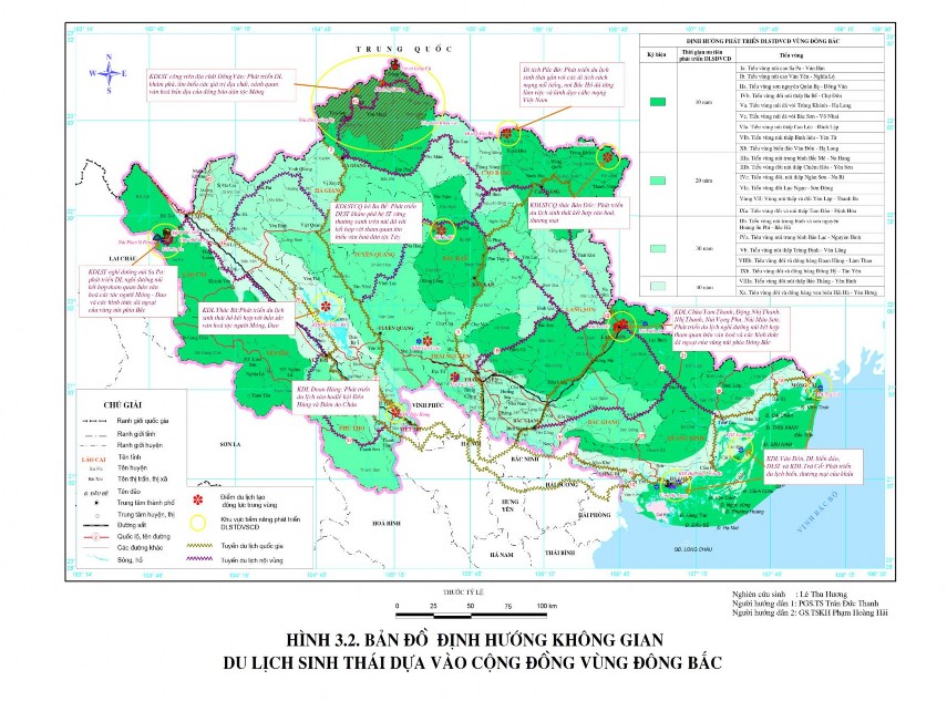
From the above analysis and assessment results of the favorable level for community-based ecotourism, the development orientation according to sub-regions is as follows: focus and prioritize the exploitation of sub-regions with valuable ecotourism resources and very favorable for community-based ecotourism development such as region I, sub-regions IIa, IVb, Va, Vc, VIa, VIb, Xb and expand development to sub-regions that are favorable and relatively favorable for community-based ecotourism development such as: region III, region VII, sub-regions IVc, VIc, Ixa; sub-regions IIb, IVa, Vb, VIIIb, IXb (Figure 3.2).
To specify the priority level, based on the comprehensive assessment of the favorable level for the development of Northeast tourism, it is necessary to divide the regions and sub-regions for investment and exploitation in different stages. Specifically (Figure 3.2):
- Phase 1 (within 10 years) : Priority is given to areas with very favorable conditions for developing community-based ecotourism such as region I and sub-regions IIa, IVb, Va, Vc, VIa, VIb, Xb. These are sub-regions with diverse and rich ecotourism resources as well as high tourism attractiveness. Therefore, the task for the above areas in this phase is to complete infrastructure, technical infrastructure to serve tourism and train local communities to participate in ecotourism activities in the most effective way.
- Phase 2 (within 20 years): priority is given to areas that are considered favorable for the development of community-based ecotourism such as Region III, Region VII, Sub-regions IVc, VIc, IXa. In these areas, it is necessary to promote existing strengths and gradually improve factors that are considered unfavorable for ecotourism development such as infrastructure, technical facilities serving tourism or to raise awareness and train the community to participate in ecotourism development.
- Phase 3 (within 30 years): this phase is for areas that are relatively favorable for developing community-based tourism such as: Sub-regions IIb, IVa, Vb, VIIIb, IXb. In these areas, there should be strategies for re-planning space, finding forms of exploitation and development of ecotourism. From there, specific strategies should be developed for building infrastructure, tourism infrastructure as well as attracting and training the community to participate in sustainable tourism development.
- Phase 4 (within 40 years): this phase is for areas that are less favorable for developing community-based tourism such as: sub-region VIIIa and Xa sub-region. In these areas, there should be a plan to survey and plan locations with potential for community-based tourism development in order to propose measures to exploit space, develop products, attract investment and train the community to participate in tourism.
b) Orientation of development according to key points and locations and creating motivation
In each sub-region, the distribution and concentration of resources are uneven. To optimally develop the potential, it is necessary to identify areas of resource concentration - the driving points, key areas as the basis for creating spatial linkages between sub-regions. Based on the results of the assessment of the favorable level of 22 regions and sub-regions. Orientation,
In the research area, spatial development is carried out in 9 key areas including (Figure 3.2):
1) Sapa - Van Ban highland sub-region
Community-based tourism development area: Sa Pa mountain resort eco-tourism area (Lao Cai) : Developing mountain resort tourism combined with visiting cultural villages of the H'Mong - Dao ethnic groups and forms of picnics in the northern mountainous region.
2) Quan Ba - Dong Van mountain sub-region
Area for developing community-based tourism : Dong Van Geopark Ecotourism Area (Ha Giang) Developing tourism to explore and learn about the geological values, landscapes, and indigenous culture of the H'Mong ethnic group.
3) Ba Be - Cho Don low mountain hill sub-region
Community-based tourism development area: Ba Be Lake landscape ecotourism area (Bac Kan) : Developing ecotourism to explore the evergreen forest ecosystem on limestone mountains combined with sightseeing to learn about the indigenous culture of the Tay ethnic group.
4) Chongqing - Ha Lang limestone mountain sub-region
Community-based tourism development area : Ban Gioc waterfall landscape eco-tourism area (Cao Bang) - is a place with beautiful and majestic ecological landscape, culture of the Tay and Nung ethnic groups. Developing sightseeing tourism combined with culture, trade...; Pac Bo relic - Eco-tourism associated with famous revolutionary relics, where Uncle Ho used to work and directly lead the Vietnamese Revolution. The name Pac Bo literally means " source mouth". The relics in this area include: Bo Bam cave, Co Rac beach, Coc Bo cave - where Uncle Ho chose to live and lead the Vietnamese Revolution after 30 years of wandering back to the Fatherland in 1941; Lenin stream, Karl Marx mountain; Nam stream: Where
President Ho Chi Minh directly trained cadres and organized many important meetings of the Central Committee.
Thus, this sub-region can develop eco-tourism to visit landscape protection areas combined with learning about President Ho Chi Minh during the resistance years.
5) Tam Dao - Dinh Hoa hill and low mountain sub-region
DLSTDVCĐ development area: developing eco-tourism associated with the windy resistance capital ATK Dinh Hoa.
6) Van Don - Ha Long island sub-region
Community-based tourism development areas: Van Don tourist area (Quang Ninh): sea and island tourism, eco-tourism and Tra Co tourist area (Quang Ninh) - sea eco-tourism, border gate trade.
7) Low mountainous sub-region of Bao Thang - Yen Binh
Community-based tourism development area: Thac Ba (Yen Bai) - is one of the largest freshwater lakes in our country with attractive natural landscapes, rich vegetation, ethnic minority villages with many cultural characteristics of the northern mountainous region... Developing lake ecotourism combined with the cultural identity of the H'Mong-Dao ethnic group here.
8) Doan Hung - Lam Thao hill and plain sub-region
Development area of community-based tourism: Doan Hung (Phu Tho) - is the ancestral land of the Vietnamese people. Here the Hung Kings established Van Lang - the first nation of Vietnam, with Phong Chau as the capital. The terrain of the sub-region is mainly mountainous with three major rivers flowing through: Red River (Thao River), Lo River and Da River. Cultural tourism area of Hung Temple Festival and Ao Chau Lagoon (Phu Tho).
9) Cao Loc - Dinh Lap lowland sub-region
Areas for developing community-based tourism: Tam Thanh Pagoda, Nhi Thanh Cave, Vong Phu Mountain, Mau Son Mountain (Lang Son). Developing mountain resort tourism combined with visiting cultural villages and other forms of outdoor activities in the Northeastern mountainous region.
Through the above tourist destinations, intra-regional and inter-regional tourist routes will be built, thereby helping areas with very/quite favorable conditions to fully promote their strengths, but at the same time leading to the development of areas with the ability or not yet having the conditions to exploit and develop properly.
c) Orientation of tourism route development
The organization of tourist routes in the study area is based on:
- The distribution of selected tourist spots and areas, and especially the regional and territorial hubs. In the region, 6 important hubs are identified, including: Lao Cai, Lang Son, Thai Nguyen, Cao Bang, Bac Kan and Hanoi, which are the hubs of the entire region and the north of our country.
- Current status of distribution and development orientation of infrastructure, especially traffic
- The ability to provide services and environmental landscapes on routes creates products that have great appeal to tourists.
- The dynamic economic development corridors of the region aim to expand development space to the North and towards the sea. The dynamic development corridors follow the vertical axes of National Highway 18, National Highway 5, National Highway 10 and the regional sea route system.
The orientation of the PTDL route system in the Northeast region is organized into intra-regional routes and extra-regional routes. In which (Figure 3.2):
i) Regional routes include:
+ Lao Cai (Sa Pa) - Yen Bai - Ha Giang - Cao Bang - Lang Son route: This route plays a role in connecting tourist resorts and exploring the Mu Cang Chai terraced fields, the Kasrt cave system such as Tam Thanh, Nhi Thanh and the Mau Son mountain resort eco-tourism area. This route can develop mountain resort tourism combined with visiting cultural villages and forms of picnics in the Northeast mountainous region.
+ Yen Bai (Yen Binh) - Bac Kan (Ba Be) - Lang Son (Dong Mo) route: This route plays a role in connecting tourist destinations such as Mu Cang Chai terraced fields, Ba Be National Park, Kasrt cave systems such as Tam Thanh, Nhi Thanh and eco-resort areas.
Mau Son Mountain. This route can develop mountain resort tourism combined with cultural village visits and other forms of outdoor activities in the Northeastern mountainous region.
+ Thai Nguyen - Ba Be - Cao Bang (Ban Gioc) - Lang Son route: This route plays a role in connecting mountain lake ecological areas such as Nui Coc Lake, Ba Be Lake, Ban Gioc Waterfall or Mau Son Mountain area. These are also areas with many indigenous cultural values preserved intact by the Tay, Nung ethnic groups... Therefore, this route can develop lake ecotourism combined with the cultural identity of the ethnic groups here.
+ Bac Giang - Lang Son - Cao Bang - Bac Kan - Thai Nguyen - Tuyen Quang - Ha Giang route. This is the route connecting national parks, nature reserves, historical sites... which are also home to many ethnic minority communities. This route can develop eco-tourism to explore the evergreen forest ecosystem on limestone mountains; explore and learn about geological values, landscapes, biodiversity and indigenous culture of ethnic minorities.
+ Phu Tho (Viet Tri) - Yen Bai - Lao Cai (Sa Pa) route: The role of the route is to connect areas with geological values, landscapes, biodiversity (Ao Chau lagoon, Mu Cang Chai terraced fields, Thac Ba tourist area, Sa Pa tourist area, Hoang Lien National Park...) and indigenous cultural values such as festivals and customs of the H'Mong-Dao ethnic minorities. This route can develop discovery tourism, learning about geological values, landscapes, biodiversity and indigenous culture of ethnic minorities.
ii) Inter-regional tourist routes include: national and international routes. The focal point for sending visitors and the international transit point is identified as Hanoi. In addition, there are also centers, which are international border gates in the region or on the economic development corridors of the whole region. Inter-regional routes include:
+ Lang Son - Hanoi - Northern Delta provinces (RD).
+ Cao Bang - Bac Kan - Thai Nguyen - Hanoi - provinces in the Red River Delta
+ Ha Giang - Tuyen Quang - Phu Tho - Hanoi - provinces in the Red River Delta
+ Kunming (China)-Lao Cai-Hanoi - Hai Phong - Quang Ninh.
+ Nanning (China) - Lang Son - Hanoi - Hai Phong - Quang Ninh.
The above routes not only play a role in promoting the region's strengths in community-based tourism but also promote the advantages of many other types of tourism, contributing to the diversity and uniqueness of tourism products while creating outstanding features of the nature and culture of the Northeast region. From there, they create connections with localities at home and abroad to develop the economy and society of the whole region.
3.2.2.3. Orientation of resource management and environmental protection
a) Sustainable resource management
- Planning PTDLSTDVCĐ in stages and adjusting from time to time to suit the development situation.
- Issue legal documents on tourism activities and protection of natural resources for the entire region and each tourist destination in accordance with development reality.
- Regarding administration, close coordination and connection between localities in managing and exploiting natural resources to serve sustainable development of community-based tourism.
b) Environmental protection for sustainable development
- Developing community-based tourism, focusing on pristine natural elements and indigenous cultural values but ensuring that the environment is the factor that creates attractiveness, determines quality and creates a tourism brand for the region.
- Forecast of areas/points that may be overloaded in terms of environmental capacity: SaPa, Ba Be, Dong Van stone plateau, Ban Gioc waterfall, Pac Bo relic site, Ha Long, Van Don, in sub-regions Ia, IIa, IVa, Va, Xb.'
- Protecting the natural environment in exploiting ecotourism, linking ecotourism activities towards preserving and promoting the value of resources and protecting the environment.
- PTDL goes hand in hand with restoring and promoting unique traditional cultural values in localities.