 Basic and field research for conservation needs.
 Carry out scientific research services, educational propaganda combined with ecotourism services.
 Coordinate with local authorities to build and manage buffer zones.
Maybe you are interested!
-
 Natural Conditions, Socio-Economics and Resources for Tourism Development of Hai Phong
 -
 Principles and Methods of Evaluating Natural Conditions and Natural Resources for Tourism Development
 -
 Identify Rating Levels and Rating Scales
zt2i3t4l5ee
zt2a3gstourism,quan lan,quang ninh,ecology,ecotourism,minh chau,van don,geography,geographical basis,tourism development,science
zt2a3ge
zc2o3n4t5e6n7ts
of the islanders. Therefore, this indicator will be divided into two sub-indicators:
a1. Natural tourism attractiveness a2. Cultural tourism attractiveness
b. Tourist capacity
The two island communes in Quan Lan have different capacities to receive tourists. Minh Chau Commune is home to many standard hotels and resorts, attracting high-income domestic and international tourists. Meanwhile, Quan Lan Commune has many motels mainly built and operated by local people, so the scale and quality are not high, and will be suitable for ordinary tourists such as students.
c. Time of exploitation of Quan Lan Island Commune:
Quan Lan tourism is seasonal due to weather and climate conditions and festivals only take place on certain days of the year, specifically in spring. In Quan Lan commune, the period from April to June and from September to November is considered the best time to visit Quan Lan because the cultural tourism activities are mainly associated with festivals taking place during this time.
Minh Chau island commune:
Tourism exploitation time is all year round, because this is a place with a number of tourist attractions with diverse ecosystems such as Bai Tu Long National Park Research Center, Tram forest, Turtle Laying Beach, so besides coming to the beach for tourism and vacation in the summer, Minh Chau will attract research groups to come for tourism combined with research at other times of the year.
d. Sustainability
The sustainability of ecotourism sites in Quan Lan and Minh Chau communes depends on the sensitivity of the ecosystems to climate changes.
landscape. In general, these tourist destinations have a fairly high level of sustainability, because they are natural ecosystems, planned and protected. However, if a large number of tourists gather at certain times, it can exceed the carrying capacity and affect the sustainability of the environment (polluted beaches, damaged trees, animals moving away from their habitats, etc.), then the sustainability of the above ecosystems (natural ecosystems, human ecosystems) will also be affected and become less sustainable.
e. Location and accessibility
Both island communes have ports to take tourists to visit from Van Don wharf:
- Quan Lan – Van Don traffic route:
Phuc Thinh – Viet Anh high-speed boat and Quang Minh high-speed boat, depart at 8am and 2pm from Van Don to Quan Lan, and at 7am and 1pm from Quan Lan to Van Don. There are also wooden boats departing at 7am and 1pm.
- Van Don - Minh Chau traffic route:
Chung Huong high-speed train, Minh Chau train, morning 7:30 and afternoon 13:30 from Van Don to Minh Chau, morning 6:30 and afternoon 13:00 from Minh Chau to Van Don.
f. Infrastructure
Despite receiving investment attention, the issue of infrastructure and technical facilities for tourism on Quan Lan Island is still an issue that needs to be resolved because it has a direct impact on the implementation of ecotourism activities. The minimum conditions for serving tourists such as accommodation, electricity, water, communication, especially medical services, and security work need to be given top priority. Ecotourism spots in Minh Chau commune are assessed to have better infrastructure and technical facilities for tourism because there are quite complete and synchronous conditions for serving tourists, meeting many needs of domestic and foreign tourists.
3.2.1.4. Determine assessment levels and assessment scales
Corresponding to the levels of each criterion, the index is the score of those levels in the order of 4, 3, 2, 1 decreasing according to the standard of each level: very attractive (4), attractive (3), average (2), less attractive (1).
3.2.1.5. Determining the coefficients of the criteria
For the assessment of DLST in the two communes of Quan Lan and Minh Chau islands, the students added evaluation coefficients to show the importance of the criteria and indicators as follows:
Coefficient 3 with criteria: Attractiveness, Exploitation time. These are the 2 most important criteria for attracting tourists to tourism in general and eco-tourism in particular, so they have the highest coefficient.
Coefficient 2 with criteria: Capacity, Infrastructure, Location and accessibility . Because the assessment area is an island commune of Van Don district, the above criteria are selected by the author with appropriate coefficients at the average level.
Coefficient 1 with criteria: Sustainability. Quan Lan has natural and human-made ecotourism sites, with high biodiversity and little impact from local human factors. Most of the ecotourism sites are still wild, so they are highly sustainable.
3.2.1.6. Results of DLST assessment on Quan Lan island
a. Assessment of the potential for natural tourism development
For Minh Chau commune:
+ Natural tourism attractiveness is determined to be very attractive (4 points) and the most important coefficient (coefficient 3), so the score of the Attractiveness criterion is 4 x 3 = 12.
+ Capacity is determined as average (2 points) and the coefficient is quite important (coefficient 2), then the score of Capacity criterion is 2 x 2 = 4.
+ Exploitation time is long (4 points), the most important coefficient (coefficient 3) so the score of the Exploitation time criterion is 4 x 3 = 12.
+ Sustainability is determined as sustainable (4 points), the important coefficient is the average coefficient (coefficient 1), so the score of the Sustainability criterion is 4 x 1 = 4 points
+ Location and accessibility are determined to be quite favorable (2 points), the coefficient is quite important (coefficient 2), the criterion score is 2 x 2 = 4 points.
+ Infrastructure is assessed as good (3 points), the coefficient is quite important (coefficient 2), then the score of the Infrastructure criterion is 3 x 2 = 6 points.
The total score for evaluating DLST in Minh Chau commune according to 6 evaluation criteria is determined as: 12 + 4 + 12 + 4 + 4 + 6 = 42 points
Similar assessment for Quan Lan commune, we have the following table:
Table 3.3: Assessment of the potential for natural ecotourism development in Quan Lan and Minh Chau communes
Attractiveness of self-tourismof course
Capacity
Mining time
Sustainability
Location and accessibility
Infrastructure
Result
Point
DarkMulti
Point
DarkMulti
Point
DarkMulti
Point
DarkMulti
Point
DarkMulti
Point
DarkMulti
CommuneMinh Chau
12
12
4
8
12
12
4
4
4
8
6
8
42/52
Quan CommuneLan
6
12
6
8
9
12
4
4
4
8
4
8
33/52
b. Assessment of the potential for humanistic tourism development
For Quan Lan commune:
+ The attractiveness of human tourism is determined to be very attractive (4 points) and the most important coefficient (coefficient 3), so the score of the Attractiveness criterion is 4 x 3 = 12.
+ Capacity is determined to be large (3 points) and the coefficient is quite important (coefficient 2), then the score of the Capacity criterion is 3 x 2 = 6.
+ Mining time is average (3 points), the most important coefficient (coefficient 3) so the score of the Mining time criterion is 3 x 3 = 9.
+ Sustainability is determined as sustainable (4 points), the important coefficient is the average coefficient (coefficient 1), so the score of the Sustainability criterion is 4 x 1 = 4 points.
+ Location and accessibility are determined to be quite favorable (2 points), the coefficient is quite important (coefficient 2), the criterion score is 2 x 2 = 4 points.
+ Infrastructure is rated as average (2 points), the coefficient is quite important (coefficient 2), then the score of the Infrastructure criterion is 2 x 2 = 4 points.
The total score for evaluating DLST in Quan Lan commune according to 6 evaluation criteria is determined as: 12 + 6 + 6 + 4 + 4 + 4 = 36 points.
Similar assessment with Minh Chau commune we have the following table:
Table 3.4: Assessment of the potential for developing humanistic eco-tourism in Quan Lan and Minh Chau communes
Attractiveness of human tourismliterature
Capacity
Mining time
Sustainability
Location and accessibility
Infrastructure
Result
Point
DarkMulti
Point
DarkMulti
Point
DarkMulti
Point
DarkMulti
Point
DarkMulti
Point
DarkMulti
Quan CommuneLan
12
12
6
8
9
12
4
4
4
8
4
8
39/52
Minh CommuneChau
6
12
4
8
12
12
4
4
4
8
6
8
36/52
Basically, both Minh Chau and Quan Lan localities have quite favorable conditions for developing ecotourism. However, Quan Lan commune has more advantages to develop ecotourism in a humanistic direction, because this is an area with many famous historical relics such as Quan Lan Communal House, Quan Lan Pagoda, Temple worshiping the hero Tran Khanh Du, ... along with local festivals held annually such as the wind praying ceremony (March 15), Quan Lan festival (June 10-19); due to its location near the port and long exploitation time, the beaches in Quan Lan commune (especially Quan Lan beach) are no longer hygienic and clean to ensure the needs of tourists coming to relax and swim; this is also an area with many beautiful landscapes such as Got Beo wind pass, Ong Phong head, Voi Voi cave, but the ability to access these places is still very limited (dirt hill road, lots of gravel and rocks), especially during rainy and windy times; In addition, other natural resources such as mangrove forests and sea worms have not been really exploited for tourism purposes and ecotourism development. On the contrary, Minh Chau commune has more advantages in developing ecotourism in the direction of natural tourism, this is an area with diverse ecosystems such as at Rua De Beach, Bai Tu Long National Park Conservation Center...; Minh Chau beach is highly appreciated for its natural beauty and cleanliness, ranked in the top ten most beautiful beaches in Vietnam; Minh Chau commune is also home to Tram forest with a large area and a purity of up to 90%, suitable for building bridges through the forest (a very effective type of natural ecotourism currently applied by many countries) for tourists to sightsee, as well as for the purpose of studying and researching.
Figure 3.1: Thenmala Forest Bridge (India) Source: https://www.thenmalaecotourism.com/(August 21, 2019)
3.2.2. Using SWOT matrix to evaluate Quan Lan island tourism
General assessment of current tourism activities of Quan Lan island is shown through the following SWOT matrix:
Table 3.5: SWOT matrix evaluating tourism activities on Quan Lan island
Internal agent
Strengths- There is a lot of potential for tourism development, especially natural ecotourism and humanistic ecotourism.- The unskilled labor force is relatively abundant.- resource environmentunpolluted, still
Weaknesses- Poorly developed infrastructure, especially traffic routes to tourist destinations on the island.- The team of professional staff is still weak.- Tourism products in general
quite wild, originalintact
general and DLST in particularalone is monotonous.
External agents
Opportunity- Tourism is a key industry in the socio-economic development strategy of the province and Van Don economic zone.- Quan Lan was selected as a pilot area for eco-tourism development within the framework of the green growth project between Quang Ninh province and the Japanese organization JICA.- The flow of tourists and especially ecotourism in the world tends toincreasing
Challenge- Weather and climate change abnormally.- Competition in tourism products is increasingly fierce, especially with other localities in the province such as Ha Long, Mong Cai...- Awareness of tourists, especially domestic tourists, about ecotourism and nature conservation is not high.
Through summary analysis using SWOT matrix we see that:
To exploit strengths and take advantage of opportunities, it is necessary to:
- Diversify products and service types (build more tourism routes aimed at specific needs of tourists: experiential tourism immersed in nature, spiritual cultural tourism...)
- Effective exploitation of resources and differentiated products (natural resources and human resources)
div.maincontent .p { color: black; font-family:"Times New Roman", serif; font-style: normal; font-weight: normal; text-decoration: none; font-size: 14pt; margin:0pt; } div.maincontent p { color: black; font-family:"Times New Roman", serif; font-style: normal; font-weight: normal; text-decoration: none; font-size: 14pt; margin:0pt; } div.maincontent .s1 { color: black; font-family:"Times New Roman", serif; font-style: normal; font-weight: normal; text-decoration: none; font-size: 13pt; } div.maincontent .s2 { color: black; font-family:"Times New Roman", serif; font-style: normal; font-weight: normal; text-decoration: none; font-size: 13pt; } div.maincontent .s3 { color: #0D0D0D; font-family:"Times New Roman", serif; font-style: normal; font-weight: bold; text-decoration: none; font-size: 14pt; } div.maincontent .s4 { color: black; font-family:"Times New Roman", serif; font-style: italic; font-weight: normal; text-decoration: none; font-size: 14pt; } div.maincontent .s5 { color: black; font-family:"Times New Roman", serif; font-style: italic; font-weight: bold; text-decoration: none; font-size: 14pt; } div.maincontent .s6 { color: black; font-family:"Times New Roman", serif; font-style: italic; font-weight: normal; text-decoration: none; font-size: 14pt; vertical-align: -3pt; } div.maincontent .s7 { color: black; font-family:"Times New Roman", serif; font-style: italic; font-weight: normal; text-decoration: none; font-size: 14pt; vertical-align: -2pt; } div.maincontent .s8 { color: black; font-family:"Times New Roman", serif; font-style: italic; font-weight: normal; text-decoration: none; font-size: 14pt; vertical-align: -1pt; } div.maincontent .s9 { color: black; font-family:"Times New Roman", serif; font-style: normal; font-weight: normal; text-decoration: none; font-size: 14pt; } div.maincontent .s10 { color: black; font-family:"Times New Roman", serif; font-style: normal; font-weight: bold; text-decoration: none; font-size: 14pt; } div.maincontent .s11 { color: black; font-family:"Times New Roman", serif; font-style: normal; font-weight: normal; text-decoration: none; font-size: 14pt; } div.maincontent .s12 { color: black; font-family:Symbol, serif; font-style: normal; font-weight: normal; text-decoration: none; font-size: 14pt; } div.maincontent .s13 { color: black; font-family:Wingdings; font-style: normal; font-weight: normal; text-decoration: none; font-size: 14pt; } div.maincontent .s14 { color: black; font-family:"Times New Roman", serif; font-style: normal; font-weight: normal; text-decoration: none; font-size: 9pt; vertical-align: 5pt; } div.maincontent .s15 { color: black; font-family:"Times New Roman", serif; font-style: normal; font-weight: normal; text-decoration: none; font-size: 9pt; vertical-align: 5pt; } div.maincontent .s16 { color: black; font-family:Cambria, serif; font-style: italic; font-weight: normal; text-decoration: none; font-size: 14pt; } div.maincontent .s17 { color: #080808; font-family:"Times New Roman", serif; font-style: normal; font-weight: bold; text-decoration: none; font-size: 14pt; } div.maincontent .s18 { color: #080808; font-family:"Times New Roman", serif; font-style: normal; font-weight: normal; text-decoration: none; font-size: 14pt; } div.maincontent .s19 { color: black; font-family:"Times New Roman", serif; font-style: normal; font-weight: normal; text-decoration: none; font-size: 11pt; } div.maincontent .s20 { color: black; font-family:"Times New Roman", serif; font-style: normal; font-weight: normal; text-decoration: none; font-size: 10pt; } div.maincontent .s21 { color: black; font-family:"Times New Roman", serif; font-style: normal; font-weight: bold; text-decoration: none; font-size: 11pt; } div.maincontent .s22 { color: black; font-family:"Times New Roman", serif; font-style: normal; font-weight: normal; text-decoration: none; font-size: 11pt; } div.maincontent .s23 { color: black; font-family:"Times New Roman", serif; font-style: italic; font-weight: normal; text-decoration: none; font-size: 14pt; } div.maincontent .s24 { color: #212121; font-family:"Times New Roman", serif; font-style: normal; font-weight: normal; tex
Identify Rating Levels and Rating Scales
zt2i3t4l5ee
zt2a3gstourism,quan lan,quang ninh,ecology,ecotourism,minh chau,van don,geography,geographical basis,tourism development,science
zt2a3ge
zc2o3n4t5e6n7ts
of the islanders. Therefore, this indicator will be divided into two sub-indicators:
a1. Natural tourism attractiveness a2. Cultural tourism attractiveness
b. Tourist capacity
The two island communes in Quan Lan have different capacities to receive tourists. Minh Chau Commune is home to many standard hotels and resorts, attracting high-income domestic and international tourists. Meanwhile, Quan Lan Commune has many motels mainly built and operated by local people, so the scale and quality are not high, and will be suitable for ordinary tourists such as students.
c. Time of exploitation of Quan Lan Island Commune:
Quan Lan tourism is seasonal due to weather and climate conditions and festivals only take place on certain days of the year, specifically in spring. In Quan Lan commune, the period from April to June and from September to November is considered the best time to visit Quan Lan because the cultural tourism activities are mainly associated with festivals taking place during this time.
Minh Chau island commune:
Tourism exploitation time is all year round, because this is a place with a number of tourist attractions with diverse ecosystems such as Bai Tu Long National Park Research Center, Tram forest, Turtle Laying Beach, so besides coming to the beach for tourism and vacation in the summer, Minh Chau will attract research groups to come for tourism combined with research at other times of the year.
d. Sustainability
The sustainability of ecotourism sites in Quan Lan and Minh Chau communes depends on the sensitivity of the ecosystems to climate changes.
landscape. In general, these tourist destinations have a fairly high level of sustainability, because they are natural ecosystems, planned and protected. However, if a large number of tourists gather at certain times, it can exceed the carrying capacity and affect the sustainability of the environment (polluted beaches, damaged trees, animals moving away from their habitats, etc.), then the sustainability of the above ecosystems (natural ecosystems, human ecosystems) will also be affected and become less sustainable.
e. Location and accessibility
Both island communes have ports to take tourists to visit from Van Don wharf:
- Quan Lan – Van Don traffic route:
Phuc Thinh – Viet Anh high-speed boat and Quang Minh high-speed boat, depart at 8am and 2pm from Van Don to Quan Lan, and at 7am and 1pm from Quan Lan to Van Don. There are also wooden boats departing at 7am and 1pm.
- Van Don - Minh Chau traffic route:
Chung Huong high-speed train, Minh Chau train, morning 7:30 and afternoon 13:30 from Van Don to Minh Chau, morning 6:30 and afternoon 13:00 from Minh Chau to Van Don.
f. Infrastructure
Despite receiving investment attention, the issue of infrastructure and technical facilities for tourism on Quan Lan Island is still an issue that needs to be resolved because it has a direct impact on the implementation of ecotourism activities. The minimum conditions for serving tourists such as accommodation, electricity, water, communication, especially medical services, and security work need to be given top priority. Ecotourism spots in Minh Chau commune are assessed to have better infrastructure and technical facilities for tourism because there are quite complete and synchronous conditions for serving tourists, meeting many needs of domestic and foreign tourists.
3.2.1.4. Determine assessment levels and assessment scales
Corresponding to the levels of each criterion, the index is the score of those levels in the order of 4, 3, 2, 1 decreasing according to the standard of each level: very attractive (4), attractive (3), average (2), less attractive (1).
3.2.1.5. Determining the coefficients of the criteria
For the assessment of DLST in the two communes of Quan Lan and Minh Chau islands, the students added evaluation coefficients to show the importance of the criteria and indicators as follows:
Coefficient 3 with criteria: Attractiveness, Exploitation time. These are the 2 most important criteria for attracting tourists to tourism in general and eco-tourism in particular, so they have the highest coefficient.
Coefficient 2 with criteria: Capacity, Infrastructure, Location and accessibility . Because the assessment area is an island commune of Van Don district, the above criteria are selected by the author with appropriate coefficients at the average level.
Coefficient 1 with criteria: Sustainability. Quan Lan has natural and human-made ecotourism sites, with high biodiversity and little impact from local human factors. Most of the ecotourism sites are still wild, so they are highly sustainable.
3.2.1.6. Results of DLST assessment on Quan Lan island
a. Assessment of the potential for natural tourism development
For Minh Chau commune:
+ Natural tourism attractiveness is determined to be very attractive (4 points) and the most important coefficient (coefficient 3), so the score of the Attractiveness criterion is 4 x 3 = 12.
+ Capacity is determined as average (2 points) and the coefficient is quite important (coefficient 2), then the score of Capacity criterion is 2 x 2 = 4.
+ Exploitation time is long (4 points), the most important coefficient (coefficient 3) so the score of the Exploitation time criterion is 4 x 3 = 12.
+ Sustainability is determined as sustainable (4 points), the important coefficient is the average coefficient (coefficient 1), so the score of the Sustainability criterion is 4 x 1 = 4 points
+ Location and accessibility are determined to be quite favorable (2 points), the coefficient is quite important (coefficient 2), the criterion score is 2 x 2 = 4 points.
+ Infrastructure is assessed as good (3 points), the coefficient is quite important (coefficient 2), then the score of the Infrastructure criterion is 3 x 2 = 6 points.
The total score for evaluating DLST in Minh Chau commune according to 6 evaluation criteria is determined as: 12 + 4 + 12 + 4 + 4 + 6 = 42 points
Similar assessment for Quan Lan commune, we have the following table:
Table 3.3: Assessment of the potential for natural ecotourism development in Quan Lan and Minh Chau communes
Attractiveness of self-tourismof course
Capacity
Mining time
Sustainability
Location and accessibility
Infrastructure
Result
Point
DarkMulti
Point
DarkMulti
Point
DarkMulti
Point
DarkMulti
Point
DarkMulti
Point
DarkMulti
CommuneMinh Chau
12
12
4
8
12
12
4
4
4
8
6
8
42/52
Quan CommuneLan
6
12
6
8
9
12
4
4
4
8
4
8
33/52
b. Assessment of the potential for humanistic tourism development
For Quan Lan commune:
+ The attractiveness of human tourism is determined to be very attractive (4 points) and the most important coefficient (coefficient 3), so the score of the Attractiveness criterion is 4 x 3 = 12.
+ Capacity is determined to be large (3 points) and the coefficient is quite important (coefficient 2), then the score of the Capacity criterion is 3 x 2 = 6.
+ Mining time is average (3 points), the most important coefficient (coefficient 3) so the score of the Mining time criterion is 3 x 3 = 9.
+ Sustainability is determined as sustainable (4 points), the important coefficient is the average coefficient (coefficient 1), so the score of the Sustainability criterion is 4 x 1 = 4 points.
+ Location and accessibility are determined to be quite favorable (2 points), the coefficient is quite important (coefficient 2), the criterion score is 2 x 2 = 4 points.
+ Infrastructure is rated as average (2 points), the coefficient is quite important (coefficient 2), then the score of the Infrastructure criterion is 2 x 2 = 4 points.
The total score for evaluating DLST in Quan Lan commune according to 6 evaluation criteria is determined as: 12 + 6 + 6 + 4 + 4 + 4 = 36 points.
Similar assessment with Minh Chau commune we have the following table:
Table 3.4: Assessment of the potential for developing humanistic eco-tourism in Quan Lan and Minh Chau communes
Attractiveness of human tourismliterature
Capacity
Mining time
Sustainability
Location and accessibility
Infrastructure
Result
Point
DarkMulti
Point
DarkMulti
Point
DarkMulti
Point
DarkMulti
Point
DarkMulti
Point
DarkMulti
Quan CommuneLan
12
12
6
8
9
12
4
4
4
8
4
8
39/52
Minh CommuneChau
6
12
4
8
12
12
4
4
4
8
6
8
36/52
Basically, both Minh Chau and Quan Lan localities have quite favorable conditions for developing ecotourism. However, Quan Lan commune has more advantages to develop ecotourism in a humanistic direction, because this is an area with many famous historical relics such as Quan Lan Communal House, Quan Lan Pagoda, Temple worshiping the hero Tran Khanh Du, ... along with local festivals held annually such as the wind praying ceremony (March 15), Quan Lan festival (June 10-19); due to its location near the port and long exploitation time, the beaches in Quan Lan commune (especially Quan Lan beach) are no longer hygienic and clean to ensure the needs of tourists coming to relax and swim; this is also an area with many beautiful landscapes such as Got Beo wind pass, Ong Phong head, Voi Voi cave, but the ability to access these places is still very limited (dirt hill road, lots of gravel and rocks), especially during rainy and windy times; In addition, other natural resources such as mangrove forests and sea worms have not been really exploited for tourism purposes and ecotourism development. On the contrary, Minh Chau commune has more advantages in developing ecotourism in the direction of natural tourism, this is an area with diverse ecosystems such as at Rua De Beach, Bai Tu Long National Park Conservation Center...; Minh Chau beach is highly appreciated for its natural beauty and cleanliness, ranked in the top ten most beautiful beaches in Vietnam; Minh Chau commune is also home to Tram forest with a large area and a purity of up to 90%, suitable for building bridges through the forest (a very effective type of natural ecotourism currently applied by many countries) for tourists to sightsee, as well as for the purpose of studying and researching.
Figure 3.1: Thenmala Forest Bridge (India) Source: https://www.thenmalaecotourism.com/(August 21, 2019)
3.2.2. Using SWOT matrix to evaluate Quan Lan island tourism
General assessment of current tourism activities of Quan Lan island is shown through the following SWOT matrix:
Table 3.5: SWOT matrix evaluating tourism activities on Quan Lan island
Internal agent
Strengths- There is a lot of potential for tourism development, especially natural ecotourism and humanistic ecotourism.- The unskilled labor force is relatively abundant.- resource environmentunpolluted, still
Weaknesses- Poorly developed infrastructure, especially traffic routes to tourist destinations on the island.- The team of professional staff is still weak.- Tourism products in general
quite wild, originalintact
general and DLST in particularalone is monotonous.
External agents
Opportunity- Tourism is a key industry in the socio-economic development strategy of the province and Van Don economic zone.- Quan Lan was selected as a pilot area for eco-tourism development within the framework of the green growth project between Quang Ninh province and the Japanese organization JICA.- The flow of tourists and especially ecotourism in the world tends toincreasing
Challenge- Weather and climate change abnormally.- Competition in tourism products is increasingly fierce, especially with other localities in the province such as Ha Long, Mong Cai...- Awareness of tourists, especially domestic tourists, about ecotourism and nature conservation is not high.
Through summary analysis using SWOT matrix we see that:
To exploit strengths and take advantage of opportunities, it is necessary to:
- Diversify products and service types (build more tourism routes aimed at specific needs of tourists: experiential tourism immersed in nature, spiritual cultural tourism...)
- Effective exploitation of resources and differentiated products (natural resources and human resources)
div.maincontent .p { color: black; font-family:"Times New Roman", serif; font-style: normal; font-weight: normal; text-decoration: none; font-size: 14pt; margin:0pt; } div.maincontent p { color: black; font-family:"Times New Roman", serif; font-style: normal; font-weight: normal; text-decoration: none; font-size: 14pt; margin:0pt; } div.maincontent .s1 { color: black; font-family:"Times New Roman", serif; font-style: normal; font-weight: normal; text-decoration: none; font-size: 13pt; } div.maincontent .s2 { color: black; font-family:"Times New Roman", serif; font-style: normal; font-weight: normal; text-decoration: none; font-size: 13pt; } div.maincontent .s3 { color: #0D0D0D; font-family:"Times New Roman", serif; font-style: normal; font-weight: bold; text-decoration: none; font-size: 14pt; } div.maincontent .s4 { color: black; font-family:"Times New Roman", serif; font-style: italic; font-weight: normal; text-decoration: none; font-size: 14pt; } div.maincontent .s5 { color: black; font-family:"Times New Roman", serif; font-style: italic; font-weight: bold; text-decoration: none; font-size: 14pt; } div.maincontent .s6 { color: black; font-family:"Times New Roman", serif; font-style: italic; font-weight: normal; text-decoration: none; font-size: 14pt; vertical-align: -3pt; } div.maincontent .s7 { color: black; font-family:"Times New Roman", serif; font-style: italic; font-weight: normal; text-decoration: none; font-size: 14pt; vertical-align: -2pt; } div.maincontent .s8 { color: black; font-family:"Times New Roman", serif; font-style: italic; font-weight: normal; text-decoration: none; font-size: 14pt; vertical-align: -1pt; } div.maincontent .s9 { color: black; font-family:"Times New Roman", serif; font-style: normal; font-weight: normal; text-decoration: none; font-size: 14pt; } div.maincontent .s10 { color: black; font-family:"Times New Roman", serif; font-style: normal; font-weight: bold; text-decoration: none; font-size: 14pt; } div.maincontent .s11 { color: black; font-family:"Times New Roman", serif; font-style: normal; font-weight: normal; text-decoration: none; font-size: 14pt; } div.maincontent .s12 { color: black; font-family:Symbol, serif; font-style: normal; font-weight: normal; text-decoration: none; font-size: 14pt; } div.maincontent .s13 { color: black; font-family:Wingdings; font-style: normal; font-weight: normal; text-decoration: none; font-size: 14pt; } div.maincontent .s14 { color: black; font-family:"Times New Roman", serif; font-style: normal; font-weight: normal; text-decoration: none; font-size: 9pt; vertical-align: 5pt; } div.maincontent .s15 { color: black; font-family:"Times New Roman", serif; font-style: normal; font-weight: normal; text-decoration: none; font-size: 9pt; vertical-align: 5pt; } div.maincontent .s16 { color: black; font-family:Cambria, serif; font-style: italic; font-weight: normal; text-decoration: none; font-size: 14pt; } div.maincontent .s17 { color: #080808; font-family:"Times New Roman", serif; font-style: normal; font-weight: bold; text-decoration: none; font-size: 14pt; } div.maincontent .s18 { color: #080808; font-family:"Times New Roman", serif; font-style: normal; font-weight: normal; text-decoration: none; font-size: 14pt; } div.maincontent .s19 { color: black; font-family:"Times New Roman", serif; font-style: normal; font-weight: normal; text-decoration: none; font-size: 11pt; } div.maincontent .s20 { color: black; font-family:"Times New Roman", serif; font-style: normal; font-weight: normal; text-decoration: none; font-size: 10pt; } div.maincontent .s21 { color: black; font-family:"Times New Roman", serif; font-style: normal; font-weight: bold; text-decoration: none; font-size: 11pt; } div.maincontent .s22 { color: black; font-family:"Times New Roman", serif; font-style: normal; font-weight: normal; text-decoration: none; font-size: 11pt; } div.maincontent .s23 { color: black; font-family:"Times New Roman", serif; font-style: italic; font-weight: normal; text-decoration: none; font-size: 14pt; } div.maincontent .s24 { color: #212121; font-family:"Times New Roman", serif; font-style: normal; font-weight: normal; tex -
 Assessment of natural conditions and resources for tourism development in mountainous districts of Tri - Thien - 24 region
 -
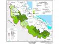 Map of Assessment of the Favorability of Natural Resources for Tourism Development in Mountainous Districts of Tri - Thien Area
2.2 Natural conditions and natural tourism resources
2.2.1 Geographical location
Cat Ba National Park is located on Cat Ba Island, geographical coordinates 20 o 43'50"-20 o 51'29" North latitude, 106 o 58'20"-107 o 10'05" East longitude.
The park is located on the largest island of Cat Ba archipelago, 60km from Hai Phong city and 160km from Hanoi capital. The north borders Gia Luan commune, the east borders Ha Long Bay, the west borders Cat Ba town and the communes of Xuan Dam, Tran Chau, Hien Hao.
The National Park is located in the Cat Ba archipelago - which was recognized by UNESCO as a world biosphere reserve on April 1, 2004. Not only that, next to Cat Ba are also extremely attractive tourist destinations such as: Ha Long Bay - one of the world's natural heritages in Vietnam, Do Son tourist area. This has highlighted the natural value of the National Park in the system of neighboring tourist destinations.
From the above analysis, we can see that the National Park has a very favorable location and is easy to attract tourists. Combining tourist attractions in Quang Ninh and Hai Phong city with natural tourist attractions in the National Park will create a very unique tourism product for visitors.
2.2.2 Terrain
Cat Ba Island, including a fairly large main island and 366 large and small islands spread out over a large sea area, forming many calm bays such as Cat Ba Bay, Lan Ha Bay, Viet Hai Bay...
The entire Cat Ba National Park consists of a rugged mountainous area with an altitude of <500m, most of which are in the range of 50-200m. The National Park has an area of about 15,200ha, of which the mainland area is 9,800ha and the sea surface area is 5,400ha. Covering the entire Cat Ba Island are limestone mountain ranges with an average altitude of 150m above sea level. The highest is Cao Vong peak (322m).
Between the limestone mountains are relatively flat valleys that can be used for agriculture such as Khe Sau field, Tep field, or form Gia Luan valley, Dang valley, Che valley, Bang valley.
Cave topography is a characteristic of Cat Ba. The caves are not large, have beautiful shapes, many stalactites, many cave niches such as Da Hoa Gia Luan cave, Trung Trang cave, Quan Y cave... This place has many beautiful beaches such as Bai Cat Dua, Van Hoi, Cat Co...
2.2.3 Land
Cat Ba National Park has 5 main soil groups:
Soil group on limestone mountains. This is a type of reddish brown or yellowish brown weathered soil developed on limestone and sandstone mountains, soil layer >50cm, ph = 6.5-7 Distributed under the forest canopy, scattered in the garden.
The yellow-brown or light-brown feralit soil group develops on slightly acidic or nearly neutral limestone products. In this soil group, there is also a type of gray-white or yellow-brown feralit that develops on acidic shale shale in bare hills, with thin soil layers, poor structure, mixed with rocks, and loose dry soil.
Valley soil group develops on limestone mountains concentrated in valleys, covered by natural forests.
Flooded valley soil group develops mainly due to the alluvial process, often flooded in the rainy season, with an average or thin topsoil layer.
The group of alluvial soils is a product of alluvial deposition at river mouths, developed on the saltwater areas in Cai Vieng and Phu Long.
2.2.4 Climate-hydrology
2.2.4.1 Climate
The climate at a tourist destination plays a very important role in tourism activities. It is a factor that creates tourism demand and also a factor that helps tourists choose the time to visit and have fun at that destination. For the National Park, climate is a factor that determines the seasonality of tourism activities.
Because it is located in the Northern Tropic of Cancer, Cat Ba, like the Northeast region of Vietnam, is directly affected by the tropical monsoon climate. In addition, because it is located in the middle of the sea, Cat Ba's climate is also oceanic, less harsh than areas of the same latitude on the mainland. In the summer, the climate in Cat Ba is very cool and pleasant.
About heat and radiation:
- The area is affected by tropical radiation so the thermal radiation balance is always positive, the average annual temperature is 25-28 0 C and is divided into two seasons due to the influence of polar circulation:
 Summer (May-September), highest in July, average temperature 28-30 o C
 Winter (November-April) is cold, lowest in January with average temperature of 14-16 o C
- Temperature also changes according to season and wind regime, the average in summer is 27.9 0 C, in winter is 19.8 0 C. In summer, the hottest months are 5,6 and 7, the temperature reaches 35-36 0 C and lasts all day. In winter, the coldest months
Especially in December, January and February, the temperature sometimes drops below 10 degrees Celsius and lasts for 5-7 days.
10 o C.
- The temperature difference between the two seasons is quite clear: 8-10 o C.
- The fluctuation between day and night is 5-6 o C, the center of the island can reach up to
- Total heat is 8000-8500 o C/year.
- Heat radiation: Because the sun's altitude is high in all months of the year, the heat radiation is
Solar radiation has a fairly high value. Average annual thermal radiation reaches 110-115kcal/ cm2 .
Air humidity:
Relative humidity is quite high, the annual average is about 85%, the lowest is January: 76% and the highest is April: 91%.
Rainfall:
- Total annual rainfall is 1,700 - 1,800 mm, divided into two distinct seasons.
obvious:
+ Rainy season (May-October) has an average of over 10 rainy days/month total
Rainfall 1500m - 1600m, accounting for 80-90% of annual rainfall. Heaviest rain is in July, August and September due to heavy showers and strong storms and tropical depressions.
+ Dry season (November - April) has an average of 6 - 8 rainy days/month with total rainfall of 200 - 250mm. The beginning of the season is often dry and the end of the season is often wet due to light rain and drizzle.
Atmospheric circulation and wind regime:
- The wind regime in the whole area is influenced by the general atmospheric circulation and changes seasonally. The average annual wind speed is 2.5m/s, highest in July (3.4m/s) and lowest in January (1.8m/s). In summer, the southeast monsoon has a prevailing direction from the southeast and south, with an average speed of 2.5-3.0m/s, maximum
20 – 30m/s. In winter, the northeast monsoon winds prevail from the north and northeast, then change to the east and northeast at the end of the season, with an average speed of 2.5-3.0m/s, and a maximum speed of 20-25m/s.
- In addition to the two main wind directions, every year in Cat Ba there is a hot dry wind from the West. There are an average of 2 waves per year, sometimes 5 waves, sometimes lasting up to 10 days. During these days the temperature is above 39 degrees Celsius, humidity drops to 55%. This type of wind usually appears from June to August.
- Storms in Cat Ba can appear early from April and last until the end of October, but are concentrated in July, August and September. On average, there are 2.5 storms per year, sometimes 6, the average is level 8 to level 10, the highest is level 14, with heavy rainfall from 50-1000mm.
2.2.4.2 Hydrological regime
Due to the limestone terrain, strong karst phenomenon with many caves and crevices, the terrain surface on Cat Ba island does not have regular rivers and streams, but only shallow streams that lead water to drainage channels during the rainy season.
During the rainy season, water stagnates in small areas, seeping into caves. Although very little, this is a fairly regular source of fresh water for animals and plants and provides for the island's residents.
Typical underground stream systems are: Thuong Luong stream, Treo Com stream, Hai Trung Trang stream, Viet Hai stream. A valuable water source is Ao Ech. It is a natural lake with an area of about 3 hectares, maintaining a water level of about 50cm all year round on a limestone mountain area, rugged mountains, right in the center of the primeval forest.
2.2.5 Biological resources
Plants
Cat Ba Forest is considered a unique natural forest located in the middle of the vast ocean. On Cat Ba island, the limestone mountain area occupies 19,827 hectares, of which the tree-covered area is 13,200 hectares, accounting for 60%.
Due to the rugged limestone terrain, this place still retains a typical evergreen tropical rainforest of the North. Cat Ba forest has a main type of evergreen tropical rainforest in the lowlands. However, due to the terrain, soil and flooding conditions, there are some sub-types such as: forest on limestone mountains, mangrove forests and flooded forests with the characteristic of trees and water in Ao Ech area creating a very unique landscape.
- Forests in valleys, arroyos and limestone foothills have 3 layers of trees, canopy cover of 0.6 to 0.8 and are less impacted:
+ The first floor is over 20m high with trees such as dracontomelon, goi nep, phay, sang le, ca lo, lim xet.
+ The second floor is over 12m high and includes cassia, cassia, garcinia and pomelo trees.
+ The 3rd floor is over 8m high and includes small trees from the two upper floors and other trees such as thau linh and trong dua.
There is absolutely no grass layer, only where the forest canopy expands are there leaves and foliage.
Exogenous plants are usually woody vines such as wild grapes, ivy, and gourd vines.
This type of forest usually has a timber reserve of 80-150m3 distributed in the valleys and estuaries of the center of Cat Ba island such as Lut Trong estuary, Lut Ngoai estuary, Re Bo Da estuary, Man Tau estuary, Mai Co estuary, Cay Cau estuary, Rang estuary, May Bau estuary, Phay estuary, Man Chay, along the road and in the valleys from Viet Hai to Tra Bau and from Tra Bau to Gia Luan.
- Forests on limestone slopes are also less affected. The soil is often covered with rocks accounting for 50 - 70%, the canopy of the forest is from 0.4 - 0.6. The forest layer is simpler with only two layers of trees:
+ The first floor is 15 - 20m high and includes trees such as mulberry, areca, forest longan... where the soil layer is thick, there are scattered Bac Son palms 20 - 30m high.
+ The second floor is under 10m high and has bamboo shoots, pigweed, and seedlings of the upper floor.
+ The grass layer has succulent plants of the family Acanthus and Orchidaceae.
- The forest on the top of limestone mountains is always windy, so the trees are usually no more than 5m high, the ground cover is only 1-2 layers. The plants are usually blood dragon, Eclipta prostrata, green tangerine, honey hook... scattered with split palm trees with a canopy of 0.2-0.3. Under the canopy, there are cacti, mountain bird's feet growing mixed with climbing plants and shrubs such as cow's hoof vine, war plant. In places with strong winds, there are usually only bamboo chopsticks.
- Kim giao forest: in Trung Trang area, there is a pure young forest of Kim giao trees growing quite concentratedly on an area of about 32 hectares. The Kim giao trees with large diameters have been cut down, leaving only a few trees with diameters of 30 - 40cm deeper in the forest. Young Kim giao trees have a diameter of about 5 - 15cm, an average density of 4000 - 5000 trees/ha, many trees have produced fruit every year and there are many young trees growing on the ground. This is a very valuable forest in the flora of Northern Vietnam and according to experts, this tree species is on the way to being destroyed. The young forest of this gymnosperm species is being restored and improved, gradually transforming into a seedling forest to protect gene sources for scientific work and high-value tourism.
- Flooded forest on Ao Ech mountain: This is the only freshwater lagoon located on a high mountain, in the strictly protected area of the National Park on the tourist route.
Viet Hai village tour, 5km from the center of the garden, has an area of about 3ha. The water level of Ao Ech lake has an average height of 50cm, the mud is shallow, there are only Va Nuoc trees of the willow family. The trees are 8 - 15m high, 15 - 20cm in diameter. To adapt to the environment of frequent flooding, each tree has a very unique breathing root system. Experts call it a monodominant forest because there is only one dominant tree species growing in the entire forest. The forest here can be compared to freshwater flooded forests where the dominant tree species is the giant wind tree of the Nam Bai Cat Tien forbidden forest in Dong Nai and the U Minh cajuput forests of the Southwest.
Due to favorable natural conditions and abundant fresh water resources; Ao Ech becomes the habitat of many small animals such as squirrels; mice; weasels..., birds; mountain turtles; snakes; frogs; toads and aquatic animals such as crabs; fish. Ao Ech is one of the most important habitats of the National Park. There is only one species of woody plant living here, the Va Nuoc tree of the Willow family. This tree has a diameter of 13cm; an average height of 12m; grows very strongly with a density of 2500 trees/ha, growing evenly over the entire surface of the lake. The tree trunk and branches have many strange shapes that easily remind us of animals in the forest such as pythons, snakes or geckos. Ao Ech is one of the attractive attractions for visitors to explore the mysteries of nature in the National Park.
- Mangrove forests are a type of forest distributed mainly in the Northwest of Cat Ba Island in Phu Long commune, about 20 - 25 km from the center of the National Park. This is also a typical type of mangrove forest in Northern Vietnam. The forest here consists of evergreen trees with hard leaves, 1-3 m high, sometimes 5 - 7 m. Although living in flooded areas, they are still dry trees with many special biological characteristics. Living and developing in tidal areas, the water rises and falls every day, so some tree species have the characteristic of germinating right on the tree trunk, when the fruit is ripe and falls to the ground, the roots cling to the mud to prevent being washed away by the tide.