Firstly, Pac Nam district must identify the development of beef cattle farming as a way to transform the rural agricultural economic structure, thereby having policies and measures to encourage development suitable for each locality and each household size;
Second, we must solve the breed problem, which according to experience is mainly to improve local cattle breeds by crossbreeding;
Third, attach importance to livestock breeding techniques and transfer livestock breeding techniques to farmers through promoting agricultural extension work;
Fourth, choose a suitable livestock development organization model, especially focusing on developing a concentrated livestock model;
Fifth, convert the use of ineffective agricultural land to grass growing, providing food for beef cattle in the area.
Chapter 2
LOCAL CHARACTERISTICS AND RESEARCH METHODS
2.1. Characteristics of the research area
2.1.1. Natural conditions of Pac Nam district
2.1.1.1. Geographical location
Pac Nam is a mountainous district, one of the most difficult districts of Bac Kan province. Pac Nam is located in the North of Bac Kan province, with geographical location from 22 0 28' to 22 0 45' North latitude and from 105 0 30' to 105 0 50' East longitude. The administrative boundary of the district is determined as follows:
- To the East borders Nguyen Binh district, Cao Bang province
- To the West, it borders Na Hang district, Tuyen Quang province.
- To the south, it borders Ba Be district, Bac Kan province.
- The North borders Bao Lam district and Bao Lac district, Cao Bang province
2.1.1.2. Terrain characteristics
It is a mountainous district with steep slopes and many high mountains, with an average altitude of 400 to 1,200 m above sea level. Based on the slope, the district can be divided into 4 main types of terrain.
Flat valley terrain: Small area, only about 4.46% of the natural area of the whole district. Scattered in some alluvial areas along rivers and streams, favorable for agricultural production.
Relatively flat terrain: Accounts for about 11.40% of the district's natural area. This terrain is suitable for growing industrial crops and perennial fruit trees.
Sloping terrain: Accounts for about 56.80% of the district's natural area. This terrain is suitable for developing pastures and forest regeneration.
The terrain has a very steep slope: accounting for about 27.34% of the natural area of the whole district. The terrain is strongly fragmented, easily eroded and washed away, suitable for planting protective forests and production forests.
In general, the terrain of Pac Nam district is mainly high mountains, with relatively large slopes, very complicated, causing difficulties for agricultural and forestry production, building infrastructure for daily life, production and socio-economic development.
2.1.1.3. Weather, climate and hydrology
Pac Nam district is located in a tropical monsoon climate, with hot and humid summers and rainy, cold and dry winters. The average rainfall is not large and is distributed seasonally, and is less affected by storms.
* Temperature
- The average annual temperature is 22 0 C.
- The highest monthly temperature (in July) is 27.5 0 C
- The lowest monthly temperature (in January) drops to 3 0 C
The months with the highest temperatures are June, July and August (temperatures from 27.2 - 27.5 0 C), the middle of the low sub-region in the hot summer months has temperatures 1 to 2 0 C higher than the high mountainous areas in the commune. The months with the lowest temperatures are January, February and December (sometimes down to 3 to 5 0 C).
* Air humidity
The average annual humidity is quite high at 84 - 85%. On average, in the rainy season months, the humidity reaches 85% and in the dry season months, the humidity is 76 - 80%, the month with the lowest humidity is December, with humidity around 76%.
* Rainfall
The average annual rainfall is 1400mm and is unevenly distributed throughout the year. The rainy season is from April to October, with rainfall accounting for 90% of the total annual rainfall, concentrated mainly in June, July and August, which can easily cause flooding and flash floods in low-lying areas, lasting from 1 to 3 days, causing traffic jams and damage to houses and crops for local people.
On the contrary, in the dry season from November to March of the following year, rainfall accounts for only about 10% of the annual rainfall, especially in January and December when rainfall is very low. In this season, high evaporation greatly affects crop cultivation, so irrigation systems and reservoirs are needed to keep and regulate irrigation water in time for production and people's daily life.
2.1.1.4. Land
In 2017, the agricultural land area was 46,064.63 ha, accounting for 96.9% of the total natural land area (47,539.13 ha); non-agricultural land was 1,149.46 ha, accounting for 2.42%; unused land including flat land, flat land and rocky mountains without forests was 325.04 ha, accounting for 0.68%.
In the agricultural land area, land for agricultural production is 5,755.37 ha, accounting for 12.49%; forestry land accounts for 86.90% corresponding to 40,031.17 ha; the remaining 0.07% is aquaculture land. Land and land use situation are shown specifically in Table 2.1:
Table 2.1. Land use situation of Pac Nam district in the period 2016 - 2018
Unit: ha
Year
TOTAL
2016 | 2017 | 2018 | |
47,539.13 | 47,539.13 | 47,539.13 | |
1. Agricultural land | 46,064.63 | 46,064.63 | 46,064.63 |
1.1. Agricultural land | 5,734.92 | 5,746.25 | 5,755.37 |
1.2. Forestry land | 40,031.17 | 40,031.17 | 40,031.17 |
1.3. Land for aquaculture | 30.89 | 30.89 | 30.89 |
1.4. Other agricultural land | 267.65 | 256.32 | 247.20 |
2. Non-agricultural land | 1,149.46 | 1,149.46 | 1,149.46 |
2.1. Residential land | 233.74 | 233.74 | 233.74 |
2.2. Specialized land | 569.63 | 569.63 | 569.63 |
2.3. Cemetery land | 5.58 | 5.58 | 5.58 |
2.4. Land of rivers, streams, canals, ditches, and springs | 340.51 | 340.51 | 340.51 |
3. Unused land | 325.04 | 325.04 | 325.04 |
Flat land | 294.59 | 294.59 | 294.59 |
Hilly land | 9.20 | 9.20 | 9.20 |
Other unused land | 21.25 | 21.25 | 21.25 |
Maybe you are interested!
-

 Recruitment of civil servants at the People's Committee of Luc Nam district, Bac Giang province - Current situation and solutions - 9
 -
 Entrusting loans for poor households between the social policy bank and socio-political organizations in Bang Thanh commune, Pac Nam district, Bac Kan province - 6
 -
 Historical Background and Economic Situation in Nam Dan District Before 1802
 -
 Current Status of the Department of Education and Training's Directive on Organizing Experiential Activities for Students of Primary Schools in Pac Nam District
 -
 Assessment of the current status of land acquisition, compensation and site clearance of the road construction project from Pham Hung Street to Le Duc Tho Street in My Dinh 1 and My Dinh 2 wards, Nam Tu Liem District, Hanoi City - 1
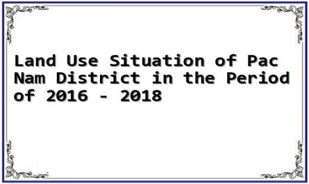
Source: Pac Nam District Statistical Yearbook, 2018
Over the past 3 years, the land use situation of the district has not changed much. Agricultural and aquatic land has not changed significantly, with an average increase of 0.11% over the past 3 years. The area of agricultural land has tended to increase slowly over the past 3 years, with an increase of 5.54 hectares in 2018 compared to 2017, equivalent to an increase of 0.12%. The average increase over the past 3 years was 4.97 hectares, equivalent to an increase of 0.05%. The change in agricultural land area is mainly due to the increase in the area of grass land used for livestock farming (an average increase of 3.97%), and the increase in the area of rice land (an average increase of 1.43%). This trend is consistent with the district's orientation of focusing on livestock farming and land reclamation and restoration.
The forestry land area increased by 0.12% over the past 3 years. Of which, the protective forest land increased by an average of 0.21%; the production forest land increased by 0.04%. The reason is that the district has additional planning, implementing project 661 to increase the area of planted forests for production and protection, implementing long-term land allocation for forests to people, combined with local development policies, so the forestry land area increased.
Non-agricultural land has an increasing trend, with an average increase of 1.87% over the past 3 years. The increase in area is mainly due to increased residential land, population growth, and thus the demand for residential land also increases.
As a northern district of the northern mountainous province, Pac Nam is mainly hilly (there is still a lot of unused land) with different heights, and soil characteristics suitable for planting and tending grass. These characteristics give Pac Nam favorable potential for developing beef cattle farming.
2.1.2. Socio-economic conditions of Pac Nam district
2.1.2.1. Socio-economic development situation
Pac Nam district's economy is mainly based on agricultural and forestry production:
- Regarding cultivation: the main crops are food crops such as rice, corn, cassava... short-term industrial crops include soybeans, in addition, vegetables and beans of all kinds are grown to supply the market.
- Regarding livestock: livestock development in the district includes livestock farming such as: buffalo, cows, and poultry farming: chickens, ducks. In addition, there are also some households raising honey bees and raising fish, contributing to job creation and increasing income.
- Regarding forestry: current production in the district mainly involves planting forests and protecting natural protective forests, because the current planted forests in the district have not yet reached the exploitation stage, so there is no economic income from the forests.
- Other economic sectors: currently the district's economic sector still focuses mainly on agricultural and forestry production, service sectors exist but are still on a small scale.
During the 2015-2020 term, Pac Nam District Party Committee focused on leading and directing the government, socio-political organizations and people to promote internal strength, effectively use resources to invest in building infrastructure, promote the application of science and technology in production and boldly shift the structure of crops and livestock, build economic models, and effectively implement policies to ensure social security.
2.1.2.2. Population - labor and employment situation
Pac Nam had a population of 32,414 people in 2018, of which the agricultural population accounted for 93% of the total population of the district. The average population density was 70.55 people/km2 ( Department of Labor, Invalids and Social Affairs of Pac Nam district (2017, 2018)). Pac Nam is a mountainous district, so the population density is low and the population is sparsely distributed. The population lives mainly on agriculture, the diversity of occupations in the district is low compared to other districts in the province.
The total number of households in the district is 5,452, of which agricultural households account for 95.27%, equivalent to 5,194 households; the main labor force of Pac Nam district is agricultural workers with a total of 14,144 people, accounting for 91.52% (Department of Labor, Invalids and Social Affairs of Pac Nam district (2017, 2018)). Over the past 3 years, the number of households participating in service, trade, industry and construction activities has not increased significantly (an average increase of only 1.27%), which proves that the structural shift between years towards a decrease in the proportion of agricultural labor and an increase in the proportion of industrial and service labor is still slow, not consistent with the economic development trend of the country.
The poverty rate is very high compared to the whole country. In 2017, the poverty rate was 42.57%, in 2018, the poverty rate was 38.95%, a decrease of 3.62% compared to 2017. Therefore, developing agriculture in a spearhead direction is extremely necessary, especially developing livestock and researching output for beef cattle to help livestock farmers achieve higher economic efficiency.
The population situation of the district is shown in detail in table 2.3.
Table 2.3. Population and labor situation of Pac Nam district in the period 2016 - 2018
TT
Year Target | Unit | 2016 | 2017 | 2018 | Compare (%) | ||
Year 2017/ 2016 | Year 2018/ 2017 | ||||||
1 | Total households | Household | 6,849 | 6,899 | 7,132 | 100.73 | 103.38 |
2 | Total population | Mouth | 32,703 | 33,114 | 33,414 | 101.26 | 100.91 |
3 | Total number of employees in age | Labor | 20,389 | 21,590 | 20,206 | 105.89 | 93.59 |
4 | Average household | Mouth/ household | 4.7 | 4.8 | 4.7 | 100.63 | 97.71 |
5 | Average labor/household | Labor/household | 2.98 | 3.13 | 2.83 | ||
6 | Population density | People/ km 2 | 69 | 70 | 70 | ||
(Source: Department of Labor, Invalids and Social Affairs of Pac Nam district, 2018)
According to statistics, ethnic minorities in the district are purely agricultural workers, most households live mainly on agricultural production, the whole district currently has 20,206 people of working age, accounting for 61.37% of the total population of the district. The labor structure between sectors and regions is different:
Agricultural workers: 17,989 people, accounting for 86.2% of the total number of workers working in economic sectors.
Industrial, handicraft and construction workers: 584 people, accounting for 2.8% of the workforce working in economic sectors.
Trade and service workers: 2,296 people, accounting for 11% of the total number of workers in economic sectors.
2.1.2.3. Infrastructure
Road system: Pac Nam has a total road length of 37km along the 258b axis. In recent years, the inter-district and inter-commune road network has been continuously opened, repaired and upgraded. The rural traffic system has been invested in and expanded in recent years, following the principle of people contributing and managing together. However, in general, the road system still faces many complex difficulties due to the terrain characteristics, especially in the rainy season, it is often blocked by landslides and underground systems, spillways and high flood waters.
The district's irrigation system is mostly small and low-scale. By 2017, the district had over 90 medium and small irrigation projects, meeting the irrigation water needs for over 50% of the district's total rice area.
Power grid system: The whole district has 30 transformer stations with a total capacity of 180KVA. In 2017, the electricity industry supplied nearly 2 million KW. More than 90% of households use the national grid. The district's rural power grid is currently being invested in construction and consolidation, the remaining households are still enjoying the state's policy of providing kerosene for lighting.
Regarding education: The whole district has 29 schools, including: 10 kindergartens; 10 primary schools; 6 junior high schools; 7 junior high schools; 1 high school. Regarding facilities, schools have not been invested in synchronously, most schools do not have libraries or laboratories; the number of temporary classrooms accounts for over 40%.
Regarding culture: 100% of communes have cultural post offices and cultural houses. Every year, over 70% of families achieve the title of cultural family.
Regarding health: The whole district has 01 district health center; 10 commune-level health stations, the level of medical skills and doctors basically meet the primary health care needs of the people.
In general, the district's infrastructure is not yet complete to serve the needs of production, life and circulation of goods. This is a difficulty for the consumption of beef.