Air humidity: high humidity, average relative humidity between months of the year reaches 84-87%, generally there is little difference between communes in the district.
Some extreme phenomena often occur in the district:
- Thunderstorms also appear in April and end in August, when thunderstorms are often accompanied by heavy rain.
- Drizzle usually appears in spring and ends in March and April of the following year.
- Frost usually appears at altitudes > 600m, the lower the temperature, the more days with frost, it rarely appears in low areas of the Red River valley.
- Hail appears in some places in late spring and early summer and is often accompanied by local thunderstorms and whirlwinds.
- Floods often occur in July and August every year, when rivers flood and encounter steep terrain and heavy rain, causing floods in low-lying areas.
- Drought is occurring locally and is at risk of increasing due to many causes.
In terms of hydrology , Van Yen district has a dense river network with the Red River system and two tributaries, the Hut and Thia rivers, and many other small streams.
The Red River originates from Yunnan, China, the section flowing through Yen Bai is 100 km long (many documents record 99 km or 105 km), the riverbed is 100 - 200m wide, with a lot of alluvium. The section of the Red River flowing through Van Yen is 70 km long. The tributaries of the Red River in the area are divided into the left bank and the right bank, creating a fairly rich hydrological regime. The riverbed here is quite wide with many alluvial flats. The erosion is large, so it provides a large amount of alluvium for the neighboring area.
Thia stream is the largest first-level tributary of the Red River, originating from Pu Luong mountain (Tram Tau) and flowing in the southwest - northeast direction, through Van Chan, pouring into the right bank of the Red River in Yen Hop commune. Hut stream is 140 km long, with a basin area of 632 km2 . Floodwater at Thia stream is quite large because the difference between the largest flow and the smallest flow is up to 480 times. Normally, the largest flow appears in September, accounting for 52% of the whole year in August, September, and October. Groundwater resources are quite abundant but unevenly distributed, in some places groundwater appears only a few dozen meters, in some places only a few meters. The underground water source is of good quality, and has not been polluted so far, so its reasonable exploitation will serve the development of agriculture, forestry, fishery, industry and services, including other fields.
c. Soil, biodiversity
According to the investigation results of the Forest Planning and Investigation Institute, the whole district has the following types of land:
Alluvial soil group : This soil group covers an area of 3,786.77 hectares, accounting for about 3% of the natural land area of the whole district, concentrated in the Red River basin, Thia stream, Hut stream and some other low-lying areas. The soil group is formed as a result of the alluvial sedimentation of rivers and streams. Depending on the composition of the sample, the areas have different physical and chemical properties. The important characteristic is large porosity, the organic matter content decreases with the depth of the soil, in addition to the disturbed A layer which is gray or soft or dark or has an H layer which accumulates organic matter, there are no other diagnostic layers . The ability to exploit this soil serves the purpose of growing rice, flowers and short-term industrial crops. Currently, this soil source has been almost fully exploited and used. [Table 2.1]
Table 2.1. Divergence of land use criteria in the planning of Van Yen district in 2014 and forecast for 2015 ( Unit: %)
STT
Target | 2014 | 2015 | |
1 | Agricultural land | 92.73 | 93.81 |
In there: | |||
1.1 | Rice land | 2.18 | 2.28 |
1.2 | Land for perennial crops | 2.99 | 5.67 |
1.3 | Protective forest land | 15.08 | 12.04 |
1.4 | Special use forest land | 10.42 | 11.79 |
1.5 | Production forest land | 49.62 | 51.23 |
1.6 | Aquaculture land | 0.16 | 0.22 |
2 | Non-agricultural land | 4.48 | 10.57 |
In there: | |||
2.1 | Land for construction of headquarters, public works | 0.01 | 0.02 |
2.2 | Defense land | 0.00 | 0.07 |
2.3 | Secure land | 0.00 | 0.00 |
2.4 | Industrial land | 0.01 | 0.20 |
2.5 | Land for production and business facilities | 0.02 | 0.06 |
2.6 | Land for production of ceramic construction materials | 0.03 | 0.57 |
2.7 | Land for mineral activities | 0.13 | 0.15 |
2.8 | Land of historical sites | 0.00 | 0.02 |
2.9 | Land for treatment and landfill of hazardous waste | 0.00 | 0.02 |
2.10 | Land of religion and belief | 0.01 | 0.01 |
2.11 | Cemetery land, cemetery | 0.12 | 0.13 |
2.12 | Land with dedicated water surface | 0.06 | 0.06 |
2.13 | Land for infrastructure development | 1.30 | 1.93 |
3 | Urban land | 0.57 | 0.06 |
4 | Nature reserve land | 10.42 | 11.79 |
Maybe you are interested!
-

 Regulations on Planning and Agricultural Land Use Plans
 -
 Evaluation of the implementation of new rural construction planning in Ba Vi district, Hanoi city in the period 2011 - 2020 - 1
 -
 Evaluation of Land Use Rights Mortgage Results at Vietnam Bank for Agriculture and Rural Development, Dien Bien Province Branch
 -
 Studying the current status of rural environment and proposing some solutions to implement environmental criteria in new rural construction in San Thang commune, Lai Chau city, Lai Chau province - 2
 -
 New Rural Construction Planning of Gia Cat Commune to 2020
(Source: Department of Agriculture and Rural Development of Van Yen district)
Hilly and mountainous soil group : This soil group has the largest area, accounting for over 80% of the natural area of the whole district. This is a soil group formed in steep hills and mountains, with a tropical monsoon climate. The basic characteristics of this soil group are acidic reaction, low base saturation, low activity, clay minerals are mainly kaolinite, with high accumulation of iron and aluminum, and relatively stable aggregate activity. It is divided into the following basic soil groups:
(1) Red-yellow soil group on metamorphic rocks and clay (fs) : this soil originates from shale, sandstone, mica and igneous rocks... the soil layer is thick, on average from 50-100cm, the mechanical composition is medium and heavy, often has a lumpy, granular structure... the humus content is quite good, total nitrogen is average, but substances such as nitrogen, phosphorus, as well as easily digestible are poor, the reaction is acidic to very acidic. This is a large area of soil and has good properties in hilly soils, currently being used effectively in agricultural and forestry production.
(2) Red-yellow humus soil group on acidic magma (Fha) : this type of soil is distributed at altitudes above 990 m. At this altitude, the feralit process has decreased. As the altitude increases, humidity increases, and temperature decreases, creating favorable conditions for humus accumulation. The soil has a surface layer with a fairly high humus and nitrogen content, poor in phosphorus but with a lot of potassium exchange. Due to being located on a steep terrain, the soil is eroded, with a lot of Ca2 +and Mg2 + .
(3) Light yellow soil on sandstone (Fq) : this type of soil is distributed in places with steep or gentle terrain, large erosion process, strong leaching, thin soil layer, mechanical composition from sand to sandy loam, loose structure, porosity from 40 - 45%, soil layer below 50 cm is bright yellow, loose sandy loam. In general, this is a bad type of soil, low natural fertility, very easy to turn into bare soil if there is no treatment.
protection method. This soil group is formed on high terrain, developed on acidic magma rocks, metamorphic rocks, limestone... thin soil layer mixed with many unfinished weathered rocks, mainly due to the leaching process, so the soil becomes increasingly thin.
Many places have exposed rocks and gravel. This soil group is generally thin in layer, distributed in areas with slopes >20o , accounting for about 1% of the district's natural area, suitable for growing industrial crops, fruit trees in low areas and afforestation to protect forests in higher mountainous terrain.
The land use situation of the district is reflected in Table 2.1.
Regarding biodiversity resources, according to preliminary investigation results, Na Hau nature reserve in particular, located in four communes in the south of the district (Dai Son, Na Hau, Phong Du Thuong, Mo Vang, 30km from the district center), has a fairly high species diversity. The whole district has 657 species belonging to 447 genera and 153 families in 5 branches: pine, pen, fern, gymnosperm and angiosperm. The biological composition in the district has a close relationship with 15 geographical factors of plants such as pantropical, tropical Asia, America, tropical grass, tropical Asia-Australia, tropical Asia-Africa, etc.
The terrestrial vertebrate fauna of the whole district has recorded 214 species, belonging to 80 families, 23 orders, including 53 species of mammals, 105 species of birds. 50 species of reptiles and 23 species of amphibians. Some rare species of animals need to be protected such as big-headed turtles, large flying squirrels, antelopes, northern striped deer, wild boars, deer, bears, gibbons, etc.
The rich and diverse flora and fauna are storing rare genetic resources in nature reserves, which are an important basis for developing ecotourism.
d. Mineral resources
According to the investigation results of the Department of Natural Resources and Environment of Yen Bai, minerals in Van Yen district are small and medium-sized, classified into the following groups:
Fuel minerals include brown coal mines in Hoang Thang, Tan Hop, Yen Hop, Xuan Ai, Dong Cuong, Dong An communes (reserves not yet assessed). Precious minerals include gold in Mo Vang, Phong Du Ha, Dai Son communes, mainly
Small and medium scale placer gold but currently being exploited and continued to be explored.
Metal minerals: Iron reserves are relatively large in My village, Dai Son is the largest mine in the province with large reserves. Iron ore in An Thinh commune - iron content 32-67%, reserves 1.5 million tons. Copper: currently being surveyed.
Non-metallic minerals include: Kaolin is the largest distributed in many communes in the district, Al 2 O 3 quality reaches 29-34%, Fe 2 O 3 reaches 0.8-4.2%, whiteness reaches 40
-70%, meets the standards for making paper filler and insulating powder; Phenphat belongs to Yen commune
Thai reserves 25,000 tons; Graphite is in Trai Hut and Mau A areas, of which Bac Mau A mine is the largest in the province with reserves of about 141,799 tons. Rare earth in An Phu commune, small scale, reserves assessed at level 1 and level 2 are 17.84 tons.
Construction materials are quite abundant, including: Limestone and marble: generally of good quality, capable of being exploited as construction materials, cement production and industrial crushed limestone for export. Brick and tile clay in the town areas of Mau A, Trai Hut (An Binh), Yen Hop, Phong Du Thuong, Mau Dong, Dong An, Dong Cuong: producing good quality bricks and tiles. Sand and gravel are concentrated in river basins in the communes of Mau A, An Thinh, Yen Hop. Lam Giang, An Binh, Dong Cuong...
In recent years, although mineral exploitation has not been large, it has contributed significantly to increasing local revenue.
2.1.2. Socio-economic factors
2.1.2.1. Population, ethnicity
a) Population size
(Source: District Population and Family Planning Office )
Van Yen 2014)
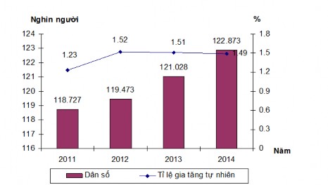
Figure 2.2. Average population and natural population growth rate of Van Yen district over the years 2011 - 2014
The district's population in 2014 was 122,873 people. According to the chart above, we multiply
The population of Van Yen district increased every year from 2011 to 2014.
more than 4,000 people and increasing steadily, on average each year increasing about 1,000 people, especially from 2012-2013 increasing sharply with more than 1,500 people. The natural increase rate increased rapidly in 2011-2012, increasing by 0.29%, then due to policies it gradually decreased. (Figure 2.2).
Population distribution is uneven, concentrated
mainly in the region
town
Model
A, because this is the economic and cultural center of the district .
like a place where people
speed
minority or even a developing country rather than a concentrated population
middle school student
like Na Hau , Xuan Tam, Mo Vang...
The population in the district lives in 26 communes and one town, with an average density of 83 people/km2 , but the distribution is uneven. Mau A town is the largest with an average of 1253 people/km2 , while the highland communes have larger areas but are sparsely populated, such as Phong Du Thuong commune with an average of 23 people, Xuan Tam commune with 53 people, and Na Hau commune with 28 people. In 2014, the working-age population of the district was 64,191 people, accounting for about 53% of the population.
b) Ethnicity
The population here is mainly Kinh people ( 61.5 %) besides that there are also ethnic minorities .
ethnic groups
where ethnic minorities such as Tay, Dao... live [Figure 2.3. ]
The district has 12 ethnic groups, including the main ethnic groups. The cultural community of ethnic groups in the province with their own cultural features and identities has formed a diverse and rich culture, with many unique and profound humanistic features. This is a unique feature to develop tourism, creating diverse farming practices. Due to the complex terrain, limited intellectual level, uneven distribution, essential infrastructure works have not been guaranteed.
2.1.2.2. Technical facilities
● Transportation
- Roads: The total length of roads in the district is 842.9km, including:
+ Hanoi - Lao Cai Expressway, 90 km through Yen Bai, has a toll station in An Thinh Commune (in Mau A town).
+ Provincial roads include 4 routes: Yen Bai - Khe Sang 65km long, Quy Mong - Dong An - Que Phong 33km long; Mau A - Tan Nguyen 17km long, An Binh - Lang Khay 23km long, roads meeting level 4 and level 5 standards, of which 72km is asphalt road, 59km is graded road.
+ District roads have 25 routes meeting level 5, level A, B standards. Of which, concrete roads are 15.4km, asphalt roads are 30.8km, and aggregate roads are 24.8km.