Editor: Phan Quoc Chinh
Instructor: Assoc.Prof.Dr. Tran Viet Khanh
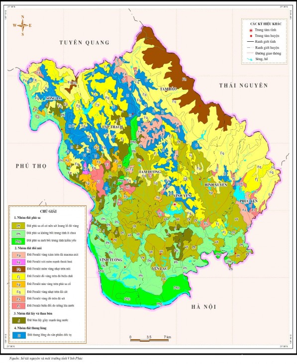
Figure 2.3. Soil map of Vinh Phuc province
Table 2.2. Current land use status of Vinh Phuc province in 2016
Soil type
Area (ha) | Structure (%) | |
Total natural area | 123,515 | 100.0 |
Agricultural land 1. Agricultural land 2. Forestry land 3. Aquaculture land 4. Other agricultural land | 92,823 55,676 32,285 4,480 382 | 75.15 45.08 26.13 3.63 0.31 |
Non-agricultural land 1. Residential land 2. Specialized land 3. Religious land 4. Cemetery land 5. Rivers, streams and specialized water surfaces 6. Other non-agricultural land | 29,733 7,747 17,248 193 668 3,857 19 | 24.07 6.27 13.96 0.16 0.54 3.12 0.02 |
Unused land 1. Unused flat land 2. Unused hilly land 3. Rocky mountains without trees | 959 386 442 132 | 0.78 0.31 0.36 0.11 |
Maybe you are interested!
-
 Overview of Natural Conditions, Socio-Economics and Current Land Use Status in Lai Chau City, Lai Chau Province
 -
 Identify Rating Levels and Rating Scales
zt2i3t4l5ee
zt2a3gstourism,quan lan,quang ninh,ecology,ecotourism,minh chau,van don,geography,geographical basis,tourism development,science
zt2a3ge
zc2o3n4t5e6n7ts
of the islanders. Therefore, this indicator will be divided into two sub-indicators:
a1. Natural tourism attractiveness a2. Cultural tourism attractiveness
b. Tourist capacity
The two island communes in Quan Lan have different capacities to receive tourists. Minh Chau Commune is home to many standard hotels and resorts, attracting high-income domestic and international tourists. Meanwhile, Quan Lan Commune has many motels mainly built and operated by local people, so the scale and quality are not high, and will be suitable for ordinary tourists such as students.
c. Time of exploitation of Quan Lan Island Commune:
Quan Lan tourism is seasonal due to weather and climate conditions and festivals only take place on certain days of the year, specifically in spring. In Quan Lan commune, the period from April to June and from September to November is considered the best time to visit Quan Lan because the cultural tourism activities are mainly associated with festivals taking place during this time.
Minh Chau island commune:
Tourism exploitation time is all year round, because this is a place with a number of tourist attractions with diverse ecosystems such as Bai Tu Long National Park Research Center, Tram forest, Turtle Laying Beach, so besides coming to the beach for tourism and vacation in the summer, Minh Chau will attract research groups to come for tourism combined with research at other times of the year.
d. Sustainability
The sustainability of ecotourism sites in Quan Lan and Minh Chau communes depends on the sensitivity of the ecosystems to climate changes.
landscape. In general, these tourist destinations have a fairly high level of sustainability, because they are natural ecosystems, planned and protected. However, if a large number of tourists gather at certain times, it can exceed the carrying capacity and affect the sustainability of the environment (polluted beaches, damaged trees, animals moving away from their habitats, etc.), then the sustainability of the above ecosystems (natural ecosystems, human ecosystems) will also be affected and become less sustainable.
e. Location and accessibility
Both island communes have ports to take tourists to visit from Van Don wharf:
- Quan Lan – Van Don traffic route:
Phuc Thinh – Viet Anh high-speed boat and Quang Minh high-speed boat, depart at 8am and 2pm from Van Don to Quan Lan, and at 7am and 1pm from Quan Lan to Van Don. There are also wooden boats departing at 7am and 1pm.
- Van Don - Minh Chau traffic route:
Chung Huong high-speed train, Minh Chau train, morning 7:30 and afternoon 13:30 from Van Don to Minh Chau, morning 6:30 and afternoon 13:00 from Minh Chau to Van Don.
f. Infrastructure
Despite receiving investment attention, the issue of infrastructure and technical facilities for tourism on Quan Lan Island is still an issue that needs to be resolved because it has a direct impact on the implementation of ecotourism activities. The minimum conditions for serving tourists such as accommodation, electricity, water, communication, especially medical services, and security work need to be given top priority. Ecotourism spots in Minh Chau commune are assessed to have better infrastructure and technical facilities for tourism because there are quite complete and synchronous conditions for serving tourists, meeting many needs of domestic and foreign tourists.
3.2.1.4. Determine assessment levels and assessment scales
Corresponding to the levels of each criterion, the index is the score of those levels in the order of 4, 3, 2, 1 decreasing according to the standard of each level: very attractive (4), attractive (3), average (2), less attractive (1).
3.2.1.5. Determining the coefficients of the criteria
For the assessment of DLST in the two communes of Quan Lan and Minh Chau islands, the students added evaluation coefficients to show the importance of the criteria and indicators as follows:
Coefficient 3 with criteria: Attractiveness, Exploitation time. These are the 2 most important criteria for attracting tourists to tourism in general and eco-tourism in particular, so they have the highest coefficient.
Coefficient 2 with criteria: Capacity, Infrastructure, Location and accessibility . Because the assessment area is an island commune of Van Don district, the above criteria are selected by the author with appropriate coefficients at the average level.
Coefficient 1 with criteria: Sustainability. Quan Lan has natural and human-made ecotourism sites, with high biodiversity and little impact from local human factors. Most of the ecotourism sites are still wild, so they are highly sustainable.
3.2.1.6. Results of DLST assessment on Quan Lan island
a. Assessment of the potential for natural tourism development
For Minh Chau commune:
+ Natural tourism attractiveness is determined to be very attractive (4 points) and the most important coefficient (coefficient 3), so the score of the Attractiveness criterion is 4 x 3 = 12.
+ Capacity is determined as average (2 points) and the coefficient is quite important (coefficient 2), then the score of Capacity criterion is 2 x 2 = 4.
+ Exploitation time is long (4 points), the most important coefficient (coefficient 3) so the score of the Exploitation time criterion is 4 x 3 = 12.
+ Sustainability is determined as sustainable (4 points), the important coefficient is the average coefficient (coefficient 1), so the score of the Sustainability criterion is 4 x 1 = 4 points
+ Location and accessibility are determined to be quite favorable (2 points), the coefficient is quite important (coefficient 2), the criterion score is 2 x 2 = 4 points.
+ Infrastructure is assessed as good (3 points), the coefficient is quite important (coefficient 2), then the score of the Infrastructure criterion is 3 x 2 = 6 points.
The total score for evaluating DLST in Minh Chau commune according to 6 evaluation criteria is determined as: 12 + 4 + 12 + 4 + 4 + 6 = 42 points
Similar assessment for Quan Lan commune, we have the following table:
Table 3.3: Assessment of the potential for natural ecotourism development in Quan Lan and Minh Chau communes
Attractiveness of self-tourismof course
Capacity
Mining time
Sustainability
Location and accessibility
Infrastructure
Result
Point
DarkMulti
Point
DarkMulti
Point
DarkMulti
Point
DarkMulti
Point
DarkMulti
Point
DarkMulti
CommuneMinh Chau
12
12
4
8
12
12
4
4
4
8
6
8
42/52
Quan CommuneLan
6
12
6
8
9
12
4
4
4
8
4
8
33/52
b. Assessment of the potential for humanistic tourism development
For Quan Lan commune:
+ The attractiveness of human tourism is determined to be very attractive (4 points) and the most important coefficient (coefficient 3), so the score of the Attractiveness criterion is 4 x 3 = 12.
+ Capacity is determined to be large (3 points) and the coefficient is quite important (coefficient 2), then the score of the Capacity criterion is 3 x 2 = 6.
+ Mining time is average (3 points), the most important coefficient (coefficient 3) so the score of the Mining time criterion is 3 x 3 = 9.
+ Sustainability is determined as sustainable (4 points), the important coefficient is the average coefficient (coefficient 1), so the score of the Sustainability criterion is 4 x 1 = 4 points.
+ Location and accessibility are determined to be quite favorable (2 points), the coefficient is quite important (coefficient 2), the criterion score is 2 x 2 = 4 points.
+ Infrastructure is rated as average (2 points), the coefficient is quite important (coefficient 2), then the score of the Infrastructure criterion is 2 x 2 = 4 points.
The total score for evaluating DLST in Quan Lan commune according to 6 evaluation criteria is determined as: 12 + 6 + 6 + 4 + 4 + 4 = 36 points.
Similar assessment with Minh Chau commune we have the following table:
Table 3.4: Assessment of the potential for developing humanistic eco-tourism in Quan Lan and Minh Chau communes
Attractiveness of human tourismliterature
Capacity
Mining time
Sustainability
Location and accessibility
Infrastructure
Result
Point
DarkMulti
Point
DarkMulti
Point
DarkMulti
Point
DarkMulti
Point
DarkMulti
Point
DarkMulti
Quan CommuneLan
12
12
6
8
9
12
4
4
4
8
4
8
39/52
Minh CommuneChau
6
12
4
8
12
12
4
4
4
8
6
8
36/52
Basically, both Minh Chau and Quan Lan localities have quite favorable conditions for developing ecotourism. However, Quan Lan commune has more advantages to develop ecotourism in a humanistic direction, because this is an area with many famous historical relics such as Quan Lan Communal House, Quan Lan Pagoda, Temple worshiping the hero Tran Khanh Du, ... along with local festivals held annually such as the wind praying ceremony (March 15), Quan Lan festival (June 10-19); due to its location near the port and long exploitation time, the beaches in Quan Lan commune (especially Quan Lan beach) are no longer hygienic and clean to ensure the needs of tourists coming to relax and swim; this is also an area with many beautiful landscapes such as Got Beo wind pass, Ong Phong head, Voi Voi cave, but the ability to access these places is still very limited (dirt hill road, lots of gravel and rocks), especially during rainy and windy times; In addition, other natural resources such as mangrove forests and sea worms have not been really exploited for tourism purposes and ecotourism development. On the contrary, Minh Chau commune has more advantages in developing ecotourism in the direction of natural tourism, this is an area with diverse ecosystems such as at Rua De Beach, Bai Tu Long National Park Conservation Center...; Minh Chau beach is highly appreciated for its natural beauty and cleanliness, ranked in the top ten most beautiful beaches in Vietnam; Minh Chau commune is also home to Tram forest with a large area and a purity of up to 90%, suitable for building bridges through the forest (a very effective type of natural ecotourism currently applied by many countries) for tourists to sightsee, as well as for the purpose of studying and researching.
Figure 3.1: Thenmala Forest Bridge (India) Source: https://www.thenmalaecotourism.com/(August 21, 2019)
3.2.2. Using SWOT matrix to evaluate Quan Lan island tourism
General assessment of current tourism activities of Quan Lan island is shown through the following SWOT matrix:
Table 3.5: SWOT matrix evaluating tourism activities on Quan Lan island
Internal agent
Strengths- There is a lot of potential for tourism development, especially natural ecotourism and humanistic ecotourism.- The unskilled labor force is relatively abundant.- resource environmentunpolluted, still
Weaknesses- Poorly developed infrastructure, especially traffic routes to tourist destinations on the island.- The team of professional staff is still weak.- Tourism products in general
quite wild, originalintact
general and DLST in particularalone is monotonous.
External agents
Opportunity- Tourism is a key industry in the socio-economic development strategy of the province and Van Don economic zone.- Quan Lan was selected as a pilot area for eco-tourism development within the framework of the green growth project between Quang Ninh province and the Japanese organization JICA.- The flow of tourists and especially ecotourism in the world tends toincreasing
Challenge- Weather and climate change abnormally.- Competition in tourism products is increasingly fierce, especially with other localities in the province such as Ha Long, Mong Cai...- Awareness of tourists, especially domestic tourists, about ecotourism and nature conservation is not high.
Through summary analysis using SWOT matrix we see that:
To exploit strengths and take advantage of opportunities, it is necessary to:
- Diversify products and service types (build more tourism routes aimed at specific needs of tourists: experiential tourism immersed in nature, spiritual cultural tourism...)
- Effective exploitation of resources and differentiated products (natural resources and human resources)
div.maincontent .p { color: black; font-family:"Times New Roman", serif; font-style: normal; font-weight: normal; text-decoration: none; font-size: 14pt; margin:0pt; } div.maincontent p { color: black; font-family:"Times New Roman", serif; font-style: normal; font-weight: normal; text-decoration: none; font-size: 14pt; margin:0pt; } div.maincontent .s1 { color: black; font-family:"Times New Roman", serif; font-style: normal; font-weight: normal; text-decoration: none; font-size: 13pt; } div.maincontent .s2 { color: black; font-family:"Times New Roman", serif; font-style: normal; font-weight: normal; text-decoration: none; font-size: 13pt; } div.maincontent .s3 { color: #0D0D0D; font-family:"Times New Roman", serif; font-style: normal; font-weight: bold; text-decoration: none; font-size: 14pt; } div.maincontent .s4 { color: black; font-family:"Times New Roman", serif; font-style: italic; font-weight: normal; text-decoration: none; font-size: 14pt; } div.maincontent .s5 { color: black; font-family:"Times New Roman", serif; font-style: italic; font-weight: bold; text-decoration: none; font-size: 14pt; } div.maincontent .s6 { color: black; font-family:"Times New Roman", serif; font-style: italic; font-weight: normal; text-decoration: none; font-size: 14pt; vertical-align: -3pt; } div.maincontent .s7 { color: black; font-family:"Times New Roman", serif; font-style: italic; font-weight: normal; text-decoration: none; font-size: 14pt; vertical-align: -2pt; } div.maincontent .s8 { color: black; font-family:"Times New Roman", serif; font-style: italic; font-weight: normal; text-decoration: none; font-size: 14pt; vertical-align: -1pt; } div.maincontent .s9 { color: black; font-family:"Times New Roman", serif; font-style: normal; font-weight: normal; text-decoration: none; font-size: 14pt; } div.maincontent .s10 { color: black; font-family:"Times New Roman", serif; font-style: normal; font-weight: bold; text-decoration: none; font-size: 14pt; } div.maincontent .s11 { color: black; font-family:"Times New Roman", serif; font-style: normal; font-weight: normal; text-decoration: none; font-size: 14pt; } div.maincontent .s12 { color: black; font-family:Symbol, serif; font-style: normal; font-weight: normal; text-decoration: none; font-size: 14pt; } div.maincontent .s13 { color: black; font-family:Wingdings; font-style: normal; font-weight: normal; text-decoration: none; font-size: 14pt; } div.maincontent .s14 { color: black; font-family:"Times New Roman", serif; font-style: normal; font-weight: normal; text-decoration: none; font-size: 9pt; vertical-align: 5pt; } div.maincontent .s15 { color: black; font-family:"Times New Roman", serif; font-style: normal; font-weight: normal; text-decoration: none; font-size: 9pt; vertical-align: 5pt; } div.maincontent .s16 { color: black; font-family:Cambria, serif; font-style: italic; font-weight: normal; text-decoration: none; font-size: 14pt; } div.maincontent .s17 { color: #080808; font-family:"Times New Roman", serif; font-style: normal; font-weight: bold; text-decoration: none; font-size: 14pt; } div.maincontent .s18 { color: #080808; font-family:"Times New Roman", serif; font-style: normal; font-weight: normal; text-decoration: none; font-size: 14pt; } div.maincontent .s19 { color: black; font-family:"Times New Roman", serif; font-style: normal; font-weight: normal; text-decoration: none; font-size: 11pt; } div.maincontent .s20 { color: black; font-family:"Times New Roman", serif; font-style: normal; font-weight: normal; text-decoration: none; font-size: 10pt; } div.maincontent .s21 { color: black; font-family:"Times New Roman", serif; font-style: normal; font-weight: bold; text-decoration: none; font-size: 11pt; } div.maincontent .s22 { color: black; font-family:"Times New Roman", serif; font-style: normal; font-weight: normal; text-decoration: none; font-size: 11pt; } div.maincontent .s23 { color: black; font-family:"Times New Roman", serif; font-style: italic; font-weight: normal; text-decoration: none; font-size: 14pt; } div.maincontent .s24 { color: #212121; font-family:"Times New Roman", serif; font-style: normal; font-weight: normal; tex
Identify Rating Levels and Rating Scales
zt2i3t4l5ee
zt2a3gstourism,quan lan,quang ninh,ecology,ecotourism,minh chau,van don,geography,geographical basis,tourism development,science
zt2a3ge
zc2o3n4t5e6n7ts
of the islanders. Therefore, this indicator will be divided into two sub-indicators:
a1. Natural tourism attractiveness a2. Cultural tourism attractiveness
b. Tourist capacity
The two island communes in Quan Lan have different capacities to receive tourists. Minh Chau Commune is home to many standard hotels and resorts, attracting high-income domestic and international tourists. Meanwhile, Quan Lan Commune has many motels mainly built and operated by local people, so the scale and quality are not high, and will be suitable for ordinary tourists such as students.
c. Time of exploitation of Quan Lan Island Commune:
Quan Lan tourism is seasonal due to weather and climate conditions and festivals only take place on certain days of the year, specifically in spring. In Quan Lan commune, the period from April to June and from September to November is considered the best time to visit Quan Lan because the cultural tourism activities are mainly associated with festivals taking place during this time.
Minh Chau island commune:
Tourism exploitation time is all year round, because this is a place with a number of tourist attractions with diverse ecosystems such as Bai Tu Long National Park Research Center, Tram forest, Turtle Laying Beach, so besides coming to the beach for tourism and vacation in the summer, Minh Chau will attract research groups to come for tourism combined with research at other times of the year.
d. Sustainability
The sustainability of ecotourism sites in Quan Lan and Minh Chau communes depends on the sensitivity of the ecosystems to climate changes.
landscape. In general, these tourist destinations have a fairly high level of sustainability, because they are natural ecosystems, planned and protected. However, if a large number of tourists gather at certain times, it can exceed the carrying capacity and affect the sustainability of the environment (polluted beaches, damaged trees, animals moving away from their habitats, etc.), then the sustainability of the above ecosystems (natural ecosystems, human ecosystems) will also be affected and become less sustainable.
e. Location and accessibility
Both island communes have ports to take tourists to visit from Van Don wharf:
- Quan Lan – Van Don traffic route:
Phuc Thinh – Viet Anh high-speed boat and Quang Minh high-speed boat, depart at 8am and 2pm from Van Don to Quan Lan, and at 7am and 1pm from Quan Lan to Van Don. There are also wooden boats departing at 7am and 1pm.
- Van Don - Minh Chau traffic route:
Chung Huong high-speed train, Minh Chau train, morning 7:30 and afternoon 13:30 from Van Don to Minh Chau, morning 6:30 and afternoon 13:00 from Minh Chau to Van Don.
f. Infrastructure
Despite receiving investment attention, the issue of infrastructure and technical facilities for tourism on Quan Lan Island is still an issue that needs to be resolved because it has a direct impact on the implementation of ecotourism activities. The minimum conditions for serving tourists such as accommodation, electricity, water, communication, especially medical services, and security work need to be given top priority. Ecotourism spots in Minh Chau commune are assessed to have better infrastructure and technical facilities for tourism because there are quite complete and synchronous conditions for serving tourists, meeting many needs of domestic and foreign tourists.
3.2.1.4. Determine assessment levels and assessment scales
Corresponding to the levels of each criterion, the index is the score of those levels in the order of 4, 3, 2, 1 decreasing according to the standard of each level: very attractive (4), attractive (3), average (2), less attractive (1).
3.2.1.5. Determining the coefficients of the criteria
For the assessment of DLST in the two communes of Quan Lan and Minh Chau islands, the students added evaluation coefficients to show the importance of the criteria and indicators as follows:
Coefficient 3 with criteria: Attractiveness, Exploitation time. These are the 2 most important criteria for attracting tourists to tourism in general and eco-tourism in particular, so they have the highest coefficient.
Coefficient 2 with criteria: Capacity, Infrastructure, Location and accessibility . Because the assessment area is an island commune of Van Don district, the above criteria are selected by the author with appropriate coefficients at the average level.
Coefficient 1 with criteria: Sustainability. Quan Lan has natural and human-made ecotourism sites, with high biodiversity and little impact from local human factors. Most of the ecotourism sites are still wild, so they are highly sustainable.
3.2.1.6. Results of DLST assessment on Quan Lan island
a. Assessment of the potential for natural tourism development
For Minh Chau commune:
+ Natural tourism attractiveness is determined to be very attractive (4 points) and the most important coefficient (coefficient 3), so the score of the Attractiveness criterion is 4 x 3 = 12.
+ Capacity is determined as average (2 points) and the coefficient is quite important (coefficient 2), then the score of Capacity criterion is 2 x 2 = 4.
+ Exploitation time is long (4 points), the most important coefficient (coefficient 3) so the score of the Exploitation time criterion is 4 x 3 = 12.
+ Sustainability is determined as sustainable (4 points), the important coefficient is the average coefficient (coefficient 1), so the score of the Sustainability criterion is 4 x 1 = 4 points
+ Location and accessibility are determined to be quite favorable (2 points), the coefficient is quite important (coefficient 2), the criterion score is 2 x 2 = 4 points.
+ Infrastructure is assessed as good (3 points), the coefficient is quite important (coefficient 2), then the score of the Infrastructure criterion is 3 x 2 = 6 points.
The total score for evaluating DLST in Minh Chau commune according to 6 evaluation criteria is determined as: 12 + 4 + 12 + 4 + 4 + 6 = 42 points
Similar assessment for Quan Lan commune, we have the following table:
Table 3.3: Assessment of the potential for natural ecotourism development in Quan Lan and Minh Chau communes
Attractiveness of self-tourismof course
Capacity
Mining time
Sustainability
Location and accessibility
Infrastructure
Result
Point
DarkMulti
Point
DarkMulti
Point
DarkMulti
Point
DarkMulti
Point
DarkMulti
Point
DarkMulti
CommuneMinh Chau
12
12
4
8
12
12
4
4
4
8
6
8
42/52
Quan CommuneLan
6
12
6
8
9
12
4
4
4
8
4
8
33/52
b. Assessment of the potential for humanistic tourism development
For Quan Lan commune:
+ The attractiveness of human tourism is determined to be very attractive (4 points) and the most important coefficient (coefficient 3), so the score of the Attractiveness criterion is 4 x 3 = 12.
+ Capacity is determined to be large (3 points) and the coefficient is quite important (coefficient 2), then the score of the Capacity criterion is 3 x 2 = 6.
+ Mining time is average (3 points), the most important coefficient (coefficient 3) so the score of the Mining time criterion is 3 x 3 = 9.
+ Sustainability is determined as sustainable (4 points), the important coefficient is the average coefficient (coefficient 1), so the score of the Sustainability criterion is 4 x 1 = 4 points.
+ Location and accessibility are determined to be quite favorable (2 points), the coefficient is quite important (coefficient 2), the criterion score is 2 x 2 = 4 points.
+ Infrastructure is rated as average (2 points), the coefficient is quite important (coefficient 2), then the score of the Infrastructure criterion is 2 x 2 = 4 points.
The total score for evaluating DLST in Quan Lan commune according to 6 evaluation criteria is determined as: 12 + 6 + 6 + 4 + 4 + 4 = 36 points.
Similar assessment with Minh Chau commune we have the following table:
Table 3.4: Assessment of the potential for developing humanistic eco-tourism in Quan Lan and Minh Chau communes
Attractiveness of human tourismliterature
Capacity
Mining time
Sustainability
Location and accessibility
Infrastructure
Result
Point
DarkMulti
Point
DarkMulti
Point
DarkMulti
Point
DarkMulti
Point
DarkMulti
Point
DarkMulti
Quan CommuneLan
12
12
6
8
9
12
4
4
4
8
4
8
39/52
Minh CommuneChau
6
12
4
8
12
12
4
4
4
8
6
8
36/52
Basically, both Minh Chau and Quan Lan localities have quite favorable conditions for developing ecotourism. However, Quan Lan commune has more advantages to develop ecotourism in a humanistic direction, because this is an area with many famous historical relics such as Quan Lan Communal House, Quan Lan Pagoda, Temple worshiping the hero Tran Khanh Du, ... along with local festivals held annually such as the wind praying ceremony (March 15), Quan Lan festival (June 10-19); due to its location near the port and long exploitation time, the beaches in Quan Lan commune (especially Quan Lan beach) are no longer hygienic and clean to ensure the needs of tourists coming to relax and swim; this is also an area with many beautiful landscapes such as Got Beo wind pass, Ong Phong head, Voi Voi cave, but the ability to access these places is still very limited (dirt hill road, lots of gravel and rocks), especially during rainy and windy times; In addition, other natural resources such as mangrove forests and sea worms have not been really exploited for tourism purposes and ecotourism development. On the contrary, Minh Chau commune has more advantages in developing ecotourism in the direction of natural tourism, this is an area with diverse ecosystems such as at Rua De Beach, Bai Tu Long National Park Conservation Center...; Minh Chau beach is highly appreciated for its natural beauty and cleanliness, ranked in the top ten most beautiful beaches in Vietnam; Minh Chau commune is also home to Tram forest with a large area and a purity of up to 90%, suitable for building bridges through the forest (a very effective type of natural ecotourism currently applied by many countries) for tourists to sightsee, as well as for the purpose of studying and researching.
Figure 3.1: Thenmala Forest Bridge (India) Source: https://www.thenmalaecotourism.com/(August 21, 2019)
3.2.2. Using SWOT matrix to evaluate Quan Lan island tourism
General assessment of current tourism activities of Quan Lan island is shown through the following SWOT matrix:
Table 3.5: SWOT matrix evaluating tourism activities on Quan Lan island
Internal agent
Strengths- There is a lot of potential for tourism development, especially natural ecotourism and humanistic ecotourism.- The unskilled labor force is relatively abundant.- resource environmentunpolluted, still
Weaknesses- Poorly developed infrastructure, especially traffic routes to tourist destinations on the island.- The team of professional staff is still weak.- Tourism products in general
quite wild, originalintact
general and DLST in particularalone is monotonous.
External agents
Opportunity- Tourism is a key industry in the socio-economic development strategy of the province and Van Don economic zone.- Quan Lan was selected as a pilot area for eco-tourism development within the framework of the green growth project between Quang Ninh province and the Japanese organization JICA.- The flow of tourists and especially ecotourism in the world tends toincreasing
Challenge- Weather and climate change abnormally.- Competition in tourism products is increasingly fierce, especially with other localities in the province such as Ha Long, Mong Cai...- Awareness of tourists, especially domestic tourists, about ecotourism and nature conservation is not high.
Through summary analysis using SWOT matrix we see that:
To exploit strengths and take advantage of opportunities, it is necessary to:
- Diversify products and service types (build more tourism routes aimed at specific needs of tourists: experiential tourism immersed in nature, spiritual cultural tourism...)
- Effective exploitation of resources and differentiated products (natural resources and human resources)
div.maincontent .p { color: black; font-family:"Times New Roman", serif; font-style: normal; font-weight: normal; text-decoration: none; font-size: 14pt; margin:0pt; } div.maincontent p { color: black; font-family:"Times New Roman", serif; font-style: normal; font-weight: normal; text-decoration: none; font-size: 14pt; margin:0pt; } div.maincontent .s1 { color: black; font-family:"Times New Roman", serif; font-style: normal; font-weight: normal; text-decoration: none; font-size: 13pt; } div.maincontent .s2 { color: black; font-family:"Times New Roman", serif; font-style: normal; font-weight: normal; text-decoration: none; font-size: 13pt; } div.maincontent .s3 { color: #0D0D0D; font-family:"Times New Roman", serif; font-style: normal; font-weight: bold; text-decoration: none; font-size: 14pt; } div.maincontent .s4 { color: black; font-family:"Times New Roman", serif; font-style: italic; font-weight: normal; text-decoration: none; font-size: 14pt; } div.maincontent .s5 { color: black; font-family:"Times New Roman", serif; font-style: italic; font-weight: bold; text-decoration: none; font-size: 14pt; } div.maincontent .s6 { color: black; font-family:"Times New Roman", serif; font-style: italic; font-weight: normal; text-decoration: none; font-size: 14pt; vertical-align: -3pt; } div.maincontent .s7 { color: black; font-family:"Times New Roman", serif; font-style: italic; font-weight: normal; text-decoration: none; font-size: 14pt; vertical-align: -2pt; } div.maincontent .s8 { color: black; font-family:"Times New Roman", serif; font-style: italic; font-weight: normal; text-decoration: none; font-size: 14pt; vertical-align: -1pt; } div.maincontent .s9 { color: black; font-family:"Times New Roman", serif; font-style: normal; font-weight: normal; text-decoration: none; font-size: 14pt; } div.maincontent .s10 { color: black; font-family:"Times New Roman", serif; font-style: normal; font-weight: bold; text-decoration: none; font-size: 14pt; } div.maincontent .s11 { color: black; font-family:"Times New Roman", serif; font-style: normal; font-weight: normal; text-decoration: none; font-size: 14pt; } div.maincontent .s12 { color: black; font-family:Symbol, serif; font-style: normal; font-weight: normal; text-decoration: none; font-size: 14pt; } div.maincontent .s13 { color: black; font-family:Wingdings; font-style: normal; font-weight: normal; text-decoration: none; font-size: 14pt; } div.maincontent .s14 { color: black; font-family:"Times New Roman", serif; font-style: normal; font-weight: normal; text-decoration: none; font-size: 9pt; vertical-align: 5pt; } div.maincontent .s15 { color: black; font-family:"Times New Roman", serif; font-style: normal; font-weight: normal; text-decoration: none; font-size: 9pt; vertical-align: 5pt; } div.maincontent .s16 { color: black; font-family:Cambria, serif; font-style: italic; font-weight: normal; text-decoration: none; font-size: 14pt; } div.maincontent .s17 { color: #080808; font-family:"Times New Roman", serif; font-style: normal; font-weight: bold; text-decoration: none; font-size: 14pt; } div.maincontent .s18 { color: #080808; font-family:"Times New Roman", serif; font-style: normal; font-weight: normal; text-decoration: none; font-size: 14pt; } div.maincontent .s19 { color: black; font-family:"Times New Roman", serif; font-style: normal; font-weight: normal; text-decoration: none; font-size: 11pt; } div.maincontent .s20 { color: black; font-family:"Times New Roman", serif; font-style: normal; font-weight: normal; text-decoration: none; font-size: 10pt; } div.maincontent .s21 { color: black; font-family:"Times New Roman", serif; font-style: normal; font-weight: bold; text-decoration: none; font-size: 11pt; } div.maincontent .s22 { color: black; font-family:"Times New Roman", serif; font-style: normal; font-weight: normal; text-decoration: none; font-size: 11pt; } div.maincontent .s23 { color: black; font-family:"Times New Roman", serif; font-style: italic; font-weight: normal; text-decoration: none; font-size: 14pt; } div.maincontent .s24 { color: #212121; font-family:"Times New Roman", serif; font-style: normal; font-weight: normal; tex -
 Research on current status and improvement of cropping system on coastal land of Thanh Hoa province - 19
 -
 Hoang Thanh Phuc (2009), "Research on Current Status and Solutions for Developing Scattered Forestry Planting in Thai Nguyen Province", Master's Thesis,
 -
 Assessment of the current status of land use rights mortgage activities at the Vietnam Bank for Agriculture and Rural Development, Dien Bien province branch - 2
Source: Department of Natural Resources and Environment of Vinh Phuc province [38]
2.1.7. Forests - Flora and fauna resources
Diversity of forest ecosystems, biological communities and species diversity, especially in Tam Dao National Park. As of 2016, Vinh Phuc province has 32,285 hectares of forestry land with a total forest area of 28,040.5 hectares, of which natural forests are 9,355.2 hectares and planted forests are 18,685.3 hectares. With the following forest types [41]:
- Lowland tropical evergreen, humid rainforest: distributed at an altitude of 700 m, occupying the majority of Tam Dao mountain range with multi-layered flora, closed canopy of evergreen broadleaf trees. Many species of trees have economic value such as: Chò chỉ, Giổi, Re, Trường mật.
- Low mountain subtropical humid evergreen closed forest: only found in Tam Dao range, distributed at altitudes of 800 m and above. Plants here include species of the re family, chestnut family, tea family, magnolia family, and sau sau family. From an altitude of 1,000 m and above, some species of gymnosperms appear such as: pine, po mu, bamboo pine, and kim giao.
- Dwarf forest on mountain tops: is a special subtype of evergreen, subtropical humid, medium mountain forests, formed on steep slopes, or high mountain tops with poor soil, lots of sun, wind, and fog. Therefore, the vegetation here is often low, small, and slow growing. The main plants are species of the Rhododendron, Rhizome, Chestnut, and Anise families.
- Bamboo forests: grow interspersed with other types of forests. At altitudes above 800 m, there are species such as: bamboo, sát gai; at altitudes of 500 m - 800 m, there is giang, below 500 m, there is nua.
- Forest recovered after slash-and-burn farming: found in the buffer zone of Tam Dao National Park with plant species such as: dung, men tang, amer, ba soi.
- Planted forests: at an altitude of 200 m - 600 m, distributed in the Northwest of Lap Thach and Song Lo districts. The main plant species are horsetail pine, green lim, eucalyptus, acacia, and pine.
- Secondary grasslands and shrublands after exploitation: shrublands: often appear in areas without forests, dry, with lots of light, typically with thau tau, tho mat, thao ken, ta me rung; Grasslands: formed on exploited forests, heavily degraded land and divided into 2 types: grasslands about 2 m high and growing in clumps such as: sedge, co chit grass, and lao grass; Grasslands under 2 m high, growing in dense or scattered grass mats, typically with cogon grass, bitter grass, and caterpillar grass.
In Vinh Phuc province, Tam Dao district has the largest forest area with more than 12 thousand hectares (accounting for 44.86% of Vinh Phuc's total forest area). In particular, the forest in Tam Dao National Park is a place of high value in conserving animal and plant genetic resources, regulating water resources, climate and serving the development of sightseeing and tourism services.
Table 2.3. Forest area of Vinh Phuc province in the period 2012 - 2016
(Unit: ha)
TT
District/Town | Year | |||||
2012 | 2013 | 2014 | 2015 | 2016 | ||
1 | Vinh Yen City | 153.3 | 153.3 | 163.4 | 163.3 | 128.7 |
2 | Phuc Yen Town | 4,175.7 | 4,165.0 | 4,726.7 | 4,761.7 | 4,682.7 |
3 | Lap Thach District | 3,930.2 | 3,862.5 | 4,298.5 | 4,301.6 | 4,589.7 |
4 | Tam Duong District | 1,043.2 | 1,043.2 | 1,418.9 | 1,418.9 | 969.2 |
5 | Tam Dao District | 12,358.0 | 12,335.6 | 15,142.5 | 15,334.3 | 15,079.4 |
6 | Binh Xuyen District | 2,852.1 | 2,852.1 | 4,107.3 | 3,972.2 | 3,697.2 |
7 | Song Lo District | 3,654.9 | 3,628.8 | 4,107.3 | 3,972.2 | 3,697.2 |
Total | 28,167.4 | 28,040.5 | 33,743.6 | 33,928.7 | 33,278.2 | |
Source: Vinh Phuc Provincial Statistics Office [11]
The flora of Tam Dao National Park is clearly shown in the tropical monsoon forest habitat with a flora of 1,436 species, belonging to 741 genera in 219 families of 6 plant phyla. The flora of Tam Dao is divided into valuable groups such as: 379 species of timber trees, 25 species of fruit trees, 20 species of fiber trees, 311 species of medicinal trees, 32 species of essential oil trees, 30 species of vegetable trees, 102 species of ornamental trees and 5 species of starch trees.
The fauna of Tam Dao National Park is also very rich with about 1,458 species belonging to 223 families of 66 orders, of which 32 are endemic, including: narrow endemic species found only in Tam Dao National Park including 11 species and 8 insect species; Endemic species of Northern Vietnam in Tam Dao National Park: 22 species and subspecies, of which: 9 bird species, 4 reptile species, 3 frog species, 6 insect species; Endemic species of Vietnam in Tam Dao National Park: 6 species, of which 5 bird species, 1 frog species. Of which, 126 species have scientific value in need of conservation, 32 endemic species and 18 species listed in the world red book such as: white-cheeked black langur, chevrotain, Tam Dao toad, white pheasant, and money chicken.
2.2. Socio-economic characteristics
2.2.1. Current status of economic development
In recent years, Vinh Phuc's economy has achieved a high growth rate compared to the national average and the provinces in the Northern Key Economic Zone. This has created
great advantages for tourism development and at the same time creating the ability to enhance the overall competitiveness of Vinh Phuc tourism in the whole country.
In the period 2009 - 2013, Vinh Phuc province had a GDP growth rate of 15.4%/year, of which: agriculture, forestry and fishery 5.7%/year, industry - construction 20%/year and services 19.5%/year. The economic growth rate of the province in 2013 reached 14.8%. In the period 2009 - 2013, Vinh Phuc's economic structure shifted quite rapidly in the direction of: reducing the proportion of agriculture - forestry - fishery from 17.71% to 13.60%, the proportion of industry and construction gradually decreased from 58.34% to 57.30%, the proportion of services gradually increased from 23.95% to 29.10%.
Within the agricultural sector, there is a structural shift towards reducing the proportion of crop cultivation and increasing the proportion of livestock and aquaculture.
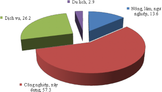
Figure 2.4. Chart of GDP proportion by economic sectors of Vinh Phuc in the period 2009 - 2013
Source: Document synthesis [ 10]
The industry and construction sector has developed strongly, especially industry plays a fundamental role, contributing to promoting socio-economic development, shifting the economic structure of the province, creating a new position for Vinh Phuc province's industry compared to the provinces in the Red River Delta and the whole country.
The value of the service sector has tended to increase rapidly in recent years, but the contribution of the service sector to the province's total GDP is still limited.
The socio-economic development goal by 2020 of Vinh Phuc is to become an industrial, service and tourism center of the region and the whole country. The average annual GDP growth rate in the period 2011 - 2020 is 14% - 15%/year. By 2020, the forecasted proportion of services is about 38% (of which tourism is 4%); agriculture - forestry - fishery 3% - 4%; industry and construction 58% - 60% [52].
2.2.2. Population and labor
The population of Vinh Phuc province in 2016 was 1,066,021 people. Density 863 people/km2 . The population size of the province is average, the population is relatively young, the labor force in working age accounts for a fairly high proportion, about 70% of the population.
Table 2.4. Population and labor force of Vinh Phuc province in the period 2010 - 2016
(Unit: person)
TT
Target | Year | |||||
2012 | 2013 | 2014 | 2015 | 2016 | ||
1 | Average population | 1,020,597 | 1,029,412 | 1,041,936 | 1,054,492 | 1,066,021 |
By gender: Male Female | 504,048 516,549 | 508,405 521,964 | 512,384 529,552 | 518,559 535,933 | 524,229 541,792 | |
Classified by urban and rural areas: Urban Rural | 238,300 782,297 | 240,841 788,571 | 242,921 799,015 | 245,848 808.644 | 248,536 817,485 | |
Year | 2010 | 2011 | 2014 | 2015 | 2016 | |
2 | Working age population | 606,848 | 608,372 | 621,189 | 631,383 | 629,770 |
By gender: Male Female | 298,721 308,119 | 299,475 308,897 | 300,863 320,326 | 300,686 330,697 | 310,248 319,522 | |
Classified by urban and rural areas: Urban Rural | 121,834 485,006 | 122,142 486,230 | 126,154 495,035 | 129,660 501,723 | 129,092 500,678 | |
Source: Vinh Phuc Provincial Statistics Office [ 10]
In recent years, the natural population growth rate of the province has been quite stable, in 2016 this rate was 11.4‰. In the period 2009 - 2016, Vinh Phuc province had an increasing urban population ratio.
rapidly, from 16.7% to 23.3%, the proportion of workers aged 15 and over in the economy who have received training increased from 14.5% (2010) to 24.1% (2016).
It is forecasted that the population of Vinh Phuc province will have many fluctuations in the coming period, by 2020 the population of the province will be about 1,230,000 people (an increase of 15.4% compared to 2016). The reason for the rapid population increase is due to the implementation of the goal of promoting industrial development, so there will be a mechanical labor force migrating from other provinces to Vinh Phuc [52].
2.2.3. Current status of infrastructure - technical facilities serving tourism
2.2.3.1. Infrastructure
(1) Transportation system
Vinh Phuc has a developed transportation network with 3 main types of transportation: road, railway and waterway. The transportation system is distributed quite reasonably, with high traffic density, ensuring economic exchange and tourism development between localities inside and outside the province.
+ Road traffic
The total length of roads through Vinh Phuc province is 4,058.4 km, with National Highways 2, 2B, 2C and 23 passing through. Of which, National Highway 2 is the external national highway with the provinces of the Northeast region of the North, running from Ha Giang, Tuyen Quang along the length of Vinh Phuc province to Hanoi. The South of National Highway 2 is connected to National Highway 18 connecting Noi Bai International Airport to Cai Lan deep-water port (Quang Ninh), which is very important for the transportation of goods and passengers of Vinh Phuc. The North of National Highway 2 through Thanh Thuy border gate (Ha Giang) to China is very convenient for promoting economic cooperation, cultural exchange and international tourism development. For the provinces of the Northwestern region, through Vinh Phuc province, there is the Noi Bai - Lao Cai expressway with a length of 245 km passing through 5 provinces and cities (Hanoi, Vinh Phuc, Phu Tho, Yen Bai, Lao Cai) and with China. The traffic axis opens up opportunities for socio-economic development, promoting tourism development in Vinh Phuc.
By 2030, Vinh Phuc aims to complete the construction of Ring Road 5; build a tunnel from National Highway 2B through Tam Dao to Thai Nguyen province (about 3 km long and a 5 km connecting road). The provincial road system continues to be upgraded and newly built.
some routes, including opening routes to serve tourism development in Vinh Phuc and neighboring areas; Building some new bridges such as: the bridge across the Red River connecting to National Highway 32, Duc Bac bridge across the Lo River to Phu Tho province [53].
+ Railway traffic
Currently, Vinh Phuc has the Hanoi - Lao Cai railway running through it, which is a great advantage for long-distance passenger and cargo transportation. The section running through Vinh Phuc is 35 km long with 5 stations including: Phuc Yen station (Phuc Yen), Huong Canh station (Binh Xuyen), Vinh Yen station (Vinh Yen), Huong Lai station and Bach Hac station (Vinh Tuong). This is a railway line connecting the capital Hanoi through Vinh Phuc to the midland and mountainous provinces in the North and with Yunnan (China). However, the efficiency of this route is not high due to the weak railway transport capacity, not creating conditions for socio-economic activities and tourism development on the entire route, including Vinh Phuc.
In the future, the railway system will be upgraded to meet national railway standards level I, speed 120 km/h; New construction of Lao Cai high-speed railway line
- Hanoi, 1,435 mm gauge, design speed 200 km/h, double track, using electric traction will be put into operation from 2015 - 2020 [53].
+ Water transport
The two main level II rivers managed by the central government are the Red River (30 km) and the Lo River (34 km). These two rivers are only navigable for vessels with a capacity of no more than 300 tons. The two local rivers are the Ca Lo River (27 km) and the Pho Day River (32 km), which are only navigable during the rainy season, serving vessels with a capacity of no more than 50 tons. Vinh Phuc currently has two ports: Vinh Thinh on the Red River and Nhu Thuy port on the Lo River.
(2) Power supply system
Vinh Phuc has a synchronously planned and invested power transmission and distribution system, ensuring sufficient supply for consumption, tourism, services and development of the province's industrial parks.
Currently, in the province, the transmission grid has 220 KV and 110 KV lines operating well. There are 3 110 KV transformer stations with a total capacity of 231 MVA, the central grid