Reflecting the modernization of the learning environment and changing students' attitudes and thinking about history: The appearance of Storymap has made the learning environment more modern. Because in the past, in order to convey knowledge at school, teachers had to use boards, chalk, paper and pens, maps, sand tables, images of relics and artifacts. However, thanks to StoryMap, these tools have been digitized. Teachers will no longer use boards to present knowledge but can also use the presentation creation part to present knowledge more vividly. In addition, maps and images will be digitized, no longer needing maps and images on paper. In other words, teachers only need a computer with an Internet connection to have all the tools to teach. Because of this convenience, schools are encouraged to add projectors, computers, speakers, and the Internet to their classrooms. Thanks to that, the learning environment for students and teachers has become more modern.
Thanks to the modernization of the learning environment, students' attitudes and thinking about history have changed. Thanks to the vividness of the maps and presentations on StoryMap, students feel more interested when they see them. At the same time, the effect makes it easier for learners to absorb knowledge, presenting knowledge more broadly, thereby students also feel excited and find historical knowledge more interesting.
For example: When we study and teach lesson 3 (period 1) Ancient Eastern countries (History textbook grade 10 - standard program), we will have to learn about Natural conditions such as: Location, terrain, river basins, land, climate, etc. in the textbook without maps and illustrations to determine the location of countries, locations of major rivers, etc. Thus, to help students have a perspective and approach to historical knowledge of this part, teachers can replace it by designing and using StoryMap as follows:
Maybe you are interested!
-

 Building a service delivery system via SMS based on mobile subscriber location - 1
 -
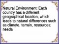 Natural Environment: Each country has a different geographical location, which leads to natural differences such as climate, terrain, resources; needs
 -
![Administrative Map of Bac Ninh Province and Map Showing the Location of Three Craft Villages (Dai Bai, Phu Lang, Phu Khe) [Source: Authors Collection]](https://tailieuthamkhao.com/uploads/2022/06/10/bien-doi-van-hoa-lang-nghe-truyen-thong-tren-dia-ban-tinh-bac-ninh-23-1-120x90.jpg) Administrative Map of Bac Ninh Province and Map Showing the Location of Three Craft Villages (Dai Bai, Phu Lang, Phu Khe) [Source: Author's Collection]
Administrative Map of Bac Ninh Province and Map Showing the Location of Three Craft Villages (Dai Bai, Phu Lang, Phu Khe) [Source: Author's Collection] -
 Location Map of Tourism Infrastructure
 -
 Solutions for tourism development in Tien Lang - 10
zt2i3t4l5ee
zt2a3gstourism, tourism development
zt2a3ge
zc2o3n4t5e6n7ts
- District People's Committees and authorities of communes with tourist attractions should support, promote, and provide necessary information to people, helping them improve their knowledge about tourism. Raise tourism awareness for local people.
*
* *
Due to limited knowledge and research time, the thesis inevitably has shortcomings. Therefore, I look forward to receiving guidance from teachers, experts as well as your comments to make the thesis more complete.
Chapter III Conclusion
Through the issues presented in Chapter II, we can come to some conclusions:
Based on the strengths of available tourism resources, the types of tourism in Tien Lang that need to be promoted in the coming time are sightseeing and resort tourism, discovery tourism, weekend tourism. To improve the quality and diversify tourism products, Tien Lang district needs to combine with local cultural tourism resources, at the same time combine with surrounding areas, build rich tourism products. The strengths of Tien Lang tourism are eco-tourism and cultural tourism, so developing Tien Lang tourism must always go hand in hand with restoring and preserving types of cultural tourism resources. Some necessary measures to support and improve the efficiency of exploiting tourism resources in Tien Lang are: strengthening the construction of technical facilities and labor force serving tourism, actively promoting and advertising tourism, and expanding forms of capital mobilization for tourism development.
CONCLUDE
I Conclusion
1. Based on the results achieved within the framework of the thesis's needs, some basic conclusions can be drawn as follows:
Tien Lang is a locality with great potential for tourism development. The relatively abundant cultural tourism resources and ecological tourism resources have great appeal to tourists. Based on this potential, Tien Lang can build a unique tourism industry that is competitive enough with other localities within Hai Phong city and neighboring areas.
In recent years, the exploitation of the advantages of resources to develop tourism and build tourist routes in Tien Lang has not been commensurate with the available potential. In terms of quantity, many resource objects have not been brought into the purpose of tourism development. In terms of time, the regular service time has not been extended to attract more visitors. Infrastructure and technical facilities are still weak. The labor force is still thin and weak in terms of expertise. Tourism programs and routes have not been organized properly, the exploitation content is still monotonous, so it has not attracted many visitors. Although resources have not been mobilized much for tourism development, they are facing the risk of destruction and degradation.
2. Based on the results of investigation, analysis, synthesis, evaluation and selective absorption of research results of related topics, the thesis has proposed a number of necessary solutions to improve the efficiency of exploiting tourism resources in Tien Lang such as: promoting the restoration and conservation of tourism resources, focusing on investment and key exploitation of ecotourism resources, strengthening the construction of infrastructure and tourism workforce. Expanding forms of capital mobilization. In addition, the thesis has built a number of tourist routes of Hai Phong in which Tien Lang tourism resources play an important role.
Exploiting Tien Lang tourism resources for tourism development is currently facing many difficulties. The above measures, if applied synchronously, will likely bring new prospects for the local tourism industry, contributing to making Tien Lang tourism an important economic sector in the district's economic structure.
REFERENCES
1. Nhuan Ha, Trinh Minh Hien, Tran Phuong, Hai Phong - Historical and cultural relics, Hai Phong Publishing House, 1993
2. Hai Phong City History Council, Hai Phong Gazetteer, Hai Phong Publishing House, 1990.
3. Hai Phong City History Council, History of Tien Lang District Party Committee, Hai Phong Publishing House, 1990.
4. Hai Phong City History Council, University of Social Sciences and Humanities, VNU, Hai Phong Place Names Encyclopedia, Hai Phong Publishing House. 2001.
5. Law on Cultural Heritage and documents guiding its implementation, National Political Publishing House, Hanoi, 2003.
6. Tran Duc Thanh, Lecture on Tourism Geography, Faculty of Tourism, University of Social Sciences and Humanities, VNU, 2006
7. Hai Phong Center for Social Sciences and Humanities, Some typical cultural heritages of Hai Phong, Hai Phong Publishing House, 2001
8. Nguyen Ngoc Thao (editor-in-chief, Tourism Geography, Hai Phong Publishing House, two volumes (2001-2002)
9. Nguyen Minh Tue and group of authors, Hai Phong Tourism Geography, Ho Chi Minh City Publishing House, 1997.
10. Nguyen Thanh Son, Hai Phong Tourism Territory Organization, Associate Doctoral Thesis in Geological Geography, Hanoi, 1996.
11. Decision No. 2033/QD – UB on detailed planning of Tien Lang town, Hai Phong city until 2020.
12. Department of Culture, Information, Hai Phong Museum, Hai Phong relics
- National ranked scenic spot, Hai Phong Publishing House, 2005. 13. Tien Lang District People's Committee, Economic Development Planning -
Culture - Society of Tien Lang district to 2010.
14.Website www.HaiPhong.gov.vn
APPENDIX 1
List of national ranked monuments
STT
Name of the monument
Number, year of decisiondetermine
Location
1
Gam Temple
938 VH/QĐ04/08/1992
Cam Khe Village- Toan Thang commune
2
Doc Hau Temple
9381 VH/QĐ04/08/1992
Doc Hau Village –Toan Thang commune
3
Cuu Doi Communal House
3207 VH/QĐDecember 30, 1991
Zone II of townTien Lang
4
Ha Dai Temple
938 VH/QĐ04/08/1992
Ha Dai Village –Tien Thanh commune
APPENDIX II
STT
Name of the monument
Number, year of decision
Location
1
Phu Ke Pagoda Temple
178/QD-UBJanuary 28, 2005
Zone 1 - townTien Lang
2
Trung Lang Temple
178/QD-UBJanuary 28, 2005
Zone 4 – townTien Lang
3
Bao Khanh Pagoda
1900/QD-UBAugust 24, 2006
Nam Tu Village -Kien Thiet commune
4
Bach Da Pagoda
1792/QD-UB11/11/2002
Hung Thang Commune
5
Ngoc Dong Temple
177/QD-UBNovember 27, 2005
Tien Thanh Commune
6
Tomb of Minister TSNhu Van Lan
2848/QD-UBSeptember 19, 2003
Nam Tu Village -Kien Thiet commune
7
Canh Son Stone Temple
2160/QD-UBSeptember 19, 2003
Van Doi Commune –Doan Lap
8
Meiji Temple
2259/QD-UBSeptember 19, 2002
Toan Thang Commune
9
Tien Doi Noi Temple
477/QD-UBSeptember 19, 2005
Doan Lap Commune
10
Tu Doi Temple
177/QD-UBJanuary 28, 2005
Doan Lap Commune
11
Duyen Lao Temple
177/QD-UBJanuary 28, 2005
Tien Minh Commune
12
Dinh Xuan Uc Pagoda
177/QD-UBJanuary 28, 2005
Bac Hung Commune
13
Chu Khe Pagoda
177/QD-UBJanuary 28, 2005
Hung Thang Commune
14
Dong Dinh
2848/QD-UBNovember 21, 2002
Vinh Quang Commune
15
President's Memorial HouseTon Duc Thang
177/QD-UBJanuary 28, 2005
NT Quy Cao
Ha Dai Temple
Ben Vua Temple
Tien Lang hot spring
div.maincontent .p { color: black; font-family:"Times New Roman", serif; font-style: normal; font-weight: normal; text-decoration: none; font-size: 14pt; margin:0pt; } div.maincontent p { color: black; font-family:"Times New Roman", serif; font-style: normal; font-weight: normal; text-decoration: none; font-size: 14pt; margin:0pt; } div.maincontent .s1 { color: black; font-family:"Times New Roman", serif; font-style: normal; font-weight: normal; font-size: 16pt; } div.maincontent .s2 { color: black; font-family:"Times New Roman", serif; font-style: italic; font-weight: bold; text-decoration: none; font-size: 14pt; } div.maincontent .s3 { color: black; font-family:"Times New Roman", serif; font-style: italic; font-weight: normal; text-decoration: none; font-size: 14pt; } div.maincontent .s4 { color: black; font-family:"Times New Roman", serif; font-style: normal; font-weight: normal; font-size: 14pt; } div.maincontent .s5 { color: black; font-family:"Times New Roman", serif; font-style: normal; font-weight: bold; font-size: 14pt; } div.maincontent .s6 { color: black; font-family:"Times New Roman", serif; font-style: normal; font-weight: normal; text-decoration: none; font-size: 14pt; } div.maincontent .s7 { color: black; font-family:"Times New Roman", serif; font-style: normal; font-weight: bold; text-decoration: none; font-size: 14pt; } div.maincontent .s8 { color: black; font-family:"Times New Roman", serif; font-style: normal; font-weight: normal; text-decoration: none; font-size: 9pt; vertical-align: 6pt; } div.maincontent .s9 { color: black; font-family:"Times New Roman", serif; font-style: normal; font-weight: bold; text-decoration: none; font-size: 12pt; } div.maincontent .s11 { color: black; font-family:"Times New Roman", serif; font-style: normal; font-weight: normal; tex
Solutions for tourism development in Tien Lang - 10
zt2i3t4l5ee
zt2a3gstourism, tourism development
zt2a3ge
zc2o3n4t5e6n7ts
- District People's Committees and authorities of communes with tourist attractions should support, promote, and provide necessary information to people, helping them improve their knowledge about tourism. Raise tourism awareness for local people.
*
* *
Due to limited knowledge and research time, the thesis inevitably has shortcomings. Therefore, I look forward to receiving guidance from teachers, experts as well as your comments to make the thesis more complete.
Chapter III Conclusion
Through the issues presented in Chapter II, we can come to some conclusions:
Based on the strengths of available tourism resources, the types of tourism in Tien Lang that need to be promoted in the coming time are sightseeing and resort tourism, discovery tourism, weekend tourism. To improve the quality and diversify tourism products, Tien Lang district needs to combine with local cultural tourism resources, at the same time combine with surrounding areas, build rich tourism products. The strengths of Tien Lang tourism are eco-tourism and cultural tourism, so developing Tien Lang tourism must always go hand in hand with restoring and preserving types of cultural tourism resources. Some necessary measures to support and improve the efficiency of exploiting tourism resources in Tien Lang are: strengthening the construction of technical facilities and labor force serving tourism, actively promoting and advertising tourism, and expanding forms of capital mobilization for tourism development.
CONCLUDE
I Conclusion
1. Based on the results achieved within the framework of the thesis's needs, some basic conclusions can be drawn as follows:
Tien Lang is a locality with great potential for tourism development. The relatively abundant cultural tourism resources and ecological tourism resources have great appeal to tourists. Based on this potential, Tien Lang can build a unique tourism industry that is competitive enough with other localities within Hai Phong city and neighboring areas.
In recent years, the exploitation of the advantages of resources to develop tourism and build tourist routes in Tien Lang has not been commensurate with the available potential. In terms of quantity, many resource objects have not been brought into the purpose of tourism development. In terms of time, the regular service time has not been extended to attract more visitors. Infrastructure and technical facilities are still weak. The labor force is still thin and weak in terms of expertise. Tourism programs and routes have not been organized properly, the exploitation content is still monotonous, so it has not attracted many visitors. Although resources have not been mobilized much for tourism development, they are facing the risk of destruction and degradation.
2. Based on the results of investigation, analysis, synthesis, evaluation and selective absorption of research results of related topics, the thesis has proposed a number of necessary solutions to improve the efficiency of exploiting tourism resources in Tien Lang such as: promoting the restoration and conservation of tourism resources, focusing on investment and key exploitation of ecotourism resources, strengthening the construction of infrastructure and tourism workforce. Expanding forms of capital mobilization. In addition, the thesis has built a number of tourist routes of Hai Phong in which Tien Lang tourism resources play an important role.
Exploiting Tien Lang tourism resources for tourism development is currently facing many difficulties. The above measures, if applied synchronously, will likely bring new prospects for the local tourism industry, contributing to making Tien Lang tourism an important economic sector in the district's economic structure.
REFERENCES
1. Nhuan Ha, Trinh Minh Hien, Tran Phuong, Hai Phong - Historical and cultural relics, Hai Phong Publishing House, 1993
2. Hai Phong City History Council, Hai Phong Gazetteer, Hai Phong Publishing House, 1990.
3. Hai Phong City History Council, History of Tien Lang District Party Committee, Hai Phong Publishing House, 1990.
4. Hai Phong City History Council, University of Social Sciences and Humanities, VNU, Hai Phong Place Names Encyclopedia, Hai Phong Publishing House. 2001.
5. Law on Cultural Heritage and documents guiding its implementation, National Political Publishing House, Hanoi, 2003.
6. Tran Duc Thanh, Lecture on Tourism Geography, Faculty of Tourism, University of Social Sciences and Humanities, VNU, 2006
7. Hai Phong Center for Social Sciences and Humanities, Some typical cultural heritages of Hai Phong, Hai Phong Publishing House, 2001
8. Nguyen Ngoc Thao (editor-in-chief, Tourism Geography, Hai Phong Publishing House, two volumes (2001-2002)
9. Nguyen Minh Tue and group of authors, Hai Phong Tourism Geography, Ho Chi Minh City Publishing House, 1997.
10. Nguyen Thanh Son, Hai Phong Tourism Territory Organization, Associate Doctoral Thesis in Geological Geography, Hanoi, 1996.
11. Decision No. 2033/QD – UB on detailed planning of Tien Lang town, Hai Phong city until 2020.
12. Department of Culture, Information, Hai Phong Museum, Hai Phong relics
- National ranked scenic spot, Hai Phong Publishing House, 2005. 13. Tien Lang District People's Committee, Economic Development Planning -
Culture - Society of Tien Lang district to 2010.
14.Website www.HaiPhong.gov.vn
APPENDIX 1
List of national ranked monuments
STT
Name of the monument
Number, year of decisiondetermine
Location
1
Gam Temple
938 VH/QĐ04/08/1992
Cam Khe Village- Toan Thang commune
2
Doc Hau Temple
9381 VH/QĐ04/08/1992
Doc Hau Village –Toan Thang commune
3
Cuu Doi Communal House
3207 VH/QĐDecember 30, 1991
Zone II of townTien Lang
4
Ha Dai Temple
938 VH/QĐ04/08/1992
Ha Dai Village –Tien Thanh commune
APPENDIX II
STT
Name of the monument
Number, year of decision
Location
1
Phu Ke Pagoda Temple
178/QD-UBJanuary 28, 2005
Zone 1 - townTien Lang
2
Trung Lang Temple
178/QD-UBJanuary 28, 2005
Zone 4 – townTien Lang
3
Bao Khanh Pagoda
1900/QD-UBAugust 24, 2006
Nam Tu Village -Kien Thiet commune
4
Bach Da Pagoda
1792/QD-UB11/11/2002
Hung Thang Commune
5
Ngoc Dong Temple
177/QD-UBNovember 27, 2005
Tien Thanh Commune
6
Tomb of Minister TSNhu Van Lan
2848/QD-UBSeptember 19, 2003
Nam Tu Village -Kien Thiet commune
7
Canh Son Stone Temple
2160/QD-UBSeptember 19, 2003
Van Doi Commune –Doan Lap
8
Meiji Temple
2259/QD-UBSeptember 19, 2002
Toan Thang Commune
9
Tien Doi Noi Temple
477/QD-UBSeptember 19, 2005
Doan Lap Commune
10
Tu Doi Temple
177/QD-UBJanuary 28, 2005
Doan Lap Commune
11
Duyen Lao Temple
177/QD-UBJanuary 28, 2005
Tien Minh Commune
12
Dinh Xuan Uc Pagoda
177/QD-UBJanuary 28, 2005
Bac Hung Commune
13
Chu Khe Pagoda
177/QD-UBJanuary 28, 2005
Hung Thang Commune
14
Dong Dinh
2848/QD-UBNovember 21, 2002
Vinh Quang Commune
15
President's Memorial HouseTon Duc Thang
177/QD-UBJanuary 28, 2005
NT Quy Cao
Ha Dai Temple
Ben Vua Temple
Tien Lang hot spring
div.maincontent .p { color: black; font-family:"Times New Roman", serif; font-style: normal; font-weight: normal; text-decoration: none; font-size: 14pt; margin:0pt; } div.maincontent p { color: black; font-family:"Times New Roman", serif; font-style: normal; font-weight: normal; text-decoration: none; font-size: 14pt; margin:0pt; } div.maincontent .s1 { color: black; font-family:"Times New Roman", serif; font-style: normal; font-weight: normal; font-size: 16pt; } div.maincontent .s2 { color: black; font-family:"Times New Roman", serif; font-style: italic; font-weight: bold; text-decoration: none; font-size: 14pt; } div.maincontent .s3 { color: black; font-family:"Times New Roman", serif; font-style: italic; font-weight: normal; text-decoration: none; font-size: 14pt; } div.maincontent .s4 { color: black; font-family:"Times New Roman", serif; font-style: normal; font-weight: normal; font-size: 14pt; } div.maincontent .s5 { color: black; font-family:"Times New Roman", serif; font-style: normal; font-weight: bold; font-size: 14pt; } div.maincontent .s6 { color: black; font-family:"Times New Roman", serif; font-style: normal; font-weight: normal; text-decoration: none; font-size: 14pt; } div.maincontent .s7 { color: black; font-family:"Times New Roman", serif; font-style: normal; font-weight: bold; text-decoration: none; font-size: 14pt; } div.maincontent .s8 { color: black; font-family:"Times New Roman", serif; font-style: normal; font-weight: normal; text-decoration: none; font-size: 9pt; vertical-align: 6pt; } div.maincontent .s9 { color: black; font-family:"Times New Roman", serif; font-style: normal; font-weight: bold; text-decoration: none; font-size: 12pt; } div.maincontent .s11 { color: black; font-family:"Times New Roman", serif; font-style: normal; font-weight: normal; tex
The StoryMap tool has an editor (open source) with many annotations with 8 different types of annotations and an annotation window that helps teachers add symbols to mark locations, area ranges, draw routes, arrows indicating locations, regions, areas, natural conditions, etc. appropriately. The foundation of world civilizations on the map (Figure 1.6). Furthermore, each annotation marked on the map has a window to add information related to that location, area, route, and direction of travel.
Figure 1.6a. Edit map, location marker annotation
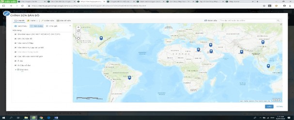
Figure 1.6b. Editing the map, adding notes and location markers
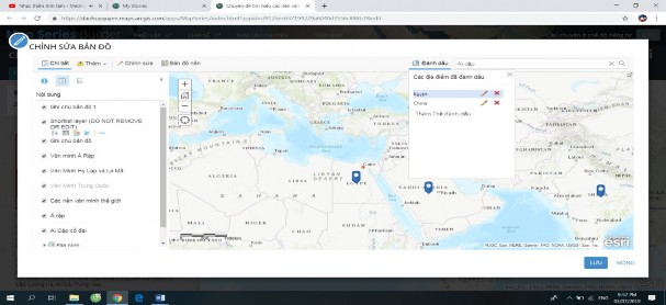
Figure 1.6c. Locating civilizations and major rivers
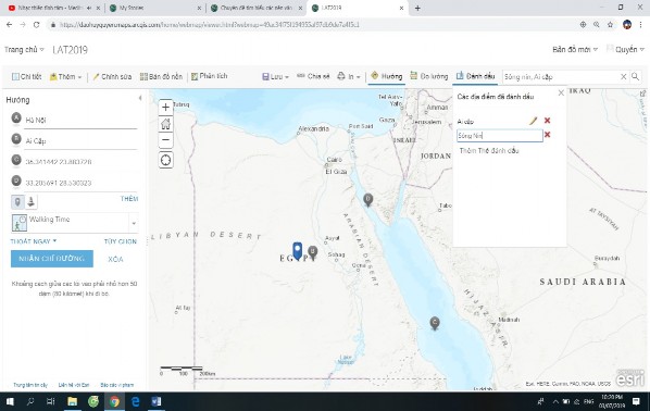
Figure 1.6d. View the attribute table on the map
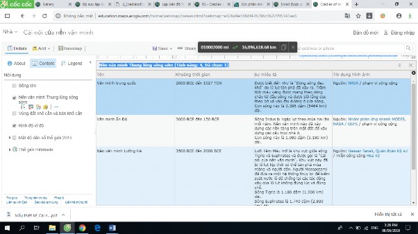
Thus, on the annotation section on StoryMap: Typically, when teachers want to show the locations of world civilizations and want to specifically show which world civilizations were formed based on the basins of major rivers. Instead of using many maps, teachers only need a single map on StoryMap, which can determine the entire location, terrain, ... of how world civilizations were formed. They can also see the system of major river basins on the map.
Creating such a map will be a powerful support tool for teachers in teaching and learning. Thanks to the ability to create vivid, detailed maps with a lot of lecture content, teachers can easily illustrate the content they are presenting in the lecture through the map. Along with the above advantages, illustrating the lesson content will be much more convenient because the liveliness of the map will help students have more interest, easier to absorb the lesson content, students can also easily imagine the context at that time from the past to the present and from the distant space to the nearer space through the geographical space that StoryMap has shown on the map.
About knowledge: StoryMap provides students with information about knowledge in the fastest and most accurate way from sources indicated on the map. Change the form of learning from passive (knowledge in textbooks) to active selection, exploration, acquisition of knowledge and memorization of knowledge information in their own way without depending on anyone. Through StoryMap, teachers provide students with information about events, phenomena, historical figures, images, documents, video clips, etc., helping students have a vivid overview of history. Using StoryMap helps students have a multi-dimensional view of history, especially accurately determining the geographical location, terrain, river basins, land, climate, of Eastern civilizations on the map of geographical space, which students previously only knew.
It is not possible to see the exact locations of these civilizations on a paper map.
At the same time, students will be really interested in participating in lessons in this way. They will gain knowledge and understanding of the history of Eastern civilizations through the landscape, rich content elements, impressive and attractive 3D interactive information through the lesson.
About skills: When using StoryMap, students can develop the ability to read and use online maps, which is an important skill in modern life, the ability to use information technology, exploit information, etc. In the case that students are assigned the task of designing a content or a problem or topic using the StoryMap tool, they will develop the ability to research, collect information, documents, use, present, report, and present learning products in an easy-to-understand, vivid and highly convincing way through the StoryMap tool.
Regarding attitude: High school students are at the age of adulthood, with the need to assert themselves, they will be very interested in designing and appreciating their own learning products. In the process of researching and collecting information, documents, video clips, etc., creating StoryMaps also creates conditions for students to access diverse and rich sources of information outside of textbooks. This has a great effect in helping students to objectively and multi-dimensionally evaluate the historical content they are learning, thereby forming a scientific worldview for students when studying and acquiring historical knowledge. At the same time, it enhances the spirit of patriotism and national pride for students, thereby students have attitudes and awareness in building and preserving traditional historical and cultural relics of Eastern peoples, including Vietnam.
Regarding capacity development orientation : In addition to developing practical skills of the subject, students also form and develop general capacities such as: self-study capacity, problem-solving capacity, cooperation capacity, communication capacity, capacity to use information technology, etc.
Regarding qualities: When acquiring knowledge through lessons using StoryMap, students will deeply remember the content of knowledge and develop the qualities of a global citizen in enhancing the spirit, attitude and awareness of building and preserving the traditional cultural and historical values of humanity and of ancient Eastern countries, including Vietnam.
1.2. Current status of designing and using StoryMap in teaching history in high schools
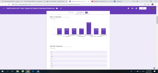
To have objective and scientific comments on the current status of designing and using StoryMap in teaching history in general, and teaching history of world civilizations in high schools in particular, we conducted a survey of 8 teachers of two high schools and 253 high school students and got the following results:
Chart 1.1. Results of the number of people participating in the online survey
1.2.1. Purpose of investigation and survey
- Investigate the design and use of StoryMap in history teaching to promote students' active participation in learning the subject.
- Thereby, it serves as a basis for comparison with scientific theory, finding the causes of the current situation and from there proposing principles and pedagogical measures to overcome existing problems.
- Subjects of investigation: History teachers at high schools in the Chuong My - Thanh Oai school cluster and students at Chuong My A High School.
- Investigation method: We directly went to high schools to learn, observe pedagogy, attend classes, interact with subject teachers and students, and at the same time investigate the current situation with objective multiple-choice questions through online survey forms, then analyze and process the data to have the basis to come to conclusions for the topic.
1.2.2. Investigation and survey content
- For teachers: Conduct a survey on their perceptions of designing and using StoryMaps in teaching history at high schools. The advantages and difficulties of teachers when designing and using StoryMaps in teaching history. (The survey form is in Appendix 1)
- For students: To investigate objectively and practically in the process of teaching History. We will conduct a survey on students' attitudes and interests in teachers' use of diagrams and StoryMaps in teaching History. Students' perceptions of the differences between two history lessons using StoryMap and not using StoryMap. The effectiveness of the lesson in regularly using StoryMap in teaching the subject. (The survey form is in Appendix 2)
1.2.3. Investigation and survey results
After the investigation and data processing using mathematical statistics and other methods, we draw the following conclusions:
1.2.3.1. Teaching aids.
- Currently, in high schools today, visual aids for teaching history are still lacking, especially diagrams. The history diagrams provided by the Ministry of Education and Training are still not enough.
- Teaching aids are limited in content and quantity. There are almost no history classrooms.
- Teaching materials are mainly written documents, while visual materials such as systems of diagrams, charts, graphs, chronologies, graphs, etc. are still static diagrams and charts, while teaching tools such as dynamic maps through teaching aids are not available or are still few and not rich in content.
1.2.3.2. On the teacher's side.
In current teaching, most teachers rarely or never use online teaching support tools. Based on that, through our survey, we found that most teachers are aware of the importance and significance of designing and using StoryMap tools in the history teaching process to promote students' positivity to improve the quality and effectiveness of history lessons.
However, many teachers still do not know about this StoryMap tool or sometimes hear colleagues talk about it but are "afraid" to use it or use it in a perfunctory manner because the preparation takes a lot of time, the content to be implemented in a lesson is too much, leading to the situation of "burning lesson plans". From there, we conducted a survey and investigation using a form to fill in the form via docs.google.com Online as follows: