Chapter 3
RESEARCH RESULTS
3.1. Some basic features of Binh Gia district - Lang Son province
3.1.1. Geographical location
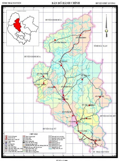
Figure 3.1: Administrative map of Binh Gia district
Phu Luong is a mountainous district located in the North of Thai Nguyen province.
Nguyen has National Highway 3 running through the district with a length of 38 km, located
in coordinates
Geography from
21036 to
21055 degrees
North latitude, 105037 to 105046 degrees
East Kinh; Northwest borders Dinh Hoa district, Southwest borders
Dai Tu district, south
Northeast borders Cho district
New Bac Kan province, south
East borders Dong Hy district, South borders Thai Nguyen city.
The whole district has an area of about 369.34 km2, with an average population of 107,230.
People
with 16 units
administrative
Commune/ward level includes 2 towns
town and 14 communes,
average population density 290 people/km2.
Table 3.1. Area, population, population density of Binh Gia district divided by commune, ward, and town in 2015
TT
Unit | Area Area (Km2) | Number of villages (hamlets, village, people's group) | Population Average (People) | Population density Number (People/Km2) | |
1 | TT Du | 0.213 | 6 | 4,007 | 18,821 |
2 | Giang Tien Town | 3,812 | 8 | 3,614 | 948 |
3 | Son Cam Commune | 16,824 | 19 | 12,276 | 730 |
4 | Co Lung Commune | 16,969 | 18 | 8,959 | 528 |
5 | Phan Me Commune | 25,310 | 26 | 10,626 | 420 |
6 | Vo Tranh Commune | 18,376 | 25 | 8,368 | 455 |
7 | Tuc Tranh Commune | 25,594 | 24 | 8,748 | 342 |
8 | Phu Do Commune | 22,201 | 25 | 5,419 | 244 |
9 | Yen Lac Commune | 42,976 | 23 | 6,948 | 162 |
10 | Dong Dat Commune | 39,887 | 23 | 10,301 | 258 |
11 | On Luong Commune | 17,696 | 10 | 3,229 | 182 |
12 | Phu Ly Commune | 15,485 | 12 | 2,956 | 191 |
13 | Hop Thanh Commune | 8,985 | 10 | 2,597 | 289 |
14 | Yen Do Commune | 35,611 | 17 | 6,598 | 185 |
15 | Yen Ninh Commune | 49,475 | 16 | 6,456 | 130 |
16 | Yen Trach Commune | 29,926 | 12 | 6.128 107,230 | 205 |
TOTAL | 369.34 | 274 | 290 | ||
Maybe you are interested!
-
 Improving the effectiveness of office administration at the Office of the People's Council and People's Committee of Loc Binh district, Lang Son province - 1
 -
 Improving the effectiveness of office administration at the Office of the People's Council and People's Committee of Loc Binh district, Lang Son province - 10
 -
 Solutions for tourism development in Tien Lang - 10
zt2i3t4l5ee
zt2a3gstourism, tourism development
zt2a3ge
zc2o3n4t5e6n7ts
- District People's Committees and authorities of communes with tourist attractions should support, promote, and provide necessary information to people, helping them improve their knowledge about tourism. Raise tourism awareness for local people.
*
* *
Due to limited knowledge and research time, the thesis inevitably has shortcomings. Therefore, I look forward to receiving guidance from teachers, experts as well as your comments to make the thesis more complete.
Chapter III Conclusion
Through the issues presented in Chapter II, we can come to some conclusions:
Based on the strengths of available tourism resources, the types of tourism in Tien Lang that need to be promoted in the coming time are sightseeing and resort tourism, discovery tourism, weekend tourism. To improve the quality and diversify tourism products, Tien Lang district needs to combine with local cultural tourism resources, at the same time combine with surrounding areas, build rich tourism products. The strengths of Tien Lang tourism are eco-tourism and cultural tourism, so developing Tien Lang tourism must always go hand in hand with restoring and preserving types of cultural tourism resources. Some necessary measures to support and improve the efficiency of exploiting tourism resources in Tien Lang are: strengthening the construction of technical facilities and labor force serving tourism, actively promoting and advertising tourism, and expanding forms of capital mobilization for tourism development.
CONCLUDE
I Conclusion
1. Based on the results achieved within the framework of the thesis's needs, some basic conclusions can be drawn as follows:
Tien Lang is a locality with great potential for tourism development. The relatively abundant cultural tourism resources and ecological tourism resources have great appeal to tourists. Based on this potential, Tien Lang can build a unique tourism industry that is competitive enough with other localities within Hai Phong city and neighboring areas.
In recent years, the exploitation of the advantages of resources to develop tourism and build tourist routes in Tien Lang has not been commensurate with the available potential. In terms of quantity, many resource objects have not been brought into the purpose of tourism development. In terms of time, the regular service time has not been extended to attract more visitors. Infrastructure and technical facilities are still weak. The labor force is still thin and weak in terms of expertise. Tourism programs and routes have not been organized properly, the exploitation content is still monotonous, so it has not attracted many visitors. Although resources have not been mobilized much for tourism development, they are facing the risk of destruction and degradation.
2. Based on the results of investigation, analysis, synthesis, evaluation and selective absorption of research results of related topics, the thesis has proposed a number of necessary solutions to improve the efficiency of exploiting tourism resources in Tien Lang such as: promoting the restoration and conservation of tourism resources, focusing on investment and key exploitation of ecotourism resources, strengthening the construction of infrastructure and tourism workforce. Expanding forms of capital mobilization. In addition, the thesis has built a number of tourist routes of Hai Phong in which Tien Lang tourism resources play an important role.
Exploiting Tien Lang tourism resources for tourism development is currently facing many difficulties. The above measures, if applied synchronously, will likely bring new prospects for the local tourism industry, contributing to making Tien Lang tourism an important economic sector in the district's economic structure.
REFERENCES
1. Nhuan Ha, Trinh Minh Hien, Tran Phuong, Hai Phong - Historical and cultural relics, Hai Phong Publishing House, 1993
2. Hai Phong City History Council, Hai Phong Gazetteer, Hai Phong Publishing House, 1990.
3. Hai Phong City History Council, History of Tien Lang District Party Committee, Hai Phong Publishing House, 1990.
4. Hai Phong City History Council, University of Social Sciences and Humanities, VNU, Hai Phong Place Names Encyclopedia, Hai Phong Publishing House. 2001.
5. Law on Cultural Heritage and documents guiding its implementation, National Political Publishing House, Hanoi, 2003.
6. Tran Duc Thanh, Lecture on Tourism Geography, Faculty of Tourism, University of Social Sciences and Humanities, VNU, 2006
7. Hai Phong Center for Social Sciences and Humanities, Some typical cultural heritages of Hai Phong, Hai Phong Publishing House, 2001
8. Nguyen Ngoc Thao (editor-in-chief, Tourism Geography, Hai Phong Publishing House, two volumes (2001-2002)
9. Nguyen Minh Tue and group of authors, Hai Phong Tourism Geography, Ho Chi Minh City Publishing House, 1997.
10. Nguyen Thanh Son, Hai Phong Tourism Territory Organization, Associate Doctoral Thesis in Geological Geography, Hanoi, 1996.
11. Decision No. 2033/QD – UB on detailed planning of Tien Lang town, Hai Phong city until 2020.
12. Department of Culture, Information, Hai Phong Museum, Hai Phong relics
- National ranked scenic spot, Hai Phong Publishing House, 2005. 13. Tien Lang District People's Committee, Economic Development Planning -
Culture - Society of Tien Lang district to 2010.
14.Website www.HaiPhong.gov.vn
APPENDIX 1
List of national ranked monuments
STT
Name of the monument
Number, year of decisiondetermine
Location
1
Gam Temple
938 VH/QĐ04/08/1992
Cam Khe Village- Toan Thang commune
2
Doc Hau Temple
9381 VH/QĐ04/08/1992
Doc Hau Village –Toan Thang commune
3
Cuu Doi Communal House
3207 VH/QĐDecember 30, 1991
Zone II of townTien Lang
4
Ha Dai Temple
938 VH/QĐ04/08/1992
Ha Dai Village –Tien Thanh commune
APPENDIX II
STT
Name of the monument
Number, year of decision
Location
1
Phu Ke Pagoda Temple
178/QD-UBJanuary 28, 2005
Zone 1 - townTien Lang
2
Trung Lang Temple
178/QD-UBJanuary 28, 2005
Zone 4 – townTien Lang
3
Bao Khanh Pagoda
1900/QD-UBAugust 24, 2006
Nam Tu Village -Kien Thiet commune
4
Bach Da Pagoda
1792/QD-UB11/11/2002
Hung Thang Commune
5
Ngoc Dong Temple
177/QD-UBNovember 27, 2005
Tien Thanh Commune
6
Tomb of Minister TSNhu Van Lan
2848/QD-UBSeptember 19, 2003
Nam Tu Village -Kien Thiet commune
7
Canh Son Stone Temple
2160/QD-UBSeptember 19, 2003
Van Doi Commune –Doan Lap
8
Meiji Temple
2259/QD-UBSeptember 19, 2002
Toan Thang Commune
9
Tien Doi Noi Temple
477/QD-UBSeptember 19, 2005
Doan Lap Commune
10
Tu Doi Temple
177/QD-UBJanuary 28, 2005
Doan Lap Commune
11
Duyen Lao Temple
177/QD-UBJanuary 28, 2005
Tien Minh Commune
12
Dinh Xuan Uc Pagoda
177/QD-UBJanuary 28, 2005
Bac Hung Commune
13
Chu Khe Pagoda
177/QD-UBJanuary 28, 2005
Hung Thang Commune
14
Dong Dinh
2848/QD-UBNovember 21, 2002
Vinh Quang Commune
15
President's Memorial HouseTon Duc Thang
177/QD-UBJanuary 28, 2005
NT Quy Cao
Ha Dai Temple
Ben Vua Temple
Tien Lang hot spring
div.maincontent .p { color: black; font-family:"Times New Roman", serif; font-style: normal; font-weight: normal; text-decoration: none; font-size: 14pt; margin:0pt; } div.maincontent p { color: black; font-family:"Times New Roman", serif; font-style: normal; font-weight: normal; text-decoration: none; font-size: 14pt; margin:0pt; } div.maincontent .s1 { color: black; font-family:"Times New Roman", serif; font-style: normal; font-weight: normal; font-size: 16pt; } div.maincontent .s2 { color: black; font-family:"Times New Roman", serif; font-style: italic; font-weight: bold; text-decoration: none; font-size: 14pt; } div.maincontent .s3 { color: black; font-family:"Times New Roman", serif; font-style: italic; font-weight: normal; text-decoration: none; font-size: 14pt; } div.maincontent .s4 { color: black; font-family:"Times New Roman", serif; font-style: normal; font-weight: normal; font-size: 14pt; } div.maincontent .s5 { color: black; font-family:"Times New Roman", serif; font-style: normal; font-weight: bold; font-size: 14pt; } div.maincontent .s6 { color: black; font-family:"Times New Roman", serif; font-style: normal; font-weight: normal; text-decoration: none; font-size: 14pt; } div.maincontent .s7 { color: black; font-family:"Times New Roman", serif; font-style: normal; font-weight: bold; text-decoration: none; font-size: 14pt; } div.maincontent .s8 { color: black; font-family:"Times New Roman", serif; font-style: normal; font-weight: normal; text-decoration: none; font-size: 9pt; vertical-align: 6pt; } div.maincontent .s9 { color: black; font-family:"Times New Roman", serif; font-style: normal; font-weight: bold; text-decoration: none; font-size: 12pt; } div.maincontent .s11 { color: black; font-family:"Times New Roman", serif; font-style: normal; font-weight: normal; tex
Solutions for tourism development in Tien Lang - 10
zt2i3t4l5ee
zt2a3gstourism, tourism development
zt2a3ge
zc2o3n4t5e6n7ts
- District People's Committees and authorities of communes with tourist attractions should support, promote, and provide necessary information to people, helping them improve their knowledge about tourism. Raise tourism awareness for local people.
*
* *
Due to limited knowledge and research time, the thesis inevitably has shortcomings. Therefore, I look forward to receiving guidance from teachers, experts as well as your comments to make the thesis more complete.
Chapter III Conclusion
Through the issues presented in Chapter II, we can come to some conclusions:
Based on the strengths of available tourism resources, the types of tourism in Tien Lang that need to be promoted in the coming time are sightseeing and resort tourism, discovery tourism, weekend tourism. To improve the quality and diversify tourism products, Tien Lang district needs to combine with local cultural tourism resources, at the same time combine with surrounding areas, build rich tourism products. The strengths of Tien Lang tourism are eco-tourism and cultural tourism, so developing Tien Lang tourism must always go hand in hand with restoring and preserving types of cultural tourism resources. Some necessary measures to support and improve the efficiency of exploiting tourism resources in Tien Lang are: strengthening the construction of technical facilities and labor force serving tourism, actively promoting and advertising tourism, and expanding forms of capital mobilization for tourism development.
CONCLUDE
I Conclusion
1. Based on the results achieved within the framework of the thesis's needs, some basic conclusions can be drawn as follows:
Tien Lang is a locality with great potential for tourism development. The relatively abundant cultural tourism resources and ecological tourism resources have great appeal to tourists. Based on this potential, Tien Lang can build a unique tourism industry that is competitive enough with other localities within Hai Phong city and neighboring areas.
In recent years, the exploitation of the advantages of resources to develop tourism and build tourist routes in Tien Lang has not been commensurate with the available potential. In terms of quantity, many resource objects have not been brought into the purpose of tourism development. In terms of time, the regular service time has not been extended to attract more visitors. Infrastructure and technical facilities are still weak. The labor force is still thin and weak in terms of expertise. Tourism programs and routes have not been organized properly, the exploitation content is still monotonous, so it has not attracted many visitors. Although resources have not been mobilized much for tourism development, they are facing the risk of destruction and degradation.
2. Based on the results of investigation, analysis, synthesis, evaluation and selective absorption of research results of related topics, the thesis has proposed a number of necessary solutions to improve the efficiency of exploiting tourism resources in Tien Lang such as: promoting the restoration and conservation of tourism resources, focusing on investment and key exploitation of ecotourism resources, strengthening the construction of infrastructure and tourism workforce. Expanding forms of capital mobilization. In addition, the thesis has built a number of tourist routes of Hai Phong in which Tien Lang tourism resources play an important role.
Exploiting Tien Lang tourism resources for tourism development is currently facing many difficulties. The above measures, if applied synchronously, will likely bring new prospects for the local tourism industry, contributing to making Tien Lang tourism an important economic sector in the district's economic structure.
REFERENCES
1. Nhuan Ha, Trinh Minh Hien, Tran Phuong, Hai Phong - Historical and cultural relics, Hai Phong Publishing House, 1993
2. Hai Phong City History Council, Hai Phong Gazetteer, Hai Phong Publishing House, 1990.
3. Hai Phong City History Council, History of Tien Lang District Party Committee, Hai Phong Publishing House, 1990.
4. Hai Phong City History Council, University of Social Sciences and Humanities, VNU, Hai Phong Place Names Encyclopedia, Hai Phong Publishing House. 2001.
5. Law on Cultural Heritage and documents guiding its implementation, National Political Publishing House, Hanoi, 2003.
6. Tran Duc Thanh, Lecture on Tourism Geography, Faculty of Tourism, University of Social Sciences and Humanities, VNU, 2006
7. Hai Phong Center for Social Sciences and Humanities, Some typical cultural heritages of Hai Phong, Hai Phong Publishing House, 2001
8. Nguyen Ngoc Thao (editor-in-chief, Tourism Geography, Hai Phong Publishing House, two volumes (2001-2002)
9. Nguyen Minh Tue and group of authors, Hai Phong Tourism Geography, Ho Chi Minh City Publishing House, 1997.
10. Nguyen Thanh Son, Hai Phong Tourism Territory Organization, Associate Doctoral Thesis in Geological Geography, Hanoi, 1996.
11. Decision No. 2033/QD – UB on detailed planning of Tien Lang town, Hai Phong city until 2020.
12. Department of Culture, Information, Hai Phong Museum, Hai Phong relics
- National ranked scenic spot, Hai Phong Publishing House, 2005. 13. Tien Lang District People's Committee, Economic Development Planning -
Culture - Society of Tien Lang district to 2010.
14.Website www.HaiPhong.gov.vn
APPENDIX 1
List of national ranked monuments
STT
Name of the monument
Number, year of decisiondetermine
Location
1
Gam Temple
938 VH/QĐ04/08/1992
Cam Khe Village- Toan Thang commune
2
Doc Hau Temple
9381 VH/QĐ04/08/1992
Doc Hau Village –Toan Thang commune
3
Cuu Doi Communal House
3207 VH/QĐDecember 30, 1991
Zone II of townTien Lang
4
Ha Dai Temple
938 VH/QĐ04/08/1992
Ha Dai Village –Tien Thanh commune
APPENDIX II
STT
Name of the monument
Number, year of decision
Location
1
Phu Ke Pagoda Temple
178/QD-UBJanuary 28, 2005
Zone 1 - townTien Lang
2
Trung Lang Temple
178/QD-UBJanuary 28, 2005
Zone 4 – townTien Lang
3
Bao Khanh Pagoda
1900/QD-UBAugust 24, 2006
Nam Tu Village -Kien Thiet commune
4
Bach Da Pagoda
1792/QD-UB11/11/2002
Hung Thang Commune
5
Ngoc Dong Temple
177/QD-UBNovember 27, 2005
Tien Thanh Commune
6
Tomb of Minister TSNhu Van Lan
2848/QD-UBSeptember 19, 2003
Nam Tu Village -Kien Thiet commune
7
Canh Son Stone Temple
2160/QD-UBSeptember 19, 2003
Van Doi Commune –Doan Lap
8
Meiji Temple
2259/QD-UBSeptember 19, 2002
Toan Thang Commune
9
Tien Doi Noi Temple
477/QD-UBSeptember 19, 2005
Doan Lap Commune
10
Tu Doi Temple
177/QD-UBJanuary 28, 2005
Doan Lap Commune
11
Duyen Lao Temple
177/QD-UBJanuary 28, 2005
Tien Minh Commune
12
Dinh Xuan Uc Pagoda
177/QD-UBJanuary 28, 2005
Bac Hung Commune
13
Chu Khe Pagoda
177/QD-UBJanuary 28, 2005
Hung Thang Commune
14
Dong Dinh
2848/QD-UBNovember 21, 2002
Vinh Quang Commune
15
President's Memorial HouseTon Duc Thang
177/QD-UBJanuary 28, 2005
NT Quy Cao
Ha Dai Temple
Ben Vua Temple
Tien Lang hot spring
div.maincontent .p { color: black; font-family:"Times New Roman", serif; font-style: normal; font-weight: normal; text-decoration: none; font-size: 14pt; margin:0pt; } div.maincontent p { color: black; font-family:"Times New Roman", serif; font-style: normal; font-weight: normal; text-decoration: none; font-size: 14pt; margin:0pt; } div.maincontent .s1 { color: black; font-family:"Times New Roman", serif; font-style: normal; font-weight: normal; font-size: 16pt; } div.maincontent .s2 { color: black; font-family:"Times New Roman", serif; font-style: italic; font-weight: bold; text-decoration: none; font-size: 14pt; } div.maincontent .s3 { color: black; font-family:"Times New Roman", serif; font-style: italic; font-weight: normal; text-decoration: none; font-size: 14pt; } div.maincontent .s4 { color: black; font-family:"Times New Roman", serif; font-style: normal; font-weight: normal; font-size: 14pt; } div.maincontent .s5 { color: black; font-family:"Times New Roman", serif; font-style: normal; font-weight: bold; font-size: 14pt; } div.maincontent .s6 { color: black; font-family:"Times New Roman", serif; font-style: normal; font-weight: normal; text-decoration: none; font-size: 14pt; } div.maincontent .s7 { color: black; font-family:"Times New Roman", serif; font-style: normal; font-weight: bold; text-decoration: none; font-size: 14pt; } div.maincontent .s8 { color: black; font-family:"Times New Roman", serif; font-style: normal; font-weight: normal; text-decoration: none; font-size: 9pt; vertical-align: 6pt; } div.maincontent .s9 { color: black; font-family:"Times New Roman", serif; font-style: normal; font-weight: bold; text-decoration: none; font-size: 12pt; } div.maincontent .s11 { color: black; font-family:"Times New Roman", serif; font-style: normal; font-weight: normal; tex -
 Current Status of Life Skills Education Methods for Students Through Experiential Activities at Secondary Schools in Gia Binh District, Bac Ninh Province
 -
 Internal control of corporate income tax compliance of small and medium enterprises at the Tax Department of Bu Gia Map district, Binh Phuoc province - 18
Source: Phu district statistical yearbook
Wage
3.1.2. Terrain
As a mountainous district of Thai Nguyen province, the terrain is relatively complex and steep. This is a difficulty for the district in developing infrastructure and transportation. It can be divided into 4 types of terrain as follows:
Rocky terrain in the West and Southwest
Steep rocky terrain from 250C to 300C accounts for 70% of the natural area.
Narrow valleys account for 3.5%
The gentle slopes with slopes from 150C to 200C have about 4000ha.
Phu Luong district is located in the transition zone between low mountains and inverted bowls, with an average slope of 200-500m above sea level. Gradually decreasing from Northwest to Southeast with an average slope of 15-20m, the terrain is relatively complex including plains, hills and rocky mountains, the system of rivers, streams, ponds and lakes is quite rich but mainly small in scale and unevenly distributed.
3.1.3. Climate
Phu Luong has diverse climate conditions with typical tropical monsoon climate of Vietnam. During the year, the climate is divided into 2
distinct seasons; hot and humid season from April to October, average temperature about
25-270C; dry and cold winter, the dry period lasts from October to April of the following year, the average temperature is from 10-180C, sometimes cold down to 4-50C. The amount of rainfall in the year is relatively large, mainly concentrated in the months of June, July, August, September. The average humidity in the rainy season is from 80-85%, and in the dry season it is about 12-15%.
3.1.4. Hydrology
Phu Luong has a small but rich network of rivers, streams, ponds and lakes running through 5 communes (Yen Do, Du town, Phan Me, Giang Tien town,
Co Lung) including 4 communes (Phu Do, Vo Tranh, Tuc Tranh, Son Cam) located
Cau River is the most important river originating from Bac Ninh province.
Kan is both the dividing line between Phu Luong and Dong Hy districts and the place that provides abundant water resources for the district.
With the above climate and hydrological conditions, it has greatly affected the production process and socio-economic development in the district. In the rainy season, with abundant water, hot and humid temperatures are favorable for agricultural production, especially rice, corn, potatoes, peanuts, tea and other fruit trees. In the dry season, there is not enough water for irrigation, partly due to the destruction of upstream forests, so the ability to generate water is poor.
3.1.5. Resources
Land resources: According to the results of the additional inspection and correction of the map
1/50,000 scale by FAO/UNECO quantitative method prescribed by the institute
agricultural planning and construction design. The whole district has 4 main soil groups: Alluvial soil, black soil, gray-fertile soil, red soil. The land area of the district is classified into 5 levels as follows:
From 0
From > 8
From >15
80 accounts for 7% of total land fund
150 accounts for 12% of total land fund
250 accounts for 11% of total land fund
From > 250 accounts for 50% of total land fund
Other soil types account for 20%.
Most of the district's land area has medium and thick soil layers.
thin therefore somewhat district.
impact on household economic development
farmers of
Table 3.2. Classification of soil thickness of the district in 2012
STT
Soil thickness | Rate (%) | Note | |
1 | Thick layer | 9.5 | |
2 | Medium thickness layer | 38.5 |
3
Thin layer | 52 |
Source: Phu Luong District Natural Resources and Environment Report 2015
2012
Water resources: The district has relatively abundant surface water resources, but the distribution is uneven. Floodwater resources are also relatively abundant, the water quality is generally good, ensuring the daily life and production of the people in the district.
Forest resources: Phu Luong is a highland district with a tropical climate, so the vegetation here is rich and diverse, with many precious woods. However, the reserves are still low, and there are currently programs to serve and develop forests sustainably. In 2012, the forest coverage rate was stable at 45%, forest management and protection were well implemented, promoting the effectiveness of the forest economy, paying special attention to afforestation and forest enrichment; in
Newly planted area was 896 hectares, reaching 119% of the plan; exploited wood output
estimated to reach 38,000 m3 = 233% of the plan; well implemented propaganda work on forest fire prevention, patrolling, controlling illegal forest exploitation, transportation of wood and animals in the area, discovered 41 administrative violations, confiscated 31.7 m3 of wood of all kinds.
Mineral resources: Although there are many types of minerals such as Tin,
Lead, Titanium, Coal have reserves
large amount like
But Phu Luong exploits
Insignificant mineral resources are still mainly in potential form.
In 2012, the district strengthened state management of finance.
resources and environment in the area; implement measures to prevent activities
mining and processing
illegal mineral processing, processing
strict with the
violations; general mineral exploitation and processing activities
on the area is basically stable. Environmental management is concerned.
Implement, focus on inspection, propaganda, and guidance for production and business establishments and people to implement measures to reduce environmental pollution, respond to "World Environment Day"; assess and confirm commitments
commitment to environmental protection for businesses and households engaged in production, business and livestock farming in the area. However, the environmental pollution situation at some mineral exploitation units and livestock farms still exists and needs to be rectified and thoroughly managed in the coming time.
About tradition: The people of Phu Luong ethnic groups are rich in love.
The country is a district with many ethnic groups living together, so there are many customs and practices of each ethnic group, but in general the district does not have customs or festivals.
What is outstanding besides the Duom Temple Festival?
held on the 6th day of the first lunar month every year
3.1.6. Land management and use situation
Land management in 2012 focused only on
work direction
land management and use, especially cases of violations of land law; implementing plans to speed up the process of granting, exchanging and re-issuing land use certificates.
certificate of ownership
land use system
map system
regular; complete
improve map
planning and planning report
land use at commune and district levels
district by 2020, plan
history
Land use 05 years 2011 2015; appraisal
Determine compensation plans for site clearance and land recovery, submit to the province for land allocation to investment units to construct works and projects to ensure timeliness and compliance with regulations.
Total number of applications for renewal, change and first registration
is 5,418 lakes
preliminary, 4,928 files resolved = 91%, 490 files remaining
in progress
During the process of examination and settlement; 6,935 land use right certificates were issued to households and individuals.
Table 3.3. Land and land use situation of the district in 2012
Unit: ha
Unit
Total land area by administrative boundaries main | Divide | ||||||
Agricultural Land | Forestry land | Hydroponics land product | Residential land | Special land | Unused land | ||
TT Du | 212.90 | 93.64 | 14.95 | 3.14 | 31.82 | 64.32 | 5.03 |
Giang Tien Town | 381.23 | 116.60 | 102.86 | 6.32 | 30.20 | 112.25 | 13.00 |
Son Cam Commune | 1,683.59 | 628.31 | 270.65 | 20.29 | 177.74 | 541.48 | 45.12 |
Co Lung Commune | 1,696.92 | 850.12 | 322.25 | 59.92 | 83.32 | 381.31 | 0.00 |
Phan Me Commune | 2,531.00 | 1,331.62 | 488.23 | 19.65 | 97.31 | 562.33 | 31.86 |
Vo Tranh Commune | 1,837.60 | 1,123.92 | 289.54 | 36.64 | 81.82 | 290.80 | 14.88 |
Tuc Tranh Commune | 2,559.35 | 1,342.07 | 885.81 | 43.52 | 74.38 | 209.87 | 3.70 |
Phu Do Commune | 2,258.81 | 740.28 | 967.34 | 41.31 | 260.42 | 149.51 | 99.95 |
Yen Lac Commune | 4,297.56 | 965.10 | 2,447.00 | 17.92 | 62.07 | 223.24 | 582.23 |
Dong Dat Commune | 3,988.71 | 1,454.21 | 1,837.92 | 86.66 | 84.88 | 478.39 | 46.65 |
On Luong Commune | 1,769.58 | 556.59 | 968.42 | 100.29 | 32.65 | 74.85 | 36.78 |
Phu Ly Commune | 1,548.50 | 438.89 | 913.46 | 61.75 | 29.57 | 88.88 | 15.95 |
Hop Thanh Commune | 898.54 | 345.69 | 435.82 | 20.82 | 27.29 | 60.60 | 8.32 |
Yen Do Commune | 3,561.14 | 782.74 | 2,377.73 | 108.40 | 61.20 | 180.00 | 51.07 |
Yen Ninh Commune | 4,718.61 | 944.48 | 3,250.96 | 68.36 | 77.39 | 281.35 | 96.11 |
Yen Trach Commune TOTAL | 2,990.03 36,934.33 | 619.37 12,333.63 | 1,746.53 17,319.47 | 140.06 835.05 | 274.96 1,487.02 | 158.16 3,857.34 | 51.05 1,101.70 |
By number
Source: Phu Luong District Statistical Yearbook 2012
District statistics 2012, total natural land area
The district's natural land area is 36,934.33 hectares, of which 08 communes and towns have a natural land area of less than 2,000 hectares and 08 units have an area of over 2,000 hectares. According to administrative boundaries, the largest area belongs to Yen Ninh commune with 4,718.61 hectares, accounting for 12.78%, the unit with the lowest land area is Du town with 212.90 hectares, accounting for 0.58% of the total area in the district.
Agricultural land Aquaculture land Forestry land Specialized land Residential land
Unused land
Structure (%)
10.4
4
2.9
33.4
2.3
46.9
Figure 3.2. Land use structure of Phu Luong district in 2012
Through a survey of land use in the district, it shows that
The total natural land area of the district is 36,934.33 ha and has been stable for a long time. The land structure is distributed as follows: Agricultural land 12,333.63 ha, accounting for 34.4%, of which annual crop land is 5,805.31 ha, perennial crop land is 6,528.34 ha. Aquaculture land 835.05 ha, accounting for 2.3%. Land
forestry
17,319.47 hectares, accounting for 46.9% of which is natural forest.
naturally occupied
4,066.32ha, planted forest 13,253.15ha. Specialized land 3,857.34ha
10.4%, residential land 1,487.02ha accounts for 4.0%, unused land 1,101.70ha accounts for 2.9%.
use
Table 3.4: Land and land use situation of the district in 2012
Target
Quantity (ha) | Structure (%) | |
Total natural land area | 36,934.33 | 100 |
I. Agricultural land | 12,333.63 | 33.4 |
1. Land for annual crops | 5,805.31 | 15.7 |