6
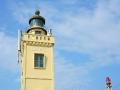
Stone Mountain | like Nhan Tower, from Bai Bang looking up it looks like a person sitting. At the top of the mountain, you can see Vung Ro - the relic of the ship without a number, Deo Ca, Bai Mon, Mui Dien Lighthouse, Han Dam, Van Phong Bay... - 706m above sea level, surrounded by evergreen broadleaf forest, the highlight on the top is the Bia Stone block, 76m high, this is the unique feature of this scenic spot. - It was ordered by King Minh Mang to be engraved on the Tuyen Dinh (in the Nine Urns in Thai Mieu) of Hue capital in 1840. Legend has it that King Le Thanh Tong had a stele engraved on this stone tower to determine the border between Dai Viet and Champa in 1471 [70]. - Here we can exploit tourism activities such as sightseeing, mountain climbing, adventure sports, and eco-tourism. | 5 | Very attractive | |
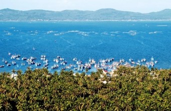
7 | Tu Nham Beach -Hoa Bay | - The beach is very beautiful, with soft white sand, long, wide, clean, clear, blue water. - The beach is surrounded by Vinh Hoa mountain (north) and Ong Dien cape (south). - Along the beach is a strip of deep green casuarina forest, hidden under the casuarina forest is a small fishing village, creating a beautiful, peaceful landscape. - This place is suitable for developing sightseeing tourism, beach tourism, sea sports and beach resorts. | 4 | Quite attractive |
8 | Xep Beach | - It is a small beach, the scenery is very beautiful, the sand is white, smooth, the beach is gentle, the water is clear, clean, the waves are calm. - To the north of the beach is Ganh Ong, made of shiny black basalt, columnar in shape, lying undulating in the waves, the cliffs are vertical and majestic, creating a wall to separate the sea from the grassy hills. The cliffs provide shade for the beach in the afternoon. On the top of Ganh Ong in spring, the grass is lush green. Adjacent to the south of Bai Xep is Ganh Ba, this is a low, gentle hill terrain, covered with green grass. - Bai Xep - Ganh Ong is the filming location of the movie "I see yellow flowers on green grass" . - Here you can exploit various types of tourism such as sightseeing, swimming, sea sports, eco-tourism. | 4 | Quite attractive |
9 | Mai Nha Island | - It is a small island, close to the shore, the natural landscape is still wild and beautiful. - The island is mostly covered with green carpets of casuarinas and forest trees. The eastern part of the terrain is low, with many large, smooth, flat rocks lying scattered among green lawns and wild flowers. The eastern and southern coasts are large rocks lying close to the water's edge, in many places the cliffs are vertical like house walls, at the foot of the cliffs are undulating rocks, floating in the clear sea water. - The island has two beaches: the front beach (small beach, east) and the back beach (long beach, west) with fine white sand, clear water, and shallow sea. Along the shore are many dry corals and shells of all shapes and colors. At sunset, the tide recedes, revealing the corals, half submerged, half exposed. - Here can exploit LHDL for sightseeing, ecology and sea sports. | 4 | Quite attractive |
10 | Beach | - Running along the East side of Doc Lap Street, about 10km long. The beach is gentle (slope 0.5-0.7%), coarse yellow sand, clean beach, fresh environment, adjacent to the beach is a strip of marine park with a system of trees and resorts. The beach is not obscured by architectural works that obscure the sea space. - To the west of Doc Lap Street are constructions, public agencies, administrative headquarters, streets, houses, and hotel systems. | 4 | Quite attractive |
Maybe you are interested!
-

 Identify Rating Levels and Rating Scales
zt2i3t4l5ee
zt2a3gstourism,quan lan,quang ninh,ecology,ecotourism,minh chau,van don,geography,geographical basis,tourism development,science
zt2a3ge
zc2o3n4t5e6n7ts
of the islanders. Therefore, this indicator will be divided into two sub-indicators:
a1. Natural tourism attractiveness a2. Cultural tourism attractiveness
b. Tourist capacity
The two island communes in Quan Lan have different capacities to receive tourists. Minh Chau Commune is home to many standard hotels and resorts, attracting high-income domestic and international tourists. Meanwhile, Quan Lan Commune has many motels mainly built and operated by local people, so the scale and quality are not high, and will be suitable for ordinary tourists such as students.
c. Time of exploitation of Quan Lan Island Commune:
Quan Lan tourism is seasonal due to weather and climate conditions and festivals only take place on certain days of the year, specifically in spring. In Quan Lan commune, the period from April to June and from September to November is considered the best time to visit Quan Lan because the cultural tourism activities are mainly associated with festivals taking place during this time.
Minh Chau island commune:
Tourism exploitation time is all year round, because this is a place with a number of tourist attractions with diverse ecosystems such as Bai Tu Long National Park Research Center, Tram forest, Turtle Laying Beach, so besides coming to the beach for tourism and vacation in the summer, Minh Chau will attract research groups to come for tourism combined with research at other times of the year.
d. Sustainability
The sustainability of ecotourism sites in Quan Lan and Minh Chau communes depends on the sensitivity of the ecosystems to climate changes.
landscape. In general, these tourist destinations have a fairly high level of sustainability, because they are natural ecosystems, planned and protected. However, if a large number of tourists gather at certain times, it can exceed the carrying capacity and affect the sustainability of the environment (polluted beaches, damaged trees, animals moving away from their habitats, etc.), then the sustainability of the above ecosystems (natural ecosystems, human ecosystems) will also be affected and become less sustainable.
e. Location and accessibility
Both island communes have ports to take tourists to visit from Van Don wharf:
- Quan Lan – Van Don traffic route:
Phuc Thinh – Viet Anh high-speed boat and Quang Minh high-speed boat, depart at 8am and 2pm from Van Don to Quan Lan, and at 7am and 1pm from Quan Lan to Van Don. There are also wooden boats departing at 7am and 1pm.
- Van Don - Minh Chau traffic route:
Chung Huong high-speed train, Minh Chau train, morning 7:30 and afternoon 13:30 from Van Don to Minh Chau, morning 6:30 and afternoon 13:00 from Minh Chau to Van Don.
f. Infrastructure
Despite receiving investment attention, the issue of infrastructure and technical facilities for tourism on Quan Lan Island is still an issue that needs to be resolved because it has a direct impact on the implementation of ecotourism activities. The minimum conditions for serving tourists such as accommodation, electricity, water, communication, especially medical services, and security work need to be given top priority. Ecotourism spots in Minh Chau commune are assessed to have better infrastructure and technical facilities for tourism because there are quite complete and synchronous conditions for serving tourists, meeting many needs of domestic and foreign tourists.
3.2.1.4. Determine assessment levels and assessment scales
Corresponding to the levels of each criterion, the index is the score of those levels in the order of 4, 3, 2, 1 decreasing according to the standard of each level: very attractive (4), attractive (3), average (2), less attractive (1).
3.2.1.5. Determining the coefficients of the criteria
For the assessment of DLST in the two communes of Quan Lan and Minh Chau islands, the students added evaluation coefficients to show the importance of the criteria and indicators as follows:
Coefficient 3 with criteria: Attractiveness, Exploitation time. These are the 2 most important criteria for attracting tourists to tourism in general and eco-tourism in particular, so they have the highest coefficient.
Coefficient 2 with criteria: Capacity, Infrastructure, Location and accessibility . Because the assessment area is an island commune of Van Don district, the above criteria are selected by the author with appropriate coefficients at the average level.
Coefficient 1 with criteria: Sustainability. Quan Lan has natural and human-made ecotourism sites, with high biodiversity and little impact from local human factors. Most of the ecotourism sites are still wild, so they are highly sustainable.
3.2.1.6. Results of DLST assessment on Quan Lan island
a. Assessment of the potential for natural tourism development
For Minh Chau commune:
+ Natural tourism attractiveness is determined to be very attractive (4 points) and the most important coefficient (coefficient 3), so the score of the Attractiveness criterion is 4 x 3 = 12.
+ Capacity is determined as average (2 points) and the coefficient is quite important (coefficient 2), then the score of Capacity criterion is 2 x 2 = 4.
+ Exploitation time is long (4 points), the most important coefficient (coefficient 3) so the score of the Exploitation time criterion is 4 x 3 = 12.
+ Sustainability is determined as sustainable (4 points), the important coefficient is the average coefficient (coefficient 1), so the score of the Sustainability criterion is 4 x 1 = 4 points
+ Location and accessibility are determined to be quite favorable (2 points), the coefficient is quite important (coefficient 2), the criterion score is 2 x 2 = 4 points.
+ Infrastructure is assessed as good (3 points), the coefficient is quite important (coefficient 2), then the score of the Infrastructure criterion is 3 x 2 = 6 points.
The total score for evaluating DLST in Minh Chau commune according to 6 evaluation criteria is determined as: 12 + 4 + 12 + 4 + 4 + 6 = 42 points
Similar assessment for Quan Lan commune, we have the following table:
Table 3.3: Assessment of the potential for natural ecotourism development in Quan Lan and Minh Chau communes
Attractiveness of self-tourismof course
Capacity
Mining time
Sustainability
Location and accessibility
Infrastructure
Result
Point
DarkMulti
Point
DarkMulti
Point
DarkMulti
Point
DarkMulti
Point
DarkMulti
Point
DarkMulti
CommuneMinh Chau
12
12
4
8
12
12
4
4
4
8
6
8
42/52
Quan CommuneLan
6
12
6
8
9
12
4
4
4
8
4
8
33/52
b. Assessment of the potential for humanistic tourism development
For Quan Lan commune:
+ The attractiveness of human tourism is determined to be very attractive (4 points) and the most important coefficient (coefficient 3), so the score of the Attractiveness criterion is 4 x 3 = 12.
+ Capacity is determined to be large (3 points) and the coefficient is quite important (coefficient 2), then the score of the Capacity criterion is 3 x 2 = 6.
+ Mining time is average (3 points), the most important coefficient (coefficient 3) so the score of the Mining time criterion is 3 x 3 = 9.
+ Sustainability is determined as sustainable (4 points), the important coefficient is the average coefficient (coefficient 1), so the score of the Sustainability criterion is 4 x 1 = 4 points.
+ Location and accessibility are determined to be quite favorable (2 points), the coefficient is quite important (coefficient 2), the criterion score is 2 x 2 = 4 points.
+ Infrastructure is rated as average (2 points), the coefficient is quite important (coefficient 2), then the score of the Infrastructure criterion is 2 x 2 = 4 points.
The total score for evaluating DLST in Quan Lan commune according to 6 evaluation criteria is determined as: 12 + 6 + 6 + 4 + 4 + 4 = 36 points.
Similar assessment with Minh Chau commune we have the following table:
Table 3.4: Assessment of the potential for developing humanistic eco-tourism in Quan Lan and Minh Chau communes
Attractiveness of human tourismliterature
Capacity
Mining time
Sustainability
Location and accessibility
Infrastructure
Result
Point
DarkMulti
Point
DarkMulti
Point
DarkMulti
Point
DarkMulti
Point
DarkMulti
Point
DarkMulti
Quan CommuneLan
12
12
6
8
9
12
4
4
4
8
4
8
39/52
Minh CommuneChau
6
12
4
8
12
12
4
4
4
8
6
8
36/52
Basically, both Minh Chau and Quan Lan localities have quite favorable conditions for developing ecotourism. However, Quan Lan commune has more advantages to develop ecotourism in a humanistic direction, because this is an area with many famous historical relics such as Quan Lan Communal House, Quan Lan Pagoda, Temple worshiping the hero Tran Khanh Du, ... along with local festivals held annually such as the wind praying ceremony (March 15), Quan Lan festival (June 10-19); due to its location near the port and long exploitation time, the beaches in Quan Lan commune (especially Quan Lan beach) are no longer hygienic and clean to ensure the needs of tourists coming to relax and swim; this is also an area with many beautiful landscapes such as Got Beo wind pass, Ong Phong head, Voi Voi cave, but the ability to access these places is still very limited (dirt hill road, lots of gravel and rocks), especially during rainy and windy times; In addition, other natural resources such as mangrove forests and sea worms have not been really exploited for tourism purposes and ecotourism development. On the contrary, Minh Chau commune has more advantages in developing ecotourism in the direction of natural tourism, this is an area with diverse ecosystems such as at Rua De Beach, Bai Tu Long National Park Conservation Center...; Minh Chau beach is highly appreciated for its natural beauty and cleanliness, ranked in the top ten most beautiful beaches in Vietnam; Minh Chau commune is also home to Tram forest with a large area and a purity of up to 90%, suitable for building bridges through the forest (a very effective type of natural ecotourism currently applied by many countries) for tourists to sightsee, as well as for the purpose of studying and researching.
Figure 3.1: Thenmala Forest Bridge (India) Source: https://www.thenmalaecotourism.com/(August 21, 2019)
3.2.2. Using SWOT matrix to evaluate Quan Lan island tourism
General assessment of current tourism activities of Quan Lan island is shown through the following SWOT matrix:
Table 3.5: SWOT matrix evaluating tourism activities on Quan Lan island
Internal agent
Strengths- There is a lot of potential for tourism development, especially natural ecotourism and humanistic ecotourism.- The unskilled labor force is relatively abundant.- resource environmentunpolluted, still
Weaknesses- Poorly developed infrastructure, especially traffic routes to tourist destinations on the island.- The team of professional staff is still weak.- Tourism products in general
quite wild, originalintact
general and DLST in particularalone is monotonous.
External agents
Opportunity- Tourism is a key industry in the socio-economic development strategy of the province and Van Don economic zone.- Quan Lan was selected as a pilot area for eco-tourism development within the framework of the green growth project between Quang Ninh province and the Japanese organization JICA.- The flow of tourists and especially ecotourism in the world tends toincreasing
Challenge- Weather and climate change abnormally.- Competition in tourism products is increasingly fierce, especially with other localities in the province such as Ha Long, Mong Cai...- Awareness of tourists, especially domestic tourists, about ecotourism and nature conservation is not high.
Through summary analysis using SWOT matrix we see that:
To exploit strengths and take advantage of opportunities, it is necessary to:
- Diversify products and service types (build more tourism routes aimed at specific needs of tourists: experiential tourism immersed in nature, spiritual cultural tourism...)
- Effective exploitation of resources and differentiated products (natural resources and human resources)
div.maincontent .p { color: black; font-family:"Times New Roman", serif; font-style: normal; font-weight: normal; text-decoration: none; font-size: 14pt; margin:0pt; } div.maincontent p { color: black; font-family:"Times New Roman", serif; font-style: normal; font-weight: normal; text-decoration: none; font-size: 14pt; margin:0pt; } div.maincontent .s1 { color: black; font-family:"Times New Roman", serif; font-style: normal; font-weight: normal; text-decoration: none; font-size: 13pt; } div.maincontent .s2 { color: black; font-family:"Times New Roman", serif; font-style: normal; font-weight: normal; text-decoration: none; font-size: 13pt; } div.maincontent .s3 { color: #0D0D0D; font-family:"Times New Roman", serif; font-style: normal; font-weight: bold; text-decoration: none; font-size: 14pt; } div.maincontent .s4 { color: black; font-family:"Times New Roman", serif; font-style: italic; font-weight: normal; text-decoration: none; font-size: 14pt; } div.maincontent .s5 { color: black; font-family:"Times New Roman", serif; font-style: italic; font-weight: bold; text-decoration: none; font-size: 14pt; } div.maincontent .s6 { color: black; font-family:"Times New Roman", serif; font-style: italic; font-weight: normal; text-decoration: none; font-size: 14pt; vertical-align: -3pt; } div.maincontent .s7 { color: black; font-family:"Times New Roman", serif; font-style: italic; font-weight: normal; text-decoration: none; font-size: 14pt; vertical-align: -2pt; } div.maincontent .s8 { color: black; font-family:"Times New Roman", serif; font-style: italic; font-weight: normal; text-decoration: none; font-size: 14pt; vertical-align: -1pt; } div.maincontent .s9 { color: black; font-family:"Times New Roman", serif; font-style: normal; font-weight: normal; text-decoration: none; font-size: 14pt; } div.maincontent .s10 { color: black; font-family:"Times New Roman", serif; font-style: normal; font-weight: bold; text-decoration: none; font-size: 14pt; } div.maincontent .s11 { color: black; font-family:"Times New Roman", serif; font-style: normal; font-weight: normal; text-decoration: none; font-size: 14pt; } div.maincontent .s12 { color: black; font-family:Symbol, serif; font-style: normal; font-weight: normal; text-decoration: none; font-size: 14pt; } div.maincontent .s13 { color: black; font-family:Wingdings; font-style: normal; font-weight: normal; text-decoration: none; font-size: 14pt; } div.maincontent .s14 { color: black; font-family:"Times New Roman", serif; font-style: normal; font-weight: normal; text-decoration: none; font-size: 9pt; vertical-align: 5pt; } div.maincontent .s15 { color: black; font-family:"Times New Roman", serif; font-style: normal; font-weight: normal; text-decoration: none; font-size: 9pt; vertical-align: 5pt; } div.maincontent .s16 { color: black; font-family:Cambria, serif; font-style: italic; font-weight: normal; text-decoration: none; font-size: 14pt; } div.maincontent .s17 { color: #080808; font-family:"Times New Roman", serif; font-style: normal; font-weight: bold; text-decoration: none; font-size: 14pt; } div.maincontent .s18 { color: #080808; font-family:"Times New Roman", serif; font-style: normal; font-weight: normal; text-decoration: none; font-size: 14pt; } div.maincontent .s19 { color: black; font-family:"Times New Roman", serif; font-style: normal; font-weight: normal; text-decoration: none; font-size: 11pt; } div.maincontent .s20 { color: black; font-family:"Times New Roman", serif; font-style: normal; font-weight: normal; text-decoration: none; font-size: 10pt; } div.maincontent .s21 { color: black; font-family:"Times New Roman", serif; font-style: normal; font-weight: bold; text-decoration: none; font-size: 11pt; } div.maincontent .s22 { color: black; font-family:"Times New Roman", serif; font-style: normal; font-weight: normal; text-decoration: none; font-size: 11pt; } div.maincontent .s23 { color: black; font-family:"Times New Roman", serif; font-style: italic; font-weight: normal; text-decoration: none; font-size: 14pt; } div.maincontent .s24 { color: #212121; font-family:"Times New Roman", serif; font-style: normal; font-weight: normal; tex
Identify Rating Levels and Rating Scales
zt2i3t4l5ee
zt2a3gstourism,quan lan,quang ninh,ecology,ecotourism,minh chau,van don,geography,geographical basis,tourism development,science
zt2a3ge
zc2o3n4t5e6n7ts
of the islanders. Therefore, this indicator will be divided into two sub-indicators:
a1. Natural tourism attractiveness a2. Cultural tourism attractiveness
b. Tourist capacity
The two island communes in Quan Lan have different capacities to receive tourists. Minh Chau Commune is home to many standard hotels and resorts, attracting high-income domestic and international tourists. Meanwhile, Quan Lan Commune has many motels mainly built and operated by local people, so the scale and quality are not high, and will be suitable for ordinary tourists such as students.
c. Time of exploitation of Quan Lan Island Commune:
Quan Lan tourism is seasonal due to weather and climate conditions and festivals only take place on certain days of the year, specifically in spring. In Quan Lan commune, the period from April to June and from September to November is considered the best time to visit Quan Lan because the cultural tourism activities are mainly associated with festivals taking place during this time.
Minh Chau island commune:
Tourism exploitation time is all year round, because this is a place with a number of tourist attractions with diverse ecosystems such as Bai Tu Long National Park Research Center, Tram forest, Turtle Laying Beach, so besides coming to the beach for tourism and vacation in the summer, Minh Chau will attract research groups to come for tourism combined with research at other times of the year.
d. Sustainability
The sustainability of ecotourism sites in Quan Lan and Minh Chau communes depends on the sensitivity of the ecosystems to climate changes.
landscape. In general, these tourist destinations have a fairly high level of sustainability, because they are natural ecosystems, planned and protected. However, if a large number of tourists gather at certain times, it can exceed the carrying capacity and affect the sustainability of the environment (polluted beaches, damaged trees, animals moving away from their habitats, etc.), then the sustainability of the above ecosystems (natural ecosystems, human ecosystems) will also be affected and become less sustainable.
e. Location and accessibility
Both island communes have ports to take tourists to visit from Van Don wharf:
- Quan Lan – Van Don traffic route:
Phuc Thinh – Viet Anh high-speed boat and Quang Minh high-speed boat, depart at 8am and 2pm from Van Don to Quan Lan, and at 7am and 1pm from Quan Lan to Van Don. There are also wooden boats departing at 7am and 1pm.
- Van Don - Minh Chau traffic route:
Chung Huong high-speed train, Minh Chau train, morning 7:30 and afternoon 13:30 from Van Don to Minh Chau, morning 6:30 and afternoon 13:00 from Minh Chau to Van Don.
f. Infrastructure
Despite receiving investment attention, the issue of infrastructure and technical facilities for tourism on Quan Lan Island is still an issue that needs to be resolved because it has a direct impact on the implementation of ecotourism activities. The minimum conditions for serving tourists such as accommodation, electricity, water, communication, especially medical services, and security work need to be given top priority. Ecotourism spots in Minh Chau commune are assessed to have better infrastructure and technical facilities for tourism because there are quite complete and synchronous conditions for serving tourists, meeting many needs of domestic and foreign tourists.
3.2.1.4. Determine assessment levels and assessment scales
Corresponding to the levels of each criterion, the index is the score of those levels in the order of 4, 3, 2, 1 decreasing according to the standard of each level: very attractive (4), attractive (3), average (2), less attractive (1).
3.2.1.5. Determining the coefficients of the criteria
For the assessment of DLST in the two communes of Quan Lan and Minh Chau islands, the students added evaluation coefficients to show the importance of the criteria and indicators as follows:
Coefficient 3 with criteria: Attractiveness, Exploitation time. These are the 2 most important criteria for attracting tourists to tourism in general and eco-tourism in particular, so they have the highest coefficient.
Coefficient 2 with criteria: Capacity, Infrastructure, Location and accessibility . Because the assessment area is an island commune of Van Don district, the above criteria are selected by the author with appropriate coefficients at the average level.
Coefficient 1 with criteria: Sustainability. Quan Lan has natural and human-made ecotourism sites, with high biodiversity and little impact from local human factors. Most of the ecotourism sites are still wild, so they are highly sustainable.
3.2.1.6. Results of DLST assessment on Quan Lan island
a. Assessment of the potential for natural tourism development
For Minh Chau commune:
+ Natural tourism attractiveness is determined to be very attractive (4 points) and the most important coefficient (coefficient 3), so the score of the Attractiveness criterion is 4 x 3 = 12.
+ Capacity is determined as average (2 points) and the coefficient is quite important (coefficient 2), then the score of Capacity criterion is 2 x 2 = 4.
+ Exploitation time is long (4 points), the most important coefficient (coefficient 3) so the score of the Exploitation time criterion is 4 x 3 = 12.
+ Sustainability is determined as sustainable (4 points), the important coefficient is the average coefficient (coefficient 1), so the score of the Sustainability criterion is 4 x 1 = 4 points
+ Location and accessibility are determined to be quite favorable (2 points), the coefficient is quite important (coefficient 2), the criterion score is 2 x 2 = 4 points.
+ Infrastructure is assessed as good (3 points), the coefficient is quite important (coefficient 2), then the score of the Infrastructure criterion is 3 x 2 = 6 points.
The total score for evaluating DLST in Minh Chau commune according to 6 evaluation criteria is determined as: 12 + 4 + 12 + 4 + 4 + 6 = 42 points
Similar assessment for Quan Lan commune, we have the following table:
Table 3.3: Assessment of the potential for natural ecotourism development in Quan Lan and Minh Chau communes
Attractiveness of self-tourismof course
Capacity
Mining time
Sustainability
Location and accessibility
Infrastructure
Result
Point
DarkMulti
Point
DarkMulti
Point
DarkMulti
Point
DarkMulti
Point
DarkMulti
Point
DarkMulti
CommuneMinh Chau
12
12
4
8
12
12
4
4
4
8
6
8
42/52
Quan CommuneLan
6
12
6
8
9
12
4
4
4
8
4
8
33/52
b. Assessment of the potential for humanistic tourism development
For Quan Lan commune:
+ The attractiveness of human tourism is determined to be very attractive (4 points) and the most important coefficient (coefficient 3), so the score of the Attractiveness criterion is 4 x 3 = 12.
+ Capacity is determined to be large (3 points) and the coefficient is quite important (coefficient 2), then the score of the Capacity criterion is 3 x 2 = 6.
+ Mining time is average (3 points), the most important coefficient (coefficient 3) so the score of the Mining time criterion is 3 x 3 = 9.
+ Sustainability is determined as sustainable (4 points), the important coefficient is the average coefficient (coefficient 1), so the score of the Sustainability criterion is 4 x 1 = 4 points.
+ Location and accessibility are determined to be quite favorable (2 points), the coefficient is quite important (coefficient 2), the criterion score is 2 x 2 = 4 points.
+ Infrastructure is rated as average (2 points), the coefficient is quite important (coefficient 2), then the score of the Infrastructure criterion is 2 x 2 = 4 points.
The total score for evaluating DLST in Quan Lan commune according to 6 evaluation criteria is determined as: 12 + 6 + 6 + 4 + 4 + 4 = 36 points.
Similar assessment with Minh Chau commune we have the following table:
Table 3.4: Assessment of the potential for developing humanistic eco-tourism in Quan Lan and Minh Chau communes
Attractiveness of human tourismliterature
Capacity
Mining time
Sustainability
Location and accessibility
Infrastructure
Result
Point
DarkMulti
Point
DarkMulti
Point
DarkMulti
Point
DarkMulti
Point
DarkMulti
Point
DarkMulti
Quan CommuneLan
12
12
6
8
9
12
4
4
4
8
4
8
39/52
Minh CommuneChau
6
12
4
8
12
12
4
4
4
8
6
8
36/52
Basically, both Minh Chau and Quan Lan localities have quite favorable conditions for developing ecotourism. However, Quan Lan commune has more advantages to develop ecotourism in a humanistic direction, because this is an area with many famous historical relics such as Quan Lan Communal House, Quan Lan Pagoda, Temple worshiping the hero Tran Khanh Du, ... along with local festivals held annually such as the wind praying ceremony (March 15), Quan Lan festival (June 10-19); due to its location near the port and long exploitation time, the beaches in Quan Lan commune (especially Quan Lan beach) are no longer hygienic and clean to ensure the needs of tourists coming to relax and swim; this is also an area with many beautiful landscapes such as Got Beo wind pass, Ong Phong head, Voi Voi cave, but the ability to access these places is still very limited (dirt hill road, lots of gravel and rocks), especially during rainy and windy times; In addition, other natural resources such as mangrove forests and sea worms have not been really exploited for tourism purposes and ecotourism development. On the contrary, Minh Chau commune has more advantages in developing ecotourism in the direction of natural tourism, this is an area with diverse ecosystems such as at Rua De Beach, Bai Tu Long National Park Conservation Center...; Minh Chau beach is highly appreciated for its natural beauty and cleanliness, ranked in the top ten most beautiful beaches in Vietnam; Minh Chau commune is also home to Tram forest with a large area and a purity of up to 90%, suitable for building bridges through the forest (a very effective type of natural ecotourism currently applied by many countries) for tourists to sightsee, as well as for the purpose of studying and researching.
Figure 3.1: Thenmala Forest Bridge (India) Source: https://www.thenmalaecotourism.com/(August 21, 2019)
3.2.2. Using SWOT matrix to evaluate Quan Lan island tourism
General assessment of current tourism activities of Quan Lan island is shown through the following SWOT matrix:
Table 3.5: SWOT matrix evaluating tourism activities on Quan Lan island
Internal agent
Strengths- There is a lot of potential for tourism development, especially natural ecotourism and humanistic ecotourism.- The unskilled labor force is relatively abundant.- resource environmentunpolluted, still
Weaknesses- Poorly developed infrastructure, especially traffic routes to tourist destinations on the island.- The team of professional staff is still weak.- Tourism products in general
quite wild, originalintact
general and DLST in particularalone is monotonous.
External agents
Opportunity- Tourism is a key industry in the socio-economic development strategy of the province and Van Don economic zone.- Quan Lan was selected as a pilot area for eco-tourism development within the framework of the green growth project between Quang Ninh province and the Japanese organization JICA.- The flow of tourists and especially ecotourism in the world tends toincreasing
Challenge- Weather and climate change abnormally.- Competition in tourism products is increasingly fierce, especially with other localities in the province such as Ha Long, Mong Cai...- Awareness of tourists, especially domestic tourists, about ecotourism and nature conservation is not high.
Through summary analysis using SWOT matrix we see that:
To exploit strengths and take advantage of opportunities, it is necessary to:
- Diversify products and service types (build more tourism routes aimed at specific needs of tourists: experiential tourism immersed in nature, spiritual cultural tourism...)
- Effective exploitation of resources and differentiated products (natural resources and human resources)
div.maincontent .p { color: black; font-family:"Times New Roman", serif; font-style: normal; font-weight: normal; text-decoration: none; font-size: 14pt; margin:0pt; } div.maincontent p { color: black; font-family:"Times New Roman", serif; font-style: normal; font-weight: normal; text-decoration: none; font-size: 14pt; margin:0pt; } div.maincontent .s1 { color: black; font-family:"Times New Roman", serif; font-style: normal; font-weight: normal; text-decoration: none; font-size: 13pt; } div.maincontent .s2 { color: black; font-family:"Times New Roman", serif; font-style: normal; font-weight: normal; text-decoration: none; font-size: 13pt; } div.maincontent .s3 { color: #0D0D0D; font-family:"Times New Roman", serif; font-style: normal; font-weight: bold; text-decoration: none; font-size: 14pt; } div.maincontent .s4 { color: black; font-family:"Times New Roman", serif; font-style: italic; font-weight: normal; text-decoration: none; font-size: 14pt; } div.maincontent .s5 { color: black; font-family:"Times New Roman", serif; font-style: italic; font-weight: bold; text-decoration: none; font-size: 14pt; } div.maincontent .s6 { color: black; font-family:"Times New Roman", serif; font-style: italic; font-weight: normal; text-decoration: none; font-size: 14pt; vertical-align: -3pt; } div.maincontent .s7 { color: black; font-family:"Times New Roman", serif; font-style: italic; font-weight: normal; text-decoration: none; font-size: 14pt; vertical-align: -2pt; } div.maincontent .s8 { color: black; font-family:"Times New Roman", serif; font-style: italic; font-weight: normal; text-decoration: none; font-size: 14pt; vertical-align: -1pt; } div.maincontent .s9 { color: black; font-family:"Times New Roman", serif; font-style: normal; font-weight: normal; text-decoration: none; font-size: 14pt; } div.maincontent .s10 { color: black; font-family:"Times New Roman", serif; font-style: normal; font-weight: bold; text-decoration: none; font-size: 14pt; } div.maincontent .s11 { color: black; font-family:"Times New Roman", serif; font-style: normal; font-weight: normal; text-decoration: none; font-size: 14pt; } div.maincontent .s12 { color: black; font-family:Symbol, serif; font-style: normal; font-weight: normal; text-decoration: none; font-size: 14pt; } div.maincontent .s13 { color: black; font-family:Wingdings; font-style: normal; font-weight: normal; text-decoration: none; font-size: 14pt; } div.maincontent .s14 { color: black; font-family:"Times New Roman", serif; font-style: normal; font-weight: normal; text-decoration: none; font-size: 9pt; vertical-align: 5pt; } div.maincontent .s15 { color: black; font-family:"Times New Roman", serif; font-style: normal; font-weight: normal; text-decoration: none; font-size: 9pt; vertical-align: 5pt; } div.maincontent .s16 { color: black; font-family:Cambria, serif; font-style: italic; font-weight: normal; text-decoration: none; font-size: 14pt; } div.maincontent .s17 { color: #080808; font-family:"Times New Roman", serif; font-style: normal; font-weight: bold; text-decoration: none; font-size: 14pt; } div.maincontent .s18 { color: #080808; font-family:"Times New Roman", serif; font-style: normal; font-weight: normal; text-decoration: none; font-size: 14pt; } div.maincontent .s19 { color: black; font-family:"Times New Roman", serif; font-style: normal; font-weight: normal; text-decoration: none; font-size: 11pt; } div.maincontent .s20 { color: black; font-family:"Times New Roman", serif; font-style: normal; font-weight: normal; text-decoration: none; font-size: 10pt; } div.maincontent .s21 { color: black; font-family:"Times New Roman", serif; font-style: normal; font-weight: bold; text-decoration: none; font-size: 11pt; } div.maincontent .s22 { color: black; font-family:"Times New Roman", serif; font-style: normal; font-weight: normal; text-decoration: none; font-size: 11pt; } div.maincontent .s23 { color: black; font-family:"Times New Roman", serif; font-style: italic; font-weight: normal; text-decoration: none; font-size: 14pt; } div.maincontent .s24 { color: #212121; font-family:"Times New Roman", serif; font-style: normal; font-weight: normal; tex -
 Factors Measuring International Tourists' Evaluation of Cultural Tourism Resources' Attractiveness Are Differently Influenced by Distance
 -
 Evaluation of human tourism resources of Ninh Binh province - 9
 -
 Evaluation of tourism resources and proposed orientation for ecotourism development on Co To Lon Island, Co To District, Quang Ninh Province - 13
 -
 Evaluation of the Current Situation of Human Resources Recruitment at Vietnam Truck Corporation
Tuy Hoa City | hotels, luxury resorts and tourist service facilities. - This place has good conditions to exploit many types of tourism such as beach resorts, sightseeing, swimming, beach sports, scuba diving. | |||
11 | Dong Cam Dam | - Is a historical - cultural relic and provincial scenic spot. - It is a magnificent irrigation project, one of the largest construction projects of the 20th century in Phu Yen province. The dam is 688m long, 22.5m above sea level. The dam body is built of granite, connected together by very even and strong cement joints, ensuring technical and aesthetic aspects. The dam body is long and straight like a giant ruler blocking the water flow, when the water overflows, it pours down to the lower steps, creating white foam, creating a beautiful, majestic landscape. The dam helps connect Tru Cac mountain and Qui Hau mountain, creating a charming landscape. - Halfway up Tru Cac mountain, there is a memorial stele recording the contributions of those who died while building the dam. The path up to the memorial stele has nearly 100 steps. - Here are favorable conditions for developing sightseeing and ecological tourism. | 4 | Quite attractive |
12 | Triem Duc mineral spring | - Naturally beautiful, there is a stream of hot water over 70 degrees Celsius flowing from the rock crevice and pouring into the lake (called the Lo abyss). Next to the abyss The furnace is a wide, flat sandy beach. On the left bank is a hundred-year-old Cây tree with a wide canopy and cool shade. The surrounding area is a peaceful landscape of hills covered with green forests. - Here we can exploit ecological tourism, medical treatment, and entertainment. | 3 | Medium |
13 | Van Hoa Plateau | - This is an area with beautiful landscape, the plateau's surface is relatively flat, surrounded by many hills and low mountains. On the plateau, there are many plants grown: acacia, pepper, cassava, sugarcane... creating a green plateau, especially during the harvest season. In the central area of the plateau, next to the traffic road (DT643) are Van Hoa Lake and Long Van Lake, the two lakes are 4km apart. The lake is relatively large, the lake surface is calm, the water is clear blue. Around the lake are green grass hills, sloping along the slope. - In Long Van lake area, there are tourist services such as: ecological amusement park, sunflower field, food service, homestay, coffee shop. - On Van Hoa plateau, there are relic sites such as Uncle Ho's church, Thi Thung go tunnel, horse racing track, and also the primeval forest belonging to the Spring Hall relic. - There is a red fruit tree (wild mulberry) in Son Long - Son Hoa; very unique and attractive to tourists. - This place is suitable for exploiting tourism activities such as resorts, ecology, and sightseeing. | 4 | Quite attractive |
14 | Song Ba Ha Hydroelectric Reservoir | - Song Ba Ha Hydroelectric Lake cuts across the flow of Ba River, the lake surface area is large, the shape of the lake meanders along the flow of the river, surrounded by deep green mountains and forests. The lake water changes with the seasons, in the dry season people often row boats to fish on the lake, along the lake there are small fishermen's camps. - The lake's dam is majestic, 45.5 meters high, 1357 meters long, including 12 flood gates. The dam area is an attractive place for visitors to visit and take photos. - Here can develop sightseeing and ecological tourism. | 3 | Medium |
15
Song Hinh Hydroelectric Reservoir | - Beautiful scenery. In the rainy season, the lake is full of water, as large as a sea lake, with a few small islands covered with lush green forests emerging in the middle of the lake. In the dry season, the lake dries up, revealing many alluvial flats, the water meanders along the alluvial flats and islands, creating many strange and beautiful shapes. The scenery here is most beautiful around 5-6 pm when the sun is about to set behind the mountains. - Surrounding the lake are majestic mountains and forests. When the weather is nice, you can also see Chu Mu mountain peak (about 2051m high) and Vong Phu mountain (mother and child) on the Vong Phu - Deo Ca range. The lake has a lot of fish, fishing in the lake is a hobby of many tourists. - The dam of the lake is a unique architectural work of Phu Yen. Currently, the spillway area is an attractive place for visitors to visit and take photos. - Song Hinh hydroelectric lake is favorable for developing sightseeing and ecological tourism. | 4 | Quite attractive | |
16 | Ho Xuan Huong | - Located right in the center of Hai Rieng town, beautiful and romantic. The lake is large, horizontally Y-shaped with its base facing East. The water surface is calm, clear, and curvy. Around the lake are grass and green trees, especially the pine forest near the lake, creating a cool space for the lake. Next to the lake is a traffic road (Nguyen Van Troi, Ho Xuan Huong and Hai Ba Trung). Across the lake is a concrete bridge leading to Le Diem cultural village (here there are brocade weaving, handicraft weaving, traditional wine making and festivals of ethnic minorities). - The lake is also where the boat racing festival takes place at the beginning of the year (the 6th day of Tet). - The types of tourism suitable for this place are natural eco-tourism, resort and cultural tourism with the characteristics of ethnic minorities. | 4 | Quite attractive |
17 | H'Ly Waterfall | - The waterfall is most beautiful in the rainy season (also known as Tay Du Ky waterfall). The waterfall consists of a large, flat granite block with a vertical wall cutting across the stream, like a spillway. In the dry season, there is very little water. In the rainy season, water from the spillway pours down, creating white foam, creating a majestic scene. At the foot of the waterfall are large, massive, close-together original rocks. The waterfall is about 20m high and about 30m wide. Water from the waterfall flows down a small stream and then flows into the Song Hinh hydroelectric lake. Surrounding the waterfall is a lush, tall, shady old forest. - The technical infrastructure is built with beautiful architecture, the wooden stilt houses are very majestic, the campus is large, there is a parking lot, and there is food service. - This is a suitable location to exploit tourism activities such as entertainment, ecology, and sightseeing. | 4 | Quite attractive |
3.1.2.2. Evaluation of the uniqueness/uniqueness of the resource criteria
Table 3.3: Summary of evaluation results of the criteria for the level of uniqueness/uniqueness of resources
TT
TNTN Point Name | Target achieved | Rating Points | Rating level |
1
Vinh Xuan Dai Bay | - It is a large bay with an area of 13,500 hectares, one of 45 national tourist areas (planned to 2030). - Xuan Dai Bay's landscape is very diverse, with many small coves, beautiful beaches, rocky reefs, rocky islands... (Ong Da Cape, Den Cape, Do Cape, Ba Cape, Lam Cape, Dong Cape, Su Cape, Chao Cape, Me Cape, La Cape, Dong Tranh Cape, Tuong Cape, Mom Islet, Ho Yen Islet, Tai Ma Cape,...). - Is the largest concentrated lobster farming area in Vietnam.
Figure 3. 4: Coconut forest along Xuan Dai Bay Figure 3. 5: Vung Lam (photo: Nguyen Huu Xuan) (photo: Duong Thanh Xuan) | 4 | Quite unique | |
2 | Ganh Da Dia | - Ganh Da Dia is unique in its geological and geomorphological value and is the most unique columnar basalt geological heritage on the coast of our country. - A unique and rare geological wonder in the world, of great significance, representing the country: In the world, coastal columnar basalt cliffs are only found in 4 other places ( Giant's Causeway in Northeast Ireland; Fingal's cliffs on Staffa Island, Scotland; Los O'rganos cliffs in the Canary Islands, Spain and Jusangjeolli cliffs on Jeju Island, South Korea. | 5 | Very unique |
3 | Hon Yen Complex | - Is a tourist destination associated with a shallow coral ecosystem (exposed at lowest tide). - Is a columnar basalt island; Next to it is Hon Sun - the only volcanic tuft island in our country. - There is a road connecting the island (to the foot of Hon Yen) when the tide recedes. | 4 | Rather unique |
4 | O Loan Lagoon | - Is a coastal water body created by sand dikes blocking the sea - Belongs to the type of coastal lagoon that is only formed in the central coastal region of our country. - Is a place with rich ecosystem, especially precious seafood species, famous throughout the country | 4 | Quite toxic unique |
5
Mon Beach - Dai Lanh Cape | - Is the place to welcome the first sunrise on the mainland of Vietnam. It is the base point A8 (the 8th point out of 11 points to determine the baseline of Vietnam). - Dai Lanh Cape belongs to the national heritage of coastal erosion [10]. | 4 | Rather unique | |
6 | Stone Mountain | The unique feature of this scenic spot is the 76m high intrusive igneous rock block, which has been exposed under the impact of the weathering process on the top of Da Bia mountain (706m high); this is the largest mass of granite intrusive complex in Phu Yen territory and is a unique terrain form of our country. - Belonging to the heritage, geological and geomorphological wonder of the coastal massif ranked nationally [10]. | 4 | Quite unique |
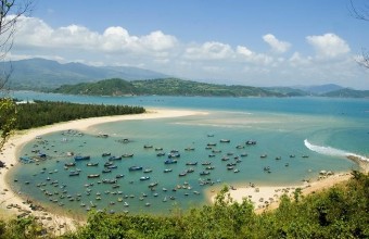
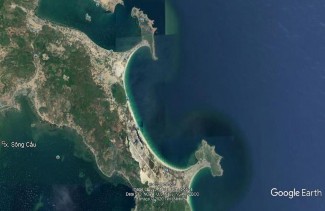
7 | Tu Nham Beach -Hoa Bay | The uniqueness here is the presence of two symmetrical Tom-bo-lo (sandbanks connecting the islands) forming a balanced C shape - extremely unique and beautiful. According to the assessment of leading Vietnamese geomorphologists, the presence of symmetrical sandbanks connecting the islands like in Xuan Dai Bay area is always considered a masterpiece of nature, a rare type in the world (Figure 3.6). Figure 3.6: Two symmetrical lobsters at Tu Nham beach - Vinh Hoa (photo: google Earth) | 5 | Very unique |
8 | Xep Beach | It is a small beach, 500m long, with golden sand and very beautiful. Bai Xep is located between Ganh Ong - Ganh Ba - a highlight of the Land of Yellow Flowers - Green Grass of Phu Yen. | 3 | Medium |
9 | Mai Nha Island | No unique features. | 2 | Least unique |
10 | Tuy Hoa City Beach Peace | No unique features. | 2 | Less toxic unique |
11 | Dong Cam Dam | The dam was built in 1917, taking advantage of natural advantages (terrain gradation) to build an irrigation system with two water channels, the North and South canals, irrigating the entire Tuy Hoa rice area of 22,000 hectares. | 3 | Medium |
12 | Triem Duc mineral spring | The unique feature here is that there is a hot water source flowing from the granite cliff on the left bank of Ky Lo River, pouring into the water basin next to it (Lo basin) and then merging into Ky Lo River. The hot mineral water is about 70 degrees Celsius and can be boiled. some types of eggs, clear water, has a characteristic mineral smell. According to analysis of Pasteur Institute Nha Trang, Triem Duc mineral water belongs to the group of silicon-fluorine mineral water, very hot, physical properties: clear, odorless, bland taste; type | 3 | Medium |
Chemical: sodium bicarbonate water, very low mineralization. Mud and water in the stream can cure some heart diseases. veins, joints, skin diseases...[37]. In Phu Yen, there are 4 hot mineral water points, but only 2 points have water temperatures above 70 degrees Celsius, which can boil eggs: Triem Duc and Phu Sen. | ||||
13 | High Nguyen Van Hoa | A product of the Dai Nga basalt eruption, it is the only basalt plateau 300-400m high in the Central Coast region of Vietnam. The landscape is diverse, the climate is quite mild and cool. | 3 | Medium |
14 | Lake Song Ba Ha power plant | No unique features. | 2 | Least unique |
15 | Lake Song Hinh electricity | No unique features. | 2 | Least unique |
16 | Ho Xuan Huong | No unique features. | 2 | Less toxic unique |
17 | H'Ly Waterfall | No unique features. | 2 | Least unique |
3.1.2.3. Evaluation of tourism capacity criteria of resource points
a. Some standards for evaluating tourist capacity (according to TCVN 7801: 2008; [71]; [72]; [73]).
* For sightseeing tours: Area for visitors: 4m2 / person;
Average number of visitors per group: 15 people; Sailboats: 2-4 boats/ha; Outdoor recreation: 100m2 / person; Picnic: 40-100 people/ha; Minimum distance to ensure safety between two boats: 200m
* For mountain climbing sports tourism: Distance between two tourists when climbing: 1m; Minimum distance between climbing groups: 50m.
* For sea tourism and sea sports: The sandy beach area for tourists is 10m2 / person; Maximum capacity for sea bathing is 5m of coastline/person; Average time for each diving session: 30 minutes; Area for tourists diving: 20m2 / person; Area for tourists diving with equipment: 50m2 / person; Beach length for tourists to relax: 10m/person.
* For resort tourism: Area for infrastructure construction and ensuring environmental quality: 50 m2 / person; Outdoor entertainment: 100m2 / person; Resort density: 60 - 100 beds/ha
b. Assessment of tourism carrying capacity for resource sites
Tourism capacity is assessed in detail for tourist destinations that are representative of the most typical type of tourism. Other destinations with similar characteristics will be applied similarly. The thesis only provides the assessment results.
- With LHDL, sightseeing, and experiencing on the water can be exploited well at the following locations: Xuan Dai Bay, O Loan lagoon, Song Hinh hydroelectric lake, Ba Ha river hydroelectric lake, Xuan Huong lake. Xuan Dai Bay is chosen for detailed assessment.
- With LHDL for sightseeing, picnicking, and sightseeing on land, it can be well exploited at the following locations: Ganh Da Dia, Dong Cam dam, H'Ly waterfall, Triem Duc mineral spring. Ganh Da Dia was chosen for detailed assessment.
- With LHDL, swimming and playing on the beach can be exploited well at the following locations: Tu Nham Beach - Hoa Bay, Xep Beach, Tuy Hoa Beach, Mon Beach, Song Cau Beach (along Xuan Dai Bay). Tuy Hoa Beach is chosen for detailed assessment.
- With LHDL, mountain climbing and sightseeing can be exploited well at the locations: Da Bia Mountain, Dai Lanh Cape. Da Bia Mountain is chosen for detailed evaluation.
- With LHDL, island tours can be well exploited at the following locations: Hon Yen, Cu Lao Mai Nha. Hon Yen is chosen for detailed evaluation.
- In Van Hoa plateau, the area selected for evaluation for DLND is around Long Van lake, other tourist spots are evaluated for sightseeing tourism.
(Climate data used to calculate the carrying capacity for the TNTN sites see Appendix 2, detailed assessment of carrying capacity see Appendix 8).
Table 3.4: Results of tourism capacity assessment of resource points
TT
Tourist spot/area | PCC (people/day) | RCC (people/day) | ECC (people/day) | Rating Points | Rating level | |
1 | Bay of Spring: - Water surface - Song Cau Beach | 9,440 7,190 2,250 | 5,800 4.103 1,697 | 1,437 250 1,187 | 5 | Very large |
2 | Ganh Da Dia | 9,305 | 5,078 | 2,539 | 5 | Very large |
3 | Hon Yen: - On land - Water surface | 16,750 8,750 8,000 | 5,867 827 5,040 | 918 414 504 | 4 | Sizable |
4 | O Loan Lagoon | 5,148 | 1,812 | 382 | 2 | Small |
5 | Bai Mon - Mui Dai Lanh - Mon Beach - Mui Dai sightseeing route Cold | 9,866 8,666 1,200 | 3,472 3050 422 | 882 619 263 | 4 | Sizable |
6 | Stone Mountain | 948 | 584 | 584 | 3 | TB |
7 | Tu Nham Beach - Bay Peace | 12,000 | 8,449 | 3,450 | 5 | Very large |
8 | Xep Beach - Beach - Grassy hill | 24,000 12,000 12,000 | 12,000 6,000 6,000 | 3,618 1 , 890 18.90 | 5 | Very large |
9 | Cu Lao Mai Home | 3,690 | 1,393 | 425 | 3 | TB |
10 | City Beach Tuy Hoa | 10,000 | 7,290 | 3,645 | 5 | Very large |
11 | Dong Cam Dam | 528 | 246 | 257 | 2 | Small |
12 | Mineral spring Triem Duc | 375 | 170 | 90 | 1 | Very small |
13 | Van Hoa Plateau: - Ho Long Van - A&P Farm - Go Thi Thung tunnel - Uncle Ho's Church | 4,095 1,600 850520 1.125 | 2,334 912 485 296 641 | 1,897 729 388 267 513 | 5 | Very large |
14 | Hydroelectric lake Ba Ha River | 2,397 | 1,392 | 709 | 4 | Sizable |
15 | Hydroelectric lake | 12,357 | 5,719 | 1715 | 5 | Very large |