+ Fe content: Reached a high value in 2011 (12.7 mg/l - exceeding QCVN 08:2008/BTNMT 8.5 times), is gradually decreasing, fluctuating gradually stably, reaching 0.21 mg/l in 2015;
+ NH 4 + content : Monitoring results from 2011 - 2015, NH 4 + content is always at high level, close to or exceeding the allowable standard many times. There is a tendency to decrease gradually over the years, reaching a peak in 2011 (12.7 mg/l - exceeding QCVN 08:2008/BTNM 25.4 times), by 2015 it has decreased to 0.38 mg/l;
+ NO 2 - content : From 2011 - 2015, the monitoring results almost all exceeded QCVN 08:2008/BTNMT. There was a tendency to decrease over the years, reaching a peak in 2012 (0.16 mg/l - exceeding QCVN 08:2008/BTNMT 4 times), by 2015 it had decreased to 0.04 mg/l;
+ PO 4 3- content : Tends to decrease gradually over the years, reaching a peak in 2012 (0.53 mg/l - exceeding QCVN 08:2008/BTNM 1.8 times), by 2015 it decreased to 0.08 mg/l - ensuring QCVN 08:2008/BTNMT.
- Hg content: Not detected or detected but insignificant.
- The water quality monitoring values of the Red River flowing through Lao Cai province in the period 2011-2015, on average, the rainy season and dry season have clear differentiation, specifically as follows:
+ Indicators: pH, DO, TDS, TSS, Cd, Cu, Zn, As, SO 4 2- , NH 4 + , NO 2 - , PO 4 3-
: On average, the dry season is smaller than the rainy season. Due to erosion and leaching from upstream, large amounts of sand, humus and minerals in the soil and easily soluble ions are brought into the water when rainwater passes through the surface of landfills, sewers, ditches, etc.
+ The remaining indicators have a higher average in the dry season than in the rainy season. Due to low rainfall, evaporation occurs strongly while the demand for use does not decrease, causing the concentration of many substances in river water to increase and pH to decrease.
*) Comments : From the above analysis, we see: Although the water quality of the Red River flowing through Lao Cai province mostly still meets QCVN 08:2008/BTNMT, there is a tendency for organic pollution - shown through the indicators BOD 5 , NH 4 + , NO 2 - , PO 4 3 - with very complicated developments, exceeding in the dry season, at times there are heavy metal components exceeding QCVN but basically still meets the needs of use for agricultural production activities, irrigation, ...
The water quality monitoring values of the Red River flowing through Lao Cai province in the period of 2011 - 2015, on average, there is a clear differentiation between the rainy season and the dry season; the flow fluctuates, with a tendency to dry up in the dry season; in terms of quality, there is organic pollution, not inorganic pollution (copper, iron, etc.). If there is no effective coordinated management and protection program, water pollution will affect the downstream of the river.
3.1.3. Water quality changes of the Red River flowing through Lao Cai province between different monitoring points, from upstream to downstream.
a) Surface water quality
According to the results of monitoring the water quality of the Red River from the beginning of 2015 to the end of August 2015 at 7 selected monitoring points warning of water pollution in the Red River. We have the following comments and graph:
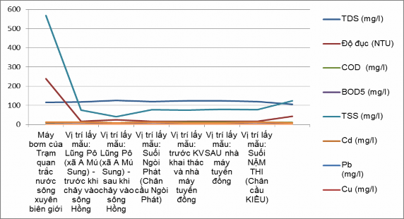
Figure 3.3: Red River surface water quality chart at monitoring points from upstream to downstream, flowing through Lao Cai province
Water quality of the Red River at Lung Po: Lung Po is the first point where the Red River meets Vietnamese territory, the sampling location is where the flow flows straight from China to Vietnam. Measurements and analysis of Red River water samples at Lung Po show that the river water is polluted by TSS, Organic matter, Ammonia, Nitrite, Lead, and Arsenic.
Red River water quality at Ban Vuoc: The sampling location of Red River water at Ban Vuoc is located about 1 km downstream of the Ngoi Phat stream joining the Red River. Ngoi Phat stream flows through the area where Dong Sinh Quyen mining activities are taking place in Ban Vuoc commune, Bat Xat district. Red River water at Ban Vuoc is polluted by TSS, Pb, Cu, As, and high levels of organochlorine and phosphorus pesticides.
Water quality of the Red River at Coc Leu Bridge: Through Ban Vuoc, the Red River continues to flow towards Lao Cai City, the section from Ban Vuoc to Coc Leu Bridge is joined by Ngoi Xan (Quang Kim Commune) and many small streams, then flows through the border between Ha Khau Town (China) and Lao Cai City, affected by domestic wastewater. The results show that the river water is polluted by TSS, ammonia, nitrite, As, Pb, Cu and total residues of plant protection chemicals Cl - and PO 4 3- .
b) Red River sediment quality
The analysis results are presented specifically in Table 3.13 below:
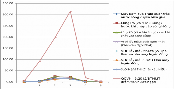
Figure 3.4: Sediment quality chart of the Red River, flowing through Lao Cai province, at different monitoring points
*) Comment : The analysis results show that the content of Cd, Pb, Cu, Zn, Fe, As is within the safe range, much smaller than QCVN 43:2012/BTNMT - National technical regulation on sediment quality, however there are complex developments between monitoring points.
Table 3.13: Sediment quality of the Red River at monitoring points in 2015
Status
Station | CD (mg/kg) | Pb (mg/kg) | Cu (mg/kg) | Zn (mg/kg) | As (mg/kg) | Hg (mg/kg) | |
1 | Pumps of the Transboundary River Water Monitoring Station | 0.62 | 1.97 | 21.60 | 20.84 | 0.83 | 0.01 |
2 | Lung Po (A Mu Sung commune) - before flowing into the Red River | 0.86 | 3.04 | 23.66 | 20.56 | 1.49 | 0.05 |
3 | Lung Po (A Mu Sung commune) - after flowing into the Red River | 0.74 | 2.62 | 22.90 | 20.74 | 1.37 | 0.04 |
4 | Sampling location: Ngoi Phat Stream (Foot of Ngoi Phat Bridge) | 0.444 | 1,601 | 16,704 | 17,271 | 0.037 | 0.011 |
5 | Sampling location: in front of mining area and copper processing plant | 0.365 | 1,143 | 14,261 | 12,696 | 0.025 | 0.012 |
6 | Sampling location: After Copper Plant | 0.28 | 0.59 | 10.88 | 14.49 | 0.03 | 0.01 |
7 | Nam Thi Stream (Foot of Kieu Bridge) | 0.35 | 1.05 | 13.75 | 13.45 | 0.03 | 0.01 |
QCVN 43:2012/BTNMT (freshwater sediment) | 3.5 | 91.3 | 197 | 315 | 17.0 | 0.5 | |
Maybe you are interested!
-
 Water security and access to clean water for people in the Red River Delta - Current situation and solutions - 1
 -
 Assessment of the Current Status of Water Sources Directly Affecting the Thuong River Flowing Through Bac Giang Province.
 -
 Location, Water Quality Monitoring Points of Dong Nai River Basin
 -
 Objective of Industrialization and Modernization of the Red River Delta by 2020
 -
 Assessment of surface water resources in Dong Nai river basin to serve sustainable development goals in the context of climate change - 2
42
3.1.4. Causes of changes in water quality of the Red River flowing through Lao Cai province
The change in water quality of the Red River is an inevitable consequence of two types of activities: natural and artificial. To effectively manage and protect the water environment of the Red River, it is extremely important to identify the causes of pollution. Especially, with a river as international as the Red River, the causes of transnational pollution need to be carefully considered. The main source of pollution is the discharge of wastewater from agricultural, aquaculture, industrial production, and domestic wastewater that has not been treated or has not been treated to the permitted standards into the river system.
Pollution caused by industrial wastewater: According to the planning for the development of industrial zones in the province by 2025, the whole province has 03 industrial zones and clusters with a total area of 1,160 hectares (Dong Pho Moi Industrial Park 80 hectares, Bac Duyen Hai Industrial Park 80 hectares, Tang Loong Industrial Park 1,000 hectares). Currently, Lao Cai province has Dong Pho Moi Industrial Park and Tang Loong Industrial Park approved by the Government, the rest is Bac Duyen Hai Industrial Cluster.
Currently, the environmental protection infrastructure in the zones and clusters is not synchronous, moreover, there are many industrial production facilities in the zones and clusters, so it is inevitable that there will be a resonance effect. The development of industry, its downside is environmental pollution. Industrial production and processing facilities inside and outside the industrial zones and clusters when investing must ensure legal procedures and invest in environmental treatment facilities. Waste generated during the production process is discharged into the receiving environment after being treated. In particular, most of the wastewater after being treated is discharged into the river system around the area, from there flowing into the Red River.
Thus, this is also one of the sources affecting the water quality of the Red River flowing through Lao Cai province. The treatment, inspection and strict monitoring of wastewater treatment activities before discharging into the environment of industrial production facilities is an urgent requirement and needs to be given top priority at the present time.
Source of pollution from domestic wastewater: The population of Lao Cai province is
665,152 people as of 2014, average population density is 95 people/km 2 , population
The distribution is sparse, so the level of pollution from households is insignificant. The whole province has 4 provincial hospitals and all communes and wards have medical stations. Wastewater from hospitals is a source of pollution that needs attention.
The largest and most concentrated domestic wastewater is in Lao Cai city, estimated at about 11,175 m 3 /day and night (calculated based on the city's population of 74,500 people with water usage of about 150 liters / person / day and night), that is 4,078,875 m 3 /year. The remaining domestic wastewater from residential clusters of communes and towns into the river system, from which flows into the Red River is not much because most residential areas do not have a centralized wastewater reception system, wastewater is collected into individual sewers and ditches and then discharged into the canal system, ponds and lakes in the residential area. On the other hand, domestic wastewater of residents in Ha Khau district, China is not treated before being discharged into the Red River.
The Red River is one of the main objects in the province that must regularly receive domestic wastewater, all of which are untreated or only preliminarily treated by septic tanks. Not only does it directly receive domestic wastewater, but it also plays a role as a water supply for the wastewater drainage system of rivers and streams in the province. At the time of change in flow, the river water level drops, in the past time the weather in Vietnam and China has not had prolonged rain, causing the river water flow to decrease, the upstream hydroelectric dams store water, leading to the situation of low flow and water level of the Red River, the amount of water and domestic sludge is not circulated, increasing the possibility of river water pollution. When the water level of the Red River drops, the riverbanks and riverbed still retain sludge, the dilution decreases, causing eutrophication, oxidation of the mud at the bottom and riverbanks, leading to the generation of foul odors from decomposing organic matter.
Pollution caused by chemicals in agricultural production: In addition to its role as a water supply, the Red River also plays a very important role as the main drainage axis in Lao Cai province. The total agricultural land area of Lao Cai province is 76,930 hectares, of which the cultivated land using chemicals to prevent pests (rice land, corn land and vegetable land) is 4,884 hectares. The amount of agricultural chemicals
The use of industrial chemicals (fertilizers, pesticides) is not much. There is currently no assessment of the impact of the use of fertilizers and pesticides on the quality of surface water and groundwater. But this is also one of the major risks, causing pollution of the Red River water environment is only a matter of time if there are no timely measures to handle it.
3.2. Current status of the monitoring network for environmental pollution warning of the Red River flowing through Lao Cai province
3.2.1. State management system for monitoring and warning of environmental pollution of the Red River flowing through Lao Cai province
Lao Cai Department of Natural Resources and Environment
Lao Cai Environmental Protection Department
Lao Cai Environmental Monitoring Center
Figure 3.5: State management system for monitoring and warning of water pollution in the Red River section flowing through Lao Cai province
a) Department of Natural Resources and Environment of Lao Cai province :
The position, functions, tasks, powers and organizational structure of the Department of Natural Resources and Environment of Lao Cai province are stipulated in Decision No. 09/2015/QD-UBND dated February 25, 2015 of the People's Committee of Lao Cai province . Accordingly, the Department of Natural Resources and Environment is a specialized agency under the Provincial People's Committee, advising the Provincial People's Committee on state management of natural resources and environment, including management and control of pollution of water sources. The components of the Red River water environment in Lao Cai province are monitored at sensitive points and areas affected by activities.
of humans as well as fluctuations in nature. These monitoring points have been built, researched, supplemented and expanded by the Lao Cai Department of Natural Resources and Environment over the years.
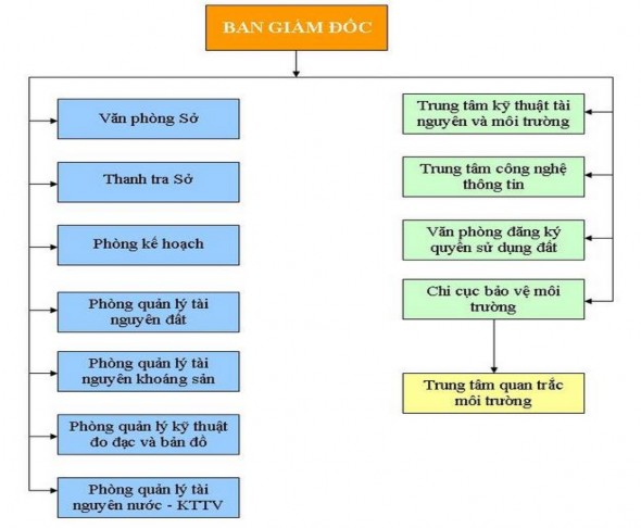
Figure 3.6: Organizational chart of the Department of Natural Resources and Environment of Lao Cai province
b) Lao Cai Provincial Department of Environmental Protection
The functions, tasks and powers of the Lao Cai Provincial Environmental Protection Department are stipulated in Decision No. 3977/QD-UBND dated December 23, 2008 of the Lao Cai Provincial People's Committee. It is a unit under the Department of Natural Resources and Environment, advising the Director of the Department on state management in the fields of monitoring, inspection, supervision, prevention of pollution, degradation, and environmental incidents; improving environmental quality,