Hinh River | ||||||
16 | Ho Xuan Smell | 1,637 | 686 | 640 | 3 | TB |
17 | H'Ly Waterfall | 2,469 | 1,035 | 842 | 4 | Sizable |
Maybe you are interested!
-

 Identify Rating Levels and Rating Scales
zt2i3t4l5ee
zt2a3gstourism,quan lan,quang ninh,ecology,ecotourism,minh chau,van don,geography,geographical basis,tourism development,science
zt2a3ge
zc2o3n4t5e6n7ts
of the islanders. Therefore, this indicator will be divided into two sub-indicators:
a1. Natural tourism attractiveness a2. Cultural tourism attractiveness
b. Tourist capacity
The two island communes in Quan Lan have different capacities to receive tourists. Minh Chau Commune is home to many standard hotels and resorts, attracting high-income domestic and international tourists. Meanwhile, Quan Lan Commune has many motels mainly built and operated by local people, so the scale and quality are not high, and will be suitable for ordinary tourists such as students.
c. Time of exploitation of Quan Lan Island Commune:
Quan Lan tourism is seasonal due to weather and climate conditions and festivals only take place on certain days of the year, specifically in spring. In Quan Lan commune, the period from April to June and from September to November is considered the best time to visit Quan Lan because the cultural tourism activities are mainly associated with festivals taking place during this time.
Minh Chau island commune:
Tourism exploitation time is all year round, because this is a place with a number of tourist attractions with diverse ecosystems such as Bai Tu Long National Park Research Center, Tram forest, Turtle Laying Beach, so besides coming to the beach for tourism and vacation in the summer, Minh Chau will attract research groups to come for tourism combined with research at other times of the year.
d. Sustainability
The sustainability of ecotourism sites in Quan Lan and Minh Chau communes depends on the sensitivity of the ecosystems to climate changes.
landscape. In general, these tourist destinations have a fairly high level of sustainability, because they are natural ecosystems, planned and protected. However, if a large number of tourists gather at certain times, it can exceed the carrying capacity and affect the sustainability of the environment (polluted beaches, damaged trees, animals moving away from their habitats, etc.), then the sustainability of the above ecosystems (natural ecosystems, human ecosystems) will also be affected and become less sustainable.
e. Location and accessibility
Both island communes have ports to take tourists to visit from Van Don wharf:
- Quan Lan – Van Don traffic route:
Phuc Thinh – Viet Anh high-speed boat and Quang Minh high-speed boat, depart at 8am and 2pm from Van Don to Quan Lan, and at 7am and 1pm from Quan Lan to Van Don. There are also wooden boats departing at 7am and 1pm.
- Van Don - Minh Chau traffic route:
Chung Huong high-speed train, Minh Chau train, morning 7:30 and afternoon 13:30 from Van Don to Minh Chau, morning 6:30 and afternoon 13:00 from Minh Chau to Van Don.
f. Infrastructure
Despite receiving investment attention, the issue of infrastructure and technical facilities for tourism on Quan Lan Island is still an issue that needs to be resolved because it has a direct impact on the implementation of ecotourism activities. The minimum conditions for serving tourists such as accommodation, electricity, water, communication, especially medical services, and security work need to be given top priority. Ecotourism spots in Minh Chau commune are assessed to have better infrastructure and technical facilities for tourism because there are quite complete and synchronous conditions for serving tourists, meeting many needs of domestic and foreign tourists.
3.2.1.4. Determine assessment levels and assessment scales
Corresponding to the levels of each criterion, the index is the score of those levels in the order of 4, 3, 2, 1 decreasing according to the standard of each level: very attractive (4), attractive (3), average (2), less attractive (1).
3.2.1.5. Determining the coefficients of the criteria
For the assessment of DLST in the two communes of Quan Lan and Minh Chau islands, the students added evaluation coefficients to show the importance of the criteria and indicators as follows:
Coefficient 3 with criteria: Attractiveness, Exploitation time. These are the 2 most important criteria for attracting tourists to tourism in general and eco-tourism in particular, so they have the highest coefficient.
Coefficient 2 with criteria: Capacity, Infrastructure, Location and accessibility . Because the assessment area is an island commune of Van Don district, the above criteria are selected by the author with appropriate coefficients at the average level.
Coefficient 1 with criteria: Sustainability. Quan Lan has natural and human-made ecotourism sites, with high biodiversity and little impact from local human factors. Most of the ecotourism sites are still wild, so they are highly sustainable.
3.2.1.6. Results of DLST assessment on Quan Lan island
a. Assessment of the potential for natural tourism development
For Minh Chau commune:
+ Natural tourism attractiveness is determined to be very attractive (4 points) and the most important coefficient (coefficient 3), so the score of the Attractiveness criterion is 4 x 3 = 12.
+ Capacity is determined as average (2 points) and the coefficient is quite important (coefficient 2), then the score of Capacity criterion is 2 x 2 = 4.
+ Exploitation time is long (4 points), the most important coefficient (coefficient 3) so the score of the Exploitation time criterion is 4 x 3 = 12.
+ Sustainability is determined as sustainable (4 points), the important coefficient is the average coefficient (coefficient 1), so the score of the Sustainability criterion is 4 x 1 = 4 points
+ Location and accessibility are determined to be quite favorable (2 points), the coefficient is quite important (coefficient 2), the criterion score is 2 x 2 = 4 points.
+ Infrastructure is assessed as good (3 points), the coefficient is quite important (coefficient 2), then the score of the Infrastructure criterion is 3 x 2 = 6 points.
The total score for evaluating DLST in Minh Chau commune according to 6 evaluation criteria is determined as: 12 + 4 + 12 + 4 + 4 + 6 = 42 points
Similar assessment for Quan Lan commune, we have the following table:
Table 3.3: Assessment of the potential for natural ecotourism development in Quan Lan and Minh Chau communes
Attractiveness of self-tourismof course
Capacity
Mining time
Sustainability
Location and accessibility
Infrastructure
Result
Point
DarkMulti
Point
DarkMulti
Point
DarkMulti
Point
DarkMulti
Point
DarkMulti
Point
DarkMulti
CommuneMinh Chau
12
12
4
8
12
12
4
4
4
8
6
8
42/52
Quan CommuneLan
6
12
6
8
9
12
4
4
4
8
4
8
33/52
b. Assessment of the potential for humanistic tourism development
For Quan Lan commune:
+ The attractiveness of human tourism is determined to be very attractive (4 points) and the most important coefficient (coefficient 3), so the score of the Attractiveness criterion is 4 x 3 = 12.
+ Capacity is determined to be large (3 points) and the coefficient is quite important (coefficient 2), then the score of the Capacity criterion is 3 x 2 = 6.
+ Mining time is average (3 points), the most important coefficient (coefficient 3) so the score of the Mining time criterion is 3 x 3 = 9.
+ Sustainability is determined as sustainable (4 points), the important coefficient is the average coefficient (coefficient 1), so the score of the Sustainability criterion is 4 x 1 = 4 points.
+ Location and accessibility are determined to be quite favorable (2 points), the coefficient is quite important (coefficient 2), the criterion score is 2 x 2 = 4 points.
+ Infrastructure is rated as average (2 points), the coefficient is quite important (coefficient 2), then the score of the Infrastructure criterion is 2 x 2 = 4 points.
The total score for evaluating DLST in Quan Lan commune according to 6 evaluation criteria is determined as: 12 + 6 + 6 + 4 + 4 + 4 = 36 points.
Similar assessment with Minh Chau commune we have the following table:
Table 3.4: Assessment of the potential for developing humanistic eco-tourism in Quan Lan and Minh Chau communes
Attractiveness of human tourismliterature
Capacity
Mining time
Sustainability
Location and accessibility
Infrastructure
Result
Point
DarkMulti
Point
DarkMulti
Point
DarkMulti
Point
DarkMulti
Point
DarkMulti
Point
DarkMulti
Quan CommuneLan
12
12
6
8
9
12
4
4
4
8
4
8
39/52
Minh CommuneChau
6
12
4
8
12
12
4
4
4
8
6
8
36/52
Basically, both Minh Chau and Quan Lan localities have quite favorable conditions for developing ecotourism. However, Quan Lan commune has more advantages to develop ecotourism in a humanistic direction, because this is an area with many famous historical relics such as Quan Lan Communal House, Quan Lan Pagoda, Temple worshiping the hero Tran Khanh Du, ... along with local festivals held annually such as the wind praying ceremony (March 15), Quan Lan festival (June 10-19); due to its location near the port and long exploitation time, the beaches in Quan Lan commune (especially Quan Lan beach) are no longer hygienic and clean to ensure the needs of tourists coming to relax and swim; this is also an area with many beautiful landscapes such as Got Beo wind pass, Ong Phong head, Voi Voi cave, but the ability to access these places is still very limited (dirt hill road, lots of gravel and rocks), especially during rainy and windy times; In addition, other natural resources such as mangrove forests and sea worms have not been really exploited for tourism purposes and ecotourism development. On the contrary, Minh Chau commune has more advantages in developing ecotourism in the direction of natural tourism, this is an area with diverse ecosystems such as at Rua De Beach, Bai Tu Long National Park Conservation Center...; Minh Chau beach is highly appreciated for its natural beauty and cleanliness, ranked in the top ten most beautiful beaches in Vietnam; Minh Chau commune is also home to Tram forest with a large area and a purity of up to 90%, suitable for building bridges through the forest (a very effective type of natural ecotourism currently applied by many countries) for tourists to sightsee, as well as for the purpose of studying and researching.
Figure 3.1: Thenmala Forest Bridge (India) Source: https://www.thenmalaecotourism.com/(August 21, 2019)
3.2.2. Using SWOT matrix to evaluate Quan Lan island tourism
General assessment of current tourism activities of Quan Lan island is shown through the following SWOT matrix:
Table 3.5: SWOT matrix evaluating tourism activities on Quan Lan island
Internal agent
Strengths- There is a lot of potential for tourism development, especially natural ecotourism and humanistic ecotourism.- The unskilled labor force is relatively abundant.- resource environmentunpolluted, still
Weaknesses- Poorly developed infrastructure, especially traffic routes to tourist destinations on the island.- The team of professional staff is still weak.- Tourism products in general
quite wild, originalintact
general and DLST in particularalone is monotonous.
External agents
Opportunity- Tourism is a key industry in the socio-economic development strategy of the province and Van Don economic zone.- Quan Lan was selected as a pilot area for eco-tourism development within the framework of the green growth project between Quang Ninh province and the Japanese organization JICA.- The flow of tourists and especially ecotourism in the world tends toincreasing
Challenge- Weather and climate change abnormally.- Competition in tourism products is increasingly fierce, especially with other localities in the province such as Ha Long, Mong Cai...- Awareness of tourists, especially domestic tourists, about ecotourism and nature conservation is not high.
Through summary analysis using SWOT matrix we see that:
To exploit strengths and take advantage of opportunities, it is necessary to:
- Diversify products and service types (build more tourism routes aimed at specific needs of tourists: experiential tourism immersed in nature, spiritual cultural tourism...)
- Effective exploitation of resources and differentiated products (natural resources and human resources)
div.maincontent .p { color: black; font-family:"Times New Roman", serif; font-style: normal; font-weight: normal; text-decoration: none; font-size: 14pt; margin:0pt; } div.maincontent p { color: black; font-family:"Times New Roman", serif; font-style: normal; font-weight: normal; text-decoration: none; font-size: 14pt; margin:0pt; } div.maincontent .s1 { color: black; font-family:"Times New Roman", serif; font-style: normal; font-weight: normal; text-decoration: none; font-size: 13pt; } div.maincontent .s2 { color: black; font-family:"Times New Roman", serif; font-style: normal; font-weight: normal; text-decoration: none; font-size: 13pt; } div.maincontent .s3 { color: #0D0D0D; font-family:"Times New Roman", serif; font-style: normal; font-weight: bold; text-decoration: none; font-size: 14pt; } div.maincontent .s4 { color: black; font-family:"Times New Roman", serif; font-style: italic; font-weight: normal; text-decoration: none; font-size: 14pt; } div.maincontent .s5 { color: black; font-family:"Times New Roman", serif; font-style: italic; font-weight: bold; text-decoration: none; font-size: 14pt; } div.maincontent .s6 { color: black; font-family:"Times New Roman", serif; font-style: italic; font-weight: normal; text-decoration: none; font-size: 14pt; vertical-align: -3pt; } div.maincontent .s7 { color: black; font-family:"Times New Roman", serif; font-style: italic; font-weight: normal; text-decoration: none; font-size: 14pt; vertical-align: -2pt; } div.maincontent .s8 { color: black; font-family:"Times New Roman", serif; font-style: italic; font-weight: normal; text-decoration: none; font-size: 14pt; vertical-align: -1pt; } div.maincontent .s9 { color: black; font-family:"Times New Roman", serif; font-style: normal; font-weight: normal; text-decoration: none; font-size: 14pt; } div.maincontent .s10 { color: black; font-family:"Times New Roman", serif; font-style: normal; font-weight: bold; text-decoration: none; font-size: 14pt; } div.maincontent .s11 { color: black; font-family:"Times New Roman", serif; font-style: normal; font-weight: normal; text-decoration: none; font-size: 14pt; } div.maincontent .s12 { color: black; font-family:Symbol, serif; font-style: normal; font-weight: normal; text-decoration: none; font-size: 14pt; } div.maincontent .s13 { color: black; font-family:Wingdings; font-style: normal; font-weight: normal; text-decoration: none; font-size: 14pt; } div.maincontent .s14 { color: black; font-family:"Times New Roman", serif; font-style: normal; font-weight: normal; text-decoration: none; font-size: 9pt; vertical-align: 5pt; } div.maincontent .s15 { color: black; font-family:"Times New Roman", serif; font-style: normal; font-weight: normal; text-decoration: none; font-size: 9pt; vertical-align: 5pt; } div.maincontent .s16 { color: black; font-family:Cambria, serif; font-style: italic; font-weight: normal; text-decoration: none; font-size: 14pt; } div.maincontent .s17 { color: #080808; font-family:"Times New Roman", serif; font-style: normal; font-weight: bold; text-decoration: none; font-size: 14pt; } div.maincontent .s18 { color: #080808; font-family:"Times New Roman", serif; font-style: normal; font-weight: normal; text-decoration: none; font-size: 14pt; } div.maincontent .s19 { color: black; font-family:"Times New Roman", serif; font-style: normal; font-weight: normal; text-decoration: none; font-size: 11pt; } div.maincontent .s20 { color: black; font-family:"Times New Roman", serif; font-style: normal; font-weight: normal; text-decoration: none; font-size: 10pt; } div.maincontent .s21 { color: black; font-family:"Times New Roman", serif; font-style: normal; font-weight: bold; text-decoration: none; font-size: 11pt; } div.maincontent .s22 { color: black; font-family:"Times New Roman", serif; font-style: normal; font-weight: normal; text-decoration: none; font-size: 11pt; } div.maincontent .s23 { color: black; font-family:"Times New Roman", serif; font-style: italic; font-weight: normal; text-decoration: none; font-size: 14pt; } div.maincontent .s24 { color: #212121; font-family:"Times New Roman", serif; font-style: normal; font-weight: normal; tex
Identify Rating Levels and Rating Scales
zt2i3t4l5ee
zt2a3gstourism,quan lan,quang ninh,ecology,ecotourism,minh chau,van don,geography,geographical basis,tourism development,science
zt2a3ge
zc2o3n4t5e6n7ts
of the islanders. Therefore, this indicator will be divided into two sub-indicators:
a1. Natural tourism attractiveness a2. Cultural tourism attractiveness
b. Tourist capacity
The two island communes in Quan Lan have different capacities to receive tourists. Minh Chau Commune is home to many standard hotels and resorts, attracting high-income domestic and international tourists. Meanwhile, Quan Lan Commune has many motels mainly built and operated by local people, so the scale and quality are not high, and will be suitable for ordinary tourists such as students.
c. Time of exploitation of Quan Lan Island Commune:
Quan Lan tourism is seasonal due to weather and climate conditions and festivals only take place on certain days of the year, specifically in spring. In Quan Lan commune, the period from April to June and from September to November is considered the best time to visit Quan Lan because the cultural tourism activities are mainly associated with festivals taking place during this time.
Minh Chau island commune:
Tourism exploitation time is all year round, because this is a place with a number of tourist attractions with diverse ecosystems such as Bai Tu Long National Park Research Center, Tram forest, Turtle Laying Beach, so besides coming to the beach for tourism and vacation in the summer, Minh Chau will attract research groups to come for tourism combined with research at other times of the year.
d. Sustainability
The sustainability of ecotourism sites in Quan Lan and Minh Chau communes depends on the sensitivity of the ecosystems to climate changes.
landscape. In general, these tourist destinations have a fairly high level of sustainability, because they are natural ecosystems, planned and protected. However, if a large number of tourists gather at certain times, it can exceed the carrying capacity and affect the sustainability of the environment (polluted beaches, damaged trees, animals moving away from their habitats, etc.), then the sustainability of the above ecosystems (natural ecosystems, human ecosystems) will also be affected and become less sustainable.
e. Location and accessibility
Both island communes have ports to take tourists to visit from Van Don wharf:
- Quan Lan – Van Don traffic route:
Phuc Thinh – Viet Anh high-speed boat and Quang Minh high-speed boat, depart at 8am and 2pm from Van Don to Quan Lan, and at 7am and 1pm from Quan Lan to Van Don. There are also wooden boats departing at 7am and 1pm.
- Van Don - Minh Chau traffic route:
Chung Huong high-speed train, Minh Chau train, morning 7:30 and afternoon 13:30 from Van Don to Minh Chau, morning 6:30 and afternoon 13:00 from Minh Chau to Van Don.
f. Infrastructure
Despite receiving investment attention, the issue of infrastructure and technical facilities for tourism on Quan Lan Island is still an issue that needs to be resolved because it has a direct impact on the implementation of ecotourism activities. The minimum conditions for serving tourists such as accommodation, electricity, water, communication, especially medical services, and security work need to be given top priority. Ecotourism spots in Minh Chau commune are assessed to have better infrastructure and technical facilities for tourism because there are quite complete and synchronous conditions for serving tourists, meeting many needs of domestic and foreign tourists.
3.2.1.4. Determine assessment levels and assessment scales
Corresponding to the levels of each criterion, the index is the score of those levels in the order of 4, 3, 2, 1 decreasing according to the standard of each level: very attractive (4), attractive (3), average (2), less attractive (1).
3.2.1.5. Determining the coefficients of the criteria
For the assessment of DLST in the two communes of Quan Lan and Minh Chau islands, the students added evaluation coefficients to show the importance of the criteria and indicators as follows:
Coefficient 3 with criteria: Attractiveness, Exploitation time. These are the 2 most important criteria for attracting tourists to tourism in general and eco-tourism in particular, so they have the highest coefficient.
Coefficient 2 with criteria: Capacity, Infrastructure, Location and accessibility . Because the assessment area is an island commune of Van Don district, the above criteria are selected by the author with appropriate coefficients at the average level.
Coefficient 1 with criteria: Sustainability. Quan Lan has natural and human-made ecotourism sites, with high biodiversity and little impact from local human factors. Most of the ecotourism sites are still wild, so they are highly sustainable.
3.2.1.6. Results of DLST assessment on Quan Lan island
a. Assessment of the potential for natural tourism development
For Minh Chau commune:
+ Natural tourism attractiveness is determined to be very attractive (4 points) and the most important coefficient (coefficient 3), so the score of the Attractiveness criterion is 4 x 3 = 12.
+ Capacity is determined as average (2 points) and the coefficient is quite important (coefficient 2), then the score of Capacity criterion is 2 x 2 = 4.
+ Exploitation time is long (4 points), the most important coefficient (coefficient 3) so the score of the Exploitation time criterion is 4 x 3 = 12.
+ Sustainability is determined as sustainable (4 points), the important coefficient is the average coefficient (coefficient 1), so the score of the Sustainability criterion is 4 x 1 = 4 points
+ Location and accessibility are determined to be quite favorable (2 points), the coefficient is quite important (coefficient 2), the criterion score is 2 x 2 = 4 points.
+ Infrastructure is assessed as good (3 points), the coefficient is quite important (coefficient 2), then the score of the Infrastructure criterion is 3 x 2 = 6 points.
The total score for evaluating DLST in Minh Chau commune according to 6 evaluation criteria is determined as: 12 + 4 + 12 + 4 + 4 + 6 = 42 points
Similar assessment for Quan Lan commune, we have the following table:
Table 3.3: Assessment of the potential for natural ecotourism development in Quan Lan and Minh Chau communes
Attractiveness of self-tourismof course
Capacity
Mining time
Sustainability
Location and accessibility
Infrastructure
Result
Point
DarkMulti
Point
DarkMulti
Point
DarkMulti
Point
DarkMulti
Point
DarkMulti
Point
DarkMulti
CommuneMinh Chau
12
12
4
8
12
12
4
4
4
8
6
8
42/52
Quan CommuneLan
6
12
6
8
9
12
4
4
4
8
4
8
33/52
b. Assessment of the potential for humanistic tourism development
For Quan Lan commune:
+ The attractiveness of human tourism is determined to be very attractive (4 points) and the most important coefficient (coefficient 3), so the score of the Attractiveness criterion is 4 x 3 = 12.
+ Capacity is determined to be large (3 points) and the coefficient is quite important (coefficient 2), then the score of the Capacity criterion is 3 x 2 = 6.
+ Mining time is average (3 points), the most important coefficient (coefficient 3) so the score of the Mining time criterion is 3 x 3 = 9.
+ Sustainability is determined as sustainable (4 points), the important coefficient is the average coefficient (coefficient 1), so the score of the Sustainability criterion is 4 x 1 = 4 points.
+ Location and accessibility are determined to be quite favorable (2 points), the coefficient is quite important (coefficient 2), the criterion score is 2 x 2 = 4 points.
+ Infrastructure is rated as average (2 points), the coefficient is quite important (coefficient 2), then the score of the Infrastructure criterion is 2 x 2 = 4 points.
The total score for evaluating DLST in Quan Lan commune according to 6 evaluation criteria is determined as: 12 + 6 + 6 + 4 + 4 + 4 = 36 points.
Similar assessment with Minh Chau commune we have the following table:
Table 3.4: Assessment of the potential for developing humanistic eco-tourism in Quan Lan and Minh Chau communes
Attractiveness of human tourismliterature
Capacity
Mining time
Sustainability
Location and accessibility
Infrastructure
Result
Point
DarkMulti
Point
DarkMulti
Point
DarkMulti
Point
DarkMulti
Point
DarkMulti
Point
DarkMulti
Quan CommuneLan
12
12
6
8
9
12
4
4
4
8
4
8
39/52
Minh CommuneChau
6
12
4
8
12
12
4
4
4
8
6
8
36/52
Basically, both Minh Chau and Quan Lan localities have quite favorable conditions for developing ecotourism. However, Quan Lan commune has more advantages to develop ecotourism in a humanistic direction, because this is an area with many famous historical relics such as Quan Lan Communal House, Quan Lan Pagoda, Temple worshiping the hero Tran Khanh Du, ... along with local festivals held annually such as the wind praying ceremony (March 15), Quan Lan festival (June 10-19); due to its location near the port and long exploitation time, the beaches in Quan Lan commune (especially Quan Lan beach) are no longer hygienic and clean to ensure the needs of tourists coming to relax and swim; this is also an area with many beautiful landscapes such as Got Beo wind pass, Ong Phong head, Voi Voi cave, but the ability to access these places is still very limited (dirt hill road, lots of gravel and rocks), especially during rainy and windy times; In addition, other natural resources such as mangrove forests and sea worms have not been really exploited for tourism purposes and ecotourism development. On the contrary, Minh Chau commune has more advantages in developing ecotourism in the direction of natural tourism, this is an area with diverse ecosystems such as at Rua De Beach, Bai Tu Long National Park Conservation Center...; Minh Chau beach is highly appreciated for its natural beauty and cleanliness, ranked in the top ten most beautiful beaches in Vietnam; Minh Chau commune is also home to Tram forest with a large area and a purity of up to 90%, suitable for building bridges through the forest (a very effective type of natural ecotourism currently applied by many countries) for tourists to sightsee, as well as for the purpose of studying and researching.
Figure 3.1: Thenmala Forest Bridge (India) Source: https://www.thenmalaecotourism.com/(August 21, 2019)
3.2.2. Using SWOT matrix to evaluate Quan Lan island tourism
General assessment of current tourism activities of Quan Lan island is shown through the following SWOT matrix:
Table 3.5: SWOT matrix evaluating tourism activities on Quan Lan island
Internal agent
Strengths- There is a lot of potential for tourism development, especially natural ecotourism and humanistic ecotourism.- The unskilled labor force is relatively abundant.- resource environmentunpolluted, still
Weaknesses- Poorly developed infrastructure, especially traffic routes to tourist destinations on the island.- The team of professional staff is still weak.- Tourism products in general
quite wild, originalintact
general and DLST in particularalone is monotonous.
External agents
Opportunity- Tourism is a key industry in the socio-economic development strategy of the province and Van Don economic zone.- Quan Lan was selected as a pilot area for eco-tourism development within the framework of the green growth project between Quang Ninh province and the Japanese organization JICA.- The flow of tourists and especially ecotourism in the world tends toincreasing
Challenge- Weather and climate change abnormally.- Competition in tourism products is increasingly fierce, especially with other localities in the province such as Ha Long, Mong Cai...- Awareness of tourists, especially domestic tourists, about ecotourism and nature conservation is not high.
Through summary analysis using SWOT matrix we see that:
To exploit strengths and take advantage of opportunities, it is necessary to:
- Diversify products and service types (build more tourism routes aimed at specific needs of tourists: experiential tourism immersed in nature, spiritual cultural tourism...)
- Effective exploitation of resources and differentiated products (natural resources and human resources)
div.maincontent .p { color: black; font-family:"Times New Roman", serif; font-style: normal; font-weight: normal; text-decoration: none; font-size: 14pt; margin:0pt; } div.maincontent p { color: black; font-family:"Times New Roman", serif; font-style: normal; font-weight: normal; text-decoration: none; font-size: 14pt; margin:0pt; } div.maincontent .s1 { color: black; font-family:"Times New Roman", serif; font-style: normal; font-weight: normal; text-decoration: none; font-size: 13pt; } div.maincontent .s2 { color: black; font-family:"Times New Roman", serif; font-style: normal; font-weight: normal; text-decoration: none; font-size: 13pt; } div.maincontent .s3 { color: #0D0D0D; font-family:"Times New Roman", serif; font-style: normal; font-weight: bold; text-decoration: none; font-size: 14pt; } div.maincontent .s4 { color: black; font-family:"Times New Roman", serif; font-style: italic; font-weight: normal; text-decoration: none; font-size: 14pt; } div.maincontent .s5 { color: black; font-family:"Times New Roman", serif; font-style: italic; font-weight: bold; text-decoration: none; font-size: 14pt; } div.maincontent .s6 { color: black; font-family:"Times New Roman", serif; font-style: italic; font-weight: normal; text-decoration: none; font-size: 14pt; vertical-align: -3pt; } div.maincontent .s7 { color: black; font-family:"Times New Roman", serif; font-style: italic; font-weight: normal; text-decoration: none; font-size: 14pt; vertical-align: -2pt; } div.maincontent .s8 { color: black; font-family:"Times New Roman", serif; font-style: italic; font-weight: normal; text-decoration: none; font-size: 14pt; vertical-align: -1pt; } div.maincontent .s9 { color: black; font-family:"Times New Roman", serif; font-style: normal; font-weight: normal; text-decoration: none; font-size: 14pt; } div.maincontent .s10 { color: black; font-family:"Times New Roman", serif; font-style: normal; font-weight: bold; text-decoration: none; font-size: 14pt; } div.maincontent .s11 { color: black; font-family:"Times New Roman", serif; font-style: normal; font-weight: normal; text-decoration: none; font-size: 14pt; } div.maincontent .s12 { color: black; font-family:Symbol, serif; font-style: normal; font-weight: normal; text-decoration: none; font-size: 14pt; } div.maincontent .s13 { color: black; font-family:Wingdings; font-style: normal; font-weight: normal; text-decoration: none; font-size: 14pt; } div.maincontent .s14 { color: black; font-family:"Times New Roman", serif; font-style: normal; font-weight: normal; text-decoration: none; font-size: 9pt; vertical-align: 5pt; } div.maincontent .s15 { color: black; font-family:"Times New Roman", serif; font-style: normal; font-weight: normal; text-decoration: none; font-size: 9pt; vertical-align: 5pt; } div.maincontent .s16 { color: black; font-family:Cambria, serif; font-style: italic; font-weight: normal; text-decoration: none; font-size: 14pt; } div.maincontent .s17 { color: #080808; font-family:"Times New Roman", serif; font-style: normal; font-weight: bold; text-decoration: none; font-size: 14pt; } div.maincontent .s18 { color: #080808; font-family:"Times New Roman", serif; font-style: normal; font-weight: normal; text-decoration: none; font-size: 14pt; } div.maincontent .s19 { color: black; font-family:"Times New Roman", serif; font-style: normal; font-weight: normal; text-decoration: none; font-size: 11pt; } div.maincontent .s20 { color: black; font-family:"Times New Roman", serif; font-style: normal; font-weight: normal; text-decoration: none; font-size: 10pt; } div.maincontent .s21 { color: black; font-family:"Times New Roman", serif; font-style: normal; font-weight: bold; text-decoration: none; font-size: 11pt; } div.maincontent .s22 { color: black; font-family:"Times New Roman", serif; font-style: normal; font-weight: normal; text-decoration: none; font-size: 11pt; } div.maincontent .s23 { color: black; font-family:"Times New Roman", serif; font-style: italic; font-weight: normal; text-decoration: none; font-size: 14pt; } div.maincontent .s24 { color: #212121; font-family:"Times New Roman", serif; font-style: normal; font-weight: normal; tex -
 Assessment Criteria for the Favorability of Location Criteria and Accessibility for Developing Dlstdvcđ
 -
 How to Rank Skills Assessment by Criteria, Component Skills
 -
 General Assessment of Human Resource Development in the Tourism Industry in Hanoi
 -
 General Assessment and Issues Regarding Human Resource Training and Use
Note: PCC - natural capacity; RCC - actual capacity; ECC - allowable capacity
3.1.2.4. Evaluation of tourism exploitation time criteria
The time for tourism exploitation is determined by the number of favorable days for tourism activities in a year and the number of days with the most suitable climate conditions for human health. (Weather data used for calculation is the average of 10 years, 2009 - 2018 - Appendix 2).
a. Evaluate the number of favorable days for tourism activities
* The number of favorable days for tourism is the number of days in a year (365 days) minus the days with unfavorable weather for tourism (including rainy days, stormy days, strong southwest wind days, foggy days, and stormy days). Determining unfavorable weather days for tourism is determined as follows:
- Number of rainy days and stormy rains: The rain in Phu Yen province is mainly due to tropical convergence and rain due to the influence of storms or tropical depressions, so the rain often occurs with high intensity, high water concentration and each rain period usually lasts from 03-05 days. With the type of rain with high water concentration, the average rainfall of 20mm/day will affect tourism activities. Therefore, the number of rainy days is determined to be unfavorable for tourism in Phu Yen territory is the day with an average rainfall of over 20mm.
- Number of stormy days: Stormy days in Phu Yen often occur in summer and autumn and winter. However, autumn and winter (from September) is the rainy season in Phu Yen, so stormy days are often accompanied by rain (seasonal transition), these days have been counted in the number of unfavorable days due to rain, so the calculation of the number of stormy days unfavorable for tourism is calculated before August.
- Number of days with strong dry and hot westerly winds: The strong dry and hot indicator is the absolute maximum daily temperature ≥37 o C, combined with the lowest relative humidity during the day ≤45%.
* The data used for calculation is the 10-year average data (from 2009 to 2018) of rain gauges and meteorological stations in Phu Yen province. The results of the observation stations near the observation stations will be used for calculation. The number of rain gauge stations in Phu Yen province is relatively densely distributed, so the calculation results of the number of rainy days of the rain gauge stations are highly accurate. The rain gauge stations used for calculation include Tuy Hoa, Phu Lac, Song Cau, Son Thanh, Ha Bang, Son Hoa.
However, for meteorological data (number of stormy days, strong foehn winds, fog), the calculation results are taken from two meteorological stations: Son Hoa station (used for TNTN points distributed in the West) and Tuy Hoa station (used for TNTN points distributed in the East), because Phu Yen province only has these two meteorological stations. The observation results of these two stations can be used to calculate for 17 TNTN points in the thesis for the following reasons:
- Phu Yen's territory is not large, the shape of the territory is generally balanced (87km long, about 72km widest place), the terrain is relatively clearly divided: the East is low plain terrain interspersed with hills and mountains; the West is hills, low mountains and plateaus. That is what creates the main climate differentiation according to the two mountainous regions in the West and the coastal region in the East, within the region the climate is not clearly differentiated.
- For the TNTN points in the eastern coastal area, the TNTN point selected for evaluation is located furthest from Tuy Hoa meteorological station, which is Tu Nham beach - Vinh Hoa (about 43km). As for the TNTN points selected for evaluation in the west, the resource point located furthest from Son Hoa station is Triem Duc mineral spring (more than 30km from the station). Thus, using data from 2 meteorological stations to calculate for TNTN points is appropriate (because according to regulations, the allowable accuracy is within a radius of 50km from the monitoring point).
- According to the interview results with experts at Tuy Hoa Hydrometeorological Station, meteorological observation data from Tuy Hoa and Son Hoa stations are used to calculate and forecast weather phenomena in the plains and mountainous areas of Phu Yen with high accuracy (over 80%). Therefore, data from these two stations are also used to calculate tourism development in the thesis.
The results of the evaluation of the number of favorable days for tourism activities by year are shown in Table 3.7.
b. Evaluate the number of days with climate suitable for human health
The number of days with a climate suitable for human health is calculated based on the average absolute humidity and average monthly temperature (Table 3.5 and Table 3.6), shown on the temperature-humidity diagram (Figures 3.7 and 3.8).
Table 3.5: Absolute humidity and average temperature of each month of the year at Tuy Hoa station
Month
Element
I | II | III | IV | V | VI | VII | VIII | IX | X | XI | XII | Year | |
Average absolute humidity (mb) | 24.7 | 24.6 | 26.9 | 29.9 | 31.3 | 29.5 | 29.1 | 29.3 | 30.2 | 29.4 | 29.8 | 26.2 | 28.5 |
Average temperature ( o C) | 23.5 | 24.2 | 25.7 | 27.8 | 29.3 | 29.9 | 29.3 | 29.5 | 28.5 | 26.8 | 26.0 | 24.5 | 24.9 |
Average lowest temperature ( o C)
21.1 | 21.4 | 22.6 | 24.2 | 25.4 | 26.1 | 25.8 | 25.6 | 24.8 | 24.1 | 23.3 | 22.0 | 23.9 | |
Average highest temperature ( o C) | 26.5 | 27.8 | 29.8 | 32.0 | 33.9 | 34.3 | 34.3 | 33.9 | 32.5 | 29.7 | 27.9 | 26.5 | 30.8 |
[Data provided by Tuy Hoa KT-TV Station]
Table 3.6: Absolute humidity and average temperature of each month of the year at Son Hoa station
Month
Element
I | II | III | IV | V | VI | VII | VIII | IX | X | XI | XII | Year | |
Average absolute humidity (mb) | 23.0 | 22.6 | 24.9 | 27.8 | 30.1 | 29.5 | 29.0 | 29.1 | 30.6 | 28.9 | 28.0 | 25.4 | 27.4 |
Average temperature ( o C) | 22.5 | 23.1 | 25.3 | 27.6 | 28.9 | 28.9 | 28.6 | 28.5 | 27.5 | 25.8 | 25.2 | 23.4 | 24.1 |
Average Lowest Temperature ( oC ) | 19.0 | 19.6 | 21.2 | 23.1 | 24.6 | 24.9 | 24.7 | 24.6 | 23.9 | 22.9 | 21.7 | 20.1 | 22.5 |
Average highest temperature ( o C) | 27.2 | 29.4 | 32.4 | 34.9 | 35.6 | 34.6 | 34.6 | 34.1 | 32.8 | 30.0 | 28.2 | 26.6 | 31.7 |
[Data provided by Tuy Hoa KT-TV Station]
The summary of the results of the assessment of the number of favorable days for tourism activities by year is shown in Table 3.7.
82
Table 3.7: Summary of results of evaluation of favorable days for tourism activities by year (Unit: Day)
TNTN Point
Element/monitoring station
Vinh Xuan Dai Bay | Ganh Da Dia | Hon Yen | O Dam Loan | Bai Mon - Mui Dai Lanh | Stone Mountain | Tu Nham Beach -Hoa Bay | Xep Beach | Mai Nha Island | Tuy Hoa Beach | Dong Cam Dam | Triem mineral spring Virtue | Van Hoa Plateau | Ba Ha Hydroelectric Reservoir | Song Hinh Hydroelectric Reservoir | Ho Xuan Huong | H'Ly Waterfall | |
Number of rainy and stormy days | 60.0 | 72.0 | 72.0 | 72.0 | 41.0 | 41.0 | 60.0 | 72.0 | 72.0 | 72.0 | 54.0 | 64.0 | 71.0 | 71.0 | 71.0 | 71.0 | 71.0 |
Number of stormy days | 25.5 | 25.5 | 25.5 | 25.5 | 25.5 | 25.5 | 25.5 | 25.5 | 25.5 | 25.5 | 71.8 | 71.8 | 71.8 | 71.8 | 71.8 | 71.8 | 71.8 |
Number of days with strong foehn wind | 2.0 | 2.0 | 2.0 | 2.0 | 2.0 | 2.0 | 2.0 | 2.0 | 2.0 | 2.0 | 15.0 | 15.0 | 15.0 | 15.0 | 15.0 | 15.0 | 15.0 |
Number of foggy days | 2.9 | 2.9 | 2.9 | 2.9 | 2.9 | 2.9 | 2.9 | 2.9 | 2.9 | 2.9 | 17.5 | 17.5 | 17.5 | 17.5 | 17.5 | 17.5 | 17.5 |
Number of unfavorable days for the contract | 90 | 102 | 102 | 102 | 71 | 71 | 90 | 102 | 102 | 102 | 158 | 168 | 175 | 175 | 175 | 175 | 175 |
Number of favorable days for HDDL | 275 | 263 | 263 | 263 | 294 | 294 | 275 | 263 | 263 | 263 | 207 | 197 | 190 | 190 | 190 | 190 | 190 |
(Note: 1/ Rainfall data of the TNTN points are calculated according to the following monitoring stations: Xuan Dai Bay, Tu Nham beach - Vinh Hoa (Song Cau rain gauge station); Ganh Da Dia, Hon Yen, O Loan lagoon, Bai Xep, Cu Lao Mai Nha, Tuy Hoa beach (Tuy Hoa rain gauge station); Bai Mon - Mui Dai Lanh, Da Bia mountain (Phu Lac rain gauge station); Dong Cam dam (Son Thanh rain gauge station); Triem Duc mineral spring (Ha Bang rain gauge station); Van Hoa plateau, Ba Ha hydroelectric lake, Song Hinh hydroelectric lake, Xuan Huong lake, H'Ly waterfall (Son Hoa rain gauge station).
2/ The data on thunderstorms, foehn winds, and fog of the TNTN points are calculated according to the following monitoring stations: Xuan Dai Bay, Ganh Da Dia, Hon Yen, O Loan lagoon, Bai Mon - Mui Dai Lanh, Da Bia mountain, Tu Nham beach - Vinh Hoa, Bai Xep, Cu Lao Mai Nha, Tuy Hoa beach (Tuy Hoa meteorological station); Dong Cam dam, Triem Duc mineral spring, Van Hoa plateau, Ba Ha hydroelectric lake, Song Hinh hydroelectric lake, Xuan Huong lake, H'Ly waterfall (Son Hoa meteorological station).
83
see:
* Results of analysis of the temperature - humidity correlation diagram of Tuy Hoa station (Figure 3.7) show
- The months of December; January; February; March on the diagram are in the hot zone, with the lowest temperature.
Average 21.1 o C (January), average maximum temperature is 29.8 o C (March), no day has temperature above 33 o C. On the background of typical tropical monsoon climate, high temperature (average annual temperature 26 o C), no cold winter, so the above climate conditions for Phu Yen are considered pleasant, suitable for human health. Thus, the number of days with climate suitable for human health is 121 days. Compared with the research results on heat index suitable for human health by authors: Pham Ngoc Toan - Phan Tat Dac, Indian scientists is suitable [Appendix 3].
- The number of days with climate unsuitable for human health is 244 days (the remaining months, located in the hot zone on the diagram).

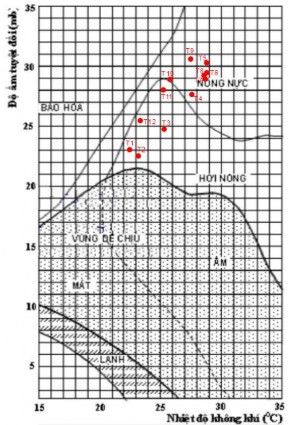
Figure 3.8: Temperature and humidity diagram of Son Hoa station |
see:
Note: T1; T2; T3...: January; February; March...
* Results of analysis of temperature - humidity correlation diagram of Son Hoa station (figure 3.8) show
- Similar to the analysis at Tuy Hoa station, we have the number of days with suitable climate
suitable for human health at Son Hoa station is 150 days (November; December; January; February; March minus 1 day with temperature above 33 o C), the average minimum temperature is 19.0 o C (January), the average minimum temperature is 19.0 o C (January), the average maximum temperature is 19.0 o C (January), the average maximum temperature is 19.0 o C (January), the average minimum ...
84
The average temperature is 32.4 degrees Celsius, with one day having a temperature above 35 degrees Celsius. Compared with the research results on the temperature index suitable for human health by authors: Pham Ngoc Toan - Phan Tat Dac, Indian scientists are suitable [Appendix 3].
- The number of days with climate unsuitable for human health is 215 days (the remaining months, located in the hot zone on the diagram).
The summary of the results of tourism exploitation time assessment is shown in table 3.8.
Table 3.8: Summary of results of tourism exploitation time assessment
TT
TNTN Point Name | Number of days that the activity can be implemented well tourist attraction | Number of days with favorable weather conditions suitable for strength human health | Rating Points | Rating level | |
1 | Vinh Xuan Dai Bay | 275 | 121 | 3 | TB |
2 | Ganh Da Dia | 263 | 121 | 3 | TB |
3 | Hon Yen Complex | 263 | 121 | 3 | TB |
4 | O Loan Lagoon | 263 | 121 | 3 | TB |
5 | Bai Mon - Mui Dai Lanh | 294 | 121 | 3 | TB |
6 | Stone Mountain | 294 | 121 | 3 | TB |
7 | Tu Nham Beach - Bay Peace | 275 | 121 | 3 | TB |
8 | Xep Beach | 263 | 121 | 3 | TB |
9 | Mai Nha Island | 263 | 121 | 3 | TB |
10 | Tuy Hoa City Beach | 263 | 121 | 3 | TB |
11 | Dong Cam Dam | 207 | 150 | 4 | Quite long |
12 | Triem Duc mineral spring | 197 | 150 | 3 | TB |
13 | Van Hoa Plateau | 190 | 150 | 3 | TB |
14 | Ba Ha hydroelectric lake | 190 | 150 | 3 | TB |
15 | Song Hinh Hydroelectric Reservoir | 190 | 150 | 3 | TB |
16 | Ho Xuan Huong | 190 | 150 | 3 | TB |
17 | H'Ly Waterfall | 190 | 150 | 3 | TB |
3.1.2.5. Evaluation of resource accessibility criteria
Table 3.9: Summary of assessment results of accessibility criteria for resource points
TT
TNTN Point Name | Target achieved | Rating Points | Rating level | |
1 | Vinh Xuan Dai Bay | In the North of Tuy Hoa city, 70km from Tuy Hoa city, travel time is about 1 hour 40 minutes along National Highway 1A (asphalt road, good road quality). Means of transport: car, bus, motorbike, taxi. Travel across the bay by fisherman's boat or canoe. | 3 | Favorable medium |
2 | Ganh Da Dia | 36km north of Tuy Hoa city, follow National Highway 1A or Le Duan extended road. Both of these routes have good quality. Good quality, paved or concrete. Means of transport: car, motorbike, taxi or bicycle. Travel time is about 55 minutes. Go down to visit the rapids by stairs, with protective railings. Travel to visit the rapids: on foot. | 5 | Very convenient |
3 | Population Hon Yen | 15km north of Tuy Hoa city, means of transport: car, motorbike, follow the concrete road through Nhon Hoi fishing village or follow the coastal concrete road to Yen village. The road is narrow, densely populated, travel time is about 30 minutes. | 5 | Very convenient |
4 | O Dam Loan | 24km north of Tuy Hoa city. Follow National Highway 1A or Le Duan Street, means of transport are car, motorbike or bicycle. Asphalt road, wide road surface, good road quality, travel time about 35 minutes. | 5 | Very convenient |
5 | Bai Mon - Mui Dai Lanh | 33km south of Tuy Hoa city. Take Phuoc Tan - Bai Nga road (coastal). Asphalt road, wide, good road surface. Means of transport: car, motorbike, bicycle. Travel time to the ticket gate takes about 45 minutes. To get to Mui Dien and base point A8, you can only walk along the concrete road designed with many steps, near the top there is a small trail through the forest canopy, to get to point A8. Travel time is about 1 hour. To get to Bai Mon, must go down the stairs, travel time about 20 minutes. Total travel time about more than 2 hours. | 2 | Less convenient |
6 | Stone Mountain | 30m south of Tuy Hoa city, next to National Highway 1A. Means of transport: car, motorbike, taxi or bicycle along National Highway 1A, asphalt road, no slope, wide road surface, good quality, travel time takes about 35 minutes. To conquer Da Bia peak 706m above sea level, you need to overcome a distance of more than 2.5km with 2000 steps ladder, climbing time is about 2 hours (in good weather conditions). Total travel time takes about 2.5 to 3 hours. | 1 | Very unfavorable |
7 | Tu Beach Nham - Hoa Bay | About 63 km north of Tuy Hoa city. Follow National Highway 1A and inter-village roads. The road is wide, good quality, no steep slopes. Means of transport is car or motorbike. Travel time is about 1 hour 20 minutes. | 4 | Quite convenient |
8 | Xep Beach | 15km north of Tuy Hoa city. Follow National Highway 1A and inter-village road or pass Le Duan. The road is paved, wide, good quality, can use car, motorbike or bicycle. Travel time is about 20 minutes. | 5 | Very convenient profit |
9 | Cu Lao | About 24 km north of Tuy Hoa city. Follow QL1A or Le Duan extended road (to An Hai wharf). | 4 | Rather |
Roof | Asphalt road, wide road surface, good quality, can use car, bus or motorbike. Travel time is about 35 minutes to An Hai wharf. From An Hai wharf, travel to the island by canoe (10 minutes). | favorable | ||
10 | Beach Tuy Hoa City | Located in Tuy Hoa city, right in the city center, so the accessibility is very convenient. The distance from the airport, train station, bus station to the beach is only about 4km, there are many accommodation facilities and tourist services here. | 5 | Very convenient |
11 | Dong Cam Dam | West of Tuy Hoa City. Follow Highway 25 (34km) or go to Phu Lam intersection then follow DT645 route (37km). Road Asphalt, wide road surface, no steep slopes, good quality. Means of transport: car, taxi, motorbike. Travel time is about 50 minutes to 1 hour. Moving within the tourist attractions: walking; moving on the river: small boat. | 5 | Very convenient |
12 | Stream Triem Duc Mineral | 49km northwest of Tuy Hoa city. Follow QL1A through DT 543 to La Hai town, follow Le Loi and Tran Phu streets. Asphalt road, wide surface, good quality, can use car or motorbike. Travel time is about 1 hour 10 minutes. | 4 | Quite convenient |
13 | Van Hoa Plateau | About 34 km north of Tuy Hoa city. Follow QL1A and DT643. The road is paved, wide, good quality, can use cars, buses or motorbikes. Travel time is about 40 minutes. Here, the attractions and accommodations are relatively concentrated and easy to move. The sightseeing route is as follows: City. Tuy Hoa -> Van Hoa lake -> Van Hoa plateau tourist village (7km, via DT643 and 650) -> BB farm (2km, follow 650) -> Go Thi Thung tunnel (5km, follow 650) -> horse racing track (500m, follow 650) -> Long Van lake (with Zen homestay and Long Van Garden 8km, via 650 and DT643) -> A&P Farm (700m, via DT643) -> Uncle Ho church (6km, via DT643) -> red tree garden (10km, follow DT643 and DT648). The traffic routes connecting the attractions are very convenient, asphalt or concrete roads, wide, flat road surface, good road quality, can be traveled by car or motorbike. Calculate the total time to reach It takes about 1 to 2 hours to get to the tourist attractions here. | 4 | Quite convenient |
14 | River hydroelectric reservoir Three lower | About 60 km west of Tuy Hoa city. Take Highway 25 or Highway 29. Asphalt road, wide surface, good quality, the section near the lake has many slopes. You can use car or motorbike. Travel time is about 1 hour 30 minutes. | 3 | Medium advantage jar |
15 | Song hydroelectric lake Image | 70 km southwest of Tuy Hoa city. Take Highway 25 or Highway 29. Asphalt road, wide surface, good quality, the western part of the road is a bit steep. Means of transport by motorbike or car. Travel time is more than 1 hour and 40 minutes. | 3 | Medium advantage jar |
16 | Ho Xuan Smell | 58km west of Tuy Hoa city. Follow Highway 29, asphalt road, wide surface, good quality, from km 30 onwards there are many slopes. Means of transport: car or motorbike. Travel time is about 1 hour 30 minutes. | 4 | Rather favorable |
17 | H'Ly Waterfall | 78 km southwest of Tuy Hoa city, follow National Highway 29 and National Highway 19C. The waterfall is located next to National Highway 19C. The road is paved, wide, good quality, about 20 km in the middle (from Son Thanh to Song Hinh) has many slopes. You can use a car or motorbike. Travel time is about 1 hour 50 minutes. | 3 | Favorable medium |