Tay Ninh is a province in the Southern Key Economic Zone, the most dynamic and developed economic zone in Vietnam. Compared to other provinces in the key zone, Tay Ninh has certain comparative advantages to develop tourism and services.
Firstly, Tay Ninh is only 99 km from Ho Chi Minh City, a market with great demand for rest, entertainment, tourism... On the other hand, its location adjacent to Ho Chi Minh City also creates conditions for Tay Ninh to be able to use existing infrastructure works such as seaports, airports... of Ho Chi Minh City to expand trade and tourism.
Second, Tay Ninh has a great advantage in trading and connecting tourist routes with Cambodia and other ASEAN countries. Tay Ninh has a fairly long national border with many border gates to neighboring countries, of which 2 international border gates are Moc Bai in the south and Xa Mat in the north, which are major sources of international tourists for Tay Ninh. Especially with 2 international border gates, Tay Ninh has two of the most convenient gateways in the region to connect with Cambodia, Thailand and further can connect with India,... Moc Bai border gate is the most convenient border gate to the capital Phnom Penh when it is about 150 km from Phnom Penh, while Xa Mat border gate is the border gate to Angkor relic site - a world cultural heritage recognized by UNESCO - with the shortest distance, only about 300 km. Thus, these two border gates can help tourists travel conveniently by road to the capital Phnom Penh, Angkor relic site, Tonle Sap lake and further to Thailand, India, ... and vice versa.
In the context of current international integration, with its favorable geographical location, Tay Ninh will become one of the important gateways in developing economic, trade and tourism relations between Vietnam and countries in the region as well as other countries through the Trans-Asia road route.
2.1.2. Tourism resources
2.1.2.1. Natural tourism resources
■ Terrain landscape
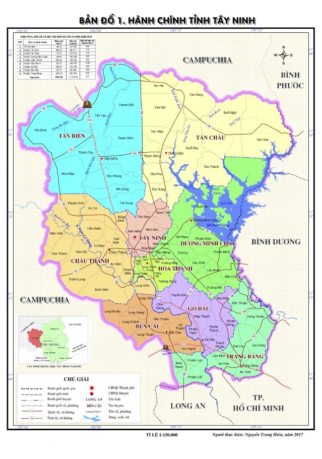
Tay Ninh is located in the transition zone between the South Central Highlands and the Mekong Delta, so it has both the characteristics of a plateau and the appearance of a plain. Although it is a transition zone, the terrain is less complex, relatively flat and has a small slope: the terrain generally decreases from northeast to southwest.
The terrain in Tay Ninh can be divided into four main types: mountains, hills, gently sloping hills and plains [13].
- Mountain terrain : mainly in the Ba Den mountain area. 11km northwest of Tay Ninh city, the Ba Den mountain relic complex covers 24km², consisting of 3 mountains: Heo Mountain (335m) - Phung Mountain (372m) - Ba Den Mountain (986m high, the highest in the South). Ba Den Mountain is a famous historical, cultural and scenic complex of Tay Ninh province with a system of hundreds of caves and pagodas of great natural and humanistic value.
- Hilly terrain : this type of terrain is quite common in Tay Ninh, concentrated in the upper reaches of the Saigon River, along the border of Tay Ninh and Binh Phuoc provinces.
- Gently sloping hill terrain : height varies from 15 - 20m, some places are only 3m above sea level. This type of terrain is found in the south of Tan Bien and appears a lot in the districts: Duong Minh Chau, Hoa Thanh, Trang Bang, Go Dau and a little in Ben Cau.
- Plain terrain : is a type of terrain in alluvial plains forming strips from 20 - 150m wide with a length of only a few kilometers. Distributed along both banks of the Vam Co River, in the districts of Chau Thanh, Hoa Thanh, Ben Cau and Trang Bang.
From the perspective of natural resources and tourism, Tay Ninh, although not rich in terrain types, has the advantage of landscapes associated with mountainous terrain, which is favorable for exploiting tourism activities such as mountain climbing, discovery tourism, eco-tourism, etc.
■ Climate resources
Located in the humid tropics, at low latitudes (10 o 57' to 11 o 47' North), influenced by monsoons, Tay Ninh has a humid tropical monsoon climate, clearly showing equatorial characteristics.
- Radiation regime : total radiation is abundant, averaging 130 - 135 kcal/cm²/year, radiation balance reaches 70 - 75 kcal/cm²/year [13]. High radiation is a favorable factor for economic development, including tourism activities.
- Temperature : Tay Ninh has a high and stable temperature, with an average temperature of 26 - 27 degrees Celsius. Only in the Ba Den mountain area, due to the influence of terrain height, there are months when the temperature drops below 20 degrees Celsius [13]. In general, the average temperature difference
The average temperature between months of the year in Tay Ninh is not large, from 2 - 3 degrees Celsius, while the daily temperature fluctuation amplitude is quite high, in the dry season months it can reach 10 - 12 degrees Celsius.
- Sunshine regime : Abundant light all year round, average annual sunshine hours from 2700 - 2800 hours [13].
- Wind regime : there are 2 prevailing winds in Tay Ninh, which are the Northeast wind and the Southwest monsoon, suitable for the wind regime in the area.
- Rainfall regime : Rainfall is quite large, averaging 1900 - 2300mm, unevenly distributed throughout the year. During the rainy season, there are up to 130 rainy days, accounting for about 85% - 90% of the total annual rainfall [7].
- Humidity : air humidity is relatively high, average 82 - 83%, maximum can reach 86 - 87%. In the rainy season, air humidity is usually 10 - 20% higher than in the dry season [13].
Based on the bio-climatic criteria for human health of Indian scientists (Appendix 3), the suitability of Tay Ninh climate can be assessed as follows:
+ Average annual temperature from 26 - 27 o C → quite suitable (rank 2)
+ Temperature of the hottest month is from 28 - 29 o C → quite suitable (rank 2)
+ Total annual rainfall from 1900 - 2300mm → quite suitable (rank 2)
+ Annual temperature range: 2 - 3 o C → suitable (rank 1)
It can be seen that 4/4 main indicators of Tay Ninh climate are ranked 1 and 2, meaning that it is adaptable and quite adaptable, suitable for human health and can serve tourism well. In general, the climate in Tay Ninh is relatively mild, with abundant radiation, high and stable temperature, favorable for agricultural development and tourism activities.
■ Waterscape
- Surface water resources : The river system in Tay Ninh has a fairly sparse density, only reaching 0.314 km/km 2 [13]. During the year, the river water regime changes significantly with the seasons due to seasonal changes in rainfall distribution. Surface water resources depend mainly on the operating regime of two river systems flowing through, the Saigon River and the Vam Co Dong River.
In the upper reaches of the Saigon River, there is Dau Tieng Lake, the largest irrigation project in the country with an area of 27,000 hectares and a capacity of 1.5 billion m3 [ 13]. Dau Tieng Lake has an influence
directly and indirectly to surface water, groundwater, and the vast ecological environment surrounding the lake. At the same time, this is also one of the important places for fisheries development and has an ecological landscape that attracts tourists.
- Groundwater resources : the groundwater reserves in Tay Ninh are quite abundant, the average depth of the groundwater is from 4 - 11m. The total amount of groundwater that can be exploited is from 50,000 - 100,000m3 / hour [13]. This is a good quality water source, which can serve production, daily life and tourism. In addition, Tay Ninh also has a mineral water source in Ninh Dien (Chau Thanh district) with a reserve of 838m3 / day, this is hot mineral water of grade Silic (B+C1+C2) with mineral content beneficial to human health [13].
It can be seen that the water resources serving the tourism development of Tay Ninh are quite abundant. In addition to exploitation for production and daily life, the water surfaces of rivers and lakes are also exploited for tourism activities, but the exploitation rate is still too low compared to the potential.
■ Biological landscape
Forests in Tay Ninh have many ecological characteristics of tropical forests in the Southeast region with diverse forest vegetation including many species, mostly sparse, low-humidity broadleaf forests, mixed forests of bamboo and timber trees, distributed mainly in the northern districts. According to statistics, by 2016, the total forest area of Tay Ninh was about
66,151 ha, of which natural forest is about 45,118 ha [7].
The most prominent biological landscape of Tay Ninh is Lo Go - Xa Mat National Park located in Tan Bien district, Tay Ninh province, about 30km northwest of Tay Ninh city. Lo Go - Xa Mat has a rich fauna, especially rare water birds. This is also a stopover for red-crowned cranes on their migration route to their breeding grounds in Cambodia. The flora is also quite rich, with many valuable species, some of which are listed in the Red Book such as: go cate, giang huong, mac sua, etc. Lo Go - Xa Mat is one of the places of great significance for tourism development, especially ecotourism.
Tay Ninh's natural resources and tourism resources are the premise for developing tourism activities with diverse types such as sightseeing, research, eco-tourism, resorts, etc.
2.1.2.2. Cultural tourism resources
■ Population and ethnicity
Regarding population: Tay Ninh's population ranks 4th in the Southeast after Ho Chi Minh City, Dong Nai and Binh Duong (in 2016, it was 1,119,839 people, equivalent to 1.25% of the country's population) [7]. The population growth rate has tended to decrease rapidly in recent years. By 2016, the rate was only 0.75%/year.
Table 2.1. Population growth rate of Tay Ninh province in the period 2000 - 2016
Unit:%
Year
2000 | 2005 | 2007 | 2008 | 2010 | 2012 | 2015 | 2016 | |
Population growth rate | 1.6 | 1.25 | 1.14 | 1.04 | 0.86 | 0.87 | 0.73 | 0.75 |
Maybe you are interested!
-
 Current Status of Tourism Development in Tay Ninh Province
 -
 Identify Rating Levels and Rating Scales
zt2i3t4l5ee
zt2a3gstourism,quan lan,quang ninh,ecology,ecotourism,minh chau,van don,geography,geographical basis,tourism development,science
zt2a3ge
zc2o3n4t5e6n7ts
of the islanders. Therefore, this indicator will be divided into two sub-indicators:
a1. Natural tourism attractiveness a2. Cultural tourism attractiveness
b. Tourist capacity
The two island communes in Quan Lan have different capacities to receive tourists. Minh Chau Commune is home to many standard hotels and resorts, attracting high-income domestic and international tourists. Meanwhile, Quan Lan Commune has many motels mainly built and operated by local people, so the scale and quality are not high, and will be suitable for ordinary tourists such as students.
c. Time of exploitation of Quan Lan Island Commune:
Quan Lan tourism is seasonal due to weather and climate conditions and festivals only take place on certain days of the year, specifically in spring. In Quan Lan commune, the period from April to June and from September to November is considered the best time to visit Quan Lan because the cultural tourism activities are mainly associated with festivals taking place during this time.
Minh Chau island commune:
Tourism exploitation time is all year round, because this is a place with a number of tourist attractions with diverse ecosystems such as Bai Tu Long National Park Research Center, Tram forest, Turtle Laying Beach, so besides coming to the beach for tourism and vacation in the summer, Minh Chau will attract research groups to come for tourism combined with research at other times of the year.
d. Sustainability
The sustainability of ecotourism sites in Quan Lan and Minh Chau communes depends on the sensitivity of the ecosystems to climate changes.
landscape. In general, these tourist destinations have a fairly high level of sustainability, because they are natural ecosystems, planned and protected. However, if a large number of tourists gather at certain times, it can exceed the carrying capacity and affect the sustainability of the environment (polluted beaches, damaged trees, animals moving away from their habitats, etc.), then the sustainability of the above ecosystems (natural ecosystems, human ecosystems) will also be affected and become less sustainable.
e. Location and accessibility
Both island communes have ports to take tourists to visit from Van Don wharf:
- Quan Lan – Van Don traffic route:
Phuc Thinh – Viet Anh high-speed boat and Quang Minh high-speed boat, depart at 8am and 2pm from Van Don to Quan Lan, and at 7am and 1pm from Quan Lan to Van Don. There are also wooden boats departing at 7am and 1pm.
- Van Don - Minh Chau traffic route:
Chung Huong high-speed train, Minh Chau train, morning 7:30 and afternoon 13:30 from Van Don to Minh Chau, morning 6:30 and afternoon 13:00 from Minh Chau to Van Don.
f. Infrastructure
Despite receiving investment attention, the issue of infrastructure and technical facilities for tourism on Quan Lan Island is still an issue that needs to be resolved because it has a direct impact on the implementation of ecotourism activities. The minimum conditions for serving tourists such as accommodation, electricity, water, communication, especially medical services, and security work need to be given top priority. Ecotourism spots in Minh Chau commune are assessed to have better infrastructure and technical facilities for tourism because there are quite complete and synchronous conditions for serving tourists, meeting many needs of domestic and foreign tourists.
3.2.1.4. Determine assessment levels and assessment scales
Corresponding to the levels of each criterion, the index is the score of those levels in the order of 4, 3, 2, 1 decreasing according to the standard of each level: very attractive (4), attractive (3), average (2), less attractive (1).
3.2.1.5. Determining the coefficients of the criteria
For the assessment of DLST in the two communes of Quan Lan and Minh Chau islands, the students added evaluation coefficients to show the importance of the criteria and indicators as follows:
Coefficient 3 with criteria: Attractiveness, Exploitation time. These are the 2 most important criteria for attracting tourists to tourism in general and eco-tourism in particular, so they have the highest coefficient.
Coefficient 2 with criteria: Capacity, Infrastructure, Location and accessibility . Because the assessment area is an island commune of Van Don district, the above criteria are selected by the author with appropriate coefficients at the average level.
Coefficient 1 with criteria: Sustainability. Quan Lan has natural and human-made ecotourism sites, with high biodiversity and little impact from local human factors. Most of the ecotourism sites are still wild, so they are highly sustainable.
3.2.1.6. Results of DLST assessment on Quan Lan island
a. Assessment of the potential for natural tourism development
For Minh Chau commune:
+ Natural tourism attractiveness is determined to be very attractive (4 points) and the most important coefficient (coefficient 3), so the score of the Attractiveness criterion is 4 x 3 = 12.
+ Capacity is determined as average (2 points) and the coefficient is quite important (coefficient 2), then the score of Capacity criterion is 2 x 2 = 4.
+ Exploitation time is long (4 points), the most important coefficient (coefficient 3) so the score of the Exploitation time criterion is 4 x 3 = 12.
+ Sustainability is determined as sustainable (4 points), the important coefficient is the average coefficient (coefficient 1), so the score of the Sustainability criterion is 4 x 1 = 4 points
+ Location and accessibility are determined to be quite favorable (2 points), the coefficient is quite important (coefficient 2), the criterion score is 2 x 2 = 4 points.
+ Infrastructure is assessed as good (3 points), the coefficient is quite important (coefficient 2), then the score of the Infrastructure criterion is 3 x 2 = 6 points.
The total score for evaluating DLST in Minh Chau commune according to 6 evaluation criteria is determined as: 12 + 4 + 12 + 4 + 4 + 6 = 42 points
Similar assessment for Quan Lan commune, we have the following table:
Table 3.3: Assessment of the potential for natural ecotourism development in Quan Lan and Minh Chau communes
Attractiveness of self-tourismof course
Capacity
Mining time
Sustainability
Location and accessibility
Infrastructure
Result
Point
DarkMulti
Point
DarkMulti
Point
DarkMulti
Point
DarkMulti
Point
DarkMulti
Point
DarkMulti
CommuneMinh Chau
12
12
4
8
12
12
4
4
4
8
6
8
42/52
Quan CommuneLan
6
12
6
8
9
12
4
4
4
8
4
8
33/52
b. Assessment of the potential for humanistic tourism development
For Quan Lan commune:
+ The attractiveness of human tourism is determined to be very attractive (4 points) and the most important coefficient (coefficient 3), so the score of the Attractiveness criterion is 4 x 3 = 12.
+ Capacity is determined to be large (3 points) and the coefficient is quite important (coefficient 2), then the score of the Capacity criterion is 3 x 2 = 6.
+ Mining time is average (3 points), the most important coefficient (coefficient 3) so the score of the Mining time criterion is 3 x 3 = 9.
+ Sustainability is determined as sustainable (4 points), the important coefficient is the average coefficient (coefficient 1), so the score of the Sustainability criterion is 4 x 1 = 4 points.
+ Location and accessibility are determined to be quite favorable (2 points), the coefficient is quite important (coefficient 2), the criterion score is 2 x 2 = 4 points.
+ Infrastructure is rated as average (2 points), the coefficient is quite important (coefficient 2), then the score of the Infrastructure criterion is 2 x 2 = 4 points.
The total score for evaluating DLST in Quan Lan commune according to 6 evaluation criteria is determined as: 12 + 6 + 6 + 4 + 4 + 4 = 36 points.
Similar assessment with Minh Chau commune we have the following table:
Table 3.4: Assessment of the potential for developing humanistic eco-tourism in Quan Lan and Minh Chau communes
Attractiveness of human tourismliterature
Capacity
Mining time
Sustainability
Location and accessibility
Infrastructure
Result
Point
DarkMulti
Point
DarkMulti
Point
DarkMulti
Point
DarkMulti
Point
DarkMulti
Point
DarkMulti
Quan CommuneLan
12
12
6
8
9
12
4
4
4
8
4
8
39/52
Minh CommuneChau
6
12
4
8
12
12
4
4
4
8
6
8
36/52
Basically, both Minh Chau and Quan Lan localities have quite favorable conditions for developing ecotourism. However, Quan Lan commune has more advantages to develop ecotourism in a humanistic direction, because this is an area with many famous historical relics such as Quan Lan Communal House, Quan Lan Pagoda, Temple worshiping the hero Tran Khanh Du, ... along with local festivals held annually such as the wind praying ceremony (March 15), Quan Lan festival (June 10-19); due to its location near the port and long exploitation time, the beaches in Quan Lan commune (especially Quan Lan beach) are no longer hygienic and clean to ensure the needs of tourists coming to relax and swim; this is also an area with many beautiful landscapes such as Got Beo wind pass, Ong Phong head, Voi Voi cave, but the ability to access these places is still very limited (dirt hill road, lots of gravel and rocks), especially during rainy and windy times; In addition, other natural resources such as mangrove forests and sea worms have not been really exploited for tourism purposes and ecotourism development. On the contrary, Minh Chau commune has more advantages in developing ecotourism in the direction of natural tourism, this is an area with diverse ecosystems such as at Rua De Beach, Bai Tu Long National Park Conservation Center...; Minh Chau beach is highly appreciated for its natural beauty and cleanliness, ranked in the top ten most beautiful beaches in Vietnam; Minh Chau commune is also home to Tram forest with a large area and a purity of up to 90%, suitable for building bridges through the forest (a very effective type of natural ecotourism currently applied by many countries) for tourists to sightsee, as well as for the purpose of studying and researching.
Figure 3.1: Thenmala Forest Bridge (India) Source: https://www.thenmalaecotourism.com/(August 21, 2019)
3.2.2. Using SWOT matrix to evaluate Quan Lan island tourism
General assessment of current tourism activities of Quan Lan island is shown through the following SWOT matrix:
Table 3.5: SWOT matrix evaluating tourism activities on Quan Lan island
Internal agent
Strengths- There is a lot of potential for tourism development, especially natural ecotourism and humanistic ecotourism.- The unskilled labor force is relatively abundant.- resource environmentunpolluted, still
Weaknesses- Poorly developed infrastructure, especially traffic routes to tourist destinations on the island.- The team of professional staff is still weak.- Tourism products in general
quite wild, originalintact
general and DLST in particularalone is monotonous.
External agents
Opportunity- Tourism is a key industry in the socio-economic development strategy of the province and Van Don economic zone.- Quan Lan was selected as a pilot area for eco-tourism development within the framework of the green growth project between Quang Ninh province and the Japanese organization JICA.- The flow of tourists and especially ecotourism in the world tends toincreasing
Challenge- Weather and climate change abnormally.- Competition in tourism products is increasingly fierce, especially with other localities in the province such as Ha Long, Mong Cai...- Awareness of tourists, especially domestic tourists, about ecotourism and nature conservation is not high.
Through summary analysis using SWOT matrix we see that:
To exploit strengths and take advantage of opportunities, it is necessary to:
- Diversify products and service types (build more tourism routes aimed at specific needs of tourists: experiential tourism immersed in nature, spiritual cultural tourism...)
- Effective exploitation of resources and differentiated products (natural resources and human resources)
div.maincontent .p { color: black; font-family:"Times New Roman", serif; font-style: normal; font-weight: normal; text-decoration: none; font-size: 14pt; margin:0pt; } div.maincontent p { color: black; font-family:"Times New Roman", serif; font-style: normal; font-weight: normal; text-decoration: none; font-size: 14pt; margin:0pt; } div.maincontent .s1 { color: black; font-family:"Times New Roman", serif; font-style: normal; font-weight: normal; text-decoration: none; font-size: 13pt; } div.maincontent .s2 { color: black; font-family:"Times New Roman", serif; font-style: normal; font-weight: normal; text-decoration: none; font-size: 13pt; } div.maincontent .s3 { color: #0D0D0D; font-family:"Times New Roman", serif; font-style: normal; font-weight: bold; text-decoration: none; font-size: 14pt; } div.maincontent .s4 { color: black; font-family:"Times New Roman", serif; font-style: italic; font-weight: normal; text-decoration: none; font-size: 14pt; } div.maincontent .s5 { color: black; font-family:"Times New Roman", serif; font-style: italic; font-weight: bold; text-decoration: none; font-size: 14pt; } div.maincontent .s6 { color: black; font-family:"Times New Roman", serif; font-style: italic; font-weight: normal; text-decoration: none; font-size: 14pt; vertical-align: -3pt; } div.maincontent .s7 { color: black; font-family:"Times New Roman", serif; font-style: italic; font-weight: normal; text-decoration: none; font-size: 14pt; vertical-align: -2pt; } div.maincontent .s8 { color: black; font-family:"Times New Roman", serif; font-style: italic; font-weight: normal; text-decoration: none; font-size: 14pt; vertical-align: -1pt; } div.maincontent .s9 { color: black; font-family:"Times New Roman", serif; font-style: normal; font-weight: normal; text-decoration: none; font-size: 14pt; } div.maincontent .s10 { color: black; font-family:"Times New Roman", serif; font-style: normal; font-weight: bold; text-decoration: none; font-size: 14pt; } div.maincontent .s11 { color: black; font-family:"Times New Roman", serif; font-style: normal; font-weight: normal; text-decoration: none; font-size: 14pt; } div.maincontent .s12 { color: black; font-family:Symbol, serif; font-style: normal; font-weight: normal; text-decoration: none; font-size: 14pt; } div.maincontent .s13 { color: black; font-family:Wingdings; font-style: normal; font-weight: normal; text-decoration: none; font-size: 14pt; } div.maincontent .s14 { color: black; font-family:"Times New Roman", serif; font-style: normal; font-weight: normal; text-decoration: none; font-size: 9pt; vertical-align: 5pt; } div.maincontent .s15 { color: black; font-family:"Times New Roman", serif; font-style: normal; font-weight: normal; text-decoration: none; font-size: 9pt; vertical-align: 5pt; } div.maincontent .s16 { color: black; font-family:Cambria, serif; font-style: italic; font-weight: normal; text-decoration: none; font-size: 14pt; } div.maincontent .s17 { color: #080808; font-family:"Times New Roman", serif; font-style: normal; font-weight: bold; text-decoration: none; font-size: 14pt; } div.maincontent .s18 { color: #080808; font-family:"Times New Roman", serif; font-style: normal; font-weight: normal; text-decoration: none; font-size: 14pt; } div.maincontent .s19 { color: black; font-family:"Times New Roman", serif; font-style: normal; font-weight: normal; text-decoration: none; font-size: 11pt; } div.maincontent .s20 { color: black; font-family:"Times New Roman", serif; font-style: normal; font-weight: normal; text-decoration: none; font-size: 10pt; } div.maincontent .s21 { color: black; font-family:"Times New Roman", serif; font-style: normal; font-weight: bold; text-decoration: none; font-size: 11pt; } div.maincontent .s22 { color: black; font-family:"Times New Roman", serif; font-style: normal; font-weight: normal; text-decoration: none; font-size: 11pt; } div.maincontent .s23 { color: black; font-family:"Times New Roman", serif; font-style: italic; font-weight: normal; text-decoration: none; font-size: 14pt; } div.maincontent .s24 { color: #212121; font-family:"Times New Roman", serif; font-style: normal; font-weight: normal; tex
Identify Rating Levels and Rating Scales
zt2i3t4l5ee
zt2a3gstourism,quan lan,quang ninh,ecology,ecotourism,minh chau,van don,geography,geographical basis,tourism development,science
zt2a3ge
zc2o3n4t5e6n7ts
of the islanders. Therefore, this indicator will be divided into two sub-indicators:
a1. Natural tourism attractiveness a2. Cultural tourism attractiveness
b. Tourist capacity
The two island communes in Quan Lan have different capacities to receive tourists. Minh Chau Commune is home to many standard hotels and resorts, attracting high-income domestic and international tourists. Meanwhile, Quan Lan Commune has many motels mainly built and operated by local people, so the scale and quality are not high, and will be suitable for ordinary tourists such as students.
c. Time of exploitation of Quan Lan Island Commune:
Quan Lan tourism is seasonal due to weather and climate conditions and festivals only take place on certain days of the year, specifically in spring. In Quan Lan commune, the period from April to June and from September to November is considered the best time to visit Quan Lan because the cultural tourism activities are mainly associated with festivals taking place during this time.
Minh Chau island commune:
Tourism exploitation time is all year round, because this is a place with a number of tourist attractions with diverse ecosystems such as Bai Tu Long National Park Research Center, Tram forest, Turtle Laying Beach, so besides coming to the beach for tourism and vacation in the summer, Minh Chau will attract research groups to come for tourism combined with research at other times of the year.
d. Sustainability
The sustainability of ecotourism sites in Quan Lan and Minh Chau communes depends on the sensitivity of the ecosystems to climate changes.
landscape. In general, these tourist destinations have a fairly high level of sustainability, because they are natural ecosystems, planned and protected. However, if a large number of tourists gather at certain times, it can exceed the carrying capacity and affect the sustainability of the environment (polluted beaches, damaged trees, animals moving away from their habitats, etc.), then the sustainability of the above ecosystems (natural ecosystems, human ecosystems) will also be affected and become less sustainable.
e. Location and accessibility
Both island communes have ports to take tourists to visit from Van Don wharf:
- Quan Lan – Van Don traffic route:
Phuc Thinh – Viet Anh high-speed boat and Quang Minh high-speed boat, depart at 8am and 2pm from Van Don to Quan Lan, and at 7am and 1pm from Quan Lan to Van Don. There are also wooden boats departing at 7am and 1pm.
- Van Don - Minh Chau traffic route:
Chung Huong high-speed train, Minh Chau train, morning 7:30 and afternoon 13:30 from Van Don to Minh Chau, morning 6:30 and afternoon 13:00 from Minh Chau to Van Don.
f. Infrastructure
Despite receiving investment attention, the issue of infrastructure and technical facilities for tourism on Quan Lan Island is still an issue that needs to be resolved because it has a direct impact on the implementation of ecotourism activities. The minimum conditions for serving tourists such as accommodation, electricity, water, communication, especially medical services, and security work need to be given top priority. Ecotourism spots in Minh Chau commune are assessed to have better infrastructure and technical facilities for tourism because there are quite complete and synchronous conditions for serving tourists, meeting many needs of domestic and foreign tourists.
3.2.1.4. Determine assessment levels and assessment scales
Corresponding to the levels of each criterion, the index is the score of those levels in the order of 4, 3, 2, 1 decreasing according to the standard of each level: very attractive (4), attractive (3), average (2), less attractive (1).
3.2.1.5. Determining the coefficients of the criteria
For the assessment of DLST in the two communes of Quan Lan and Minh Chau islands, the students added evaluation coefficients to show the importance of the criteria and indicators as follows:
Coefficient 3 with criteria: Attractiveness, Exploitation time. These are the 2 most important criteria for attracting tourists to tourism in general and eco-tourism in particular, so they have the highest coefficient.
Coefficient 2 with criteria: Capacity, Infrastructure, Location and accessibility . Because the assessment area is an island commune of Van Don district, the above criteria are selected by the author with appropriate coefficients at the average level.
Coefficient 1 with criteria: Sustainability. Quan Lan has natural and human-made ecotourism sites, with high biodiversity and little impact from local human factors. Most of the ecotourism sites are still wild, so they are highly sustainable.
3.2.1.6. Results of DLST assessment on Quan Lan island
a. Assessment of the potential for natural tourism development
For Minh Chau commune:
+ Natural tourism attractiveness is determined to be very attractive (4 points) and the most important coefficient (coefficient 3), so the score of the Attractiveness criterion is 4 x 3 = 12.
+ Capacity is determined as average (2 points) and the coefficient is quite important (coefficient 2), then the score of Capacity criterion is 2 x 2 = 4.
+ Exploitation time is long (4 points), the most important coefficient (coefficient 3) so the score of the Exploitation time criterion is 4 x 3 = 12.
+ Sustainability is determined as sustainable (4 points), the important coefficient is the average coefficient (coefficient 1), so the score of the Sustainability criterion is 4 x 1 = 4 points
+ Location and accessibility are determined to be quite favorable (2 points), the coefficient is quite important (coefficient 2), the criterion score is 2 x 2 = 4 points.
+ Infrastructure is assessed as good (3 points), the coefficient is quite important (coefficient 2), then the score of the Infrastructure criterion is 3 x 2 = 6 points.
The total score for evaluating DLST in Minh Chau commune according to 6 evaluation criteria is determined as: 12 + 4 + 12 + 4 + 4 + 6 = 42 points
Similar assessment for Quan Lan commune, we have the following table:
Table 3.3: Assessment of the potential for natural ecotourism development in Quan Lan and Minh Chau communes
Attractiveness of self-tourismof course
Capacity
Mining time
Sustainability
Location and accessibility
Infrastructure
Result
Point
DarkMulti
Point
DarkMulti
Point
DarkMulti
Point
DarkMulti
Point
DarkMulti
Point
DarkMulti
CommuneMinh Chau
12
12
4
8
12
12
4
4
4
8
6
8
42/52
Quan CommuneLan
6
12
6
8
9
12
4
4
4
8
4
8
33/52
b. Assessment of the potential for humanistic tourism development
For Quan Lan commune:
+ The attractiveness of human tourism is determined to be very attractive (4 points) and the most important coefficient (coefficient 3), so the score of the Attractiveness criterion is 4 x 3 = 12.
+ Capacity is determined to be large (3 points) and the coefficient is quite important (coefficient 2), then the score of the Capacity criterion is 3 x 2 = 6.
+ Mining time is average (3 points), the most important coefficient (coefficient 3) so the score of the Mining time criterion is 3 x 3 = 9.
+ Sustainability is determined as sustainable (4 points), the important coefficient is the average coefficient (coefficient 1), so the score of the Sustainability criterion is 4 x 1 = 4 points.
+ Location and accessibility are determined to be quite favorable (2 points), the coefficient is quite important (coefficient 2), the criterion score is 2 x 2 = 4 points.
+ Infrastructure is rated as average (2 points), the coefficient is quite important (coefficient 2), then the score of the Infrastructure criterion is 2 x 2 = 4 points.
The total score for evaluating DLST in Quan Lan commune according to 6 evaluation criteria is determined as: 12 + 6 + 6 + 4 + 4 + 4 = 36 points.
Similar assessment with Minh Chau commune we have the following table:
Table 3.4: Assessment of the potential for developing humanistic eco-tourism in Quan Lan and Minh Chau communes
Attractiveness of human tourismliterature
Capacity
Mining time
Sustainability
Location and accessibility
Infrastructure
Result
Point
DarkMulti
Point
DarkMulti
Point
DarkMulti
Point
DarkMulti
Point
DarkMulti
Point
DarkMulti
Quan CommuneLan
12
12
6
8
9
12
4
4
4
8
4
8
39/52
Minh CommuneChau
6
12
4
8
12
12
4
4
4
8
6
8
36/52
Basically, both Minh Chau and Quan Lan localities have quite favorable conditions for developing ecotourism. However, Quan Lan commune has more advantages to develop ecotourism in a humanistic direction, because this is an area with many famous historical relics such as Quan Lan Communal House, Quan Lan Pagoda, Temple worshiping the hero Tran Khanh Du, ... along with local festivals held annually such as the wind praying ceremony (March 15), Quan Lan festival (June 10-19); due to its location near the port and long exploitation time, the beaches in Quan Lan commune (especially Quan Lan beach) are no longer hygienic and clean to ensure the needs of tourists coming to relax and swim; this is also an area with many beautiful landscapes such as Got Beo wind pass, Ong Phong head, Voi Voi cave, but the ability to access these places is still very limited (dirt hill road, lots of gravel and rocks), especially during rainy and windy times; In addition, other natural resources such as mangrove forests and sea worms have not been really exploited for tourism purposes and ecotourism development. On the contrary, Minh Chau commune has more advantages in developing ecotourism in the direction of natural tourism, this is an area with diverse ecosystems such as at Rua De Beach, Bai Tu Long National Park Conservation Center...; Minh Chau beach is highly appreciated for its natural beauty and cleanliness, ranked in the top ten most beautiful beaches in Vietnam; Minh Chau commune is also home to Tram forest with a large area and a purity of up to 90%, suitable for building bridges through the forest (a very effective type of natural ecotourism currently applied by many countries) for tourists to sightsee, as well as for the purpose of studying and researching.
Figure 3.1: Thenmala Forest Bridge (India) Source: https://www.thenmalaecotourism.com/(August 21, 2019)
3.2.2. Using SWOT matrix to evaluate Quan Lan island tourism
General assessment of current tourism activities of Quan Lan island is shown through the following SWOT matrix:
Table 3.5: SWOT matrix evaluating tourism activities on Quan Lan island
Internal agent
Strengths- There is a lot of potential for tourism development, especially natural ecotourism and humanistic ecotourism.- The unskilled labor force is relatively abundant.- resource environmentunpolluted, still
Weaknesses- Poorly developed infrastructure, especially traffic routes to tourist destinations on the island.- The team of professional staff is still weak.- Tourism products in general
quite wild, originalintact
general and DLST in particularalone is monotonous.
External agents
Opportunity- Tourism is a key industry in the socio-economic development strategy of the province and Van Don economic zone.- Quan Lan was selected as a pilot area for eco-tourism development within the framework of the green growth project between Quang Ninh province and the Japanese organization JICA.- The flow of tourists and especially ecotourism in the world tends toincreasing
Challenge- Weather and climate change abnormally.- Competition in tourism products is increasingly fierce, especially with other localities in the province such as Ha Long, Mong Cai...- Awareness of tourists, especially domestic tourists, about ecotourism and nature conservation is not high.
Through summary analysis using SWOT matrix we see that:
To exploit strengths and take advantage of opportunities, it is necessary to:
- Diversify products and service types (build more tourism routes aimed at specific needs of tourists: experiential tourism immersed in nature, spiritual cultural tourism...)
- Effective exploitation of resources and differentiated products (natural resources and human resources)
div.maincontent .p { color: black; font-family:"Times New Roman", serif; font-style: normal; font-weight: normal; text-decoration: none; font-size: 14pt; margin:0pt; } div.maincontent p { color: black; font-family:"Times New Roman", serif; font-style: normal; font-weight: normal; text-decoration: none; font-size: 14pt; margin:0pt; } div.maincontent .s1 { color: black; font-family:"Times New Roman", serif; font-style: normal; font-weight: normal; text-decoration: none; font-size: 13pt; } div.maincontent .s2 { color: black; font-family:"Times New Roman", serif; font-style: normal; font-weight: normal; text-decoration: none; font-size: 13pt; } div.maincontent .s3 { color: #0D0D0D; font-family:"Times New Roman", serif; font-style: normal; font-weight: bold; text-decoration: none; font-size: 14pt; } div.maincontent .s4 { color: black; font-family:"Times New Roman", serif; font-style: italic; font-weight: normal; text-decoration: none; font-size: 14pt; } div.maincontent .s5 { color: black; font-family:"Times New Roman", serif; font-style: italic; font-weight: bold; text-decoration: none; font-size: 14pt; } div.maincontent .s6 { color: black; font-family:"Times New Roman", serif; font-style: italic; font-weight: normal; text-decoration: none; font-size: 14pt; vertical-align: -3pt; } div.maincontent .s7 { color: black; font-family:"Times New Roman", serif; font-style: italic; font-weight: normal; text-decoration: none; font-size: 14pt; vertical-align: -2pt; } div.maincontent .s8 { color: black; font-family:"Times New Roman", serif; font-style: italic; font-weight: normal; text-decoration: none; font-size: 14pt; vertical-align: -1pt; } div.maincontent .s9 { color: black; font-family:"Times New Roman", serif; font-style: normal; font-weight: normal; text-decoration: none; font-size: 14pt; } div.maincontent .s10 { color: black; font-family:"Times New Roman", serif; font-style: normal; font-weight: bold; text-decoration: none; font-size: 14pt; } div.maincontent .s11 { color: black; font-family:"Times New Roman", serif; font-style: normal; font-weight: normal; text-decoration: none; font-size: 14pt; } div.maincontent .s12 { color: black; font-family:Symbol, serif; font-style: normal; font-weight: normal; text-decoration: none; font-size: 14pt; } div.maincontent .s13 { color: black; font-family:Wingdings; font-style: normal; font-weight: normal; text-decoration: none; font-size: 14pt; } div.maincontent .s14 { color: black; font-family:"Times New Roman", serif; font-style: normal; font-weight: normal; text-decoration: none; font-size: 9pt; vertical-align: 5pt; } div.maincontent .s15 { color: black; font-family:"Times New Roman", serif; font-style: normal; font-weight: normal; text-decoration: none; font-size: 9pt; vertical-align: 5pt; } div.maincontent .s16 { color: black; font-family:Cambria, serif; font-style: italic; font-weight: normal; text-decoration: none; font-size: 14pt; } div.maincontent .s17 { color: #080808; font-family:"Times New Roman", serif; font-style: normal; font-weight: bold; text-decoration: none; font-size: 14pt; } div.maincontent .s18 { color: #080808; font-family:"Times New Roman", serif; font-style: normal; font-weight: normal; text-decoration: none; font-size: 14pt; } div.maincontent .s19 { color: black; font-family:"Times New Roman", serif; font-style: normal; font-weight: normal; text-decoration: none; font-size: 11pt; } div.maincontent .s20 { color: black; font-family:"Times New Roman", serif; font-style: normal; font-weight: normal; text-decoration: none; font-size: 10pt; } div.maincontent .s21 { color: black; font-family:"Times New Roman", serif; font-style: normal; font-weight: bold; text-decoration: none; font-size: 11pt; } div.maincontent .s22 { color: black; font-family:"Times New Roman", serif; font-style: normal; font-weight: normal; text-decoration: none; font-size: 11pt; } div.maincontent .s23 { color: black; font-family:"Times New Roman", serif; font-style: italic; font-weight: normal; text-decoration: none; font-size: 14pt; } div.maincontent .s24 { color: #212121; font-family:"Times New Roman", serif; font-style: normal; font-weight: normal; tex -
 Sustainable tourism development in Ha Long Bay, Quang Ninh province - 16
 -
 Viewpoints and Goals of Tourism Development in Ninh Binh Province
 -
 Applying biodiversity resource values to sustainable tourism development at the world natural heritage site of Ha Long Bay, Quang Ninh province - 1
Source: [7]
Regarding population structure by age and gender: Tay Ninh has a fairly balanced gender structure with 49.8% male population and 50.2% female population [7]. Regarding population structure by age, the province has a young structure: under working age (33.82%), working age (58.5%) and over working age (7.68%) [7].
Regarding labor force and labor quality: Tay Ninh has a fairly abundant labor force with 648,818 workers out of a total population of more than 1.1 million people in the province [7]. Most of the workers are industrious, hard-working, and have good ability to absorb science and technology, but their professional qualifications are limited. Currently, Tay Ninh has nearly 80% of the labor force that has not been trained. The number of trained workers with university and college degrees or higher accounts for only over 3% [7], much lower than the national average and the Southeast region. The lack of highly qualified workers poses a challenge for the province's tourism development in the current integration trend.
Regarding population distribution, according to 2016 statistics, the total population of the province is 1,119,839 people. The average population density of the whole province is 277 people/km2 . Tay Ninh's population is mainly distributed in rural areas, the rural population accounts for 77.5% of the total population, the urban population accounts for only 22.5% [7], much lower than the Southeast and the whole country.
Regarding occupational structure , there has been a significant change, but sector I still accounts for a fairly high proportion, while sectors II and III are still quite low.
Table 2.2. Occupational structure of Tay Ninh labor force in the period 2000 - 2016
Unit: %
Year
Career structure | |||
Agriculture, forestry and fishery | Industry, construction | Service | |
2000 | 63.27 | 13.14 | 23.59 |
2005 | 59.5 | 14.5 | 26 |
2010 | 50.5 | 20.5 | 29 |
2016 | 37.04 | 26.06 | 36.9 |
Source: [7]. Regarding ethnic structure, Tay Ninh has many ethnic groups living there (about 22 ethnic groups),
The population is mainly Kinh, Cham, Khmer and Hoa. The Kinh people account for the largest proportion (98.4%) [13], mostly originating from the Central provinces such as Quang Nam, Quang Ngai, Binh Thuan... The Khmer people (accounting for 0.65% of the population) live interspersed with the Kinh people; the Chinese people (accounting for 0.62% of the population) are most concentrated in Tay Ninh city and Go Dau town [13]. The Cham people (accounting for 0.22% of the population) mainly reside in Cham Dong Tac hamlet (Tay Ninh city) and Cham Tao Tac hamlet (Tan Hung commune, Tan Chau district). The remaining ethnic groups such as Tay, Thai, Muong, Nung, Dao, Hmong, Gia-rai, E-de... account for only about 0.11% of the province's population [13]. The diversity of ethnic communities with their own unique cultural features is of great significance to tourism activities in the area.
■ Historical and cultural relics
Tay Ninh has a long history of formation and development, a land with a heroic tradition throughout the process of building and defending the country. With the virtues of diligence, creative labor and skill, the old generation of artisans created unique architectural works that are shown in many communal houses, pagodas, temples... During the two resistance wars against French colonialism and American imperialism, Tay Ninh people also built many revolutionary bases. According to statistics, by 2016, Tay Ninh had 85 historical and cultural relics ranked, of which 24 were ranked by the State as national historical and cultural relics (including 1 special national relic) and 61 historical and cultural relics.
Provincial cultural relics have been classified (Appendix 28). According to the nature of the relics, they can be divided into four main groups:
- Archaeological relic group : includes some typical relics such as Lam Tu ancient relic, ancient temples and towers such as Binh Thanh, Chot Mat...
- Typical ancient architectural relics: mainly communal houses scattered in localities, some typical communal houses include: An Tinh communal house, Gia Loc communal house, Long Thanh communal house, Hiep Ninh communal house, Thai Binh communal house...
- Religious architecture: In Tay Ninh, there are many different religions, but the most prominent is Cao Dai. The number of Cao Dai followers is the largest. In addition, there are Catholicism, Buddhism, Protestantism, Islam, etc. Each religion has its own architectural style, making the places of worship very diverse, the most prominent of which is the Cao Dai Holy See. This is an advantage of Tay Ninh in attracting tourists, especially for religious people.
- Revolutionary historical relics: Tay Ninh is a province rich in revolutionary traditions. During the resistance war against the US to save the country, this place used to be the base of the Central Office for Southern Vietnam, the capital of the Provisional Revolutionary Government. In addition to the relic site of the Central Office for Southern Vietnam, along the northern border of the province there are many other relics, along with a system of primeval forests, creating an ideal place for camping, returning to the source, studying the ecosystem... In addition, in Tay Ninh there are many other revolutionary relics. Revolutionary historical relics have great potential to develop the type of return tourism, which has the effect of honoring the heroic feats of previous generations and educating the younger generation to love their homeland. Some typical historical - cultural relics in Tay Ninh:
- Ba Den Mountain Historical, Cultural and Tourist Site (DTLSVH – DT & DL): located in 4 communes and wards: Thanh Tan, Ninh Son, Ninh Thanh, Phan commune, 11km northeast of Tay Ninh city, 110km from Ho Chi Minh City. The mountain is located in a famous DTLSVH complex with charming scenery and many legends.
Ba Den Mountain not only attracts tourists by its majestic mountain scenery but also by the sacredness of its temples associated with the legendary folk story of the female saint Ly Thi Thien Huong (aka Ba Den), who was once conferred by King Gia Long.