discharge into the reservoir location. The discharge works include: culverts, free spillways, gates... Therefore, it is impossible to set up reservoir operations according to the process in the MIKE model.
11. Normally, to solve the problem of flood discharge management according to the reservoir water level, the water level of downstream control points, and the flow to the reservoir, people often use a separate module designed for the reservoir and use the output results as the upper boundary for the MIKE 11 model. This study has built a program for flood routing through the reservoir to calculate the discharge flow.
2.4.3. MIKE 21 model
The MIKE 21 model is a model in the MIKE program suite developed by the Danish Hydraulic Institute (DHI), a software used to simulate flow, discharge, water quality and transport of sediment and pollutants in estuaries, rivers, lakes, seas and other water bodies [85].
The flow module is solved by the finite element mesh method, based on the numerical solution of the Reynolds-averaged Navier-Stokes equations for incompressible fluids in 2 or 3 dimensions combined with the Boussinesq assumption and the hydrostatic pressure assumption. The module therefore includes the equations: continuity, momentum, temperature, salinity and density and they are closed by a turbulence closure scheme. For the three-dimensional case, the sigma coordinate transformation approximation is used.
The spatial discretization of the fundamental equations is performed using the central finite volume method. The spatial domain is discretized by subdividing the continuous domain into non-overlapping grid cells/elements. The subdivided elements are triangular in shape.
Continuity equation:
 (2.5)
(2.5)
Momentum equations in x and y directions respectively
(2.7) |
Maybe you are interested!
-

 Internal control of revenue and expenditure activities at the National Children's Hospital - 2
 -
 Geographical Location, Natural Features, Population, Economy and Culture
 -
 Internal control of revenue and expenditure activities at the National Children's Hospital - 5
 -
 Current Status of Completing Internal Control System at Vietnam's State-owned Enterprises According to COSO International Standards
 -
 Natural, Economic and Social Characteristics of Hanoi and Organizational Structure of People's Court in Hanoi City
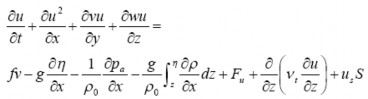
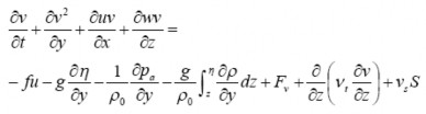
Where t is time; x, y and z are Cartesian coordinates; is water level fluctuation; d is depth; h= +d is total depth; u, v and w are velocity components in x, y and z directions; f=2 sin is Coriolis parameter; g is gravitational acceleration; is water density; t is vertical turbulent viscosity; p a is atmospheric pressure; o is standard density; S is the magnitude of flow due to source points and (u s ,v s ) is the velocity of flow entering the calculation domain. F u , F v are horizontal stress terms.
2.4.4. MIKE FLOOD model
The flow in the flooded area is a horizontal 2-dimensional flow, with both concentrated flow in the river network and surface overflow, so if using a 2-dimensional model to simulate this process, a fairly detailed calculation grid is required to accurately describe the effects of concentrated flow in channels and ditches. On the other hand, surface overflow only occurs when the water level in the river is higher than the bank (or dike) elevation, so to reduce the time and volume of calculations, it is possible to combine the advantages of both 1- and 2-dimensional models by activating the 2-dimensional calculation module when overflow occurs. The MIKE FLOOD model makes connections between the MIKE 11 model (1-dimensional hydraulic calculation of the river network) and the MIKE 21 model (simulating 2-dimensional horizontal shallow water flow) using 4 types of connections [86]:
- Standard connection: used when a one-way river branch flows directly
into two-way flooded area;
- Lateral connection: used when a river branch is adjacent to a flooded area, and when the water level in the river is higher than the bank elevation, it will connect to the corresponding grid cell of the 2D model;
- Building connection (hidden): use various types of connections through the building;
- Dry connection (zero flow link): is a connection that does not allow flow to pass through.
Some comments on the MIKE model : in terms of strengths, it is a commercial model with an easy-to-use interface, and is well compatible with GIS map processing software. This software has been widely used and tested in the world and Vietnam, so it has high reliability. However, there are still some limitations such as: due to the use of the Abbott 6-point difference diagram, it requires thick cross-section data; the reservoir setup is limited, the flood discharge process cannot be calculated through the conditions: inflow to the reservoir, water level of the reservoir, water level at a control point downstream, so it is difficult to operate the reservoir according to the user's wishes. To overcome the calculation of the route through the reservoir for the reservoir system, NCS has built a program to calculate the discharge process at each reservoir. The discharge process is calculated based on the inflow to the reservoir, the scale of the discharge works and the water level at the reservoir.
2.5. Research direction
2.5.1. Research area limits
The research area in the thesis is selected as the downstream of Ca River, including 02 areas: a) The area outside the dike, located inside the river from Linh Cam hydrological station (the confluence of Ngan Pho, Ngan Sau and La rivers) and Nam Dan hydrological station on Ca River to the river mouth (Cua Hoi); b) The area inside the dike includes Vinh city and the surrounding area (Cam River basin). These two areas are separated by the Ta Lam dike system (Figure 2.16). Water from the area inside the dike is drained to the area outside the dike through Ben Thuy and Rao Dung sluices. When the flood in the river is higher than the water in the inland fields, Ben Thuy and Rao Dung sluices will close.
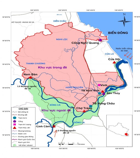
Figure 2.16: Research area limits of the Thesis
2.5.2. Natural characteristics, flood control and drainage dyke systems in the study area

Natural features of the study area
The terrain of the study area tends to be lower towards the East (East Sea). The West is a hilly and low mountain area belonging to Nam Dan and Nghi Loc districts, with an altitude of 190 - 330 m. The remaining area is a low-lying area including: urban areas, residential areas, and rice fields. In particular, the area inside the dike has a very low terrain, concentrated
mainly in Hung Nguyen district, with elevation ranging from 0.2 - 0.5 m. Therefore, the areas along the Ca River and low-lying areas in the dike area are often threatened by flooding.
River network in the study area: In the area outside the dike, there are two main river sections: the main stream of the Ca River from Nam Dan to the estuary, with a length of 38.0 km; and the La River from Linh Cam to the Cho Trang junction, with a length of 12.1 km. The characteristics of these river sections are large width and depth. The level of flooding in this area depends on the flood from upstream and the impact of the tide at the outlet. In the area inside the dike, the river and stream system is very complex, forming a fairly dense network.

Flood control dyke system in the study area
In the study area, there are 2 flood control dyke systems: (1) Lam left/right dyke system and inner city to protect Vinh city (Presented in Section 2.3.3.2 ). Lam left/right dyke system are 2 level III dykes capable of withstanding the historic flood of 1978. Vinh city inner city dyke system is built on both sides of Cua Tien river. This dyke system combined with the North-South railway has the task of preventing floods from Nam Dan, not overflowing into Vinh city and low-lying areas in Hung Nguyen district.

Drainage system in the study area
Water in the area outside the dike is drained to the sea through Cua Hoi. Meanwhile, the area inside the dike is drained to the sea through Nghi Quang sluice and to Ca river through Ben Thuy and Rao Dung sluices. In addition to the main river drainage system presented in Section 2.5.2.1, the study area also has a very complex drainage network of Vinh city and a system of drainage pumping stations. The area inside the dike has 3 drainage pumping stations: Hung Chau, Nam Vinh and Ben Thuy, of which Ben Thuy pumping station has not been in operation for a long time. Nam Vinh drainage pumping station with a total capacity of 57,000 m3/h, is responsible for draining water for low-lying areas in the ward.
Vinh Tan, Truong Thi to Cua Tien River. When the water level in the drainage area is higher than the water level of Cua Tien River, the water flows by itself and vice versa when it cannot flow by itself, Nam Vinh pumping station will operate. Hung Chau drainage pumping station with a total capacity of 64,000 m3/h, is responsible for draining water for low-lying areas in Hung Nguyen district. When the water level in the field exceeds the elevation of 1.5 m, Hung Chau pumping station will operate to drain water for low-lying areas with an area of F = 2,000 ha.
2.5.3. Research content
To assess the impact of factors causing flooding in the downstream area of Ca River, the author will delve into studying 4 main factors: Impact of upstream floods in natural conditions/with the influence of reservoirs; Impact of the reservoir system; Impact of sea level rise due to storms; and impact of heavy rain in the fields.
2.5.3.1. Assessing the role of upstream floods on downstream flooding of the Ca River
The flood process in the downstream of a river basin is the result of the rainfall process in the basin. Rainfall in the basin is a complex process, changing over space and time. In addition, terrain, geological conditions and buffer surface also have significant effects. With this issue, the author will quantify the amount of rainfall causing flooding in the downstream of Ca River at flood levels in 3 stages: early flood season, mid flood season and late flood season.
2.5.3.2. Assessment of the role of the reservoir system in flooding downstream of the Ca River
When building a reservoir system, the flow in the natural river will no longer follow the natural law. The flow will be increased or decreased depending on the discharge or storage of the reservoir. With this issue, the thesis will determine the increase/decrease in flooding downstream of the Ca River when the reservoir discharges/cuts flood and the current downstream situation is at flood levels.
2.5.3.3. Assessing the role of storm surge on flooding downstream of Ca River
The impact of storm surge makes it difficult for downstream floods to drain into the sea, increasing flooding. With this issue, the study will determine the level of increased flooding outside the dike and inundation inside the dike when there is the impact of storm surge and the current downstream situation is at flood levels.
2.5.3.4. Assessing the role of inland rain on flooding downstream of Ca River
The area inside the dike is protected by the Ta Lam dike system, so it is not affected by flooding caused by floods from upstream. The flooding of this area is determined by the following factors: inland rain, drainage through Ben Thuy, Rao Dung, Nghi Quang sluices, and drainage pumping stations. These sluices are all affected by tides. In particular, Ben Thuy and Rao Dung sluices are also affected by floods from the Ca River. In addition, flooding here also depends on the Southern and Hung Chau drainage pumping stations. In this section, the thesis will evaluate the impact of inland rain (in terms of rainfall quantity and intensity), floods on the Ca River, and storm surges causing flooding in the area inside the dike.
2.6. Conclusion of chapter 2
Chapter 2 analyzed 3 factors affecting flooding including endogenous, exogenous and anthropogenic factors. Endogenous factors change very little over time. In which, geographical location, topography and geology change the least over time. Endogenous factors play a very important role in flooding, however, because they change very little over time, they are not included in the quantitative assessment in this study. Exogenous factors are flood-causing factors of hydrometeorological origin that change greatly over space and time. Due to the impact of terrain, the Ca River basin is divided into 5 different rain and flood regions. In which, the upstream rain and flood factor is the most important. The phase difference between rain and flood regions has created the diversity of flooding in the downstream of the Ca River. In fact, the middle and downstream regions have the greatest impact on the level of flooding in the study area. In
Exogenous factors, sea level rise due to storms is also an important factor affecting flooding in the downstream of Ca River, so it should also be carefully studied.
Under the impact of socio-economic development (human factors), the influence of the reservoir system in the upper river plays a very important role. The study has included 13 large reservoirs, especially 3 large reservoirs with flood control tasks in the Inter-reservoir Operation Process, into the calculation, quantitatively assessing its impact on flooding in the downstream.
Due to the synchronization of data and lack of spatial documents, the MIKE model set was chosen as the tool to solve the flooding problem in the downstream of Ca River.