1.2.5. Concept of Ha Tinh region and coastal area
1.2.5.1. Regional concept
Region is a term that has been discussed quite a lot in our country as well as in some countries in the world, especially in the late 19th and early 20th centuries. However, this discussion has not yet led to a unified concept, so the understanding and application of the term "region" in practice in our country is still very different.
In state documents, "region" is used to refer to a certain geographical space that is remote, separated by distance from the political - economic - cultural center, such as "remote area", "remote area", etc. "Region" is sometimes used to refer to a territorial space, including many provinces that have common characteristics or certain characteristics, such as: Northern region, Northwest region, North Central region, etc. This usage has been carried out in the history of zoning in our country mainly to serve management purposes.
Maybe you are interested!
-
 Natural Environment: Each country has a different geographical location, which leads to natural differences such as climate, terrain, resources; needs
 -
 Identify Rating Levels and Rating Scales
zt2i3t4l5ee
zt2a3gstourism,quan lan,quang ninh,ecology,ecotourism,minh chau,van don,geography,geographical basis,tourism development,science
zt2a3ge
zc2o3n4t5e6n7ts
of the islanders. Therefore, this indicator will be divided into two sub-indicators:
a1. Natural tourism attractiveness a2. Cultural tourism attractiveness
b. Tourist capacity
The two island communes in Quan Lan have different capacities to receive tourists. Minh Chau Commune is home to many standard hotels and resorts, attracting high-income domestic and international tourists. Meanwhile, Quan Lan Commune has many motels mainly built and operated by local people, so the scale and quality are not high, and will be suitable for ordinary tourists such as students.
c. Time of exploitation of Quan Lan Island Commune:
Quan Lan tourism is seasonal due to weather and climate conditions and festivals only take place on certain days of the year, specifically in spring. In Quan Lan commune, the period from April to June and from September to November is considered the best time to visit Quan Lan because the cultural tourism activities are mainly associated with festivals taking place during this time.
Minh Chau island commune:
Tourism exploitation time is all year round, because this is a place with a number of tourist attractions with diverse ecosystems such as Bai Tu Long National Park Research Center, Tram forest, Turtle Laying Beach, so besides coming to the beach for tourism and vacation in the summer, Minh Chau will attract research groups to come for tourism combined with research at other times of the year.
d. Sustainability
The sustainability of ecotourism sites in Quan Lan and Minh Chau communes depends on the sensitivity of the ecosystems to climate changes.
landscape. In general, these tourist destinations have a fairly high level of sustainability, because they are natural ecosystems, planned and protected. However, if a large number of tourists gather at certain times, it can exceed the carrying capacity and affect the sustainability of the environment (polluted beaches, damaged trees, animals moving away from their habitats, etc.), then the sustainability of the above ecosystems (natural ecosystems, human ecosystems) will also be affected and become less sustainable.
e. Location and accessibility
Both island communes have ports to take tourists to visit from Van Don wharf:
- Quan Lan – Van Don traffic route:
Phuc Thinh – Viet Anh high-speed boat and Quang Minh high-speed boat, depart at 8am and 2pm from Van Don to Quan Lan, and at 7am and 1pm from Quan Lan to Van Don. There are also wooden boats departing at 7am and 1pm.
- Van Don - Minh Chau traffic route:
Chung Huong high-speed train, Minh Chau train, morning 7:30 and afternoon 13:30 from Van Don to Minh Chau, morning 6:30 and afternoon 13:00 from Minh Chau to Van Don.
f. Infrastructure
Despite receiving investment attention, the issue of infrastructure and technical facilities for tourism on Quan Lan Island is still an issue that needs to be resolved because it has a direct impact on the implementation of ecotourism activities. The minimum conditions for serving tourists such as accommodation, electricity, water, communication, especially medical services, and security work need to be given top priority. Ecotourism spots in Minh Chau commune are assessed to have better infrastructure and technical facilities for tourism because there are quite complete and synchronous conditions for serving tourists, meeting many needs of domestic and foreign tourists.
3.2.1.4. Determine assessment levels and assessment scales
Corresponding to the levels of each criterion, the index is the score of those levels in the order of 4, 3, 2, 1 decreasing according to the standard of each level: very attractive (4), attractive (3), average (2), less attractive (1).
3.2.1.5. Determining the coefficients of the criteria
For the assessment of DLST in the two communes of Quan Lan and Minh Chau islands, the students added evaluation coefficients to show the importance of the criteria and indicators as follows:
Coefficient 3 with criteria: Attractiveness, Exploitation time. These are the 2 most important criteria for attracting tourists to tourism in general and eco-tourism in particular, so they have the highest coefficient.
Coefficient 2 with criteria: Capacity, Infrastructure, Location and accessibility . Because the assessment area is an island commune of Van Don district, the above criteria are selected by the author with appropriate coefficients at the average level.
Coefficient 1 with criteria: Sustainability. Quan Lan has natural and human-made ecotourism sites, with high biodiversity and little impact from local human factors. Most of the ecotourism sites are still wild, so they are highly sustainable.
3.2.1.6. Results of DLST assessment on Quan Lan island
a. Assessment of the potential for natural tourism development
For Minh Chau commune:
+ Natural tourism attractiveness is determined to be very attractive (4 points) and the most important coefficient (coefficient 3), so the score of the Attractiveness criterion is 4 x 3 = 12.
+ Capacity is determined as average (2 points) and the coefficient is quite important (coefficient 2), then the score of Capacity criterion is 2 x 2 = 4.
+ Exploitation time is long (4 points), the most important coefficient (coefficient 3) so the score of the Exploitation time criterion is 4 x 3 = 12.
+ Sustainability is determined as sustainable (4 points), the important coefficient is the average coefficient (coefficient 1), so the score of the Sustainability criterion is 4 x 1 = 4 points
+ Location and accessibility are determined to be quite favorable (2 points), the coefficient is quite important (coefficient 2), the criterion score is 2 x 2 = 4 points.
+ Infrastructure is assessed as good (3 points), the coefficient is quite important (coefficient 2), then the score of the Infrastructure criterion is 3 x 2 = 6 points.
The total score for evaluating DLST in Minh Chau commune according to 6 evaluation criteria is determined as: 12 + 4 + 12 + 4 + 4 + 6 = 42 points
Similar assessment for Quan Lan commune, we have the following table:
Table 3.3: Assessment of the potential for natural ecotourism development in Quan Lan and Minh Chau communes
Attractiveness of self-tourismof course
Capacity
Mining time
Sustainability
Location and accessibility
Infrastructure
Result
Point
DarkMulti
Point
DarkMulti
Point
DarkMulti
Point
DarkMulti
Point
DarkMulti
Point
DarkMulti
CommuneMinh Chau
12
12
4
8
12
12
4
4
4
8
6
8
42/52
Quan CommuneLan
6
12
6
8
9
12
4
4
4
8
4
8
33/52
b. Assessment of the potential for humanistic tourism development
For Quan Lan commune:
+ The attractiveness of human tourism is determined to be very attractive (4 points) and the most important coefficient (coefficient 3), so the score of the Attractiveness criterion is 4 x 3 = 12.
+ Capacity is determined to be large (3 points) and the coefficient is quite important (coefficient 2), then the score of the Capacity criterion is 3 x 2 = 6.
+ Mining time is average (3 points), the most important coefficient (coefficient 3) so the score of the Mining time criterion is 3 x 3 = 9.
+ Sustainability is determined as sustainable (4 points), the important coefficient is the average coefficient (coefficient 1), so the score of the Sustainability criterion is 4 x 1 = 4 points.
+ Location and accessibility are determined to be quite favorable (2 points), the coefficient is quite important (coefficient 2), the criterion score is 2 x 2 = 4 points.
+ Infrastructure is rated as average (2 points), the coefficient is quite important (coefficient 2), then the score of the Infrastructure criterion is 2 x 2 = 4 points.
The total score for evaluating DLST in Quan Lan commune according to 6 evaluation criteria is determined as: 12 + 6 + 6 + 4 + 4 + 4 = 36 points.
Similar assessment with Minh Chau commune we have the following table:
Table 3.4: Assessment of the potential for developing humanistic eco-tourism in Quan Lan and Minh Chau communes
Attractiveness of human tourismliterature
Capacity
Mining time
Sustainability
Location and accessibility
Infrastructure
Result
Point
DarkMulti
Point
DarkMulti
Point
DarkMulti
Point
DarkMulti
Point
DarkMulti
Point
DarkMulti
Quan CommuneLan
12
12
6
8
9
12
4
4
4
8
4
8
39/52
Minh CommuneChau
6
12
4
8
12
12
4
4
4
8
6
8
36/52
Basically, both Minh Chau and Quan Lan localities have quite favorable conditions for developing ecotourism. However, Quan Lan commune has more advantages to develop ecotourism in a humanistic direction, because this is an area with many famous historical relics such as Quan Lan Communal House, Quan Lan Pagoda, Temple worshiping the hero Tran Khanh Du, ... along with local festivals held annually such as the wind praying ceremony (March 15), Quan Lan festival (June 10-19); due to its location near the port and long exploitation time, the beaches in Quan Lan commune (especially Quan Lan beach) are no longer hygienic and clean to ensure the needs of tourists coming to relax and swim; this is also an area with many beautiful landscapes such as Got Beo wind pass, Ong Phong head, Voi Voi cave, but the ability to access these places is still very limited (dirt hill road, lots of gravel and rocks), especially during rainy and windy times; In addition, other natural resources such as mangrove forests and sea worms have not been really exploited for tourism purposes and ecotourism development. On the contrary, Minh Chau commune has more advantages in developing ecotourism in the direction of natural tourism, this is an area with diverse ecosystems such as at Rua De Beach, Bai Tu Long National Park Conservation Center...; Minh Chau beach is highly appreciated for its natural beauty and cleanliness, ranked in the top ten most beautiful beaches in Vietnam; Minh Chau commune is also home to Tram forest with a large area and a purity of up to 90%, suitable for building bridges through the forest (a very effective type of natural ecotourism currently applied by many countries) for tourists to sightsee, as well as for the purpose of studying and researching.
Figure 3.1: Thenmala Forest Bridge (India) Source: https://www.thenmalaecotourism.com/(August 21, 2019)
3.2.2. Using SWOT matrix to evaluate Quan Lan island tourism
General assessment of current tourism activities of Quan Lan island is shown through the following SWOT matrix:
Table 3.5: SWOT matrix evaluating tourism activities on Quan Lan island
Internal agent
Strengths- There is a lot of potential for tourism development, especially natural ecotourism and humanistic ecotourism.- The unskilled labor force is relatively abundant.- resource environmentunpolluted, still
Weaknesses- Poorly developed infrastructure, especially traffic routes to tourist destinations on the island.- The team of professional staff is still weak.- Tourism products in general
quite wild, originalintact
general and DLST in particularalone is monotonous.
External agents
Opportunity- Tourism is a key industry in the socio-economic development strategy of the province and Van Don economic zone.- Quan Lan was selected as a pilot area for eco-tourism development within the framework of the green growth project between Quang Ninh province and the Japanese organization JICA.- The flow of tourists and especially ecotourism in the world tends toincreasing
Challenge- Weather and climate change abnormally.- Competition in tourism products is increasingly fierce, especially with other localities in the province such as Ha Long, Mong Cai...- Awareness of tourists, especially domestic tourists, about ecotourism and nature conservation is not high.
Through summary analysis using SWOT matrix we see that:
To exploit strengths and take advantage of opportunities, it is necessary to:
- Diversify products and service types (build more tourism routes aimed at specific needs of tourists: experiential tourism immersed in nature, spiritual cultural tourism...)
- Effective exploitation of resources and differentiated products (natural resources and human resources)
div.maincontent .p { color: black; font-family:"Times New Roman", serif; font-style: normal; font-weight: normal; text-decoration: none; font-size: 14pt; margin:0pt; } div.maincontent p { color: black; font-family:"Times New Roman", serif; font-style: normal; font-weight: normal; text-decoration: none; font-size: 14pt; margin:0pt; } div.maincontent .s1 { color: black; font-family:"Times New Roman", serif; font-style: normal; font-weight: normal; text-decoration: none; font-size: 13pt; } div.maincontent .s2 { color: black; font-family:"Times New Roman", serif; font-style: normal; font-weight: normal; text-decoration: none; font-size: 13pt; } div.maincontent .s3 { color: #0D0D0D; font-family:"Times New Roman", serif; font-style: normal; font-weight: bold; text-decoration: none; font-size: 14pt; } div.maincontent .s4 { color: black; font-family:"Times New Roman", serif; font-style: italic; font-weight: normal; text-decoration: none; font-size: 14pt; } div.maincontent .s5 { color: black; font-family:"Times New Roman", serif; font-style: italic; font-weight: bold; text-decoration: none; font-size: 14pt; } div.maincontent .s6 { color: black; font-family:"Times New Roman", serif; font-style: italic; font-weight: normal; text-decoration: none; font-size: 14pt; vertical-align: -3pt; } div.maincontent .s7 { color: black; font-family:"Times New Roman", serif; font-style: italic; font-weight: normal; text-decoration: none; font-size: 14pt; vertical-align: -2pt; } div.maincontent .s8 { color: black; font-family:"Times New Roman", serif; font-style: italic; font-weight: normal; text-decoration: none; font-size: 14pt; vertical-align: -1pt; } div.maincontent .s9 { color: black; font-family:"Times New Roman", serif; font-style: normal; font-weight: normal; text-decoration: none; font-size: 14pt; } div.maincontent .s10 { color: black; font-family:"Times New Roman", serif; font-style: normal; font-weight: bold; text-decoration: none; font-size: 14pt; } div.maincontent .s11 { color: black; font-family:"Times New Roman", serif; font-style: normal; font-weight: normal; text-decoration: none; font-size: 14pt; } div.maincontent .s12 { color: black; font-family:Symbol, serif; font-style: normal; font-weight: normal; text-decoration: none; font-size: 14pt; } div.maincontent .s13 { color: black; font-family:Wingdings; font-style: normal; font-weight: normal; text-decoration: none; font-size: 14pt; } div.maincontent .s14 { color: black; font-family:"Times New Roman", serif; font-style: normal; font-weight: normal; text-decoration: none; font-size: 9pt; vertical-align: 5pt; } div.maincontent .s15 { color: black; font-family:"Times New Roman", serif; font-style: normal; font-weight: normal; text-decoration: none; font-size: 9pt; vertical-align: 5pt; } div.maincontent .s16 { color: black; font-family:Cambria, serif; font-style: italic; font-weight: normal; text-decoration: none; font-size: 14pt; } div.maincontent .s17 { color: #080808; font-family:"Times New Roman", serif; font-style: normal; font-weight: bold; text-decoration: none; font-size: 14pt; } div.maincontent .s18 { color: #080808; font-family:"Times New Roman", serif; font-style: normal; font-weight: normal; text-decoration: none; font-size: 14pt; } div.maincontent .s19 { color: black; font-family:"Times New Roman", serif; font-style: normal; font-weight: normal; text-decoration: none; font-size: 11pt; } div.maincontent .s20 { color: black; font-family:"Times New Roman", serif; font-style: normal; font-weight: normal; text-decoration: none; font-size: 10pt; } div.maincontent .s21 { color: black; font-family:"Times New Roman", serif; font-style: normal; font-weight: bold; text-decoration: none; font-size: 11pt; } div.maincontent .s22 { color: black; font-family:"Times New Roman", serif; font-style: normal; font-weight: normal; text-decoration: none; font-size: 11pt; } div.maincontent .s23 { color: black; font-family:"Times New Roman", serif; font-style: italic; font-weight: normal; text-decoration: none; font-size: 14pt; } div.maincontent .s24 { color: #212121; font-family:"Times New Roman", serif; font-style: normal; font-weight: normal; tex
Identify Rating Levels and Rating Scales
zt2i3t4l5ee
zt2a3gstourism,quan lan,quang ninh,ecology,ecotourism,minh chau,van don,geography,geographical basis,tourism development,science
zt2a3ge
zc2o3n4t5e6n7ts
of the islanders. Therefore, this indicator will be divided into two sub-indicators:
a1. Natural tourism attractiveness a2. Cultural tourism attractiveness
b. Tourist capacity
The two island communes in Quan Lan have different capacities to receive tourists. Minh Chau Commune is home to many standard hotels and resorts, attracting high-income domestic and international tourists. Meanwhile, Quan Lan Commune has many motels mainly built and operated by local people, so the scale and quality are not high, and will be suitable for ordinary tourists such as students.
c. Time of exploitation of Quan Lan Island Commune:
Quan Lan tourism is seasonal due to weather and climate conditions and festivals only take place on certain days of the year, specifically in spring. In Quan Lan commune, the period from April to June and from September to November is considered the best time to visit Quan Lan because the cultural tourism activities are mainly associated with festivals taking place during this time.
Minh Chau island commune:
Tourism exploitation time is all year round, because this is a place with a number of tourist attractions with diverse ecosystems such as Bai Tu Long National Park Research Center, Tram forest, Turtle Laying Beach, so besides coming to the beach for tourism and vacation in the summer, Minh Chau will attract research groups to come for tourism combined with research at other times of the year.
d. Sustainability
The sustainability of ecotourism sites in Quan Lan and Minh Chau communes depends on the sensitivity of the ecosystems to climate changes.
landscape. In general, these tourist destinations have a fairly high level of sustainability, because they are natural ecosystems, planned and protected. However, if a large number of tourists gather at certain times, it can exceed the carrying capacity and affect the sustainability of the environment (polluted beaches, damaged trees, animals moving away from their habitats, etc.), then the sustainability of the above ecosystems (natural ecosystems, human ecosystems) will also be affected and become less sustainable.
e. Location and accessibility
Both island communes have ports to take tourists to visit from Van Don wharf:
- Quan Lan – Van Don traffic route:
Phuc Thinh – Viet Anh high-speed boat and Quang Minh high-speed boat, depart at 8am and 2pm from Van Don to Quan Lan, and at 7am and 1pm from Quan Lan to Van Don. There are also wooden boats departing at 7am and 1pm.
- Van Don - Minh Chau traffic route:
Chung Huong high-speed train, Minh Chau train, morning 7:30 and afternoon 13:30 from Van Don to Minh Chau, morning 6:30 and afternoon 13:00 from Minh Chau to Van Don.
f. Infrastructure
Despite receiving investment attention, the issue of infrastructure and technical facilities for tourism on Quan Lan Island is still an issue that needs to be resolved because it has a direct impact on the implementation of ecotourism activities. The minimum conditions for serving tourists such as accommodation, electricity, water, communication, especially medical services, and security work need to be given top priority. Ecotourism spots in Minh Chau commune are assessed to have better infrastructure and technical facilities for tourism because there are quite complete and synchronous conditions for serving tourists, meeting many needs of domestic and foreign tourists.
3.2.1.4. Determine assessment levels and assessment scales
Corresponding to the levels of each criterion, the index is the score of those levels in the order of 4, 3, 2, 1 decreasing according to the standard of each level: very attractive (4), attractive (3), average (2), less attractive (1).
3.2.1.5. Determining the coefficients of the criteria
For the assessment of DLST in the two communes of Quan Lan and Minh Chau islands, the students added evaluation coefficients to show the importance of the criteria and indicators as follows:
Coefficient 3 with criteria: Attractiveness, Exploitation time. These are the 2 most important criteria for attracting tourists to tourism in general and eco-tourism in particular, so they have the highest coefficient.
Coefficient 2 with criteria: Capacity, Infrastructure, Location and accessibility . Because the assessment area is an island commune of Van Don district, the above criteria are selected by the author with appropriate coefficients at the average level.
Coefficient 1 with criteria: Sustainability. Quan Lan has natural and human-made ecotourism sites, with high biodiversity and little impact from local human factors. Most of the ecotourism sites are still wild, so they are highly sustainable.
3.2.1.6. Results of DLST assessment on Quan Lan island
a. Assessment of the potential for natural tourism development
For Minh Chau commune:
+ Natural tourism attractiveness is determined to be very attractive (4 points) and the most important coefficient (coefficient 3), so the score of the Attractiveness criterion is 4 x 3 = 12.
+ Capacity is determined as average (2 points) and the coefficient is quite important (coefficient 2), then the score of Capacity criterion is 2 x 2 = 4.
+ Exploitation time is long (4 points), the most important coefficient (coefficient 3) so the score of the Exploitation time criterion is 4 x 3 = 12.
+ Sustainability is determined as sustainable (4 points), the important coefficient is the average coefficient (coefficient 1), so the score of the Sustainability criterion is 4 x 1 = 4 points
+ Location and accessibility are determined to be quite favorable (2 points), the coefficient is quite important (coefficient 2), the criterion score is 2 x 2 = 4 points.
+ Infrastructure is assessed as good (3 points), the coefficient is quite important (coefficient 2), then the score of the Infrastructure criterion is 3 x 2 = 6 points.
The total score for evaluating DLST in Minh Chau commune according to 6 evaluation criteria is determined as: 12 + 4 + 12 + 4 + 4 + 6 = 42 points
Similar assessment for Quan Lan commune, we have the following table:
Table 3.3: Assessment of the potential for natural ecotourism development in Quan Lan and Minh Chau communes
Attractiveness of self-tourismof course
Capacity
Mining time
Sustainability
Location and accessibility
Infrastructure
Result
Point
DarkMulti
Point
DarkMulti
Point
DarkMulti
Point
DarkMulti
Point
DarkMulti
Point
DarkMulti
CommuneMinh Chau
12
12
4
8
12
12
4
4
4
8
6
8
42/52
Quan CommuneLan
6
12
6
8
9
12
4
4
4
8
4
8
33/52
b. Assessment of the potential for humanistic tourism development
For Quan Lan commune:
+ The attractiveness of human tourism is determined to be very attractive (4 points) and the most important coefficient (coefficient 3), so the score of the Attractiveness criterion is 4 x 3 = 12.
+ Capacity is determined to be large (3 points) and the coefficient is quite important (coefficient 2), then the score of the Capacity criterion is 3 x 2 = 6.
+ Mining time is average (3 points), the most important coefficient (coefficient 3) so the score of the Mining time criterion is 3 x 3 = 9.
+ Sustainability is determined as sustainable (4 points), the important coefficient is the average coefficient (coefficient 1), so the score of the Sustainability criterion is 4 x 1 = 4 points.
+ Location and accessibility are determined to be quite favorable (2 points), the coefficient is quite important (coefficient 2), the criterion score is 2 x 2 = 4 points.
+ Infrastructure is rated as average (2 points), the coefficient is quite important (coefficient 2), then the score of the Infrastructure criterion is 2 x 2 = 4 points.
The total score for evaluating DLST in Quan Lan commune according to 6 evaluation criteria is determined as: 12 + 6 + 6 + 4 + 4 + 4 = 36 points.
Similar assessment with Minh Chau commune we have the following table:
Table 3.4: Assessment of the potential for developing humanistic eco-tourism in Quan Lan and Minh Chau communes
Attractiveness of human tourismliterature
Capacity
Mining time
Sustainability
Location and accessibility
Infrastructure
Result
Point
DarkMulti
Point
DarkMulti
Point
DarkMulti
Point
DarkMulti
Point
DarkMulti
Point
DarkMulti
Quan CommuneLan
12
12
6
8
9
12
4
4
4
8
4
8
39/52
Minh CommuneChau
6
12
4
8
12
12
4
4
4
8
6
8
36/52
Basically, both Minh Chau and Quan Lan localities have quite favorable conditions for developing ecotourism. However, Quan Lan commune has more advantages to develop ecotourism in a humanistic direction, because this is an area with many famous historical relics such as Quan Lan Communal House, Quan Lan Pagoda, Temple worshiping the hero Tran Khanh Du, ... along with local festivals held annually such as the wind praying ceremony (March 15), Quan Lan festival (June 10-19); due to its location near the port and long exploitation time, the beaches in Quan Lan commune (especially Quan Lan beach) are no longer hygienic and clean to ensure the needs of tourists coming to relax and swim; this is also an area with many beautiful landscapes such as Got Beo wind pass, Ong Phong head, Voi Voi cave, but the ability to access these places is still very limited (dirt hill road, lots of gravel and rocks), especially during rainy and windy times; In addition, other natural resources such as mangrove forests and sea worms have not been really exploited for tourism purposes and ecotourism development. On the contrary, Minh Chau commune has more advantages in developing ecotourism in the direction of natural tourism, this is an area with diverse ecosystems such as at Rua De Beach, Bai Tu Long National Park Conservation Center...; Minh Chau beach is highly appreciated for its natural beauty and cleanliness, ranked in the top ten most beautiful beaches in Vietnam; Minh Chau commune is also home to Tram forest with a large area and a purity of up to 90%, suitable for building bridges through the forest (a very effective type of natural ecotourism currently applied by many countries) for tourists to sightsee, as well as for the purpose of studying and researching.
Figure 3.1: Thenmala Forest Bridge (India) Source: https://www.thenmalaecotourism.com/(August 21, 2019)
3.2.2. Using SWOT matrix to evaluate Quan Lan island tourism
General assessment of current tourism activities of Quan Lan island is shown through the following SWOT matrix:
Table 3.5: SWOT matrix evaluating tourism activities on Quan Lan island
Internal agent
Strengths- There is a lot of potential for tourism development, especially natural ecotourism and humanistic ecotourism.- The unskilled labor force is relatively abundant.- resource environmentunpolluted, still
Weaknesses- Poorly developed infrastructure, especially traffic routes to tourist destinations on the island.- The team of professional staff is still weak.- Tourism products in general
quite wild, originalintact
general and DLST in particularalone is monotonous.
External agents
Opportunity- Tourism is a key industry in the socio-economic development strategy of the province and Van Don economic zone.- Quan Lan was selected as a pilot area for eco-tourism development within the framework of the green growth project between Quang Ninh province and the Japanese organization JICA.- The flow of tourists and especially ecotourism in the world tends toincreasing
Challenge- Weather and climate change abnormally.- Competition in tourism products is increasingly fierce, especially with other localities in the province such as Ha Long, Mong Cai...- Awareness of tourists, especially domestic tourists, about ecotourism and nature conservation is not high.
Through summary analysis using SWOT matrix we see that:
To exploit strengths and take advantage of opportunities, it is necessary to:
- Diversify products and service types (build more tourism routes aimed at specific needs of tourists: experiential tourism immersed in nature, spiritual cultural tourism...)
- Effective exploitation of resources and differentiated products (natural resources and human resources)
div.maincontent .p { color: black; font-family:"Times New Roman", serif; font-style: normal; font-weight: normal; text-decoration: none; font-size: 14pt; margin:0pt; } div.maincontent p { color: black; font-family:"Times New Roman", serif; font-style: normal; font-weight: normal; text-decoration: none; font-size: 14pt; margin:0pt; } div.maincontent .s1 { color: black; font-family:"Times New Roman", serif; font-style: normal; font-weight: normal; text-decoration: none; font-size: 13pt; } div.maincontent .s2 { color: black; font-family:"Times New Roman", serif; font-style: normal; font-weight: normal; text-decoration: none; font-size: 13pt; } div.maincontent .s3 { color: #0D0D0D; font-family:"Times New Roman", serif; font-style: normal; font-weight: bold; text-decoration: none; font-size: 14pt; } div.maincontent .s4 { color: black; font-family:"Times New Roman", serif; font-style: italic; font-weight: normal; text-decoration: none; font-size: 14pt; } div.maincontent .s5 { color: black; font-family:"Times New Roman", serif; font-style: italic; font-weight: bold; text-decoration: none; font-size: 14pt; } div.maincontent .s6 { color: black; font-family:"Times New Roman", serif; font-style: italic; font-weight: normal; text-decoration: none; font-size: 14pt; vertical-align: -3pt; } div.maincontent .s7 { color: black; font-family:"Times New Roman", serif; font-style: italic; font-weight: normal; text-decoration: none; font-size: 14pt; vertical-align: -2pt; } div.maincontent .s8 { color: black; font-family:"Times New Roman", serif; font-style: italic; font-weight: normal; text-decoration: none; font-size: 14pt; vertical-align: -1pt; } div.maincontent .s9 { color: black; font-family:"Times New Roman", serif; font-style: normal; font-weight: normal; text-decoration: none; font-size: 14pt; } div.maincontent .s10 { color: black; font-family:"Times New Roman", serif; font-style: normal; font-weight: bold; text-decoration: none; font-size: 14pt; } div.maincontent .s11 { color: black; font-family:"Times New Roman", serif; font-style: normal; font-weight: normal; text-decoration: none; font-size: 14pt; } div.maincontent .s12 { color: black; font-family:Symbol, serif; font-style: normal; font-weight: normal; text-decoration: none; font-size: 14pt; } div.maincontent .s13 { color: black; font-family:Wingdings; font-style: normal; font-weight: normal; text-decoration: none; font-size: 14pt; } div.maincontent .s14 { color: black; font-family:"Times New Roman", serif; font-style: normal; font-weight: normal; text-decoration: none; font-size: 9pt; vertical-align: 5pt; } div.maincontent .s15 { color: black; font-family:"Times New Roman", serif; font-style: normal; font-weight: normal; text-decoration: none; font-size: 9pt; vertical-align: 5pt; } div.maincontent .s16 { color: black; font-family:Cambria, serif; font-style: italic; font-weight: normal; text-decoration: none; font-size: 14pt; } div.maincontent .s17 { color: #080808; font-family:"Times New Roman", serif; font-style: normal; font-weight: bold; text-decoration: none; font-size: 14pt; } div.maincontent .s18 { color: #080808; font-family:"Times New Roman", serif; font-style: normal; font-weight: normal; text-decoration: none; font-size: 14pt; } div.maincontent .s19 { color: black; font-family:"Times New Roman", serif; font-style: normal; font-weight: normal; text-decoration: none; font-size: 11pt; } div.maincontent .s20 { color: black; font-family:"Times New Roman", serif; font-style: normal; font-weight: normal; text-decoration: none; font-size: 10pt; } div.maincontent .s21 { color: black; font-family:"Times New Roman", serif; font-style: normal; font-weight: bold; text-decoration: none; font-size: 11pt; } div.maincontent .s22 { color: black; font-family:"Times New Roman", serif; font-style: normal; font-weight: normal; text-decoration: none; font-size: 11pt; } div.maincontent .s23 { color: black; font-family:"Times New Roman", serif; font-style: italic; font-weight: normal; text-decoration: none; font-size: 14pt; } div.maincontent .s24 { color: #212121; font-family:"Times New Roman", serif; font-style: normal; font-weight: normal; tex -
 Trends in Changing the Cultural Life of Coastal Residents in Ha Tinh
 -
 Natural Features, Flood Control and Drainage Dyke System of the Study Area
 -
 Geographical Location and Administrative Units.
In folklore, the term “region” is used to refer to an area with different degrees of breadth and narrowness, such as “Hung Yen region”, “Nghe Tinh region”, “Hai Phong region”, “Ha Tinh region”, “Nghi Xuan region”, “Duc Tho region”, “Cau Giay region”, etc. Also in folklore, since ancient times, regions and areas in the whole country have been called by the word “xu”: “Xu Dong”, “Xu Doai”, “Xu Nam”, “Xu Bac”, “Xu Thanh”, “Xu Nghe”, “Xu Quang”, etc. The concept of region in this sense is not only based purely on geographical perspective, but also partly on contemplation of folk culture [106, p.9].
Thus, the difference in the concept of "region" is shown in the way people speak and use it, as well as the division and planning of regions in the management work of management levels... After that, scientists became interested in this issue. The general trend of scientists all started from mentioning the concept, criteria for zoning and dividing our country into different regions based on certain criteria.
In the work “ Revitalization of cultural regions and sub-regions ”, the authors argue that: Region is a geographical area (land, air, sea), not associated with administrative and territorial affiliation, it is understood as a geographical area under an administrative agency. Therefore, in a territory
There can be many regions and within a region there can be many territories [106, pp. 88-89].
From the way of calling regions in the folk, the way of zoning in the history of management, to the concept of regions of scientists, it shows that "region" is essentially the division of territorial space into units of different degrees of width and narrowness (depending on the purpose of zoning), which have common characteristics or certain characteristics, usually to serve a certain purpose. Therefore, zoning is a product of scientific thinking, based on a number of criteria and methods chosen by the researcher. Therefore, on the same territory, there can be many different zoning diagrams and it is difficult to have an absolutely "objective" zoning. However, it is also possible to consider a region as a part of the national territory with a certain specific nuance, operating as a system due to the relatively close relationships between its constituent components as well as selective relationships with external spaces of different levels.
1.2.5.2. Ha Tinh coastal area
Regarding the coastal area, it is understood not only as the water area running along the coast, clearly affected by the sea, but also includes the coastal mainland strip directly and indirectly affected by the sea. For example, the river mouth area is affected by the rising and falling tides, thereby bringing resources from the sea into the river, from the river to the sea. In terms of life, the coastal area not only has fishing but also agricultural production, salt making, and related crafts such as: fishing, net weaving, boat building... In terms of cultural life, the coastal area is an area where residents have the custom of only using products from the sea, are governed by the "tide calendar" and by beliefs from the sea such as the custom of worshiping Whales (Elephants)... With the factors just mentioned, depending on the specific geographical characteristics of each place, the coastal area can penetrate deep into the mainland at different levels of width and narrowness, in some places penetrating deep into the mainland for tens of kilometers...
As mentioned above, the coastal area mentioned in the thesis is a geographical area (space) (land) located along the coast of Ha Tinh, not associated with administrative territorial affiliation, extending from
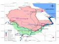
from the beginning of the province to the end of Ha Tinh province, passing through the territory of 5 districts Nghi Xuan, Loc Ha, Thach Ha, Cam Xuyen and Ky Anh. This is also one of the "four basic terrain types in Ha Tinh": mountainous area, midland area, plain area (inland) and coastal area [15, p.48].
Based on the above factors, the coastal area of Ha Tinh currently has 35 communes: Xuan Hoi, Xuan Truong, Xuan Dan, Xuan Pho, Xuan Hai, Xuan Yen, Xuan Thanh, Co Dam, Xuan Lien, Cuong Gian (belonging to Nghi Xuan district), Thinh Loc, Thach Kim, Thach Bang, Thach Chau, Mai Phu, Ho Do (belonging to Loc Ha district), Thach Ban, Thach Hai, Thach Lac, Thach Tri, Thach Van, Thach Hoi (belonging to Thach Ha district), Cam Hoa, Cam Duong, Thien Cam town, Cam Nhuong, Cam Linh (belonging to Cam Xuyen district), Ky Xuan, Ky Phu, Ky Khang, Ky Ninh, Ky Ha, Ky Loi, Ky Phuong, Ky Nam (belonging to Ky Anh district). The coastal communes of Ha Tinh are all directly affected and influenced by the marine environment.
1.3. Overview of Ha Tinh coastal area
1.3.1. Geographical location, natural features, population, economy and culture
1.3.1.1. Geographical location, natural features
Ha Tinh province belongs to the North Central Coast region with geographical coordinates from 17 0 53'50'' to 18 0 45'40'' North latitude and 105 0 05'50'' to 106 o 30'20'' East longitude, 340 km south of Hanoi capital, bordering Nghe An province to the north, Quang Binh province to the south, the East Sea to the east, the Truong Son mountain range to the west, bordering the Lao People's Democratic Republic. The natural land area is 6,025.6 km 2 , accounting for about 1.7% of the country's area. Ha Tinh's terrain is narrow and gradually slopes from West to East, in the West there are many high mountain ranges; below is a low hill area like an upside-down bowl; next is a narrow strip of plain running to the sea; finally there are coastal sandbanks with many coves and bays. Overall, Ha Tinh's terrain has 4 types: mountainous area, midland hill area, plain area (inland) and coastal area.
The coastal area of Ha Tinh accounts for less than 10% of the province's area, with a coastline of 137km, the average terrain is about 3m above sea level, winding at a low level to the estuary from the western mountainous region, narrowing further to the south.
The North borders the sea of Nghe An province, the South borders the sea of Quang Binh province, the East borders the East Sea, the West is a small, narrow inland area divided by mountain ranges and rivers. Along the coast of Ha Tinh, there are four river mouths (sea mouths): Cua Hoi, Cua Sot, Cua Nhuong and Cua Khau. Along the coast of Ha Tinh, there are many mountain ranges jutting out to the sea, most of which are on the southern coast (from Thach Ha district and below) such as: Nam Gioi mountain (Thach Ban, Thach Ha), Thien Cam mountain (Thien Cam town, Cam Xuyen), Ban Do mountain, Cao Vong mountain, Chop Co mountain (Ky Dau mountain), Deo Ngang (Ky Anh district). In contrast to the southern coast, the northern coast (belonging to Nghi Xuan district) has a relatively flat terrain, without mountains, with a length of 32km, separated from the coast of Loc Ha district by Hong Linh mountain. The mountains along the coast of Ha Tinh are not very high.
Regarding climate, the coastal area of Ha Tinh shares the same climate characteristics of the province, located in the tropical monsoon climate zone with the characteristics of the Northern climate. The average temperature in Ha Tinh is usually high, the air temperature in winter is lower than in summer, the average in winter is usually from 18 - 22 degrees Celsius, in summer from 25.5 - 33 degrees Celsius. The coastal area of Ha Tinh, as well as Ha Tinh in general, has a lot of rain, except for a small part in the north, the remaining areas have an average annual rainfall of over 2000mm, in some places over 3000mm.
Ha Tinh Sea has a continental shelf area of 18,400 km2 , with two hot ocean currents.
Warm and cool currents flow in opposite directions, mixing together. One current is about 30 - 40km from the shore, the other is farther out and deeper. The sea area with two mixed water masses is usually located at a depth of 20 - 30m, this is where fish often live. The surface water temperature also changes seasonally, the maximum temperature in July and August has an absolute value of about 30 - 31 o C and the minimum in December to March is about 18 - 22 o C,
Water temperature also increases gradually towards the South and Southeast. Ha Tinh sea has many small islands located near the shore: 4km from the coast of Nghi Xuan district are Hon Nom and Hon Lap; offshore Cua Nhuong district, Cam Xuyen district, 5km from the shore is Hon En, 2km from the shore is Hon Booc; in the south of Ky Anh district, 4km from the coast of Ky Loi commune, there is Son Duong island with an altitude of 123m, further to the East is Hon Chim, ...
The sea of Ha Tinh has a tidal regime, depth, geomorphology, topography, seabed contours, Northeast monsoon... so it has full phytoplankton of the Gulf of Tonkin, with 193 species of algae, the amount of alluvium of the Red River, Ma River, Ca River (Lam River) creates many food sources for seafood to live and reside. Therefore, Ha Tinh sea has great potential for seafood, with an estimated fish reserve of 86,000 tons (bottom fish reserve of 45,000 tons, pelagic fish 41,000 tons), of which there is a potential to catch 54,000 tons/year, with 267 species of fish belonging to 97 families, of which 60 species have high economic value. Shrimp reserves are about 500 - 600 tons, with 27 species of shrimp, squid reserves in the open sea are 3,000 - 3,500 tons,...
In addition, due to natural characteristics, terrain, structure, ... the coastal area of Ha Tinh also has great potential in many aspects, such as: there are many beautiful beaches that can be invested in building coastal tourism-urban areas such as: Thien Cam beach (Cam Xuyen district), Xuan Thanh beach (Nghi Xuan district), Deo Con beach, Ky Ninh beach (Ky Anh district), Thach Bang beach (Loc Ha district), Thach Hai beach (Thach Ha district), ... there are many tidal flats, sand dunes, wetlands, coastal sand strips, ... very favorable for salt production and aquaculture of brackish and salty seafood, ... The sea area of Ha Tinh is also in a favorable geographical position for developing maritime economy and international trade, that is: located on the corridor of international maritime routes, is the gateway to the sea of Laos and Thailand through National Highway 12A, has National Highway 1A, North-South highway passing through (and in the future will connect with the National Railway). The coastal area of Ha Tinh has potential for a system of seaports, including: Xuan Hai commercial port (currently has 2 wharves designed for 1,000DWT ships), Cua Sot fishing port, Cam Nhuong fishing port, Xuan Hoi fishing port, Cua Khau fishing port, ... especially the deep-water port cluster of Vung Ang - Son Duong, an international seaport capable of receiving ships from 50,000 to 200,000 tons, ... The coastal area of Ha Tinh has potential for large mineral resources, such as: Thach Khe iron mine with reserves of about 544 million tons, with Fe content of 61.39 to 62.38
%; Titanium ore in Ky Anh coastal area has reserves of over 5.3 million tons, is rich ore, Ilmenite content from 63.3 to 147.4 kg/m 3 , Zircon from 3-5.2 kg/m 3. From 1999 to now, coastal mineral exploitation has been carried out, including products from Titanium and
Currently exploiting Thach Khe iron mine.
With rich potential and advantages, the coastal area of Ha Tinh in the period of industrialization and modernization is becoming a key economic zone of the North Central region, strongly attracting domestic and foreign investment. This situation makes the coastal area of Ha Tinh from a homogeneous economy and culture, gradually being differentiated into new economic zones with the characteristics of the period of industrialization and modernization. Currently, in the coastal area of Ha Tinh, new economic zones are being formed: fishing economic zones, concentrated in estuary communes (Xuan Hoi, Thach Kim, Cam Nhuong, Ky Ninh); tourism economic zones, concentrated in communes with beautiful beaches (Xuan Thanh, Thach Bang, Thien Cam, Deo Con, ...); Industrial economic zone, concentrated in areas rich in mineral resources with characteristics of deep seaports, convenient transportation, large ships can enter and exit easily, that is the coastal communes of Ky Anh district, connected to the deep-water port of Vung Ang - Son Duong, including coastal communes of Ky Nam, Ky Phuong, Ky Loi, Ky Ninh, ...
However, besides its potential and advantages, Ha Tinh sea is also affected by harsh climatic conditions, unfavorable weather, and is often affected by natural disasters; the impact of climate change and rising sea levels, leading to strong sea erosion, directly affecting the lives of coastal communities.
1.3.1.2. Population characteristics
* The process of forming coastal residents in Ha Tinh
Documentary sources show that Ha Tinh is an ancient land. In prehistoric times, there were residents of the Quynh Van culture and Bau Tro culture, traces left behind are archaeological sites that archaeologists have found in Thach Ha, Cam Xuyen, Ha Tinh city, Can Loc, Duc Tho, Nghi Xuan and some locations in Huong Son, Huong Khe, ... All archaeological sites have provided documents to prove that residents of the Son Vi culture, residents of the Quynh Van culture, residents of the Bau Tro culture once existed and developed on this land. Particularly noteworthy are the residents of the Quynh Van culture and residents of the Bau Tro culture, residents of these two cultures are known by archaeologists.
Research confirms that the inhabitants were of a maritime culture. In the piles of remains left by the inhabitants of the two cultures of Quynh Van and Bau Tro, there are bones of very large marine fish. From those traces, scientists believe that the inhabitants of these two cultures went out to sea and caught large fish in the sea to eat and left the bones of those fish in the piles of remains. Most of the archaeological sites of the Quynh Van and Bau Tro cultures found in Ha Tinh are only 4 - 12km from the present-day coast, namely: archaeological sites in Thach Lac, Thach Lam, Thach Dai, Thach Vinh in Thach Ha district; Cam Thanh relic in Cam Xuyen district; Phoi Phoi beach relic in Nghi Xuan district; Nai Mountain relic - Ha Tinh city,... Based on the collected relics as well as the thickness of the cultural layer and the dense distribution of 12 archaeological sites belonging to Bau Tro culture on Ha Tinh land, archaeologists concluded that "the residents of Bau Tro culture had a long-term settled life on Ha Tinh land and tended to go out to the sea and exploit the sea" [55, p.152].
Historical documents also show that during the Hung King period, the land of Ha Tinh belonged to the Cuu Duc department, one of the 15 departments of the Van Lang country. Hoanh Son mountain (Deo Ngang) was the southern border of the Van Lang state with the Ho Ton state (later the Lam Ap country, then Champa in 808). "Hoanh Son was the southern border of the Van Lang country" [35].
During the period of Chinese domination, some documents show that the residents of the coastal areas of Nghe Tinh (including present-day Ha Tinh and Nghe An), from Quynh Luu to Ky Anh, in addition to rice cultivation, used boats to go out to sea to fish and knew how to dry seawater to get salt. Through the feudal dynasties, "in Ha Tinh, there were Cham people, Chinese people and even a few Japanese people who came to reside, live, do business and trade. But today, their descendants have become Vietnamized and a part of them returned in the years after World War II. That interweaving still leaves the cultural imprints and customs of those ethnic groups in the lives of Ha Tinh residents" [87].
In later stages of development, especially under the Le and Nguyen dynasties, for many reasons such as: "Finding a strange land", taking refuge from foreign invaders, civil wars between feudal dynasties, joining the army, becoming mandarins, etc., residents from some places came to live in Ha Tinh (usually seaports and coastal areas - convenient locations for transportation).
waterway - a popular means of transportation in the history of our nation) and then stayed to build a career on this land. Therefore, the residents of Ha Tinh had people from the northern provinces (Nghe An, Thanh Hoa, the Northern Delta), people from the interior (Quang Tri, Quang Binh), Bo Lo people residing (the remains of which are quite numerous at the seaports of Nghe An and Ha Tinh), and people from the North,... In the 7th and 8th centuries (AD), Bo Lo people came to reside. During the Southern Song Dynasty, they were defeated by the Yuan-Mongol army at Nhai Son. On the way to escape, many loyal and righteous men of the late Southern Song Dynasty fled to Vietnam and Nghe Tinh to seek refuge. They mostly resided in coastal villages. Since then, in addition to the indigenous residents, residents who came to reside from previous centuries, there have been many families and people from the Northern Delta, Thanh Hoa, and the South who came to reside in the coastal villages of Ha Tinh for many different periods of time. Now they live in village communities in the coastal villages of Nghe Tinh [35].
Among the migrants from other places who came to live in the coastal areas of Ha Tinh, there were ancestors who founded the village, and their descendants have now been localized. The books: District Geography, Commune Party History, "Ha Tinh Ancient Village" edited by Thai Kim Dinh, mentioned the origin of the population of some coastal villages of Ha Tinh.
In addition to written sources, the mark of this migration is also preserved in the relics worshiping the characters who founded the village, such as: In Xuan Hai commune (Nghi Xuan district), there is a temple to worship Dinh Cong Tru (father of King Dinh Tien Hoang later) who was an official under the Ngo dynasty, held the position of Hoan Chau governor, brought people from the Red River and Ma River to exploit the land on both sides of the Ca River to establish Dan Hai village (Xuan Hai commune today), a pair of parallel sentences at his temple in Xuan Hai commune today mention this. In Hai Khau village (Ky Ninh commune, Ky Anh district today), there is still a temple to worship the village founder, Le Huu Truyen (Le Huu Trac's younger brother) who came from Hai Duong to establish Hai Khau village,...
Thus, the coastal residents of Ha Tinh have mixed origins. In addition to the pre-residence group, there are also residents from other regions who came to open up their land, make a living, and then stay. Although they have different origins, but they settled on the same land, shared the same living environment, and shared the same benefits from the sea, they have