Home / Hydrology

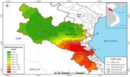
Rainfall Distribution Map From 16-30/ix/1978 - Ca River Basin

6 10/2010 400.5 473.8 927.1 225.3 281.2 496 7 10/1983 301.9 375.2 613.9 159.4 264.0 518 8 09/2002 317.2 384.5 664.9 201.5 234.7 545 9 10/1988 673.1 894.6 908.4 623.8 510.7 666 10 09/1978 814.2 1434.4 1196.7 535.1 646.2 780 According to statistics in Table 2.7 , in the 10 largest floods in the ...

List of Hydrological Stations Operating in the Ca River Basin

37 Figure 2.1: Map of hydrometeorological station network in Ca River basin Currently, there are 16 hydrological stations in the basin (Table 2.2 ) including: + 08 level I hydrological stations: My Ly, Quy Chau, Nghia Khanh, Muong Xen, Dua, Yen Thuong, Hoa Duyet and Son Diem; measurement factors ...

Overview of Flood Studies in the World and Vietnam

CHAPTER 1. OVERVIEW OF STUDIES ON FLOODING IN THE WORLD AND IN VIETNAM 1.1. Some concepts of inundation and flooding Flooding is the phenomenon of water infiltration caused by heavy rain on the surface of a low-lying area [ 20]. Flooding is the phenomenon of inundation caused by water from a river ...

Natural Features, Flood Control and Drainage Dyke System of the Study Area

Discharge into the reservoir location. The discharge works include: culverts, free spillways, gates. Therefore, it is impossible to set up reservoir operations according to the process in the MIKE model. 11. Normally, to solve the problem of flood discharge management according to the reservoir ...

Home Reference Doccument