(iv) Social capital, which is the number of groups or organizations to which adults in the household belong, and the number of relatives to whom the household can turn for help;
(v) Physical capital, considering local (community) infrastructure, including irrigation, bridges, roads, electricity, water supply systems, offices, schools, health stations, cultural houses, markets, etc. that households can use equally [49, p. 15] .
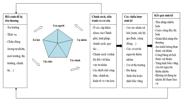
Figure 1: Sustainable Livelihood Analysis Framework
Maybe you are interested!
-

 Training on organizing experiential activities for teachers of ethnic minority boarding secondary schools in Nam Po district, Dien Bien province - 14
 -
 The Chinese and Ngai ethnic groups in Vietnam and the Han ethnic group in China
 -
 Some Common Characteristics of Ethnic Minority Culture in Quang Nam Province
 -
 Dao, Pa Then, San Diu Ethnic Groups in Vietnam and Yao Ethnic Groups in China
 -
 Training on organizing experiential activities for teachers of ethnic minority boarding secondary schools in Nam Po district, Dien Bien province - 13
Source: DFID (2004)
1.2.2. Concepts
1. 2.2.1. Concept of livelihood
Livelihood is a concept that is of interest to researchers today, although the concept of livelihood is understood in one way or another and used at different levels . But the concept of " livelihood " in the simplest understanding is " the way people make a living " . A more complete definition of livelihood by Chambers and Conway is: " Livelihood includes
capabilities, resources and activities required for a means of living ” (Chambers and Conway, 1992, p. 5). Livelihood research by Ethnologists/Anthropologists often relies on the analysis of the sustainable livelihoods framework of the UK Department for International Development (DFID, 2001).
1.2.2.2. Concept of sustainable livelihood
As presented above, livelihood is not only about capabilities and assets but also includes material and social resources and activities necessary to
make a living (DFID, 1999, p.4). But one
important question
g ok
set out
What is a “sustainable livelihood” when the concept of livelihood is becoming increasingly important in discussions and analyses of social development? Defining what is a sustainable livelihood in a particular context is still a
must continue to be discussed (Scoones, 1998, p. 14). But in general, a livelihood
ok
considered resilient when it has the ability to respond and recover when impacted .
or can enhance capabilities and assets both now and in the future while not undermining the natural resource base ( Hanstad et al., 2004, p. 1; Carney, 1998, p. 4). Another widely accepted definition of livelihood by Robert Chambers is "the ability of people to earn a living and improve their quality of life without jeopardizing the livelihood choices of others now and in the future".
1.2.2.3. Immigrant
Migration is the movement of people from one territorial unit to another in a certain period of time accompanied by a temporary or permanent change of residence. In other words, migration is the process of population movement or the process of people leaving or integrating, or establishing a new residence in an administrative-geographical unit in a certain period of time. Migration can involve the movement of an individual, a family, or even an entire
a community. In terms of migration direction, it is internal migration; In terms of destination area, it is according to the type of Rural - urban, Urban - urban, Urban - rural and Rural - rural; In terms of law, it is according to the form of organized migration, forced or voluntary. For the type of migration of NN2 hydropower plant, it is a type of forced migration with the form of area being Rural - Rural, taking place within the framework of the legal programs of the Lao Party and State. Accordingly, migrants receive support to stabilize their lives from the NN2 hydropower project management board, and are oriented by the project to the area of residence and new jobs for the people [34. pp. 35-41].
1.2.2.4. Resettlement
Resettlement (RT) is the relocation of a household, a group of people or an entire community to a new place of residence. This concept directly affects the lives of people when they lose their assets, income or means of livelihood due to a development project and must restore the lives of affected people. Therefore, RT includes the implementation of compensation policies for damages when land or assets of people are recovered. Restoring the lives of affected people can be paid in cash or other assets (houses, land, money, etc.) to compensate for the source of living, material benefits and spiritual benefits for people according to State regulations. In other words, the party using land or property due to the project implementation process is a form of civil liability to compensate for material and spiritual losses to the damaged party, but this damage is not due to illegal acts (of the investor or the State) but is essentially the result of "destruction - reconstruction" in the process of socio-economic development of the country.
1.2.2.5. Livelihood Change
Livelihood transformation is a basic concept in this study, suggesting the change in people's livelihood after resettlement. This definition is directly related to the two concepts of migration and resettlement. When people have their land recovered, lose their assets, income sources or means of livelihood caused by development projects and must be responsible for restoring their lives [emphasis again]. This restoration has caused people's livelihoods to change abnormally. At the same time, in the concept of migration, when people move from one territorial unit to another for a certain period of time, accompanied by a temporary or permanent change of residence, it also causes their livelihoods to change accordingly. In other words, the old livelihood will be replaced by a new and different livelihood, expressed through: food, accommodation, clothing, work, life needs, etc. This change in livelihood can make people's lives better than before, the same as before or worse than before .
Thesis livelihood transformation analysis framework
Construction of NN2 Hydropower Plant and Resettlement Policy
Livelihood impacts of migration and implementation (2011)
Livelihood changes of people after resettlement in Phonesavat village
(After 2011)
Agricultural economic transformation
Transforming the Craft Economy
Forestry economic transformation
Natural economic change
Economic and commercial transformation
1.3. Overview of the research area
1.3.1. Phonesavat Version (Destination)
Phonesavat is the research area for the thesis, located in Muong Phuong district, Vientiane province. Phonesavat is a place with advantages in developing agricultural and commercial economy because it is close to the center of Vientiane province about 90 km [8, p.7]. Over the years, Muong Phuong district in general, Phonesavat village in particular, has contributed revenue to the budget of Vientiane province, especially rice production and some natural minerals with an average value of 5% of the total revenue of the province. In 2006, when the Lao government signed the contract to build the NN2 hydropower plant, Phonesavat village was chosen to build a resettlement area for people of the NN2 hydropower plant with an area of 2,000 hectares, previously a forest area. In terms of geographical location, the South borders Muong Phuong district town, the North borders Kasi district, the East borders Vang Vieng district and the West borders Muong Met district. This place is about 150 km west of the old place (Muong Phun district).
The Phonesavat resettlement area has natural characteristics of an average annual temperature of 28 0 C, the highest is 38 0 C and the lowest is 22 0 C. The rainy season starts from June to October, the average annual rainfall is 1,600 mm to 2,200 mm and is unevenly distributed in space and time. The dry season starts from November to May, at this time the climate is very hot and sunny. The average wind speed during the year is 2.8 m/s, the highest is 3.4 m/s and the lowest is 1.8 m/s. The hydrological system is quite diverse but mainly concentrated in the East with relatively strong flows, the rivers all flow in the North-South direction, including the Nam Lit River and the Nam Tong River, which are the two largest rivers. These two rivers are the source of water for domestic use and irrigation for agricultural production of people in the area. But, every rainy season, these two rivers often appear large and cause floods to people's production areas, especially
rice fields and food production gardens. In terms of terrain, the North of Phonesavat village consists of high, steep mountains with many trees or dense forests. The highlight is the flat area accounting for 60%, convenient for trade and travel, economic infrastructure development and convenient agricultural economic development. However, besides the conveniences, there are difficulties because Phonesavat village is located in a tropical climate zone, subject to hot southwest winds, which often cause damage to the growth of crops and livestock, especially in March to April every year.
In accordance with Decree No. 192 of the Lao Government, Phonesavat village has developed some infrastructure such as: roads, electricity, water, schools, medical stations, markets and new housing for people. In 2011, people moved to Phoensavat village, including 1,176 households, with a population of 7,173 people. Of which, the Khmu ethnic group accounts for 67% of the population, Lao accounts for 25% and H'Mong accounts for 8% [22 pp. 28-37].
1.3.2. Characteristics of old residence (Departure place)
Muong Phun district is the place where the resettled people of Phonesavat village go, located about 200 km northeast of the center of Vientiane province or about 35 km upstream of Nam Ngum1 hydropower plant. The total natural area is 203,589 ha, of which 26,348 ha have been exploited for production, the residential area is 1,653 ha. The area is mostly forests, mountains and streams. Before 2011, Muong Phun district belonged to Vientiane province (now Xaysombun province) with borders with the following areas: To the north it borders Xieng Khouang province, to the south it borders Muong Hom district, to the east it borders Xaysombun district and to the west it borders Vang Vieng district. In terms of terrain, the mountainous area accounts for 90% and the plain area accounts for 10%.
The terrain is uneven due to many high, steep mountain ranges and complex small streams. The average annual temperature is from 22 0 C to 36 0 C,
The average rainfall is 1,600mm to 2,200mm, the average wind speed in the year is 2.8m/s, the highest is 3.4m/s and the lowest is 1.8m/s. The area has a very rich hydrological system, of which the Nam Ngum River and the Nam Phun River are the two largest rivers and are the source of water for daily life and irrigation for the people. The forest also occupies an area of about 3/4 of the total area of the district. The forest is not only diverse in rare flora and fauna but also diverse in food, which is very convenient for people to make a living. Muong Phun is a mountainous district but is home to many ethnic communities that have lived there for a long time, namely the Kho Mu, Lao and Hmong people. The total number of villages in the district is 38 and the population is about 28,165 people, of which the Khmu people account for 66% of the population, the Lao people account for 24% of the population and the Hmong people account for 10%. The ethnic groups live scattered in the highlands, valleys and riverine plains along the roads. Regarding infrastructure, the main traffic routes are the national highway from Vientiane - Saysombun, in addition to the routes from the villages in the district, but the roads are mainly very rudimentary dirt roads. There is 1 high school, 1 hospital in the district center and some offices of the local government. Among the above villages and properties, the NN2 Hydropower Project caused damage to 17 villages, 1,176 households, with a population of 6,871 people. According to the assessment, the highlight of the old place of residence of the people is the place with advantages in natural resources such as: large land, dense forests, many streams and rich vegetation and forest animals. At the same time, the climate and weather are also very suitable for crops and livestock. The people's livelihood is easier. However, besides the strengths, there are also weaknesses such as: difficult traffic, rudimentary infrastructure and distance from commercial centers. The products produced are mainly self-sufficient and are rarely sold on the market to generate economic income for the family [22 pp. 9-15].
13.3. Introduction of ethnic groups resettled in Nam Ngum 2 Hydropower Plant
13.3.1. Some features of the Khmu people
The Khmu people originated from Xieng Khouang province during the resistance war against the French (1945). This ethnic group mainly resides in the mid-mountainous areas and is scattered according to farming and hunting-gathering conditions. The main crops in cultivation are mainly sticky rice, corn, cassava, potatoes, taro, gourd and squash. The main livestock are chickens, pigs, goats, buffaloes and cows. The main means of production are knives, axes, sticks, and hoes. The objects in hunting and gathering are mushrooms, wild vegetables, bamboo shoots, fruits and hunting birds, rats, squirrels, wild chickens, deer, pigs, etc. In addition to hunting, people also go fishing and catching fish along rivers, streams and ponds. In terms of material culture, the traditional house of the Khmu people is a half-floor, half-ground house and is built on the mid-mountainous area. Nowadays, the Khmu people rarely build half-floor houses but build low houses and are seen more in the flat areas. Regarding costumes, according to recorded documents, weaving and spinning are not developed in the Khmu community, so their traditional costumes have similar features to those of the Lao people. However, there are also differences such as: shirts dyed in black indigo, round neck, short sleeves, red embroidered patterns on the cuffs and collar. Regarding spiritual culture, the Khmu have had their own traditional cultural activities for a long time, such as celebrating the Kreer festival. This festival takes place every year in February after the harvest. During the festival, the spirits of rice, corn, potatoes, cassava, gourds, squash, etc. are considered as the spirits of the household. In addition, they ask those spirits to protect them from poverty in the coming year. Besides, the Khmu people believe in village gods. At the entrance of the Khmu village, the villagers built a house to worship the village god and consider it a sacred and mysterious space. If someone commits a crime in this area, it is believed that misfortune will befall that person. To this day, the Khmu still maintain this custom. Regarding wedding customs, the