Morinda officinalis; Codonopsis javanica ... had to be included in the Vietnam Red Book (1996) and the Red List of Vietnamese Medicinal Plants (1996, 2001, 2004) to recommend protection.
- Especially for some medicinal plants such as Morinda officinalis, Panax pseudoginseng and wild ginseng, Coptis chinensis, One-leaf orchid,... are facing a high risk of extinction (Nguyen Van Tap, 2005) .
Cao Bang is a province with many ethnic groups living together with unique folk experiences in using wild plants to make medicine. However, research on medicinal plants in Cao Bang is still limited, not fully and systematically studying the indigenous knowledge of the ethnic communities living in the province. Conducting a comprehensive investigation and research on medicinal plant resources in the whole province will contribute to adding valuable documents to the treasure of traditional medicine in Vietnam and the world to serve the work of conservation and scientific research.
1.3. Studies on vegetation, plant diversity and medicinal plants in Cao Bang and the research area
Research on vegetation, plant diversity and medicinal plants in Cao Bang province is still limited, there are only a few research works:
Le Vu Khoi (2003) when studying the biodiversity of the Thang Hen limestone mountain area, Tra Linh district, Cao Bang province identified 340 species, belonging to 233 genera, 84 families of 4 vascular plant phyla: Pinus, Ferns, Gymnosperms and Angiosperms. Some typical species in the research area are Pseudotsuga brevifolia , Pinus kwangtungensis var. varifolia , especially species in the Orchidaceae family.
Nguyen Huu Tu and colleagues (2009) when studying the flora in Cao Vit Gibbon Conservation Area, Trung Khanh, Cao Bang identified 6 main types of vegetation in the research area including: subtropical evergreen broadleaf forest in the valley, bamboo forest in the valley, subtropical evergreen broadleaf forest on the mountainside, subtropical evergreen mixed broadleaf and gymnosperm forest in the summit area, secondary evergreen tropical shrubland and secondary evergreen tropical grassland. The flora has been listed as 960 species, 541 genera, 144 families, belonging to 4 phyla of plants.
vascular plants (Pine, Fern, Gymnosperm and Angiosperm). The life form spectrum has been established as SB = 76.4 Ph + 8.9Ch + 4.4 Hm + 3.6 Cr + 6.7 Th. The geographical factors with the largest number of species include India, South China, tropical Asia and Indochina. 10 groups of uses have been recorded (medicine; food; timber, firewood; ornamental; fatty oil; fiber; essential oil; tannin; dye; pet food; construction materials and plastics) and 34 rare species according to the Vietnam Red Book (2007).
Tran Cong Khanh (2012) pointed out that, in the period from 1969-1973, Cao Bang province had 617 medicinal plant species distributed in all 13 districts and towns in the province and a team of 800 traditional medicine practitioners with many folk remedies and valuable experiences in health care and treatment. Many valuable medicinal species are distributed in localities such as Bao Lac district: Red Polygonum multiflorum, Polygonum multiflorum. Thong Nong, Nguyen Binh, Ha Quang districts: Aconite, Bear gall root, Tea tree, Morinda officinalis, Betel nut, Yellow vine, Seven leaf one flower, Green sky vine, Chicken blood vine, Purple castor oil, Amomum, Kim tuyen. Thach An, Hoa An districts: Bone-strengthening bone, Lime root, Wolfberry, Bitter tea, Cau ginseng. Trung Khanh, Tra Linh, Ha Lang, Quang Uyen districts: Gynostemma pentaphyllum, Silver honey, Eucommia ulmoides, Kim anh, Cau tich, etc. The author also makes some recommendations for the conservation and development of valuable medicinal plants in the locality.
Tran Thi Thu Thuy, La Quang Do, Nguyen Quang Hung (2014) when studying the flora in Phia Oac - Phia Den Nature Reserve identified the composition of rare and endangered plant species in the NR including 33 species belonging to 27 genera, 20 families belonging to 3 different plant phyla. Of which, 8 species are at the world level (IUCN, 2011), 16 species (7 species belonging to group IA and 9 species belonging to group IIA) are recorded in Decree 32/2006/ND-CP. The life forms of rare plants in the study area have 3 main life forms: above-ground shoots, close-to-ground shoots and hidden shoots. The proportions of life forms are different, the group with the highest proportion is the above-ground shoot group (Ph) accounting for 78.79%, the least is the hidden shoot group (Cr) 3.03%.
On December 30, 2014, the People's Committee of Cao Bang province approved the biodiversity conservation plan of Cao Bang province until 2020, with a vision to 2030. In which, the Phia Oac - Phia Den Nature Reserve was upgraded to a National Park.
Phia Oac - Phia Den National Park aims to protect intact forest ecosystems; rare and precious forest flora and fauna genetic resources (including 47 plant species and 66 animal species); natural landscapes, with a natural area of 11,960 hectares, in Nguyen Binh district, on the territory of Ca Thanh, Mai Long, Phan Thanh, Quang Thanh, Thanh Cong communes and a small part of Tinh Tuc town and Vu Nong commune.
1.4. Natural conditions - Socio-economic conditions of the research area
1.4.1. Geographical location
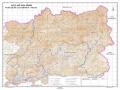
Phia Oac - Phia Den National Park has a total natural area of 10,593.5 hectares, including 8,146.6 hectares of natural forest in 5 communes of Nguyen Binh district, Cao Bang province: Thanh Cong, Quang Thanh, Phan Thanh, Hung Dao and Tinh Tuc town. The entire area of the national park is located in Non Nuoc Cao Bang Geopark, recognized by UNESCO as a Global Geopark on April 12, 2018. Located 240 km from Hanoi capital along provincial road 212, 76 km from Bac Kan city along provincial road 212 and national road 3, 73 km from Cao Bang city along provincial road 212 and national road 34, and 30 km from Nguyen Binh town along provincial road 212. Geographical location as follows:
- From 105 0 49 ' 53 '' to 105 0 56 ' 24 '' East longitude
- From 22 0 31 ' 44 '' to 22 0 39 ' 41 '' North latitude
+ To the North, it borders Thong Nong district and Bao Lac district, Cao Bang province.
+ To the East, it borders Hoa An district, Cao Bang province.
+ South borders Bac Kan province
+ The West borders Bac Kan province
The total natural area of the 5 communes is 10,593.5 hectares, accounting for 12.64% of the total area (20 communes) of the district.
Table 1.1: Planning area of Phia Oac - Phia Den National Park
Total area (ha) | Strictly protected area (ha) | Ecological restoration area (ha) | Administrative service area (ha) | Note |
Maybe you are interested!
-
 Study on diversity and biosynthesis of Cyclooligomer depsipeptide of entomopathogenic fungi in Copia Nature Reserve and Xuan Son National Park - 27
 -
 Study on diversity and biosynthesis of Cyclooligomer depsipeptide of entomopathogenic fungi at Copia Nature Reserve and Xuan Son National Park - 2
 -
 The Role of Tam Dao National Park in Biodiversity Conservation and Environmental Protection in the Northern Delta Region and Vietnam
 -
 Overview of Bidoup – Nui Ba National Park, Lam Dong Province
 -
 Cat Ba National Park (Source: Internet, Accessed June 15, 2018)
Phia Oac - Phia Den National Park
10,593.5 | 4,035.5 | 6,417.1 | 140.9 |
The national park is divided into 3 main sub-zones: strictly protected sub-zone; ecological restoration sub-zone; administrative service sub-zone. Of which, the strictly protected sub-zone has an area of 4,035.5 hectares, in sub-zones 338, 352 Thanh Cong commune; sub-zones 333, 334 Quang Thanh commune; sub-zones 327, 337 Phan Thanh commune; and sub-zones 321, 322 Tinh Tuc town. Here, there is a tropical and sub-tropical humid evergreen closed forest ecosystem; a dwarf forest ecosystem, also known as "moss forest", a type of forest with a temperate climate typical of Northern Vietnam, along with many endemic, endangered, and rare species of flora and fauna. In addition, the buffer zone has an area of 8,276.1 hectares located in 6 communes and 1 town.
The highest mountain peak in the nature reserve is Phia Oac peak at 1,931 m, which is also the highest peak in the Ngan Son-Yen Lac arc.
1.4.2. Topographic and geomorphological features
The terrain in the national park is complex, with mainly high mountains, small narrow valleys, large slopes, many steep places. There are many mountain peaks over 1,000m to nearly 2,000m above sea level, such as Phia Oac (1,935m), the second highest peak in Cao Bang; Niot Ti (1,574m); Tam Loang (1,446m); Phia Den (1,391m); Ki Doan (1,165m)... In terms of geology, this place has a mix of terrigenous rocks, limestone and granite intrusive rocks, creating ranges of soil mountains interspersed with rocky mountains. The diversity of terrain, geomorphology, geology, combined with typical climatic conditions have created unique ecosystems of the Phia Oac high mountain area, and are also the foundation for the biodiversity of this area.
The national park has the task of protecting the existing forest area, at the same time restoring and enriching natural forests, cultivating rare native tree varieties for new planting to increase green coverage. Along with that, it is to protect the natural flora and fauna and biodiversity, exploit the potential of landscapes and environmental services to increase revenue, contributing to local socio-economic development.
It is home to many wild animals and plants, especially 90 species of plants and 58 species of animals that are at high risk of extinction.[6] Some notable plant species include false ironwood, stone ironwood, pine pa co, vu huong (an endemic species), lat
flowers, sen honey, nghien, chestnut. Regarding animals, there are about 80 species of mammals, hundreds of species of birds, reptiles and amphibians, tens of thousands of species of insects. Some rare species include musk deer, mountain goat, large loris, small loris, northeastern black gibbon, monkey, black bear, civet, civet, wild cat, white-tailed flying squirrel...
Due to geological formation, the terrain of Nguyen Binh district forms two distinct areas: the rocky mountain area and the dirt mountain area. The average height is from 800m to 1,100m, gradually decreasing from west to east. The rocky mountain area runs in the West - Northwest direction, surrounding the dirt mountain area, gradually decreasing towards the Northeast. From Thanh Cong, Mai Long, Ca Thanh, Yen Lac, Trieu Nguyen, Minh Thanh, Bac Hop communes, connecting the Lam Son and Minh Tam rocky mountain ranges, there are many mountains over 1,000m high. Toong Tinh range (Phan Thanh commune) is 1,120m high, Tam Luong mountain (Thanh Cong commune) is 1,300m high, Phia Oac mountain (Phan Thanh commune) is 1,931m high, covered with clouds all year round. The dirt mountain area includes the mountain ranges in the East and Southeast, successively undulating against the rocky mountain platform, creating a solid pillar, a wall for thousands of years to protect against foreign invasion. These mountain ranges stretch from Hoa Tham, Tam Kim, Lang Mon communes to Quang Thanh, Thanh Cong, The Duc.
Interspersed among the rocky and dirt mountains are undulating hills, 500m high, with green grasslands such as Phia Den (Thanh Cong), Na Nu (Lang Mon). Hills, grasslands, and minerals are the economic potentials of the ethnic people of Nguyen Binh district.
Phia Oac - Phia Den National Park has complex mountainous terrain, high slopes, and difficult roads; causing difficulties for economic development, affecting the daily life as well as the exchange of goods of the people.
In Thanh Cong commune, the center of the research area, there are some mountains such as Phia Chao, Phia Than, Phia Den. Water streams in the area include Ban Dong stream, Ban Se stream, Nam Dan stream, Khau Cang stream, Nam Pac Khuoi Lo, Nam Tong. Provincial road 212 runs from the North to the Southwest of the commune and connects to Bac Kan province.
1.4.3. Geological and soil characteristics
According to the district's soil documents, the area has the following main soil types:
- Red-brown Feralit soil on limestone mountains: Concentrated distribution at altitudes from 700m
-1700m above sea level.
- Pale yellow highland Ferralitic soil: This type of soil has a weak Ferralitic process, a relatively strong humification process, suitable for some plant species: Pine, Sa moc, Tong du, Lat hoa, De do, Trau, So and some other specialty plants, medicinal plants, and fruit trees.
- Low mountain red-yellow Ferralit soil: Distributed at an altitude of 300 - 700m, formed on acidic, neutral-alkaline igneous rocks, gravelly rocks, limestone. The soil contains few primary minerals, has an acidic reaction, this type of soil is suitable for some plant species: Pine, Sa moc, Tong du, Khao vang, Cang lo, Lat hoa, Keo, De do, Trau, So, Anise, Que, Che bien and some other medicinal plants and fruit trees.
- Basin and valley land: Including new and old alluvial soil, sloping soil products, mixed products, this type of land is used for agricultural production.
1.4.4. Climate and hydrological characteristics
* Climate
The study area is located in the tropical monsoon mountainous climate zone, with an average temperature of 20ºC, the highest temperature of 36.8ºC and the lowest of 0.6ºC. The average annual rainfall is 1,670 mm (the highest is 2,049 mm and the lowest is 1,252 mm). The average air humidity is 82%. The climate is subtropical, the lowlands are influenced by the tropical monsoon climate; there are two distinct seasons in a year, which are:
- The rainy season starts from April to October, accounting for 85.4% of the total annual rainfall, concentrated in July and August. The average annual rainfall is 1,592 mm; the highest year is 1,736 mm; the lowest year is 1,466 mm.
- The dry season lasts from November to March of the following year; often affected by the Northeast monsoon, low temperature, little rainfall, lots of fog.
- Average annual temperature is 180C; highest temperature from May to September, between 24.50 - 26.90C, sometimes up to 340C; lowest temperature from November to February of the following year, sometimes down to -20C - 50C.
- The average humidity for the whole year is 84.3%, the month with the highest humidity is July and August at over 87%, the lowest is December at 80.5%.
- In addition, there is also fog appearing in the early morning, late afternoon and evening.
night of all months of the year; the heaviest fog point is the top of Colea Pass. In particular, when the temperature drops, snow appears in the Phia Oac peak and Colea Pass areas. The research area has complex weather and climate, with severe cold lasting all year round.
* Hydrology:
The Nguyen Binh river and stream system includes 3 large rivers: Nguyen Binh River is an upstream branch of Bang River, originating from Tinh Tuc, flowing through The Duc commune, Nguyen Binh town, Minh Thanh, Bac Hop to Truong Luong commune (Hoa An district). The river has a large flow, in places with high slopes such as Ta Sa and Na Ngan, 2 small hydroelectric stations with a capacity of 850kW/hour have been built to supply Tinh Tuc tin mine. Nhien River originates from Phia Oac mountain, Thanh Cong commune, flowing through Hung Dao, Tam Kim, Hoa Tham, Bach Dang communes (Hoa An) is the upstream of Hien River to Cao Bang town, converging with Bang River. Nang River originates from Bao Lac district, passing through Bang Thanh commune (Pac Nam, Bac Kan) and flowing through Mai Long, Phan Thanh, Banh Trach communes (Ba Be, Bac Kan). Along the rivers are small, narrow fields of The Duc, Minh Thanh, Bac Hop, Tam Kim communes. There are also terraced fields on the hillsides in Thanh Cong, Quang Thanh, The Duc communes, and upland rice growing areas such as Hoa Tham and Thinh Vuong communes.
1.5. Socio-economic conditions of the research area
1.5.1. Population, labor
Phia Oac - Phia Den National Park is located in the administrative area of 05 communes and towns: Thanh Cong, Quang Thanh, Phan Thanh, Hung Dao and Tinh Tuc town. With a total area of 10,593.5 hectares, accounting for 12.64% of the total area (20 communes) of the district.
According to the statistics of Nguyen Binh district, as of December 31, 2018, the total population of 05 communes and towns of Phia Oac - Phia Den National Park was 13,872 people, 3,247 households. The population density of the whole region is 71.2 people/km 2 .
Table 1.2. Population in the study area
TT
Administrative unit | Population (People) | Population density (people/ km2 ) | Population growth rate nature (%) | |
1 | Thanh Cong Commune | 2,893 | 35 | 0.55 |
2 | Quang Thanh Commune | 1774 | 39 | 0.71 |
3 | Phan Thanh Commune | 3071 | 37 | 0.68 |
4 | Hung Dao Commune | 1184 | 26 | 0.72 |
5 | Tinh Tuc Town | 4950 | 219 | 0.54 |
Total | 13,872 | 71.2 | 0.64 | |
(Source: Cao Bang Provincial Statistical Yearbook 2017)
The population of the buffer zone is 7,800 people, of which the Dao, Hmong and Nung people make up the majority. The population density is relatively low, only about 71.2 people/km 2 . However, the population growth rate is quite high, averaging 0.7%.
1.5.2. Economic development situation.
The people living in Phia Oac - Phia Den National Park are mainly Dao, Nung and H'Mong people... They have lived here for a long time with the habit of clearing forests for farming, hunting wild animals, grazing cattle and deforestation. Agricultural production is still the main occupation of the people here and due to low productivity and lack of arable land, the average food per capita in terms of rice for the whole area is 650 kg/person, only enough food for 10 months. The income of people in the area in recent years is 9.5 million VND/year. The activities of cutting down forests for farming and building houses due to household separation have significantly affected the forest vegetation. The area of primary forest is no longer large and is replaced by secondary forests recovering, grasslands, shrublands, scattered trees and low-value bamboo forests. In parallel with clearing forests for farming, local people also exploit wood to build houses and exploit medicinal herbs to sell to Chinese traders. Although exploitation here is not large, it focuses on some rare species that affect the structure of the forest as well as the survival of these species.
* Assessing the potential of the commune: