consult experts in developing the basic contents of the Biodiversity Management Plan of the Reserve.
The students conducted a field survey at Bidoup – Nui Ba National Park, Lam Dong Province from April 24, 2013 to April 28, 2013. During this time, the students conducted the following activities:
- Conduct a field survey at the National Park to learn about newly formed tourist routes, survey the newly planted forest area of the Park, participate in field classes (coffee growing process for local communities) organized by the Park Management Board;
- Collect relevant information of the Garden including: basic information of the Garden; recent programs and plans; results of implementation of programs and plans.
- Organize interviews with people in the buffer zone (representatives of 20 households) about their participation in the Park's activities (participation in reforestation, forest protection, ecotourism, etc.)
- Organize work with the Management Board on issues related to the implementation and deployment of the Garden's Programs.
After the field trip, the students conducted research and analyzed the collected information. From there, the students developed criteria and drafted a biodiversity management plan for Bidoup – Nui Ba National Park, Lam Dong Province. From there, the students consulted with experts in the field of biodiversity about the practicality and legality of the research.
2.3.3. Information analysis
In this method, students used different tools to analyze relevant information.
a. SWOT tool
SWOT is the analysis of strengths, weaknesses, opportunities and threats. This is the analysis of internal and external environmental circumstances when building and developing a project or a plan. The difference between internal and external circumstances is based on 2 criteria:
1. Space: Everything within a selected geographic boundary of the system is considered the internal environmental context.
2. Time: Everything that is happening and existing at the present moment is related to internal environmental circumstances, future states and external environmental circumstances.
Use SWOT analysis to analyze strengths, weaknesses, opportunities and challenges to develop a Conservation Area Management Plan for Bioup - Nui Ba National Park that is suitable to the actual situation of the Park.
b. DPSIR tool
The DPSIR method was inherited and upgraded by the European Environment Agency from the PSR analysis method of the Organization for Economic Cooperation and Development since 1994. The DPSIR method is a cognitive model used to identify, analyze and evaluate cause-effect relationships: causes of environmental problems, their consequences and necessary response measures. In other words, DPSIR is used to analyze the current situation, evaluate the impacts of a problem under investigation and propose response solutions.
Students use this method in the process of developing a draft management plan for Bidoup – Nui Ba National Park, Lam Dong province according to the criteria of current laws (Law on Biodiversity, Law on Forest Protection and Development, etc.) to develop a management plan that can thoroughly address the causes of biodiversity loss in the Reserve.
2.4. Research time of the topic
The project was carried out from April 2013 to the end of November 2013 with 01 field trip to Bidoup - Nui Ba National Park, Lam Dong province taking place in April, the time for collecting information, researching and writing the report within 6 months and organizing consultations with experts was conducted in October and November.
The thesis will be carried out according to the Plan that has been carried out by the student according to the table below:
Table 1.1: Thesis completion time
TT
Content | Month | |||||||||
4 | 5 | 6 | 7 | 8 | 9 | 10 | 11 | 12 | ||
1 | Develop and approve detailed outline | x | ||||||||
2 | Data collection and fieldwork, combined with data analysis and writing of literature reviews | x | x | x | x | |||||
3 | Progress report every 2 months | x | x | x | ||||||
4 | Preliminary research report | x | ||||||||
5 | Writing essay | x | x | x | x | x | ||||
6 | Submit thesis (manuscript) | x | ||||||||
7 | Submit final thesis | x | ||||||||
8 | Do protection procedures | x | ||||||||
9 | Thesis defense | x | ||||||||
10 | Closing ceremony | x | ||||||||
Maybe you are interested!
-
 Cat Ba National Park (Source: Internet, Accessed June 15, 2018)
 -
 Research on assessing the impact of tourism activities on resources in Cat Ba National Park - Hai Phong - 1
 -
 Developing a plan to lease special-use forest environment to develop ecotourism at Ba Vi National Park - Hanoi - 12
 -
 Characteristics of Ecotourism Activities of Ba Vi National Park
 -
 Research on assessing tourism potential with forest products in Ba Vi National Park, Ba Vi district, Hanoi city - 1
2.5. Research location of the topic
In order to carry out the research of the topic well and in accordance with the management situation of National Parks nationwide, the students chose the main research location of the topic as Bioup - Nui Ba National Park in Lam Dong province.
Map 1: Topographic map of Bidoup – Nui Ba National Park, Lam Dong province
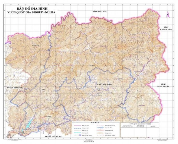
2.5.1 Overview of Bidoup – Nui Ba National Park, Lam Dong province
Bidoup - Nui Ba National Park is located in the northeast of Da Lat plateau in the southern mountainous region of Vietnam, Lac Duong district, northeast of Lam Dong province.
Geographic coordinates:
From 12 0 00' to 12 0 19' North latitude.
From 108 0 21' to 108 0 44' East longitude.
The National Park's territory includes the communes of Dachais, Dasar, Danhim, Dung K'no, Lat and Lac Duong town of Lac Duong district; part of Da Tong commune of Dam Rong district.
Area 70,038 hectares.
Boundaries: West and south: Bordering Serepok River and Da Nhim upstream protection forest, Lam Dong province; North: Bordering Chu Yang Sin National Park, Dak Lak province; East: Bordering Phuoc Binh National Park, Ninh Thuan and Khanh Hoa province.
The terrain of the national park is mountainous and hilly, most of the area is at high altitude.
1,400 m above sea level. The highest peak is Langbian (Nui Ba) in the West at 2,167 m, and Bidoup in the East at 2,287 m.
The hydrology of the national park is the headwaters of the Da Nhim river system, which consists of two main branches, Da Nhim and Da Mong - an important tributary of the Dong Nai river. The headwaters of the Serepok river are the Krong No river - the only river in Vietnam that flows from East to West to Cambodia and joins the Mekong river. The Bidoup-Nui Ba National Park area has annual rainfall ranging from 2,800mm - 3,000mm/year.
2.5.2 Climate
a) Temperature regime: Because Bidoup - Nui Ba National Park is located on medium and high mountain terrain, with an average altitude of 1,500m - 1,800m, surrounded by high mountain ranges, the climate is mainly in the tropical monsoon zone, however, the climate of Da Lat and Lac Duong has its own characteristics of the highlands.
- The average annual air temperature in the area is 18 0 C. January is the coldest month of the year, average temperature: 15.6 0 C. May is the hottest month of the year, average temperature: 19.6 0 C.
b) Rainfall regime: Average annual rainfall is 1,755 mm (highest rainfall was 2,016 mm in 1989, rainfall in 1981 was only 1,356 mm). January has the lowest rainfall of 6 mm. The average dry season is only 5.7 mm. Rainfall in the rainy season ranges from 50 mm to 80 mm. September has the highest rainfall (300 mm). Rainfall in the rainy season accounts for about 80% of the year. The average number of rainy days is 170 days. December, January, February, and March have about 5 rainy days/month. At the high altitudes above
At 1,900m altitudes such as Bi Doup, Hon Giao, Gia Rich, and Chu Yen Du mountains, rainfall can reach 2,800 - 3,000 mm/year and the number of rainy days is also higher.
c) Humidity
- Rainy season humidity reaches above: 85%
- Dry season humidity is below: 80%
- Lowest in February, March reached: 75-78%
- Humidity is lowest at 13-14 o'clock in the day.
d) Fog: Every year, there are about 80 foggy days/year, concentrated in February, March, April, May, with an average of 8 - 16 foggy days/month. In the Bidoup - Nui Ba National Park area, at the high mountain peaks, there are more foggy days every year and cloud cover is more frequent.
2.5.3 Biodiversity of the region
Bidoup – Nui Ba National Park, Lam Dong province is considered one of the four biodiversity centers of the country, with a forest ecosystem of the transition zone between the Central Highlands and the low mountains of southern Vietnam characterized by: medium mountain humid evergreen closed forest, subtropical humid mixed broadleaf and coniferous forest, low mountain subtropical coniferous sparse forest and mixed broadleaf and bamboo forest.
- About species:
+ Flora: Possessing a high level of diversity and endemism in plants: At least 1,561 species of vascular plants, belonging to 5 phyla, 161 families and 681 genera; The number of plant species requiring conservation attention includes 74 species listed in the Vietnam Red Book 2007, Decree No. 32/2006/ND-CP dated March 30, 2006 of the Government on Management of endangered forest plants and animals (Decree 32) and the IUCN Red Book 2009, belonging to 29 plant families; 96 endemic species, including 29 species named after geographical regions:
09 species named after Dalat ( dalattensis )
14 species named after Langbiang ( langbianensis )
06 species named after Bidoup ( bidupensis )
The national park owns the largest orchid gene source in Vietnam (258 species), many of which are endemic to the Da Lat plateau.
+ Fauna: The fauna of the National Park is also very diverse and highly endemic, including 10 orders, 24 families, 75 species. What stands out about the fauna of Bidoup-Nui Ba National Park is the relatively complete presence of large ungulates: Gaur ( Bos gaurus ), Wild buffalo ( Bubalus arnee ), Serow ( Naemorhedus sumatraensis ), Large-antlered muntjac ( Megamuntiacus vuquangensis ), Elephant ( Elephas maximus ). Primates are also quite rich (07 species).
Bidoup - Nui Ba National Park is located in the endemic bird area of Da Lat plateau, including 15 orders, 43 families and 220 species, of which 14 species are listed in the Vietnam Red Book, 17 species are listed in Decree No. 32/2006/ND-CP of the Government on management of endangered, precious and rare forest plants and animals, and 213 species are listed in the World Red Book (IUCN 2009).
Bidoup - Nui Ba National Park is located in Da Lat Plateau, has 3 important bird areas: Bidoup, Langbian, and Cong Troi, so there are many endemic bird species of Da Lat Plateau such as: Black-headed Babbler ( Garrlax milleti ), Grey-cheeked Black-headed Babbler ( Garrulax yersini ), Grey-headed Babbler ( Garrulax vassali ), Brown Pigeon ( Columbapunicea ), Yellow-billed Treecrawler ( Sitta solangiae ), Yellow-throated Sparrow ( Carduelis monguilloti ), Long-billed Babbler ( Jabouilleia danjoui ), Crested Argus ( Rheinardia ocellata ), Brown Heron ( Anorrhinus tickelli ).
In addition, according to Decree No. 32/2006/ND-CP of the Government dated March 30, 2006 on the management of endangered, precious and rare forest plants and animals, bird species that need conservation attention in Bidoup-Nui Ba National Park also include: Purple-breasted pheasant ( Lophura diardi ), Fire-breasted thrush ( Copsychus malabaricus ), Red-breasted parrot ( Psittacula alexandri ) and two threatened species listed in the IUCN Red Book (2004) are Great Hornbill ( Buceros bicornis ), and Wild Kingfisher ( Alcedo hercules ).
From the above data, it can be seen that the flora and fauna of Bidoup - Nui Ba National Park, Lam Dong province can be considered a natural flora and fauna garden.
The vast nature with the remaining primeval forests of Vietnam and Southeast Asia is an endless source of discovery for all tourists and scientists when they set foot in Da Lat city.