In general, people divide data in GIS into 2 types:
- Spatial data tells us the physical size and geographic location of objects on the earth's surface.
- Non-spatial data is data in text form that gives us more information about the object's attributes.
*Human:
GIS technology would be limited without the people involved in managing the system and developing practical GIS applications. GIS users can be technical experts, system designers and maintainers, or people who use GIS to solve problems in their work.
Maybe you are interested!
-

 For the people, all benefits should be done, all harms should be abandoned
 -
 Perspectives on Improving the Quality of Law Application in Resolving Land Use Rights Disputes at the People's Court
 -
 Organizing physical education teaching activities at People's Security College I in the current reform period - 14
 -
 Some Pictures of the Transformation of Traditional Culture of Thai People in Mai Chau
 -
 Recruitment of civil servants at the People's Committee of Luc Nam district, Bac Giang province - Current situation and solutions - 9
GIS users are people who use GIS software to solve spatial problems for their purposes. They are usually well-trained people in the GIS field or experts.
1.2.2. Database in GIS
Currently, the term database is understood as a system of information arranged for a specific purpose and designed to be managed and stored in a computer. There are many types of databases, they are processed by database management software. However, within the scope of this thesis, only issues related to GIS databases are mentioned.
In the structure of a GIS system, the database plays a decisive role in the system and accounts for 80 percent of the theoretical and economic value of the system. Therefore, the database is considered the most important part of GIS and is called the core of the system. A special database includes data on the location and spatial shape of geographic objects represented in the form of points, lines, areas in a vector structure or square cells (pixels) in a raster structure with their non-spatial attribute values.
A database is a repository of capabilities for storing large amounts of data. It includes a number of useful functions as follows (according to Rolf A. de By.ITC):
1. Allows multiple people to use it at the same time, that is, it allows concurrent use .
2. Allows the creation of several technical methods for storing data and allows for the most efficient use, that is, it supports storage optimization .
3. Allows to impose rules on stored data, which are automatically checked after each data update, that is, it supports data integrity .
4. It provides ease of use of data manipulation language, which allows for data rendering and data updating, that is, it has query capabilities .
5. Try to execute each query using the data manipulation language in the most efficient way, i.e. it provides query optimization .
Databases can store almost any type of data and can be built from many sources, of which remote sensing is a very important source of information. However, when entering the database, remote sensing information must be supplemented, edited and selected to become information layers in the GIS database.
The outstanding feature of GIS database is that it includes information that has been arranged and attached to a certain territory. This data system must manage both types of information: spatial and non-spatial.
Spatial data are digital descriptions of map images, including coordinates, rules, and symbols used to identify a specific map image on each map. Geographic information systems use spatial data to create a map or map image on a screen or on paper through peripheral devices, …
Non-spatial data are descriptions of characteristics, quantities, and relationships of map images with their geographic locations. Non-spatial data are called attribute data, which are related to geographic locations or spatial objects and are closely linked to them in the geographic information system through a common unified mechanism.
Geographic data (spatial data) includes the following categories:
Aerospace photo.
Orthophotomap.
Topographic base map created from aerial photographs.
Topographic maps are created from ground survey data.
Cadastral map.
Geographic map synthesized from various types of topographic maps.
The above types of images and maps are all in digital form and saved in vector or mixed raster - vector format. Geographic data in vector form is classified according to the information requirements of information organization. Usually, people classify according to the nature of the information: terrain layer, hydrology layer, traffic layer, population layer, sub-class, administrative boundary layer, etc. In many cases, for deeper management, people will classify more specialized layers such as in the hydrology layer, it is divided into sub-layers: large rivers, small rivers, sea layers, lake layers, etc.
Raster information is source information and supporting information, space is managed as a geographic object. Vector information is directly involved in management and is defined as geographic objects. These objects are represented in 3 forms: points, lines and areas or regions. Each object has its own geometric properties such as size and location. The problem is how to organize, store and display vector information to satisfy the following requirements:
Show all necessary information.
Minimum margin and redundancy.
Quick access to information.
Update information easily and without errors (delete unnecessary information, add new information, correct outdated information).
Convenient for displaying information.
Attribute data (non-spatial data): is information that explains geographical phenomena that have occurred and are occurring. This information is stored in regular data. The problem is to find the relationship between geographical information and attribute information. From the information we can find other information in the database.
Another feature of a GIS database is that it is a relational database, in which data is stored and arranged in tables containing objects and attribute values.
The data linkage reflects the close relationship between two types of information. The linkage ensures that each geographic object is associated with attribute information, reflecting the current status and unique points of the object. At the same time, through it, users can easily look up, search and select objects according to their requirements through the identifier or Index.
1.2.2.1. Spatial information model
Data is the heart of a GIS system, the more it contains, the more meaningful it is. GIS data is stored in databases and is collected through real-world models. Data in a GIS system is also called spatial information. Spatial information features are capable of describing “where things are” through reference locations, units of measurement, and spatial relationships. They also have the ability to describe “phenomena shape” through qualitative and quantitative descriptions of shapes and structures. Finally, spatial information features describe “relationships and interactions” between natural phenomena. Spatial models are especially important because the way information is presented will affect the system’s ability to perform data analysis and graphical display.
Spatial data in GIS is designed on the raster and vector data model. Spatial objects in GIS are grouped into three types of objects: points, lines and areas. In each type of data structure, the way of organizing data for the three spatial objects is different. The three spatial objects, regardless of which GIS data structure model they are in, have one thing in common: their locations are recorded by coordinate values in a coordinate system that is referenced to the coordinate system used for the Earth. In addition, they also have the same field name as their code. The real world can be represented according to two GIS raster and vector models (Figure 1).
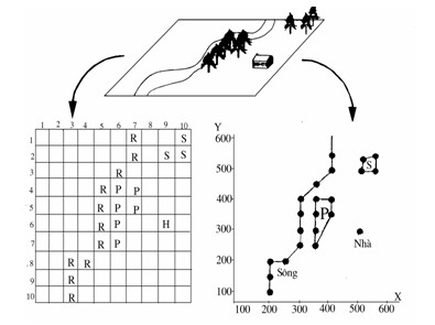
Figure 1.2: Real world on two GIS raster (a) and vector (b) models
a. Vector System
Mathematically, a vector is a line segment with a direction and a fixed length. A point is a vector of zero length. In the GIS vector data model, the location of a spatial object is recorded precisely by x, y coordinates in a coordinate reference system with the coordinate system used for the Earth.
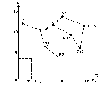
Figure 1.3: Representing the positions of three spatial objects in the UTM coordinate system
In the vector model, people abstract phenomena and call them features. Features are represented by geometric objects: point, line, polygon. These representations apply to single objects with specific shapes and contours.
Figure 1.4: Map with vector data model In this representation, we define:
A feature is an object on the map that has a defined shape and location, and has specific properties and behaviors.
Feature Class is a set of features of the same type, i.e. a set of points, lines, or polygons. Feature classes are equivalent to a layer on a map.
Feature Dataset is a set of feature classes or a set of layers on the same coordinate system. Feature dataset is equivalent to a map.
Data Elements In a feature dataset, each point is stored under a single coordinate, a line is stored as a series of points with given x, y coordinates, and a polygon is stored as a set of points with x, y coordinates that define closed straight lines.
*Points object type
Points are identified by value pairs. Single geographic information objects that contain only location information will be reflected as point objects. Point type objects have the following characteristics:
- Is a single coordinate (x,y)
- No need to show length and area
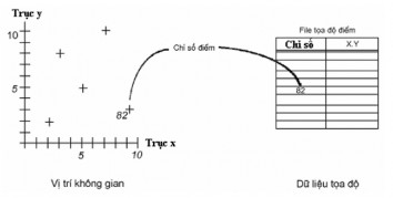
Figure 1.5: Vector data is represented as points (Point)
On a large-scale map, an object is represented as an area. However, on a small-scale map, this object can be represented as a point. Therefore, point and area objects can be used to reflect each other.
*Line object type (Arcs)
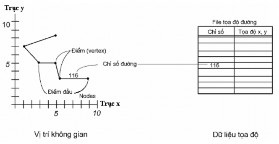
Figure 1.6: Vector data represented in Arc form
A line is defined as a sequence of points. It describes linear geographic features, with the following characteristics:
- Is a series of coordinate pairs
- An arc starts and ends with a node
- Arcs are connected and intersect at nodes
- The shape of the arc is defined by vertices
- Exact length by coordinate pairs
Polygons object type
Areas are defined by straight line boundaries. Geographical features that have an area and are enclosed by a line are called polygons, which have the following characteristics:
- Polygons are described by a set of arcs and label points.
- One or more arcs defining the contour of the region
- A label point is located in the region to describe and identify each region.
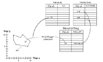
Figure 1.7: Vector data represented as a polygon
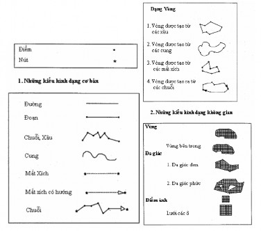
Figure 1.8: Some concepts in the map database structure
Additionally, vector GIS has two data models: topology vector data and spaghetti vector data.
* Advantages and disadvantages of vector data model:
The advantages of vector data can be listed as: