In terms of maritime geography, there is no better and more convenient seaport in Vietnam than Van Phong port to build an international transit port. With a 400m wide sea channel, a depth of 22 - 27m, many sections with a depth of 41m, located in a sheltered bay, the bay shore is 30.7km long, which can build ports, warehouses, and container yards. In addition, the bay's water surface is an ideal place for fuel tankers with a tonnage of up to 250,000 DWT to safely transport fuel. It is estimated that if 20 million tons are approved each year, the state budget will collect over 10,000 billion VND.
Van Phong International Terminal will include 3 important areas: First , Dam Mon wharf area for international container transit, serving mainly large and very large ships with a capacity of 9,000 TEU or more. This is a hub for import and export goods by container operating on transoceanic routes of Vietnam and neighboring countries in the region. Second , Van Phong Bay South wharf area (receiving ships with a capacity of 400,000 DWT) for crude oil and oil product transit, with a bonded warehouse in Hon My Giang, combined with a specialized wharf for the oil refinery to be built here. Third , is a specialized wharf area for thermal power plants, shipbuilding and repair, other industries receiving ships of 50,000 - 100,000 DWT and a satellite local wharf for ships of 2 - 10,000 DWT in the Southwest of Van Phong Bay (Ninh Thuy - Doc Let - Hon Khoi).
The idea of building Van Phong into an international transit port was proposed in the early 1990s. However, it was not until 2005 that it was officially approved and in October 2008 the project was handed over to Vietnam National Shipping Lines (Vinalines) for implementation.
In October 2009, Vinaline started construction of phase 1 including 2 wharves.
6,000 TEU and 9,000 TEU. After 2 years of construction, the project had only driven 145/1729 piles when it encountered a geological problem and had to stop construction. Furthermore, due to the rapid progress of science and technology, ships with a capacity of up to 14,000 TEU - 18,000 TEU have appeared, so the design of the 6,000 TEU and 9,000 TEU piers is no longer suitable, forcing the port to stop construction to change the design. Vinaline has proposed to the Government to adjust the design to receive ships of 12,000 TEU and 15,000 TEU. Currently, the new designer is conducting a survey and redoing the project and it is expected that when the project restarts, there will be cooperation between Vinaline and the Rotterdam Port Corporation (Netherlands) in the construction of Van Phong port.
Thus, the delay in the construction of Van Phong port (phase 1) is due to 3 main reasons: due to geological problems, due to lack of capital because this phase requires 185 million USD and Vinaline has to balance it by itself, due to lack of vision right from the start of the design. The delay in Van Phong port not only causes economic losses but also the opportunity for Van Phong to compete with other transit ports in the region will gradually be limited.
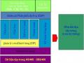
2.3.3. Current status of investment in seaport development - considered by investment content
Investment activities in seaport development, if considered in terms of investment content, include investment in the construction of wharves, breakwaters, etc., investment in equipment for loading and unloading goods at the port, and investment in human resource development. Investment costs for each of the above contents are very different, depending on the needs of each seaport project, depending on the geographical location, natural conditions, scale, and nature of each port (refer to appendix 2.1, 2.2, 2.3), but usually fluctuate within the following range:
1.5%
2.0%
18.0%
26.5%
52.0%
Construction of protective works (reves, breakwaters...) and dredging of the port channel Construction of port access roads
Construction of port bridges and electrical, water, cooling equipment... Cargo handling equipment
Human resources
Chart 2.1: Investment capital for seaports by investment category, period 2005 - 2011
Source: Calculated based on data from the Department of Infrastructure and Urban Structure - Ministry of Planning and Investment, Department of Transport Infrastructure - Ministry of Transport and records of seaport projects.
2.3.3.1. Construction investment
a. Investment in construction of port infrastructure
Investment in port infrastructure can be carried out by the state or port enterprises.
- Investing in wharves
Most of Vietnam's seaports today have a port structure of gravity type, steel sheet pile wall or high pile base. The surface load of the wharf is usually from 2 to 10 tons/m2 . Some wharves are of the type of shore-mounted wharf or caisson. The process of building wharfs has applied the world's advanced seaport construction technology. The port construction model is quite diverse: there are traditional ports; there are sea-encroaching ports (such as Dinh Vu port, Lach Huyen - Hai Phong...); there are ports dug deep into the mainland (such as My Thuy port - Quang Tri). Depending on natural conditions, investors will choose a suitable port construction model that still ensures functionality with low cost.
Reasonable construction and operating costs.
Due to the technical complexity, the construction of wharf projects often involves the participation of many international and domestic consultants and construction contractors. For example, when implementing the 5B package to build 6 export wharfs of Dung Quat port, the design part was undertaken by Tedi South - Portcoast, the construction part was undertaken by Cienco 6, Cienco 1, PTSC and foreign subcontractors from Singapore, Malaysia... [38].
In fact, investment in the construction of ports and wharves in Vietnam is very flexible, many port projects are even ahead of planning to anticipate the requirements of the world transport market. Many port projects have applied for and been approved to design wharves capable of receiving ships with a tonnage larger than the planned size, such as Gemadept Terminal Link port designed for ships with a tonnage of up to 200,000 DWT, CMIT, SSIT wharves... designed for ships with a tonnage of up to 160,000 DWT while the planning is only 100,000 DWT. It is also thanks to this flexibility that Cai Mep port cluster
- Thi Vai is planned to be an international gateway port, but for the past 2 years it has been operating as an international container transit port.
- Investing in warehouse systems in the port
Most ports have warehouse systems to store and classify goods at the port. However, as the volume of goods passing through the port has increased rapidly in recent years, the warehouse systems at many ports have not been able to meet the demand. For example, at Vietnam Maritime Corporation, the warehouse area of its member units is 411 hectares [84]. Compared to Shenzhen Port (China) with a similar wharf length, they have a much larger warehouse area of 590 hectares [12].
The biggest difficulty that investors encounter when building a warehouse system
In the port, the majority of Vietnamese seaports have very narrow rear areas. Especially the main ports are often limited by narrow urban areas, land area for warehouses and port development is limited, there is no land fund for further construction or modernization. This has led to the backwardness of the Vietnamese seaport warehouse system.
To overcome the above situation, when the rear land fund is no longer available for expansion, ports can only develop towards the sea (such as Dinh Vu port, Lach Huyen - Hai Phong), or rent warehouses outside (such as Chua Ve Hai Phong container port), or open more ICD ports (such as Saigon port...), or rationalize loading and unloading technology to make the most of the existing warehouse area. The last measure that can be mentioned is to move the port to another location with a more spacious and convenient area.
- Investing in port infrastructure systems
The port infrastructure system is first of all the transport network in the port, electricity, water, communications..., then the commercial - financial services, banking and other social infrastructure associated with the port. In general, if Vietnamese seaports are located near urban centers, the electricity and water systems are good and meet the requirements. However, when the ports are concentrated in the same area (such as Cai Mep Thi Vai port cluster - Ba Ria Vung Tau) or the ports are located far from the urban center, the power shortage still occurs, affecting the operation of the port, the operation of the warehouse for storing goods and cold containers, forcing investors to spend up to 50 - 60 million USD for a generator serving the port, which is very expensive. Meanwhile, the commercial - financial services in most Vietnamese seaports are currently very weak.
b. Investment in construction of public infrastructure of seaports
In addition to serving the public and maintaining the development of the seaport system, public port infrastructure also serves to ensure security and national defense, so investment is entirely from the state budget and ODA capital.
If considering each item separately, the infrastructure outside the port can be divided into maritime traffic systems and maritime safety assurance.
- Regarding Maritime Safety Assurance : Including the lighthouse system, signal beacons... are entirely invested and managed by "Maritime Safety Assurance" - under the Vietnam Maritime Administration - which is the unit that directly invests and manages the exploitation process. This unit is a member of the International Association of Lighthouse Associations (IALA).
Up to now, Vietnam's lighthouse system has 92 lights, some of which are
built during the French period, the rest were mostly built from the 1960s onwards with 49 lights arranged based on 3,260 km of coastline, 32 lights arranged on islands near and far from shore; 11 lights arranged on Truong Sa archipelago. The equipment of the lights, due to being invested in many periods, has many different types, causing difficulties and complications for management, operation and repair.
The signal system to control the navigation into the seaports is relatively modern, meeting international standards with 775 maritime signals operating well. However, the installation of Rancom equipment (a device that reflects radar beams) on buoy No. 0 to support ships entering the channel more accurately and quickly has been recommended for quite a long time but has not yet been invested in.
- For maritime traffic system:According to current regulations, the maritime traffic system is divided into two types: public maritime traffic and specialized maritime traffic.
Public waterways are used for public purposes and are directly managed by the Vietnam Maritime Safety Authority. Investment in construction, maintenance and dredging of waterways is carried out according to state orders or through bidding. Investment in construction of waterways is funded by the state budget, while funding for restoration of public waterways is used from maritime safety fee revenue.
Dedicated waterways, also known as seaport branch waterways, are used exclusively for one port and are invested in, built and managed by that port enterprise. The investment capital for waterway development can be greatly supported by the state. The budget for maintenance of dedicated waterways is deducted according to a percentage from the Maritime Safety Assurance fee - the percentage is decided by the state.
Most of Vietnam's seaports are built on the shore or river mouths, so they are greatly affected by tides and sedimentation, so the channels are long and the depth is limited, especially ports in the North and South. To ensure the design depth, every year the entire channel system into Vietnam's ports must be dredged about 6.5 million m3 of sedimented sand and mud, with a budget of tens of thousands of billions of VND. However, due to limited funding, only about 50% of the volume required for dredging can be done every year. For example, in the case of Hai Phong port, to maintain the channel depth into the port at -7.2m,
Every year the state budget needs to spend about 200 billion VND to dredge sediment.
(once every 3 months). However, due to insufficient budget funds, the depth of the channel into Hai Phong port is not maintained stably. In many cases, ships entering Hai Phong port have to reduce their load, causing businesses to incur additional costs. The increased costs have caused some large tonnage ships to leave Hai Phong port, causing the state to lose revenue.
The shipping channel is narrow, the depth is limited, while the tonnage of ships going to/from the port is increasing, so ensuring the shipping channel is a challenge for the Vietnamese maritime industry. Therefore, in addition to the annual dredging costs, in recent years the Government has invested in many projects to develop public shipping channels as shown in Table 2.9.
Table 2.9: Committed/ongoing maritime channel development projects (as of 2011)
STT
Project | Total investment private | Agency perform | Capital | |
1 | Renovating shipping channel for Cam Pha port (Quang Ninh) | 7 million USD | Department of Natural Resources and Environment Vietnam | Government Vietnam |
2 | Upgrading the shipping channel for Dinh Vu wharf (Hai Phong port) | - | Department of Natural Resources and Environment Vietnam | Government Vietnam |
3 | Upgrading shipping channel for Nghi Son port | 4 million USD | Department of Natural Resources and Environment Vietnam | Government Vietnam |
4 | Upgrading shipping channels for Cua Lo seaport | 4 million USD | Department of Natural Resources and Environment Vietnam | Government Vietnam |
5 | Upgrading the shipping channel into Cua port Vietnamese (Quang Tri) | 221 billion VND | Department of Natural Resources and Environment Vietnam | Government Vietnam |
6 | Upgrading the shipping channel into the general port Dung Quat complex | 70,141 billion VND | Department of Natural Resources and Environment Vietnam | Government Vietnam |
7 | Renovating the shipping channel into Quy Nhon port | 4 million USD | Department of Natural Resources and Environment Vietnam | Government Vietnam |
8 | Upgrading the flow for the wharves in Cai area Mep - Thi Vai at Vung Tau seaport | 16 million USD | Department of Natural Resources and Environment Vietnam | Government Vietnam |
9 | Upgrading Soai Rap canal - port access channel Hiep Phuoc (Ho Chi Minh City) | 33 million USD | Department of Natural Resources and Environment Vietnam | Government Vietnam |
10 | Quan Chanh Bo Canal Development Project | 198 million USD | Department of Natural Resources and Environment Vietnam | Government Vietnam |
11 | Dredging Bo De channel for exploitation Nam Can Port Waterfall (Ca Mau) | 193.9 billion VND | Department of Natural Resources and Environment Vietnam | Government Vietnam |
Maybe you are interested!
-
 Current Status of Customer Relationship Management at Vietnam Joint Stock Commercial Bank for Investment and Development - Ha Long Branch
 -
 Current Status of Management of Economic Development Investment Activities
 -
 Current Status of Investment and Development of Vietnam's Seaports
 -
 Identify Rating Levels and Rating Scales
zt2i3t4l5ee
zt2a3gstourism,quan lan,quang ninh,ecology,ecotourism,minh chau,van don,geography,geographical basis,tourism development,science
zt2a3ge
zc2o3n4t5e6n7ts
of the islanders. Therefore, this indicator will be divided into two sub-indicators:
a1. Natural tourism attractiveness a2. Cultural tourism attractiveness
b. Tourist capacity
The two island communes in Quan Lan have different capacities to receive tourists. Minh Chau Commune is home to many standard hotels and resorts, attracting high-income domestic and international tourists. Meanwhile, Quan Lan Commune has many motels mainly built and operated by local people, so the scale and quality are not high, and will be suitable for ordinary tourists such as students.
c. Time of exploitation of Quan Lan Island Commune:
Quan Lan tourism is seasonal due to weather and climate conditions and festivals only take place on certain days of the year, specifically in spring. In Quan Lan commune, the period from April to June and from September to November is considered the best time to visit Quan Lan because the cultural tourism activities are mainly associated with festivals taking place during this time.
Minh Chau island commune:
Tourism exploitation time is all year round, because this is a place with a number of tourist attractions with diverse ecosystems such as Bai Tu Long National Park Research Center, Tram forest, Turtle Laying Beach, so besides coming to the beach for tourism and vacation in the summer, Minh Chau will attract research groups to come for tourism combined with research at other times of the year.
d. Sustainability
The sustainability of ecotourism sites in Quan Lan and Minh Chau communes depends on the sensitivity of the ecosystems to climate changes.
landscape. In general, these tourist destinations have a fairly high level of sustainability, because they are natural ecosystems, planned and protected. However, if a large number of tourists gather at certain times, it can exceed the carrying capacity and affect the sustainability of the environment (polluted beaches, damaged trees, animals moving away from their habitats, etc.), then the sustainability of the above ecosystems (natural ecosystems, human ecosystems) will also be affected and become less sustainable.
e. Location and accessibility
Both island communes have ports to take tourists to visit from Van Don wharf:
- Quan Lan – Van Don traffic route:
Phuc Thinh – Viet Anh high-speed boat and Quang Minh high-speed boat, depart at 8am and 2pm from Van Don to Quan Lan, and at 7am and 1pm from Quan Lan to Van Don. There are also wooden boats departing at 7am and 1pm.
- Van Don - Minh Chau traffic route:
Chung Huong high-speed train, Minh Chau train, morning 7:30 and afternoon 13:30 from Van Don to Minh Chau, morning 6:30 and afternoon 13:00 from Minh Chau to Van Don.
f. Infrastructure
Despite receiving investment attention, the issue of infrastructure and technical facilities for tourism on Quan Lan Island is still an issue that needs to be resolved because it has a direct impact on the implementation of ecotourism activities. The minimum conditions for serving tourists such as accommodation, electricity, water, communication, especially medical services, and security work need to be given top priority. Ecotourism spots in Minh Chau commune are assessed to have better infrastructure and technical facilities for tourism because there are quite complete and synchronous conditions for serving tourists, meeting many needs of domestic and foreign tourists.
3.2.1.4. Determine assessment levels and assessment scales
Corresponding to the levels of each criterion, the index is the score of those levels in the order of 4, 3, 2, 1 decreasing according to the standard of each level: very attractive (4), attractive (3), average (2), less attractive (1).
3.2.1.5. Determining the coefficients of the criteria
For the assessment of DLST in the two communes of Quan Lan and Minh Chau islands, the students added evaluation coefficients to show the importance of the criteria and indicators as follows:
Coefficient 3 with criteria: Attractiveness, Exploitation time. These are the 2 most important criteria for attracting tourists to tourism in general and eco-tourism in particular, so they have the highest coefficient.
Coefficient 2 with criteria: Capacity, Infrastructure, Location and accessibility . Because the assessment area is an island commune of Van Don district, the above criteria are selected by the author with appropriate coefficients at the average level.
Coefficient 1 with criteria: Sustainability. Quan Lan has natural and human-made ecotourism sites, with high biodiversity and little impact from local human factors. Most of the ecotourism sites are still wild, so they are highly sustainable.
3.2.1.6. Results of DLST assessment on Quan Lan island
a. Assessment of the potential for natural tourism development
For Minh Chau commune:
+ Natural tourism attractiveness is determined to be very attractive (4 points) and the most important coefficient (coefficient 3), so the score of the Attractiveness criterion is 4 x 3 = 12.
+ Capacity is determined as average (2 points) and the coefficient is quite important (coefficient 2), then the score of Capacity criterion is 2 x 2 = 4.
+ Exploitation time is long (4 points), the most important coefficient (coefficient 3) so the score of the Exploitation time criterion is 4 x 3 = 12.
+ Sustainability is determined as sustainable (4 points), the important coefficient is the average coefficient (coefficient 1), so the score of the Sustainability criterion is 4 x 1 = 4 points
+ Location and accessibility are determined to be quite favorable (2 points), the coefficient is quite important (coefficient 2), the criterion score is 2 x 2 = 4 points.
+ Infrastructure is assessed as good (3 points), the coefficient is quite important (coefficient 2), then the score of the Infrastructure criterion is 3 x 2 = 6 points.
The total score for evaluating DLST in Minh Chau commune according to 6 evaluation criteria is determined as: 12 + 4 + 12 + 4 + 4 + 6 = 42 points
Similar assessment for Quan Lan commune, we have the following table:
Table 3.3: Assessment of the potential for natural ecotourism development in Quan Lan and Minh Chau communes
Attractiveness of self-tourismof course
Capacity
Mining time
Sustainability
Location and accessibility
Infrastructure
Result
Point
DarkMulti
Point
DarkMulti
Point
DarkMulti
Point
DarkMulti
Point
DarkMulti
Point
DarkMulti
CommuneMinh Chau
12
12
4
8
12
12
4
4
4
8
6
8
42/52
Quan CommuneLan
6
12
6
8
9
12
4
4
4
8
4
8
33/52
b. Assessment of the potential for humanistic tourism development
For Quan Lan commune:
+ The attractiveness of human tourism is determined to be very attractive (4 points) and the most important coefficient (coefficient 3), so the score of the Attractiveness criterion is 4 x 3 = 12.
+ Capacity is determined to be large (3 points) and the coefficient is quite important (coefficient 2), then the score of the Capacity criterion is 3 x 2 = 6.
+ Mining time is average (3 points), the most important coefficient (coefficient 3) so the score of the Mining time criterion is 3 x 3 = 9.
+ Sustainability is determined as sustainable (4 points), the important coefficient is the average coefficient (coefficient 1), so the score of the Sustainability criterion is 4 x 1 = 4 points.
+ Location and accessibility are determined to be quite favorable (2 points), the coefficient is quite important (coefficient 2), the criterion score is 2 x 2 = 4 points.
+ Infrastructure is rated as average (2 points), the coefficient is quite important (coefficient 2), then the score of the Infrastructure criterion is 2 x 2 = 4 points.
The total score for evaluating DLST in Quan Lan commune according to 6 evaluation criteria is determined as: 12 + 6 + 6 + 4 + 4 + 4 = 36 points.
Similar assessment with Minh Chau commune we have the following table:
Table 3.4: Assessment of the potential for developing humanistic eco-tourism in Quan Lan and Minh Chau communes
Attractiveness of human tourismliterature
Capacity
Mining time
Sustainability
Location and accessibility
Infrastructure
Result
Point
DarkMulti
Point
DarkMulti
Point
DarkMulti
Point
DarkMulti
Point
DarkMulti
Point
DarkMulti
Quan CommuneLan
12
12
6
8
9
12
4
4
4
8
4
8
39/52
Minh CommuneChau
6
12
4
8
12
12
4
4
4
8
6
8
36/52
Basically, both Minh Chau and Quan Lan localities have quite favorable conditions for developing ecotourism. However, Quan Lan commune has more advantages to develop ecotourism in a humanistic direction, because this is an area with many famous historical relics such as Quan Lan Communal House, Quan Lan Pagoda, Temple worshiping the hero Tran Khanh Du, ... along with local festivals held annually such as the wind praying ceremony (March 15), Quan Lan festival (June 10-19); due to its location near the port and long exploitation time, the beaches in Quan Lan commune (especially Quan Lan beach) are no longer hygienic and clean to ensure the needs of tourists coming to relax and swim; this is also an area with many beautiful landscapes such as Got Beo wind pass, Ong Phong head, Voi Voi cave, but the ability to access these places is still very limited (dirt hill road, lots of gravel and rocks), especially during rainy and windy times; In addition, other natural resources such as mangrove forests and sea worms have not been really exploited for tourism purposes and ecotourism development. On the contrary, Minh Chau commune has more advantages in developing ecotourism in the direction of natural tourism, this is an area with diverse ecosystems such as at Rua De Beach, Bai Tu Long National Park Conservation Center...; Minh Chau beach is highly appreciated for its natural beauty and cleanliness, ranked in the top ten most beautiful beaches in Vietnam; Minh Chau commune is also home to Tram forest with a large area and a purity of up to 90%, suitable for building bridges through the forest (a very effective type of natural ecotourism currently applied by many countries) for tourists to sightsee, as well as for the purpose of studying and researching.
Figure 3.1: Thenmala Forest Bridge (India) Source: https://www.thenmalaecotourism.com/(August 21, 2019)
3.2.2. Using SWOT matrix to evaluate Quan Lan island tourism
General assessment of current tourism activities of Quan Lan island is shown through the following SWOT matrix:
Table 3.5: SWOT matrix evaluating tourism activities on Quan Lan island
Internal agent
Strengths- There is a lot of potential for tourism development, especially natural ecotourism and humanistic ecotourism.- The unskilled labor force is relatively abundant.- resource environmentunpolluted, still
Weaknesses- Poorly developed infrastructure, especially traffic routes to tourist destinations on the island.- The team of professional staff is still weak.- Tourism products in general
quite wild, originalintact
general and DLST in particularalone is monotonous.
External agents
Opportunity- Tourism is a key industry in the socio-economic development strategy of the province and Van Don economic zone.- Quan Lan was selected as a pilot area for eco-tourism development within the framework of the green growth project between Quang Ninh province and the Japanese organization JICA.- The flow of tourists and especially ecotourism in the world tends toincreasing
Challenge- Weather and climate change abnormally.- Competition in tourism products is increasingly fierce, especially with other localities in the province such as Ha Long, Mong Cai...- Awareness of tourists, especially domestic tourists, about ecotourism and nature conservation is not high.
Through summary analysis using SWOT matrix we see that:
To exploit strengths and take advantage of opportunities, it is necessary to:
- Diversify products and service types (build more tourism routes aimed at specific needs of tourists: experiential tourism immersed in nature, spiritual cultural tourism...)
- Effective exploitation of resources and differentiated products (natural resources and human resources)
div.maincontent .p { color: black; font-family:"Times New Roman", serif; font-style: normal; font-weight: normal; text-decoration: none; font-size: 14pt; margin:0pt; } div.maincontent p { color: black; font-family:"Times New Roman", serif; font-style: normal; font-weight: normal; text-decoration: none; font-size: 14pt; margin:0pt; } div.maincontent .s1 { color: black; font-family:"Times New Roman", serif; font-style: normal; font-weight: normal; text-decoration: none; font-size: 13pt; } div.maincontent .s2 { color: black; font-family:"Times New Roman", serif; font-style: normal; font-weight: normal; text-decoration: none; font-size: 13pt; } div.maincontent .s3 { color: #0D0D0D; font-family:"Times New Roman", serif; font-style: normal; font-weight: bold; text-decoration: none; font-size: 14pt; } div.maincontent .s4 { color: black; font-family:"Times New Roman", serif; font-style: italic; font-weight: normal; text-decoration: none; font-size: 14pt; } div.maincontent .s5 { color: black; font-family:"Times New Roman", serif; font-style: italic; font-weight: bold; text-decoration: none; font-size: 14pt; } div.maincontent .s6 { color: black; font-family:"Times New Roman", serif; font-style: italic; font-weight: normal; text-decoration: none; font-size: 14pt; vertical-align: -3pt; } div.maincontent .s7 { color: black; font-family:"Times New Roman", serif; font-style: italic; font-weight: normal; text-decoration: none; font-size: 14pt; vertical-align: -2pt; } div.maincontent .s8 { color: black; font-family:"Times New Roman", serif; font-style: italic; font-weight: normal; text-decoration: none; font-size: 14pt; vertical-align: -1pt; } div.maincontent .s9 { color: black; font-family:"Times New Roman", serif; font-style: normal; font-weight: normal; text-decoration: none; font-size: 14pt; } div.maincontent .s10 { color: black; font-family:"Times New Roman", serif; font-style: normal; font-weight: bold; text-decoration: none; font-size: 14pt; } div.maincontent .s11 { color: black; font-family:"Times New Roman", serif; font-style: normal; font-weight: normal; text-decoration: none; font-size: 14pt; } div.maincontent .s12 { color: black; font-family:Symbol, serif; font-style: normal; font-weight: normal; text-decoration: none; font-size: 14pt; } div.maincontent .s13 { color: black; font-family:Wingdings; font-style: normal; font-weight: normal; text-decoration: none; font-size: 14pt; } div.maincontent .s14 { color: black; font-family:"Times New Roman", serif; font-style: normal; font-weight: normal; text-decoration: none; font-size: 9pt; vertical-align: 5pt; } div.maincontent .s15 { color: black; font-family:"Times New Roman", serif; font-style: normal; font-weight: normal; text-decoration: none; font-size: 9pt; vertical-align: 5pt; } div.maincontent .s16 { color: black; font-family:Cambria, serif; font-style: italic; font-weight: normal; text-decoration: none; font-size: 14pt; } div.maincontent .s17 { color: #080808; font-family:"Times New Roman", serif; font-style: normal; font-weight: bold; text-decoration: none; font-size: 14pt; } div.maincontent .s18 { color: #080808; font-family:"Times New Roman", serif; font-style: normal; font-weight: normal; text-decoration: none; font-size: 14pt; } div.maincontent .s19 { color: black; font-family:"Times New Roman", serif; font-style: normal; font-weight: normal; text-decoration: none; font-size: 11pt; } div.maincontent .s20 { color: black; font-family:"Times New Roman", serif; font-style: normal; font-weight: normal; text-decoration: none; font-size: 10pt; } div.maincontent .s21 { color: black; font-family:"Times New Roman", serif; font-style: normal; font-weight: bold; text-decoration: none; font-size: 11pt; } div.maincontent .s22 { color: black; font-family:"Times New Roman", serif; font-style: normal; font-weight: normal; text-decoration: none; font-size: 11pt; } div.maincontent .s23 { color: black; font-family:"Times New Roman", serif; font-style: italic; font-weight: normal; text-decoration: none; font-size: 14pt; } div.maincontent .s24 { color: #212121; font-family:"Times New Roman", serif; font-style: normal; font-weight: normal; tex
Identify Rating Levels and Rating Scales
zt2i3t4l5ee
zt2a3gstourism,quan lan,quang ninh,ecology,ecotourism,minh chau,van don,geography,geographical basis,tourism development,science
zt2a3ge
zc2o3n4t5e6n7ts
of the islanders. Therefore, this indicator will be divided into two sub-indicators:
a1. Natural tourism attractiveness a2. Cultural tourism attractiveness
b. Tourist capacity
The two island communes in Quan Lan have different capacities to receive tourists. Minh Chau Commune is home to many standard hotels and resorts, attracting high-income domestic and international tourists. Meanwhile, Quan Lan Commune has many motels mainly built and operated by local people, so the scale and quality are not high, and will be suitable for ordinary tourists such as students.
c. Time of exploitation of Quan Lan Island Commune:
Quan Lan tourism is seasonal due to weather and climate conditions and festivals only take place on certain days of the year, specifically in spring. In Quan Lan commune, the period from April to June and from September to November is considered the best time to visit Quan Lan because the cultural tourism activities are mainly associated with festivals taking place during this time.
Minh Chau island commune:
Tourism exploitation time is all year round, because this is a place with a number of tourist attractions with diverse ecosystems such as Bai Tu Long National Park Research Center, Tram forest, Turtle Laying Beach, so besides coming to the beach for tourism and vacation in the summer, Minh Chau will attract research groups to come for tourism combined with research at other times of the year.
d. Sustainability
The sustainability of ecotourism sites in Quan Lan and Minh Chau communes depends on the sensitivity of the ecosystems to climate changes.
landscape. In general, these tourist destinations have a fairly high level of sustainability, because they are natural ecosystems, planned and protected. However, if a large number of tourists gather at certain times, it can exceed the carrying capacity and affect the sustainability of the environment (polluted beaches, damaged trees, animals moving away from their habitats, etc.), then the sustainability of the above ecosystems (natural ecosystems, human ecosystems) will also be affected and become less sustainable.
e. Location and accessibility
Both island communes have ports to take tourists to visit from Van Don wharf:
- Quan Lan – Van Don traffic route:
Phuc Thinh – Viet Anh high-speed boat and Quang Minh high-speed boat, depart at 8am and 2pm from Van Don to Quan Lan, and at 7am and 1pm from Quan Lan to Van Don. There are also wooden boats departing at 7am and 1pm.
- Van Don - Minh Chau traffic route:
Chung Huong high-speed train, Minh Chau train, morning 7:30 and afternoon 13:30 from Van Don to Minh Chau, morning 6:30 and afternoon 13:00 from Minh Chau to Van Don.
f. Infrastructure
Despite receiving investment attention, the issue of infrastructure and technical facilities for tourism on Quan Lan Island is still an issue that needs to be resolved because it has a direct impact on the implementation of ecotourism activities. The minimum conditions for serving tourists such as accommodation, electricity, water, communication, especially medical services, and security work need to be given top priority. Ecotourism spots in Minh Chau commune are assessed to have better infrastructure and technical facilities for tourism because there are quite complete and synchronous conditions for serving tourists, meeting many needs of domestic and foreign tourists.
3.2.1.4. Determine assessment levels and assessment scales
Corresponding to the levels of each criterion, the index is the score of those levels in the order of 4, 3, 2, 1 decreasing according to the standard of each level: very attractive (4), attractive (3), average (2), less attractive (1).
3.2.1.5. Determining the coefficients of the criteria
For the assessment of DLST in the two communes of Quan Lan and Minh Chau islands, the students added evaluation coefficients to show the importance of the criteria and indicators as follows:
Coefficient 3 with criteria: Attractiveness, Exploitation time. These are the 2 most important criteria for attracting tourists to tourism in general and eco-tourism in particular, so they have the highest coefficient.
Coefficient 2 with criteria: Capacity, Infrastructure, Location and accessibility . Because the assessment area is an island commune of Van Don district, the above criteria are selected by the author with appropriate coefficients at the average level.
Coefficient 1 with criteria: Sustainability. Quan Lan has natural and human-made ecotourism sites, with high biodiversity and little impact from local human factors. Most of the ecotourism sites are still wild, so they are highly sustainable.
3.2.1.6. Results of DLST assessment on Quan Lan island
a. Assessment of the potential for natural tourism development
For Minh Chau commune:
+ Natural tourism attractiveness is determined to be very attractive (4 points) and the most important coefficient (coefficient 3), so the score of the Attractiveness criterion is 4 x 3 = 12.
+ Capacity is determined as average (2 points) and the coefficient is quite important (coefficient 2), then the score of Capacity criterion is 2 x 2 = 4.
+ Exploitation time is long (4 points), the most important coefficient (coefficient 3) so the score of the Exploitation time criterion is 4 x 3 = 12.
+ Sustainability is determined as sustainable (4 points), the important coefficient is the average coefficient (coefficient 1), so the score of the Sustainability criterion is 4 x 1 = 4 points
+ Location and accessibility are determined to be quite favorable (2 points), the coefficient is quite important (coefficient 2), the criterion score is 2 x 2 = 4 points.
+ Infrastructure is assessed as good (3 points), the coefficient is quite important (coefficient 2), then the score of the Infrastructure criterion is 3 x 2 = 6 points.
The total score for evaluating DLST in Minh Chau commune according to 6 evaluation criteria is determined as: 12 + 4 + 12 + 4 + 4 + 6 = 42 points
Similar assessment for Quan Lan commune, we have the following table:
Table 3.3: Assessment of the potential for natural ecotourism development in Quan Lan and Minh Chau communes
Attractiveness of self-tourismof course
Capacity
Mining time
Sustainability
Location and accessibility
Infrastructure
Result
Point
DarkMulti
Point
DarkMulti
Point
DarkMulti
Point
DarkMulti
Point
DarkMulti
Point
DarkMulti
CommuneMinh Chau
12
12
4
8
12
12
4
4
4
8
6
8
42/52
Quan CommuneLan
6
12
6
8
9
12
4
4
4
8
4
8
33/52
b. Assessment of the potential for humanistic tourism development
For Quan Lan commune:
+ The attractiveness of human tourism is determined to be very attractive (4 points) and the most important coefficient (coefficient 3), so the score of the Attractiveness criterion is 4 x 3 = 12.
+ Capacity is determined to be large (3 points) and the coefficient is quite important (coefficient 2), then the score of the Capacity criterion is 3 x 2 = 6.
+ Mining time is average (3 points), the most important coefficient (coefficient 3) so the score of the Mining time criterion is 3 x 3 = 9.
+ Sustainability is determined as sustainable (4 points), the important coefficient is the average coefficient (coefficient 1), so the score of the Sustainability criterion is 4 x 1 = 4 points.
+ Location and accessibility are determined to be quite favorable (2 points), the coefficient is quite important (coefficient 2), the criterion score is 2 x 2 = 4 points.
+ Infrastructure is rated as average (2 points), the coefficient is quite important (coefficient 2), then the score of the Infrastructure criterion is 2 x 2 = 4 points.
The total score for evaluating DLST in Quan Lan commune according to 6 evaluation criteria is determined as: 12 + 6 + 6 + 4 + 4 + 4 = 36 points.
Similar assessment with Minh Chau commune we have the following table:
Table 3.4: Assessment of the potential for developing humanistic eco-tourism in Quan Lan and Minh Chau communes
Attractiveness of human tourismliterature
Capacity
Mining time
Sustainability
Location and accessibility
Infrastructure
Result
Point
DarkMulti
Point
DarkMulti
Point
DarkMulti
Point
DarkMulti
Point
DarkMulti
Point
DarkMulti
Quan CommuneLan
12
12
6
8
9
12
4
4
4
8
4
8
39/52
Minh CommuneChau
6
12
4
8
12
12
4
4
4
8
6
8
36/52
Basically, both Minh Chau and Quan Lan localities have quite favorable conditions for developing ecotourism. However, Quan Lan commune has more advantages to develop ecotourism in a humanistic direction, because this is an area with many famous historical relics such as Quan Lan Communal House, Quan Lan Pagoda, Temple worshiping the hero Tran Khanh Du, ... along with local festivals held annually such as the wind praying ceremony (March 15), Quan Lan festival (June 10-19); due to its location near the port and long exploitation time, the beaches in Quan Lan commune (especially Quan Lan beach) are no longer hygienic and clean to ensure the needs of tourists coming to relax and swim; this is also an area with many beautiful landscapes such as Got Beo wind pass, Ong Phong head, Voi Voi cave, but the ability to access these places is still very limited (dirt hill road, lots of gravel and rocks), especially during rainy and windy times; In addition, other natural resources such as mangrove forests and sea worms have not been really exploited for tourism purposes and ecotourism development. On the contrary, Minh Chau commune has more advantages in developing ecotourism in the direction of natural tourism, this is an area with diverse ecosystems such as at Rua De Beach, Bai Tu Long National Park Conservation Center...; Minh Chau beach is highly appreciated for its natural beauty and cleanliness, ranked in the top ten most beautiful beaches in Vietnam; Minh Chau commune is also home to Tram forest with a large area and a purity of up to 90%, suitable for building bridges through the forest (a very effective type of natural ecotourism currently applied by many countries) for tourists to sightsee, as well as for the purpose of studying and researching.
Figure 3.1: Thenmala Forest Bridge (India) Source: https://www.thenmalaecotourism.com/(August 21, 2019)
3.2.2. Using SWOT matrix to evaluate Quan Lan island tourism
General assessment of current tourism activities of Quan Lan island is shown through the following SWOT matrix:
Table 3.5: SWOT matrix evaluating tourism activities on Quan Lan island
Internal agent
Strengths- There is a lot of potential for tourism development, especially natural ecotourism and humanistic ecotourism.- The unskilled labor force is relatively abundant.- resource environmentunpolluted, still
Weaknesses- Poorly developed infrastructure, especially traffic routes to tourist destinations on the island.- The team of professional staff is still weak.- Tourism products in general
quite wild, originalintact
general and DLST in particularalone is monotonous.
External agents
Opportunity- Tourism is a key industry in the socio-economic development strategy of the province and Van Don economic zone.- Quan Lan was selected as a pilot area for eco-tourism development within the framework of the green growth project between Quang Ninh province and the Japanese organization JICA.- The flow of tourists and especially ecotourism in the world tends toincreasing
Challenge- Weather and climate change abnormally.- Competition in tourism products is increasingly fierce, especially with other localities in the province such as Ha Long, Mong Cai...- Awareness of tourists, especially domestic tourists, about ecotourism and nature conservation is not high.
Through summary analysis using SWOT matrix we see that:
To exploit strengths and take advantage of opportunities, it is necessary to:
- Diversify products and service types (build more tourism routes aimed at specific needs of tourists: experiential tourism immersed in nature, spiritual cultural tourism...)
- Effective exploitation of resources and differentiated products (natural resources and human resources)
div.maincontent .p { color: black; font-family:"Times New Roman", serif; font-style: normal; font-weight: normal; text-decoration: none; font-size: 14pt; margin:0pt; } div.maincontent p { color: black; font-family:"Times New Roman", serif; font-style: normal; font-weight: normal; text-decoration: none; font-size: 14pt; margin:0pt; } div.maincontent .s1 { color: black; font-family:"Times New Roman", serif; font-style: normal; font-weight: normal; text-decoration: none; font-size: 13pt; } div.maincontent .s2 { color: black; font-family:"Times New Roman", serif; font-style: normal; font-weight: normal; text-decoration: none; font-size: 13pt; } div.maincontent .s3 { color: #0D0D0D; font-family:"Times New Roman", serif; font-style: normal; font-weight: bold; text-decoration: none; font-size: 14pt; } div.maincontent .s4 { color: black; font-family:"Times New Roman", serif; font-style: italic; font-weight: normal; text-decoration: none; font-size: 14pt; } div.maincontent .s5 { color: black; font-family:"Times New Roman", serif; font-style: italic; font-weight: bold; text-decoration: none; font-size: 14pt; } div.maincontent .s6 { color: black; font-family:"Times New Roman", serif; font-style: italic; font-weight: normal; text-decoration: none; font-size: 14pt; vertical-align: -3pt; } div.maincontent .s7 { color: black; font-family:"Times New Roman", serif; font-style: italic; font-weight: normal; text-decoration: none; font-size: 14pt; vertical-align: -2pt; } div.maincontent .s8 { color: black; font-family:"Times New Roman", serif; font-style: italic; font-weight: normal; text-decoration: none; font-size: 14pt; vertical-align: -1pt; } div.maincontent .s9 { color: black; font-family:"Times New Roman", serif; font-style: normal; font-weight: normal; text-decoration: none; font-size: 14pt; } div.maincontent .s10 { color: black; font-family:"Times New Roman", serif; font-style: normal; font-weight: bold; text-decoration: none; font-size: 14pt; } div.maincontent .s11 { color: black; font-family:"Times New Roman", serif; font-style: normal; font-weight: normal; text-decoration: none; font-size: 14pt; } div.maincontent .s12 { color: black; font-family:Symbol, serif; font-style: normal; font-weight: normal; text-decoration: none; font-size: 14pt; } div.maincontent .s13 { color: black; font-family:Wingdings; font-style: normal; font-weight: normal; text-decoration: none; font-size: 14pt; } div.maincontent .s14 { color: black; font-family:"Times New Roman", serif; font-style: normal; font-weight: normal; text-decoration: none; font-size: 9pt; vertical-align: 5pt; } div.maincontent .s15 { color: black; font-family:"Times New Roman", serif; font-style: normal; font-weight: normal; text-decoration: none; font-size: 9pt; vertical-align: 5pt; } div.maincontent .s16 { color: black; font-family:Cambria, serif; font-style: italic; font-weight: normal; text-decoration: none; font-size: 14pt; } div.maincontent .s17 { color: #080808; font-family:"Times New Roman", serif; font-style: normal; font-weight: bold; text-decoration: none; font-size: 14pt; } div.maincontent .s18 { color: #080808; font-family:"Times New Roman", serif; font-style: normal; font-weight: normal; text-decoration: none; font-size: 14pt; } div.maincontent .s19 { color: black; font-family:"Times New Roman", serif; font-style: normal; font-weight: normal; text-decoration: none; font-size: 11pt; } div.maincontent .s20 { color: black; font-family:"Times New Roman", serif; font-style: normal; font-weight: normal; text-decoration: none; font-size: 10pt; } div.maincontent .s21 { color: black; font-family:"Times New Roman", serif; font-style: normal; font-weight: bold; text-decoration: none; font-size: 11pt; } div.maincontent .s22 { color: black; font-family:"Times New Roman", serif; font-style: normal; font-weight: normal; text-decoration: none; font-size: 11pt; } div.maincontent .s23 { color: black; font-family:"Times New Roman", serif; font-style: italic; font-weight: normal; text-decoration: none; font-size: 14pt; } div.maincontent .s24 { color: #212121; font-family:"Times New Roman", serif; font-style: normal; font-weight: normal; tex -
 Credit risk at Bank for Investment and Development of Vietnam: Current situation and preventive solutions - 11
Source: Ministry of Transport and Report on overall investment monitoring and evaluation (first 6 months of 2011) of Vietnam Maritime Administration
c. Investing in the transportation system connecting to the port
In the past, Vietnam's seaport planning only considered the construction of wharves and investment in loading and unloading equipment, without paying much attention to the development of peripheral infrastructure such as road networks for cargo transportation, leading to many shortcomings and lack of uniformity in the transportation network connecting Vietnam's 200 ports with the rear. The reason for this situation is that the ports are licensed for construction by localities, but the connecting roads can be invested by the Central Government or by localities, while the budget for investing in roads is limited. Therefore, the investment projects in seaports and connecting roads are related to each other and do not match the implementation progress and the time of putting into operation. In chart 2.1, the ratio of 2% of the total investment capital for building roads to ports is only for building short sections of roads connecting existing local roads with the port.
- For road
Although most of Vietnam's seaports have a system of highways connecting to national roads, these routes often face traffic congestion. Some ports are located in urban and residential areas, so traffic is stagnant and can only operate at night, greatly limiting the productivity of the ports. Moreover, 4-lane highways are very rare. The road system in general (both road level and road gauge) and the urban traffic system connecting to ports in localities with large seaports such as Quang Ninh, Hai Phong, Ho Chi Minh City... are either degraded and cannot keep up with the rapid growth of goods traffic through seaports, or are slow to deploy, greatly affecting investment activities, construction and capacity development of seaports. In the Central region alone, the road system connecting the Central seaports with industrial parks, urban areas, and the Central Highlands is still very limited, with narrow road gauges and many bends that do not ensure container traffic.
Table 2.10: Road routes in need of upgrading or slow implementation
TT
Road name | Connecting line | Note | |
1 | Highway 18 | Quang Ninh - Hai Duong North Ninh | Overload |
2 | Dinh Vu Industrial Park Connection Route | Chua Ve - Nguyen Van intersection Linh - Dinh Vu Industrial Park | Overload |
3 | National Highway 19 | Quy Nhon Seaport - West Original | No guarantee |
4 | National Highway 20, 27 | Ba Ngoi Port - Lam Dong, Dak Nong | Many routes are not suitable for transportation. container transfer |
5 | National Highway 965 | QL 51 - Cai Mep Port - Town Fabric | Slow construction |
6 | Expressway | Ho Chi Minh City - Long Thanh - Vung Tau Ship | Slow construction |
7 | Inter-port route (Dong Nai) | Cat Lai Ferry - Ong Keo Industrial Park | No construction capital |
8 | Route connecting Dong Nai port with the national transport network | Bien Hoa 2 - Dong Nai port route | Not yet implemented due to lack of presence equal |
9 | Port connection route | Saigon Hiep Phuoc Port Project Phase 1 - Industrial Park Hiep Phuoc Industrial Park Phase 1 (including 1.5 km of road and 02 bridges) | Slow construction |
10 | Interprovincial Road 25B | Connecting to Cat Lai port | Delay due to absence by construction |
11 | Expressway connection | Cai Lan Port - Hai Phong Port | New construction |
Source: Department of Planning Management - Ministry of Planning and Investment [99]
- For railways
Although railway routes to ports are more convenient than roads, currently the only ports with direct railway access to the wharf are Hai Phong port at the main Hoang Dieu wharf warehouse. Even in the central seaports, the ports are located near the main cargo stations on the North-South railway line, but there are almost no branch lines connecting directly to the wharf, except for Ba Ngoi wharf (belonging to Nha Trang - Ba Ngoi port) with 3.2 km of railway, which is now degraded and unusable due to lack of maintenance and repair. This reality leads to goods being transported by rail having to use an additional step of using cars, thus increasing transportation costs and limiting transportation productivity. Currently, railways only meet about 10-15% of the demand for transporting goods through ports.
- Inland waterways
The inland waterway transport system in our country has many advantages for development.