a. Geographical location:
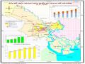
Cu Chi District has geographical coordinates from 10 0 53'00" to 10 0 10'00" North latitude and from 106 0 22'00" to 106 0 40'00" East longitude, located in the Northwest of Ho Chi Minh City, including 20 communes and one town with an area of 43,450.2 hectares, equal to 20.74% of the total area of the City. (Traffic and tourism map of Cu Chi District, Appendix 4)
· Bordering Tay Ninh province to the north.
· East borders Binh Duong province.
· South borders Hoc Mon district,
· West borders Long An province.
Cu Chi Town is the economic - political - cultural center of the district, 50km northwest of the city center on the Trans-Asia Highway. Cu Chi has a convenient geographical location and transportation system (both road and waterway), with potential resources, historical and cultural relics, high-tech agricultural production and fruit gardens, which are favorable for local tourism development as well as tourism linkage with neighboring provinces.
b. Topography and geomorphology:
The terrain of Cu Chi district is located in the transition zone between the Southwest and the Southeast, with the elevation gradually decreasing in the Northwest - Southeast and Northeast - Southwest directions. The average elevation above sea level is from 8m - 10m. In addition, the district has relatively many fields and land favorable for agricultural development compared to other districts in the City.
c. Climate :
Cu Chi district is located in a tropical monsoon climate zone, with equatorial characteristics. The climate is divided into two distinct seasons, the rainy season from May to November, the dry season from December to April of the following year, with the main characteristics being: Relatively stable temperature, high throughout the year and little change, the annual average is about 26.6 0 C. The highest monthly average temperature is 28.8 0 C (April), the lowest monthly average temperature is 24.8 0 C (December). However, the temperature range between day and night is quite large, in the dry season it is 8 0 - 10 0 C.
The average annual rainfall is from 1,300 mm - 1,770 mm, increasing gradually to the North according to the terrain height, the rain is unevenly distributed between the months of the year, the rain is concentrated in July, August, September; in December, January the rainfall is insignificant. The average annual air humidity is quite high at 79.5%, the highest in July, August, September is 80 - 90%, the lowest in December, January is 70%. The total average number of sunshine hours in the year is 2,100 - 2,920 hours.
The district is located in an area affected by the Southeast or South monsoon from February to May, the West - Southwest wind from May to September and the Northeast wind from October to February of the following year.
d. Hydrology:
Cu Chi district has a diverse system of rivers, canals and streams, with the main feature being that the Saigon River is subject to semi-diurnal tidal fluctuations, with the lowest average tidal level being 1.2 m and the highest being 2.0 m. Other natural canal systems are mostly directly affected by the hydrological regime of the Saigon River such as Rach Tra, Rach Son, Ben Muong... Only Thay Cai canal is affected by the hydrological regime of the Vam Co Dong River. In general, the system of rivers, canals and streams directly affects the hydrological regime of the district and the highlight is the flow and the impact of tides according to the semi-diurnal tidal regime. (Huynh Thi Loan Phuong, 2014).
4.1.1.3 Social conditions
Cu Chi's current population is estimated at over 411 thousand people, the administrative center is Cu Chi town, 50km from the city along the Trans-Asia Highway and 20 communes: Tan Phu Trung, Tan Thong Hoi, Tan An Hoi, Phuoc Hiep, Phuoc Hiep, Phuoc Thanh, Thai My, Trung Lap Ha, Trung Lap Thuong, An Nhon Tay, An Phu, Phu My Hung, Nhuan Duc, Pham Van Coi, Phu Hoa Dong, Tan Thanh Tay, Trung An, Hoa Phu, Binh My, Tan Thanh Dong and Phuoc Vinh An. The whole Cu Chi district has 13 ethnic groups living, of which the Kinh people make up the majority: with a rate of 99.36% of the total population. Next are the Chinese people accounting for 0.58%, the Khmer people accounting for 0.04%. The Tay, Thai, Muong, Nung, H'mong, Dao ethnic groups... account for an insignificant proportion. (New rural construction project of Cu Chi district, 2017)
With a convenient geographical location and traffic, the area is adjacent to the Saigon River and the Vam Co Dong River, has many canal systems, convenient for the development of water and road traffic to serve economic development, the majority of people live on agriculture and small-scale handicrafts such as: pressing peanuts for oil, milling rice, making rice paper, weaving bamboo products.
4.1.1.4 Characteristics of natural resources
a. Land resources : The total natural land area of Cu Chi district is 43,450.2 hectares and based on origin, there are 3 main land groups as follows:
Alluvial soil is a type of soil suitable for growing crops in wet rice agriculture 2-3 times a year and using a small area for growing fruit trees.
The gray soil group is well-drained, favorable for mechanization and suitable for annual industrial crops such as rubber, cashew, short-term industrial crops, vegetables, and beans because of its good ability to protect and improve the soil.
The red-yellow soil group is formed on the weathering products of different parent rocks and samples. The characteristics of this soil group are acidity, low base saturation, low absorption capacity, common clay minerals are Kaolinite, humus acid is mainly fulvic, soluble substances are easily washed away, making cultivation difficult and requiring a lot of effort to improve.
b. Water resources: The district's water sources are mainly water in rivers, canals, streams, lakes and ponds. However, the distribution is uneven, concentrated in the East of the district (Saigon River) and in the low-lying areas in the South and Southwest with a length of nearly 300 km in the whole system, mostly affected by the semi-diurnal tide regime. According to the results of the survey on groundwater in Cu Chi district, groundwater resources are quite abundant and are holding an important position in providing water for production and daily life of the people.
c. Forest resources :
According to statistics, the forest land area of the district is quite limited, about 319.24 ha, accounting for 0.7% of the total area of the district, of which natural forest is 139.27 ha, accounting for 43.63% and planted forest is 179.97 ha, accounting for 56.37% of the forest land area. Natural forests are mainly in conservation areas, historical relic sites.
Therefore, the reserves are not much, this is also a limitation in developing eco-tourism based on forest resources of the District compared to other places. (Huynh Thi Loan Phuong, 2014).
4.1.1.5. Economic situation
In the first 6 months of 2017, the district's economy continued to grow well compared to the same period in 2016. The value of industrial and handicraft production increased by 13.24% over the same period. Trade and services increased by 13.40% over the same period. Currently, the whole district has 10 industrial parks and clusters, contributing to creating jobs and stable income for more than 50 thousand rural workers. Thanks to bold investment and application of science and technology in production, the production value per hectare of Cu Chi farmers reached 258 million VND per year (nearly double compared to 5 years ago), the total herd of buffaloes and cows is more than 100,000.
96,000 cows, including nearly 74,000 dairy cows, have helped increase the average income per capita from 40 million VND/year (2015) to nearly 46,188 million VND in 2016.
However, agricultural production, consumption of agricultural products such as orchids, dairy cows, and pigs are still facing difficulties; the development of a project to improve the quality of criteria in new rural construction, state management in the fields of land, environment, criminal offenses, traffic accidents, and administrative procedure reform still has many issues to discuss. In the period of 2016-2017, the district had 3,153 poor households (accounting for 2.99%), 5,356 near-poor households (accounting for 5.09%) and 2/20 communes were still in the group of poor household criteria (New rural construction project of Cu Chi district, 2017).
4.1.2. Current status of ecotourism activities in Cu Chi
4.1.2.1 Current status of ecotourism resources in Cu Chi
1 Natural tourism resources : Flora and fauna ecosystems.
* Vegetation: During the war years, Cu Chi was a heavily devastated land, Cu Chi's biological resources only revived after 1975. There are 3 main ecosystems in Cu Chi: dry ecosystem, riverine ecosystem and acid sulfate ecosystem stretching from Thai My to Bac Binh Chanh.
* Animals: due to the lack of natural forest areas, Cu Chi does not have many rare wild animals. In the area there are only a few
There are not many common species such as snakes, rats, frogs similar to other places in Vietnam to serve culinary purposes.
In addition to wild animals, the District also develops many facilities for raising semi-wild animals or livestock such as: crocodiles (Ton Phat crocodile farm, Trung Lap Thuong commune), Australian dairy cows (Green Farm, An Nhon Tay commune), ornamental fish such as Koi fish (Hai Thanh Koi stream garden, Trung An commune) or sea elephant fish, blood dragons at other scattered facilities throughout the District...
In addition, Cu Chi has the first wildlife rescue station in the South, built by the City Forest Protection Department in collaboration with Wildlife at Risk (WAR - Wildlife Protection Organization) and operating since 2005 in the Cu Chi Forest Protection Department, An Nhon Tay commune, mainly for rescuing domestic bears and reptiles such as snakes, turtles and small animals.
2. Humanistic ecological tourism resources
Cu Chi is often mentioned for its historical relics associated with the two wars against France and the US and has now become a tourist attraction attracting domestic and foreign visitors. The whole district has 88 historical and cultural relics, including 7 historical relics, 59 cultural relics and 22 revolutionary relics, including 2 national historical relics, 2 city-level historical relics and 2 city-level architectural and artistic relics.
Table 4.1: Historical and architectural relics of Cu Chi district
STT
Name of the monument | Location | Rating | Year of recognition | |
1 | Historical Site Ben Duoc religion | Phu Hiep hamlet, commune Phu My Hung | Historical relic level nation | 1979 |
2 | Historical Site Ben Dinh religion | Ben Dinh hamlet, commune Nhuan Duc | Historical relic level nation | 2004 |
3 | Cay Sop Temple | Cay Sop hamlet, commune Tan An Hoi | Historical relic level city | 2006 |
4 | Hue Village Communal House | Hamlet Xom Hue, commune Tan An Hoi | Architectural relics City Art | 2006 |
5 | Linh Son Pagoda | Phu Loi hamlet, commune Phu Hoa Dong | Architectural relics City Art | 2008 |
6 | Tan Thong Communal House | Trung Hamlet, Tan Commune Association | Historical relic level city | 2016 |
Maybe you are interested!
-
 Current Status of Exploiting Human Resources to Serve Tourism Development in Ho Chi Minh City in the Period 2006 - 2011
 -
 Identify Rating Levels and Rating Scales
zt2i3t4l5ee
zt2a3gstourism,quan lan,quang ninh,ecology,ecotourism,minh chau,van don,geography,geographical basis,tourism development,science
zt2a3ge
zc2o3n4t5e6n7ts
of the islanders. Therefore, this indicator will be divided into two sub-indicators:
a1. Natural tourism attractiveness a2. Cultural tourism attractiveness
b. Tourist capacity
The two island communes in Quan Lan have different capacities to receive tourists. Minh Chau Commune is home to many standard hotels and resorts, attracting high-income domestic and international tourists. Meanwhile, Quan Lan Commune has many motels mainly built and operated by local people, so the scale and quality are not high, and will be suitable for ordinary tourists such as students.
c. Time of exploitation of Quan Lan Island Commune:
Quan Lan tourism is seasonal due to weather and climate conditions and festivals only take place on certain days of the year, specifically in spring. In Quan Lan commune, the period from April to June and from September to November is considered the best time to visit Quan Lan because the cultural tourism activities are mainly associated with festivals taking place during this time.
Minh Chau island commune:
Tourism exploitation time is all year round, because this is a place with a number of tourist attractions with diverse ecosystems such as Bai Tu Long National Park Research Center, Tram forest, Turtle Laying Beach, so besides coming to the beach for tourism and vacation in the summer, Minh Chau will attract research groups to come for tourism combined with research at other times of the year.
d. Sustainability
The sustainability of ecotourism sites in Quan Lan and Minh Chau communes depends on the sensitivity of the ecosystems to climate changes.
landscape. In general, these tourist destinations have a fairly high level of sustainability, because they are natural ecosystems, planned and protected. However, if a large number of tourists gather at certain times, it can exceed the carrying capacity and affect the sustainability of the environment (polluted beaches, damaged trees, animals moving away from their habitats, etc.), then the sustainability of the above ecosystems (natural ecosystems, human ecosystems) will also be affected and become less sustainable.
e. Location and accessibility
Both island communes have ports to take tourists to visit from Van Don wharf:
- Quan Lan – Van Don traffic route:
Phuc Thinh – Viet Anh high-speed boat and Quang Minh high-speed boat, depart at 8am and 2pm from Van Don to Quan Lan, and at 7am and 1pm from Quan Lan to Van Don. There are also wooden boats departing at 7am and 1pm.
- Van Don - Minh Chau traffic route:
Chung Huong high-speed train, Minh Chau train, morning 7:30 and afternoon 13:30 from Van Don to Minh Chau, morning 6:30 and afternoon 13:00 from Minh Chau to Van Don.
f. Infrastructure
Despite receiving investment attention, the issue of infrastructure and technical facilities for tourism on Quan Lan Island is still an issue that needs to be resolved because it has a direct impact on the implementation of ecotourism activities. The minimum conditions for serving tourists such as accommodation, electricity, water, communication, especially medical services, and security work need to be given top priority. Ecotourism spots in Minh Chau commune are assessed to have better infrastructure and technical facilities for tourism because there are quite complete and synchronous conditions for serving tourists, meeting many needs of domestic and foreign tourists.
3.2.1.4. Determine assessment levels and assessment scales
Corresponding to the levels of each criterion, the index is the score of those levels in the order of 4, 3, 2, 1 decreasing according to the standard of each level: very attractive (4), attractive (3), average (2), less attractive (1).
3.2.1.5. Determining the coefficients of the criteria
For the assessment of DLST in the two communes of Quan Lan and Minh Chau islands, the students added evaluation coefficients to show the importance of the criteria and indicators as follows:
Coefficient 3 with criteria: Attractiveness, Exploitation time. These are the 2 most important criteria for attracting tourists to tourism in general and eco-tourism in particular, so they have the highest coefficient.
Coefficient 2 with criteria: Capacity, Infrastructure, Location and accessibility . Because the assessment area is an island commune of Van Don district, the above criteria are selected by the author with appropriate coefficients at the average level.
Coefficient 1 with criteria: Sustainability. Quan Lan has natural and human-made ecotourism sites, with high biodiversity and little impact from local human factors. Most of the ecotourism sites are still wild, so they are highly sustainable.
3.2.1.6. Results of DLST assessment on Quan Lan island
a. Assessment of the potential for natural tourism development
For Minh Chau commune:
+ Natural tourism attractiveness is determined to be very attractive (4 points) and the most important coefficient (coefficient 3), so the score of the Attractiveness criterion is 4 x 3 = 12.
+ Capacity is determined as average (2 points) and the coefficient is quite important (coefficient 2), then the score of Capacity criterion is 2 x 2 = 4.
+ Exploitation time is long (4 points), the most important coefficient (coefficient 3) so the score of the Exploitation time criterion is 4 x 3 = 12.
+ Sustainability is determined as sustainable (4 points), the important coefficient is the average coefficient (coefficient 1), so the score of the Sustainability criterion is 4 x 1 = 4 points
+ Location and accessibility are determined to be quite favorable (2 points), the coefficient is quite important (coefficient 2), the criterion score is 2 x 2 = 4 points.
+ Infrastructure is assessed as good (3 points), the coefficient is quite important (coefficient 2), then the score of the Infrastructure criterion is 3 x 2 = 6 points.
The total score for evaluating DLST in Minh Chau commune according to 6 evaluation criteria is determined as: 12 + 4 + 12 + 4 + 4 + 6 = 42 points
Similar assessment for Quan Lan commune, we have the following table:
Table 3.3: Assessment of the potential for natural ecotourism development in Quan Lan and Minh Chau communes
Attractiveness of self-tourismof course
Capacity
Mining time
Sustainability
Location and accessibility
Infrastructure
Result
Point
DarkMulti
Point
DarkMulti
Point
DarkMulti
Point
DarkMulti
Point
DarkMulti
Point
DarkMulti
CommuneMinh Chau
12
12
4
8
12
12
4
4
4
8
6
8
42/52
Quan CommuneLan
6
12
6
8
9
12
4
4
4
8
4
8
33/52
b. Assessment of the potential for humanistic tourism development
For Quan Lan commune:
+ The attractiveness of human tourism is determined to be very attractive (4 points) and the most important coefficient (coefficient 3), so the score of the Attractiveness criterion is 4 x 3 = 12.
+ Capacity is determined to be large (3 points) and the coefficient is quite important (coefficient 2), then the score of the Capacity criterion is 3 x 2 = 6.
+ Mining time is average (3 points), the most important coefficient (coefficient 3) so the score of the Mining time criterion is 3 x 3 = 9.
+ Sustainability is determined as sustainable (4 points), the important coefficient is the average coefficient (coefficient 1), so the score of the Sustainability criterion is 4 x 1 = 4 points.
+ Location and accessibility are determined to be quite favorable (2 points), the coefficient is quite important (coefficient 2), the criterion score is 2 x 2 = 4 points.
+ Infrastructure is rated as average (2 points), the coefficient is quite important (coefficient 2), then the score of the Infrastructure criterion is 2 x 2 = 4 points.
The total score for evaluating DLST in Quan Lan commune according to 6 evaluation criteria is determined as: 12 + 6 + 6 + 4 + 4 + 4 = 36 points.
Similar assessment with Minh Chau commune we have the following table:
Table 3.4: Assessment of the potential for developing humanistic eco-tourism in Quan Lan and Minh Chau communes
Attractiveness of human tourismliterature
Capacity
Mining time
Sustainability
Location and accessibility
Infrastructure
Result
Point
DarkMulti
Point
DarkMulti
Point
DarkMulti
Point
DarkMulti
Point
DarkMulti
Point
DarkMulti
Quan CommuneLan
12
12
6
8
9
12
4
4
4
8
4
8
39/52
Minh CommuneChau
6
12
4
8
12
12
4
4
4
8
6
8
36/52
Basically, both Minh Chau and Quan Lan localities have quite favorable conditions for developing ecotourism. However, Quan Lan commune has more advantages to develop ecotourism in a humanistic direction, because this is an area with many famous historical relics such as Quan Lan Communal House, Quan Lan Pagoda, Temple worshiping the hero Tran Khanh Du, ... along with local festivals held annually such as the wind praying ceremony (March 15), Quan Lan festival (June 10-19); due to its location near the port and long exploitation time, the beaches in Quan Lan commune (especially Quan Lan beach) are no longer hygienic and clean to ensure the needs of tourists coming to relax and swim; this is also an area with many beautiful landscapes such as Got Beo wind pass, Ong Phong head, Voi Voi cave, but the ability to access these places is still very limited (dirt hill road, lots of gravel and rocks), especially during rainy and windy times; In addition, other natural resources such as mangrove forests and sea worms have not been really exploited for tourism purposes and ecotourism development. On the contrary, Minh Chau commune has more advantages in developing ecotourism in the direction of natural tourism, this is an area with diverse ecosystems such as at Rua De Beach, Bai Tu Long National Park Conservation Center...; Minh Chau beach is highly appreciated for its natural beauty and cleanliness, ranked in the top ten most beautiful beaches in Vietnam; Minh Chau commune is also home to Tram forest with a large area and a purity of up to 90%, suitable for building bridges through the forest (a very effective type of natural ecotourism currently applied by many countries) for tourists to sightsee, as well as for the purpose of studying and researching.
Figure 3.1: Thenmala Forest Bridge (India) Source: https://www.thenmalaecotourism.com/(August 21, 2019)
3.2.2. Using SWOT matrix to evaluate Quan Lan island tourism
General assessment of current tourism activities of Quan Lan island is shown through the following SWOT matrix:
Table 3.5: SWOT matrix evaluating tourism activities on Quan Lan island
Internal agent
Strengths- There is a lot of potential for tourism development, especially natural ecotourism and humanistic ecotourism.- The unskilled labor force is relatively abundant.- resource environmentunpolluted, still
Weaknesses- Poorly developed infrastructure, especially traffic routes to tourist destinations on the island.- The team of professional staff is still weak.- Tourism products in general
quite wild, originalintact
general and DLST in particularalone is monotonous.
External agents
Opportunity- Tourism is a key industry in the socio-economic development strategy of the province and Van Don economic zone.- Quan Lan was selected as a pilot area for eco-tourism development within the framework of the green growth project between Quang Ninh province and the Japanese organization JICA.- The flow of tourists and especially ecotourism in the world tends toincreasing
Challenge- Weather and climate change abnormally.- Competition in tourism products is increasingly fierce, especially with other localities in the province such as Ha Long, Mong Cai...- Awareness of tourists, especially domestic tourists, about ecotourism and nature conservation is not high.
Through summary analysis using SWOT matrix we see that:
To exploit strengths and take advantage of opportunities, it is necessary to:
- Diversify products and service types (build more tourism routes aimed at specific needs of tourists: experiential tourism immersed in nature, spiritual cultural tourism...)
- Effective exploitation of resources and differentiated products (natural resources and human resources)
div.maincontent .p { color: black; font-family:"Times New Roman", serif; font-style: normal; font-weight: normal; text-decoration: none; font-size: 14pt; margin:0pt; } div.maincontent p { color: black; font-family:"Times New Roman", serif; font-style: normal; font-weight: normal; text-decoration: none; font-size: 14pt; margin:0pt; } div.maincontent .s1 { color: black; font-family:"Times New Roman", serif; font-style: normal; font-weight: normal; text-decoration: none; font-size: 13pt; } div.maincontent .s2 { color: black; font-family:"Times New Roman", serif; font-style: normal; font-weight: normal; text-decoration: none; font-size: 13pt; } div.maincontent .s3 { color: #0D0D0D; font-family:"Times New Roman", serif; font-style: normal; font-weight: bold; text-decoration: none; font-size: 14pt; } div.maincontent .s4 { color: black; font-family:"Times New Roman", serif; font-style: italic; font-weight: normal; text-decoration: none; font-size: 14pt; } div.maincontent .s5 { color: black; font-family:"Times New Roman", serif; font-style: italic; font-weight: bold; text-decoration: none; font-size: 14pt; } div.maincontent .s6 { color: black; font-family:"Times New Roman", serif; font-style: italic; font-weight: normal; text-decoration: none; font-size: 14pt; vertical-align: -3pt; } div.maincontent .s7 { color: black; font-family:"Times New Roman", serif; font-style: italic; font-weight: normal; text-decoration: none; font-size: 14pt; vertical-align: -2pt; } div.maincontent .s8 { color: black; font-family:"Times New Roman", serif; font-style: italic; font-weight: normal; text-decoration: none; font-size: 14pt; vertical-align: -1pt; } div.maincontent .s9 { color: black; font-family:"Times New Roman", serif; font-style: normal; font-weight: normal; text-decoration: none; font-size: 14pt; } div.maincontent .s10 { color: black; font-family:"Times New Roman", serif; font-style: normal; font-weight: bold; text-decoration: none; font-size: 14pt; } div.maincontent .s11 { color: black; font-family:"Times New Roman", serif; font-style: normal; font-weight: normal; text-decoration: none; font-size: 14pt; } div.maincontent .s12 { color: black; font-family:Symbol, serif; font-style: normal; font-weight: normal; text-decoration: none; font-size: 14pt; } div.maincontent .s13 { color: black; font-family:Wingdings; font-style: normal; font-weight: normal; text-decoration: none; font-size: 14pt; } div.maincontent .s14 { color: black; font-family:"Times New Roman", serif; font-style: normal; font-weight: normal; text-decoration: none; font-size: 9pt; vertical-align: 5pt; } div.maincontent .s15 { color: black; font-family:"Times New Roman", serif; font-style: normal; font-weight: normal; text-decoration: none; font-size: 9pt; vertical-align: 5pt; } div.maincontent .s16 { color: black; font-family:Cambria, serif; font-style: italic; font-weight: normal; text-decoration: none; font-size: 14pt; } div.maincontent .s17 { color: #080808; font-family:"Times New Roman", serif; font-style: normal; font-weight: bold; text-decoration: none; font-size: 14pt; } div.maincontent .s18 { color: #080808; font-family:"Times New Roman", serif; font-style: normal; font-weight: normal; text-decoration: none; font-size: 14pt; } div.maincontent .s19 { color: black; font-family:"Times New Roman", serif; font-style: normal; font-weight: normal; text-decoration: none; font-size: 11pt; } div.maincontent .s20 { color: black; font-family:"Times New Roman", serif; font-style: normal; font-weight: normal; text-decoration: none; font-size: 10pt; } div.maincontent .s21 { color: black; font-family:"Times New Roman", serif; font-style: normal; font-weight: bold; text-decoration: none; font-size: 11pt; } div.maincontent .s22 { color: black; font-family:"Times New Roman", serif; font-style: normal; font-weight: normal; text-decoration: none; font-size: 11pt; } div.maincontent .s23 { color: black; font-family:"Times New Roman", serif; font-style: italic; font-weight: normal; text-decoration: none; font-size: 14pt; } div.maincontent .s24 { color: #212121; font-family:"Times New Roman", serif; font-style: normal; font-weight: normal; tex
Identify Rating Levels and Rating Scales
zt2i3t4l5ee
zt2a3gstourism,quan lan,quang ninh,ecology,ecotourism,minh chau,van don,geography,geographical basis,tourism development,science
zt2a3ge
zc2o3n4t5e6n7ts
of the islanders. Therefore, this indicator will be divided into two sub-indicators:
a1. Natural tourism attractiveness a2. Cultural tourism attractiveness
b. Tourist capacity
The two island communes in Quan Lan have different capacities to receive tourists. Minh Chau Commune is home to many standard hotels and resorts, attracting high-income domestic and international tourists. Meanwhile, Quan Lan Commune has many motels mainly built and operated by local people, so the scale and quality are not high, and will be suitable for ordinary tourists such as students.
c. Time of exploitation of Quan Lan Island Commune:
Quan Lan tourism is seasonal due to weather and climate conditions and festivals only take place on certain days of the year, specifically in spring. In Quan Lan commune, the period from April to June and from September to November is considered the best time to visit Quan Lan because the cultural tourism activities are mainly associated with festivals taking place during this time.
Minh Chau island commune:
Tourism exploitation time is all year round, because this is a place with a number of tourist attractions with diverse ecosystems such as Bai Tu Long National Park Research Center, Tram forest, Turtle Laying Beach, so besides coming to the beach for tourism and vacation in the summer, Minh Chau will attract research groups to come for tourism combined with research at other times of the year.
d. Sustainability
The sustainability of ecotourism sites in Quan Lan and Minh Chau communes depends on the sensitivity of the ecosystems to climate changes.
landscape. In general, these tourist destinations have a fairly high level of sustainability, because they are natural ecosystems, planned and protected. However, if a large number of tourists gather at certain times, it can exceed the carrying capacity and affect the sustainability of the environment (polluted beaches, damaged trees, animals moving away from their habitats, etc.), then the sustainability of the above ecosystems (natural ecosystems, human ecosystems) will also be affected and become less sustainable.
e. Location and accessibility
Both island communes have ports to take tourists to visit from Van Don wharf:
- Quan Lan – Van Don traffic route:
Phuc Thinh – Viet Anh high-speed boat and Quang Minh high-speed boat, depart at 8am and 2pm from Van Don to Quan Lan, and at 7am and 1pm from Quan Lan to Van Don. There are also wooden boats departing at 7am and 1pm.
- Van Don - Minh Chau traffic route:
Chung Huong high-speed train, Minh Chau train, morning 7:30 and afternoon 13:30 from Van Don to Minh Chau, morning 6:30 and afternoon 13:00 from Minh Chau to Van Don.
f. Infrastructure
Despite receiving investment attention, the issue of infrastructure and technical facilities for tourism on Quan Lan Island is still an issue that needs to be resolved because it has a direct impact on the implementation of ecotourism activities. The minimum conditions for serving tourists such as accommodation, electricity, water, communication, especially medical services, and security work need to be given top priority. Ecotourism spots in Minh Chau commune are assessed to have better infrastructure and technical facilities for tourism because there are quite complete and synchronous conditions for serving tourists, meeting many needs of domestic and foreign tourists.
3.2.1.4. Determine assessment levels and assessment scales
Corresponding to the levels of each criterion, the index is the score of those levels in the order of 4, 3, 2, 1 decreasing according to the standard of each level: very attractive (4), attractive (3), average (2), less attractive (1).
3.2.1.5. Determining the coefficients of the criteria
For the assessment of DLST in the two communes of Quan Lan and Minh Chau islands, the students added evaluation coefficients to show the importance of the criteria and indicators as follows:
Coefficient 3 with criteria: Attractiveness, Exploitation time. These are the 2 most important criteria for attracting tourists to tourism in general and eco-tourism in particular, so they have the highest coefficient.
Coefficient 2 with criteria: Capacity, Infrastructure, Location and accessibility . Because the assessment area is an island commune of Van Don district, the above criteria are selected by the author with appropriate coefficients at the average level.
Coefficient 1 with criteria: Sustainability. Quan Lan has natural and human-made ecotourism sites, with high biodiversity and little impact from local human factors. Most of the ecotourism sites are still wild, so they are highly sustainable.
3.2.1.6. Results of DLST assessment on Quan Lan island
a. Assessment of the potential for natural tourism development
For Minh Chau commune:
+ Natural tourism attractiveness is determined to be very attractive (4 points) and the most important coefficient (coefficient 3), so the score of the Attractiveness criterion is 4 x 3 = 12.
+ Capacity is determined as average (2 points) and the coefficient is quite important (coefficient 2), then the score of Capacity criterion is 2 x 2 = 4.
+ Exploitation time is long (4 points), the most important coefficient (coefficient 3) so the score of the Exploitation time criterion is 4 x 3 = 12.
+ Sustainability is determined as sustainable (4 points), the important coefficient is the average coefficient (coefficient 1), so the score of the Sustainability criterion is 4 x 1 = 4 points
+ Location and accessibility are determined to be quite favorable (2 points), the coefficient is quite important (coefficient 2), the criterion score is 2 x 2 = 4 points.
+ Infrastructure is assessed as good (3 points), the coefficient is quite important (coefficient 2), then the score of the Infrastructure criterion is 3 x 2 = 6 points.
The total score for evaluating DLST in Minh Chau commune according to 6 evaluation criteria is determined as: 12 + 4 + 12 + 4 + 4 + 6 = 42 points
Similar assessment for Quan Lan commune, we have the following table:
Table 3.3: Assessment of the potential for natural ecotourism development in Quan Lan and Minh Chau communes
Attractiveness of self-tourismof course
Capacity
Mining time
Sustainability
Location and accessibility
Infrastructure
Result
Point
DarkMulti
Point
DarkMulti
Point
DarkMulti
Point
DarkMulti
Point
DarkMulti
Point
DarkMulti
CommuneMinh Chau
12
12
4
8
12
12
4
4
4
8
6
8
42/52
Quan CommuneLan
6
12
6
8
9
12
4
4
4
8
4
8
33/52
b. Assessment of the potential for humanistic tourism development
For Quan Lan commune:
+ The attractiveness of human tourism is determined to be very attractive (4 points) and the most important coefficient (coefficient 3), so the score of the Attractiveness criterion is 4 x 3 = 12.
+ Capacity is determined to be large (3 points) and the coefficient is quite important (coefficient 2), then the score of the Capacity criterion is 3 x 2 = 6.
+ Mining time is average (3 points), the most important coefficient (coefficient 3) so the score of the Mining time criterion is 3 x 3 = 9.
+ Sustainability is determined as sustainable (4 points), the important coefficient is the average coefficient (coefficient 1), so the score of the Sustainability criterion is 4 x 1 = 4 points.
+ Location and accessibility are determined to be quite favorable (2 points), the coefficient is quite important (coefficient 2), the criterion score is 2 x 2 = 4 points.
+ Infrastructure is rated as average (2 points), the coefficient is quite important (coefficient 2), then the score of the Infrastructure criterion is 2 x 2 = 4 points.
The total score for evaluating DLST in Quan Lan commune according to 6 evaluation criteria is determined as: 12 + 6 + 6 + 4 + 4 + 4 = 36 points.
Similar assessment with Minh Chau commune we have the following table:
Table 3.4: Assessment of the potential for developing humanistic eco-tourism in Quan Lan and Minh Chau communes
Attractiveness of human tourismliterature
Capacity
Mining time
Sustainability
Location and accessibility
Infrastructure
Result
Point
DarkMulti
Point
DarkMulti
Point
DarkMulti
Point
DarkMulti
Point
DarkMulti
Point
DarkMulti
Quan CommuneLan
12
12
6
8
9
12
4
4
4
8
4
8
39/52
Minh CommuneChau
6
12
4
8
12
12
4
4
4
8
6
8
36/52
Basically, both Minh Chau and Quan Lan localities have quite favorable conditions for developing ecotourism. However, Quan Lan commune has more advantages to develop ecotourism in a humanistic direction, because this is an area with many famous historical relics such as Quan Lan Communal House, Quan Lan Pagoda, Temple worshiping the hero Tran Khanh Du, ... along with local festivals held annually such as the wind praying ceremony (March 15), Quan Lan festival (June 10-19); due to its location near the port and long exploitation time, the beaches in Quan Lan commune (especially Quan Lan beach) are no longer hygienic and clean to ensure the needs of tourists coming to relax and swim; this is also an area with many beautiful landscapes such as Got Beo wind pass, Ong Phong head, Voi Voi cave, but the ability to access these places is still very limited (dirt hill road, lots of gravel and rocks), especially during rainy and windy times; In addition, other natural resources such as mangrove forests and sea worms have not been really exploited for tourism purposes and ecotourism development. On the contrary, Minh Chau commune has more advantages in developing ecotourism in the direction of natural tourism, this is an area with diverse ecosystems such as at Rua De Beach, Bai Tu Long National Park Conservation Center...; Minh Chau beach is highly appreciated for its natural beauty and cleanliness, ranked in the top ten most beautiful beaches in Vietnam; Minh Chau commune is also home to Tram forest with a large area and a purity of up to 90%, suitable for building bridges through the forest (a very effective type of natural ecotourism currently applied by many countries) for tourists to sightsee, as well as for the purpose of studying and researching.
Figure 3.1: Thenmala Forest Bridge (India) Source: https://www.thenmalaecotourism.com/(August 21, 2019)
3.2.2. Using SWOT matrix to evaluate Quan Lan island tourism
General assessment of current tourism activities of Quan Lan island is shown through the following SWOT matrix:
Table 3.5: SWOT matrix evaluating tourism activities on Quan Lan island
Internal agent
Strengths- There is a lot of potential for tourism development, especially natural ecotourism and humanistic ecotourism.- The unskilled labor force is relatively abundant.- resource environmentunpolluted, still
Weaknesses- Poorly developed infrastructure, especially traffic routes to tourist destinations on the island.- The team of professional staff is still weak.- Tourism products in general
quite wild, originalintact
general and DLST in particularalone is monotonous.
External agents
Opportunity- Tourism is a key industry in the socio-economic development strategy of the province and Van Don economic zone.- Quan Lan was selected as a pilot area for eco-tourism development within the framework of the green growth project between Quang Ninh province and the Japanese organization JICA.- The flow of tourists and especially ecotourism in the world tends toincreasing
Challenge- Weather and climate change abnormally.- Competition in tourism products is increasingly fierce, especially with other localities in the province such as Ha Long, Mong Cai...- Awareness of tourists, especially domestic tourists, about ecotourism and nature conservation is not high.
Through summary analysis using SWOT matrix we see that:
To exploit strengths and take advantage of opportunities, it is necessary to:
- Diversify products and service types (build more tourism routes aimed at specific needs of tourists: experiential tourism immersed in nature, spiritual cultural tourism...)
- Effective exploitation of resources and differentiated products (natural resources and human resources)
div.maincontent .p { color: black; font-family:"Times New Roman", serif; font-style: normal; font-weight: normal; text-decoration: none; font-size: 14pt; margin:0pt; } div.maincontent p { color: black; font-family:"Times New Roman", serif; font-style: normal; font-weight: normal; text-decoration: none; font-size: 14pt; margin:0pt; } div.maincontent .s1 { color: black; font-family:"Times New Roman", serif; font-style: normal; font-weight: normal; text-decoration: none; font-size: 13pt; } div.maincontent .s2 { color: black; font-family:"Times New Roman", serif; font-style: normal; font-weight: normal; text-decoration: none; font-size: 13pt; } div.maincontent .s3 { color: #0D0D0D; font-family:"Times New Roman", serif; font-style: normal; font-weight: bold; text-decoration: none; font-size: 14pt; } div.maincontent .s4 { color: black; font-family:"Times New Roman", serif; font-style: italic; font-weight: normal; text-decoration: none; font-size: 14pt; } div.maincontent .s5 { color: black; font-family:"Times New Roman", serif; font-style: italic; font-weight: bold; text-decoration: none; font-size: 14pt; } div.maincontent .s6 { color: black; font-family:"Times New Roman", serif; font-style: italic; font-weight: normal; text-decoration: none; font-size: 14pt; vertical-align: -3pt; } div.maincontent .s7 { color: black; font-family:"Times New Roman", serif; font-style: italic; font-weight: normal; text-decoration: none; font-size: 14pt; vertical-align: -2pt; } div.maincontent .s8 { color: black; font-family:"Times New Roman", serif; font-style: italic; font-weight: normal; text-decoration: none; font-size: 14pt; vertical-align: -1pt; } div.maincontent .s9 { color: black; font-family:"Times New Roman", serif; font-style: normal; font-weight: normal; text-decoration: none; font-size: 14pt; } div.maincontent .s10 { color: black; font-family:"Times New Roman", serif; font-style: normal; font-weight: bold; text-decoration: none; font-size: 14pt; } div.maincontent .s11 { color: black; font-family:"Times New Roman", serif; font-style: normal; font-weight: normal; text-decoration: none; font-size: 14pt; } div.maincontent .s12 { color: black; font-family:Symbol, serif; font-style: normal; font-weight: normal; text-decoration: none; font-size: 14pt; } div.maincontent .s13 { color: black; font-family:Wingdings; font-style: normal; font-weight: normal; text-decoration: none; font-size: 14pt; } div.maincontent .s14 { color: black; font-family:"Times New Roman", serif; font-style: normal; font-weight: normal; text-decoration: none; font-size: 9pt; vertical-align: 5pt; } div.maincontent .s15 { color: black; font-family:"Times New Roman", serif; font-style: normal; font-weight: normal; text-decoration: none; font-size: 9pt; vertical-align: 5pt; } div.maincontent .s16 { color: black; font-family:Cambria, serif; font-style: italic; font-weight: normal; text-decoration: none; font-size: 14pt; } div.maincontent .s17 { color: #080808; font-family:"Times New Roman", serif; font-style: normal; font-weight: bold; text-decoration: none; font-size: 14pt; } div.maincontent .s18 { color: #080808; font-family:"Times New Roman", serif; font-style: normal; font-weight: normal; text-decoration: none; font-size: 14pt; } div.maincontent .s19 { color: black; font-family:"Times New Roman", serif; font-style: normal; font-weight: normal; text-decoration: none; font-size: 11pt; } div.maincontent .s20 { color: black; font-family:"Times New Roman", serif; font-style: normal; font-weight: normal; text-decoration: none; font-size: 10pt; } div.maincontent .s21 { color: black; font-family:"Times New Roman", serif; font-style: normal; font-weight: bold; text-decoration: none; font-size: 11pt; } div.maincontent .s22 { color: black; font-family:"Times New Roman", serif; font-style: normal; font-weight: normal; text-decoration: none; font-size: 11pt; } div.maincontent .s23 { color: black; font-family:"Times New Roman", serif; font-style: italic; font-weight: normal; text-decoration: none; font-size: 14pt; } div.maincontent .s24 { color: #212121; font-family:"Times New Roman", serif; font-style: normal; font-weight: normal; tex -
 Analysis of Current Status of Tourism Activities in Phong Dien District
 -
 Current Status of State Management Activities for Tourism Enterprises in Hanoi
 -
 Current Status of Exploiting Tran Temple Festival, Thai Binh to Serve Tourism Development.
(Source: Department of Culture, Sports, 2017)
In general, the density of cultural and historical relics in the District is very low and sparse, mainly concentrated in the northern communes, while the remaining southern communes have almost no or only local relics. Although conservation is paid attention to, up to now, the relics in the District are at risk of degradation due to the impact of time, war and limited conservation awareness and funding, some have not been invested in conservation and restoration.
Besides historical and cultural relics, Cu Chi also has traditional craft villages serving rural life and agricultural activities such as the bamboo basket weaving village of Thai My commune, the bamboo curtain weaving village of Tan Thong Hoi commune, and the rice paper craft village of Phu Hoa Dong...
4.1.2.2. Current status of technical facilities and eco-tourism sites
1. Tourism infrastructure
a. The concentrated transportation system in the district is the type of road and waterway transportation. The road transportation system in the district has 1,674 routes with a total length of 1,383 km, including 01 national highway (National Highway 22), 06 provincial roads, 45 commune and inter-commune roads; 226 inter-hamlet roads; 670 alley and hamlet roads; 726 intra-field traffic routes and 97 bridges with a total length of 3,072.90m. In the period of 2010-2015, Cu Chi district invested in upgrading and repairing 495 routes with a total length of 640 km, including 40 inter-commune commune roads (total length of 204km); 196 inter-hamlet roads (total length of 211km); 136 lane and alley roads (total length 80km); 123 intra-field roads (total length 145km).
Regarding the structure of the roads, in the district, there are 482 roads that have been asphalted/hot asphalt concreted with a total length of 684 km; 1,188 roads that have been graded with red gravel/crushed stone with a total length of 675 km; 04 roads that have been cemented with a total length of 3 km. However, currently in many communes, there are still many alley roads and roads in residential areas that have not been asphalted/cemented concreted.
The route with a specific foreign function is National Highway 22, 58.5 km long, the trans-Asian route connecting Ho Chi Minh City and Phnom Penh, passing through Hoc Mon, Cu Chi districts (Ho Chi Minh City), Trang Bang, Go Dau (Tay Ninh province) and ending at Moc Bai border gate, Loi Thuan commune, Ben Cau district (Tay Ninh province). This is considered a vital route promising great tourism potential for the district. In addition, the district also has routes connecting to neighboring provinces and districts such as:
Table 4.2 Inter-regional routes of Cu Chi district Unit: m
No. Street name Length Width
Road clearance | ||||
road | ||||
1 | Provincial Road 2 | 2,000 | 12 | 40 |
2 | Provincial Road 6 | 2,600 | 10 | 30 |
3 | Provincial Road 7 | 22,600 | 18 | 40 |
4 | Provincial Road 15 | 34,000 | 14-17 | 40 |
5 | Tam Tan Road | 17,600 | 7-19.5 | 40 |
(Source: New rural construction project of Cu Chi district, 2017) In the district, there are 50 bridges crossing rivers, canals, and streams on the main roads of the district managed by Traffic Management Area No. 3, including many types: prestressed concrete, composite concrete, reinforced concrete, ... with a total length of
about 1,630m.
Regarding waterway traffic: Cu Chi district has many river and canal systems. Some main routes, in addition to irrigation and flood control functions, also have waterway traffic functions such as: Saigon River, Xang Canal, Quyet Thang Canal, Duc Lap Canal... In which, Saigon River is a potential for developing riverside ecotourism, developing waterway tourism from the city center to suburban districts.
b. Power supply system
Currently, Cu Chi district is supplied with electricity from the common grid of Ho Chi Minh City, receiving electricity from 110/15 - 22KV stations: Cu Chi station 40MVA + 63MVA, Phu Hoa Dong station 1×40MVA, Tan Hiep station 2×18MVA
High voltage grid: in the district there are high voltage lines of 110KV, 220KV, 500KV. The 110KV line to the stations: Cu Chi, Phu Hoa Dong, Ben Cat, Trang Bang, Go Dau has a length in the district of about 64.52km. Line
The 220KV line from Tan Dinh station (Binh Duong) to Trang Bang station (Tay Ninh) has a length of about 15.2km through Cu Chi district. The 500KV line from Phu Lam station to Tan Dinh and Pleiku stations, the section through the district, has a length of about 24km.
Medium voltage grid length: 930 km, low voltage grid length: 1,373 km, number of transformer stations: 2,185 stations, total capacity: 716,700 kVA, total number of electricity meters: 151,041 electricity meters, serving 100% of the population in the district and 20/20 communes self-assessed to meet electricity criteria. (New rural construction project of Cu Chi district, 2017).
c. Postal and telecommunications system
The district has 09 post offices and 16 post offices, including 01 Cultural Post Office library in Chanh hamlet, Tan Thong Hoi commune. The rate of households using mobile phones is over 98%, the number of public internet access points is 550 points. The district's radio broadcasting system currently has 02 communes invested in standard radio broadcasting systems, the remaining 18 communes have not invested in a synchronous radio broadcasting system and the loudspeaker system has degraded.
Through assessment, due to the development of the internet system and mobile phone network, the traditional Post Office model is no longer suitable, so it is necessary to change the operating model of the Post Office system towards the Post Office being a place for community activities, reading free books and newspapers, maintaining traditional postal services but also expanding many services such as: insurance services, banking, telecommunications services and consumer goods products... (New rural construction project of Cu Chi district, 2017).
d.. Irrigation, water supply and drainage system
The irrigation canal system in the district is diverse with a total length of 1,202,112 m. Specifically: The East canal system with 492 canals of all levels with a total length of 379,273 m; The canal and drainage system with 613 routes, a total length of 822.84 km serving irrigation for 12,000 hectares of production land and people's lives has contributed greatly to the comprehensive exploitation of water resources for multiple purposes in the direction of shifting the economic structure of agriculture and people's lives. However, the district is mostly natural canals, so sedimentation and erosion are frequent, so maintenance is needed.