rapid (Figure 2-6) and the city will have to face traffic congestion, traffic accidents, pollution... if the transportation system is not invested in and upgraded.
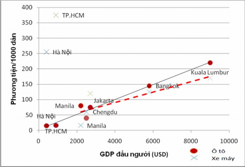
Figure 1-6: Relationship between vehicle ownership and GDP per capita (USD)
Source: Author's drawing based on MVA data (2009) quoted from Houtrans (JICA.2004) [4]
1.1.2 2 9 Ho Chi Minh City traffic infrastructure
6
The current status of the city's transport network presented in the Transport Plan 5 shows that the city's transport currently depends almost entirely on the road network. Urban passenger transport by rail is not currently used. Waterway transport is limited by encroachment and silting on rivers and canals, by the clearance of bridges and by the semi-diurnal tide regime with fluctuating levels.
6 Tedi South (2008)[3]
large movements have not yet created a complete system to exploit the advantages of water transport.
Road infrastructure is assessed as not commensurate with demand. The total length of roads of all levels in the City according to the Planning Report is currently about 3,000 km. Of which, only about 14% of the roads have a roadway width of over 12m, convenient for transporting passengers by bus, 51% are 7m - 12m wide and can only accommodate cars and minibuses, the rest are roads with a width of less than 7m, only enough for two-wheeled vehicles.
7
8
9
10
Land area for traffic is only about 9% - 17% of the total area in most districts, lower than the requirement of a special urban area of 24% - 26% 6 . This ratio can be even smaller when the roads in new districts have lower road surfaces than the tide level 7 and more than 50% of the City's area is less than 2m above sea level, so there is a high possibility of flooding 8 . The City has more than 1,350 traffic intersections with 120 important intersections, but only 9 are grade-separated intersections. Some important intersections also intersect at the same level with railways. The system of stations and parking lots occupies an area of about 0.1% of the urban area, which is assessed in the Planning Report as being still small. Most of the stations and parking lots are located in the inner city, in inappropriate locations, with limited space, contributing to complicating the traffic situation.
The public transport system according to the 9th planning must meet 60%-70% of the travel demand in the city, but according to MVA's calculations (2009), public transport only accounts for less than 5% of the market share. In cities with similar levels of development, the market share of buses is often
7 Decree No. 11/2010/ND-CP on management and protection of road traffic infrastructure.
8 Tedi South (2008), pp. 2-1 [3].
9 Tedi South (2008) [3] cited the source of Ho Chi Minh City Urban Planning Institute and Nikken Sekkki Consulting Company, "Research on adjusting the general construction planning of Ho Chi Minh City to 2025", for Ho Chi Minh City People's Committee, 2008, page 1-1.
10 City People's Committee (1996) [11].
11
12
accounting for 50% - 60% 1 0 . More worryingly, the City's public transport has seriously regressed. If in 1976, the city had 1,000 buses meeting 10% of the needs of 3 million people at that time, then in 2004, the city had 2,840 buses meeting 3.2% of the travel needs of 6.2 million people 1 1 .
The reason is that the operation of the bus system is limited by the weaknesses of the road traffic infrastructure mentioned above, with up to 35% of the road network being less than 7m wide, reducing the coverage of the route network and reducing the efficiency of operation. More importantly, the city bus system is also limited by the administrative management mechanism. The Public Passenger Transport Management and Operation Center under the Department of Transport is responsible for operating public transport businesses.
This mechanism does not create a connection between the profit and service responsibility of enterprises as well as the coordination of activities between enterprises to form a complete network system, convenient transit while this is the vital factor of a public transport system. Tedi South (2008) said that the bus network coverage index (only counting roads with a width of over 7m) is 1.15km/km, which shows that the unscientific organization of routes causes route duplication.
Thus, it can be seen that poor transport infrastructure needs to be improved, especially the public transport system.
11 Nguyen Xuan Thanh (2008), page 3 [9].
12 Tedi South 2008, page 2-1 [3]
13
1.2 1 0 Development of public transport and subway system (MRT) 12
Faced with the pressure of increasing traffic demand and the great damage caused by traffic jams, the city government has proposed in the Traffic Development Plan and simultaneously implemented the following policies to improve the traffic situation:
1. Develop the current road system.
2. Limit personal vehicles.
3. Develop public transport system (bus and MRT).
14
According to the Transport Development Plan, to organize traffic for a large urban area, it is necessary to first form a basic road network including transit and external traffic routes: radial roads, belt roads, and radial roads of all levels. However, the development of additional new roads in the network will only be implemented in areas outside of Ring Road No. 2 such as Cu Chi and Binh Chanh, partly because the basic road network in the inner city has been shaped, partly because opening more roads in the inner city is not realistic due to the high level of urbanization . 13 With such orientation, the first solution has a rather limited effect in reducing the pressure on traffic demand in the inner city and the effect is only temporary. Expanding and renovating roads can reduce congestion, but on the other hand, it can encourage more personal vehicles to participate in traffic when the city is still an economic center that attracts large and long-term immigrants.
Policies to limit personal vehicles such as car fees, emission fees... will also not be possible without developing a public transport system as an alternative means of transport.
13 Mass Rapid Transit.
14 Tedi South (2008) [3]
On the other hand, if this solution is implemented alone, it will restrict traffic and may have a negative impact on the city's economy.
Therefore, in the system of solutions, building a modern public transport system will be the core solution. Experience from other countries also shows that the development of public transport systems needs to be appropriate to the population size (Table 2-2). The current population of the city is over 7 million people and according to the forecast of the Transport Development Plan, by 2020 it will reach 10 million, the inner city area will be 6 million people, the traffic volume on the main roads in the center will reach about 16 - 26 thousand people/hour/direction.
Table 1-2: Relationship between population size and required means of transport
Population size
(1,000 people)
Maximum flow (person/time/direction) | Means of transport | |
15 - 20 | - | Personal vehicle |
20 - 60 | < 1,000 | Bus + private car |
60 - 100 | 1,000 – 2,000 | Bus is main + personal car |
100 - 300 | 2,000 – 6,000 | Bus is main + taxi + private car |
300 - 500 | 6,000 – 8,000 | Tram + Bus + Taxi + Private Car |
500 – 1,000 | 8,000 – 12,000 | Light rail + Tram + Bus + taxi + private car |
>1,000 | >12,000 | Urban and suburban railways; subways and the above mentioned means of transport. |
Maybe you are interested!
-

 Investment-cash flow relationship in the context of state ownership and banking system reform in Vietnam - 3
 -
 The impact of state ownership and bank loans on investment decisions of companies in Vietnam - 18
 -
 The relationship between travel motivation, destination image and destination choice - A case study of Binh Dinh province tourism destination - 1
 -
 The Impact of Investor Protection Rights on the Relationship Between Liquidity and Firm Value
 -
 Relationship Between Research Variables in the Model
Source: Tedi South 2008, page 6-2 [3]
When comparing the current population status and the Planning forecast with Table 2-2, we see that the city's current public transport system should have had an inner-urban - suburban railway system; a subway connected to the bus network with the support of other means of transport.
Thus, building an MRT system that is well integrated with an improved bus system while applying measures to limit inefficient means of transport will be an optimal solution for the city. This system will contribute to promoting the formation of satellite towns around the city, thanks to which long-distance travel is fast, safe, and accurate, and this also helps reduce traffic pressure in the inner city.
CHAPTER 2
2 MRT PROJECT DESCRIPTION
2.1 1 1 Route
The city's MRT system planning was approved by the Prime Minister in January 2007, including the routes shown in Figure 3-1. The urban railway network includes 06 metro lines, 02 monorail lines and 01 tram line with a total length of 109km with the following route directions:
Line 1: Ben Thanh – Suoi Tien, 19.7 km long (Orange line).
Line 2: Tham Luong - Ben Thanh - Thu Thiem, 12.3km long (Red line).
Line 3: Mien Dong – Phu Lam, 13 km long and will be extended north to Thu Duc (Dark blue line).
Route 4: Go Vap Intersection – Khanh Hoi, 11.3km long and will be extended in both directions (Green route).
Route 5: A semicircular curve to the Northwest from Binh Thanh through Phu Nhuan then running towards Binh Chanh, 17km long (Pink route).
Line 6: The North-South section connecting Line 2 with Line 3 is located in the western part of the city, 6km long (Red-brown line).
Ground tram line (XĐ1): Thu Thiem - Mien Tay bus station, 12.5km long (Color line)
black).
Southern monorail line (XĐ2): The semicircular curve to the Southeast, connecting District 2 and District 7, running along Nguyen Van Linh Avenue and meeting Line 5 in Binh Chanh, 14km long (Gray Line).
Northern monorail line (XĐ3): Quang Trung Software Park – Nguyen Oanh, providing passenger collection service for line 4, 8.5km long (Gray line).
Figure 2-1: MRT routes according to approved planning
Source: Website of the Urban Railway Management Board (http://www.hcmc-maur.vn/en/)
However, in response to the changing needs of the city's traffic and the need for a longer-term vision, the city has proposed revising this planning board in the direction of extending Line 1 and revising the direction of Line 3, as shown in Figure 3-2.
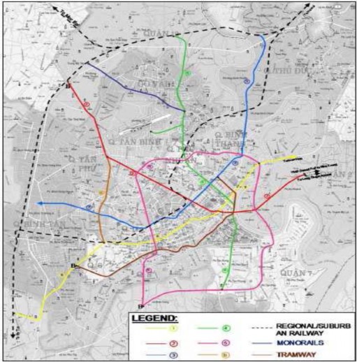
Figure 2-2: “Optimal” MRT routes according to proposed planning revisions
Source: MVA (2009) [4]
Route 1: Extends to the Southwest in the direction of the old Route 3 (yellow). Route 2: Extends to the North to An Suong bus station (red).
Line 3: A new Line 3 runs parallel to the old direction (blue). Line 4: Adjusted section around Ben Thanh market to go close to the riverbank (green).
Extend the tram line (XĐ1) to the North to transfer to the new Line 3 and expand the network's accessibility in the central area (brown line).