Chapter 2. IDENTIFICATION OF ARCHITECTURAL MONUMENTS AT THE SITE
ROSE GARDEN
Currently, through excavations at the Vuon Hong site, architectural relics have been identified, including 3 architectural relics of the Dai La period, 4 architectural relics of the Ly period, 1 architectural relic of the Tran period, 3 architectural relics and 1 citadel foundation relic of the early Le period, 4 architectural relics and 1 citadel foundation relic of the Later Le period.
2.1. Architectural relics of Dai La period
In general, at the excavation site of the Rose Garden (area G), the Dai La period architecture discovered in the Rose Garden area mostly only has traces of column foundations remaining, other components have been destroyed and are no longer identifiable.
2.1.1. Traces of architectural foundation
In the structure of a building, in order from bottom to top, the foundation is the lowest structure of the building. Based on the current state of the exposed relic, the foundation is understood as the component that makes up the architecture, made of soil, located at the bottom of the building, with the function of receiving and transmitting the load of the building to the bottom, which is the phenomenon of many different layers of clay being compacted to create the architectural foundation.
Within the exposed area, traces of foundations can be identified on almost the entire surface of the excavation pits. In contrast to the entire clay layer above, the structure of this cultural layer belongs to the primary soil layer originating from alluvial clay mixed with sand of the Red River, uniformly pinkish brown and dark gray in color due to mixing with coal ash and plant remains left by human activities, with an average thickness of about 0.5m.
Foundation construction technique: the clay used here is relatively uniform, consisting of two layers of soil: a pinkish-brown alluvial layer with few artifacts and a black mud layer, artifacts concentrated in areas of darker black mud.
2.1.2. Architectural background
Through architectural relics, the distinction between the foundation and the foundation is relative, because many architectural foundation locations are a continuation of the foundation, without any separating boundary. The location of the foundation is often above the foundation, that is, after building the foundation, people continue to use soil to build the architectural foundation.
The identified surface remains include a strip of architectural materials extending from East to West, including bricks, tiles, ceramics, and some animal bones.
but mainly gray tile pieces are mixed together with a fairly high density in the south of excavation pit G02 (X: 65 to X: 69; Y: 261 to Y: 282). And a part consisting of square gray floor tiles arranged in a straight line, there are 4 pieces left, of which 2 are quite intact, 1 is missing a southwest corner and 1 is only fragmented. Dimensions: North South x East West: 81 x 68 (cm). At architecture 12.VH.DL.KT001 and 12.VH.DL.KT.002.
In addition, the ground surface is also identified within a range of about 26.8 m 2 in the East-West direction, in the coordinate grid X: -49.90 to -54.30 and Y: -268.80 to - 273.18. When exposed on the surface of the relic is a layer of gray tiles about 3cm - 5cm thick, rectangular in shape, measuring 4m East - West, 6.7m North - South. The tiles are spread in layers, with fairly even thickness, mostly 2 layers overlapping each other.
2.1.3. Rectangular architectural plan
Based on the traces of foundations, floors, column foundations... it is possible to recognize the scale of the architectural plans of the Dai La period at the Hong Garden site including: 12VH.KT.ĐL001; 12VH.KT.ĐL002 with a rectangular layout.
- Architectural relic 12VH.DL.KT001
Architectural relic 12.VH.DL.KT 001 was identified with 10 exposed column foundations at pits G01 and G02, with the exposed column foundations from excavation layer L08 to excavation layer L12, with an elevation of +5m to +5.7m above sea level.
Row 1 of excavation pit G01 (North) includes 05 column foundations, row 2 of excavation pit G02 (South) includes 05 column foundations. The architecture is in the East - West direction.
The column foundations of row 1 are marked from East to West as follows: G01.L9.MT137, G01.L9.MT134, G01.L8.MT119, G01.L8.MT120, G01.L12.MT151.
Column foundations of row 2 have symbols: G02.L8.MT303, G02.L10.MT302, G02.L11.MT301, G02.L8.MT300, G02.L10.MT285.
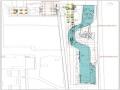
The column foundations are distributed in an area of about 118.8m2 ( East - West 18m, North - South 6.6m), within the coordinate grid of X -51, Y-264 to X-51, Y-282 and X -58, Y-264 to X -58, Y-282 (See Ba 01-09; Schedule 1; Bv 2-3).
* List of parameters of architectural monument column foundations 12.VH.DL.KT001
Archaeological symbols
Size | Construction materials | Construction engineering | |
Column foundation row 1 | |||
Maybe you are interested!
-
 Architectural relic at the Rose Garden site, 36 Dien Bien Phu, Hanoi - 12
 -
 Number of Ranked Architectural and Artistic Monuments Classified by Unit
 -
 Restoration and Restoration of Monuments Associated with the Construction and Development of Zen Tourism
 -
 15th-18th century architectural materials in the Kinh Thien Hoang Palace area of Thang Long citadel through excavation documents in 2017-2019 - 16
 -
 Computer Architecture Course - 10

Size | Construction materials | Construction engineering | |
MT.137 | 1.2 x 1.12m x 1.35m | Broken gray tiles in the shape of a trough mixed with purple-pink soil or yellow clay or alluvial sand and logs | First, dig a deep hole, the foundation pit is in the shape of a trapezoid, gradually narrowing to the bottom, with a basin-shaped bottom, a layer of broken tiles is lined at the bottom, and a log is placed on top, then a column is erected in the center of the foundation pit, and the column is compacted around it. Usually, each layer of tiles has a layer of clay and sand to fill the gaps between the tiles before compacting - water may also be sprinkled during the foundation compaction process. |
MT.134 | 1.13 x 1.28 x 0.8m | nt | nt |
MT.119 | 1.2 x 1.12 x 1.35m | nt | nt |
MT.120 | 0.95 x 1.1 x 1.2m | nt | nt |
MT.151 | 1.15 x Kxđ x 0.36m | nt | nt |
Column 2 foundation row | |||
MT.303 | 0.45 x 1.17 x 0.65m | Broken gray tiles in the shape of a trough mixed with purple-pink soil or yellow clay or alluvial sand | nt |
MT.302 | 1.1 x 1.1 x Kxđ | Broken gray tiles in the shape of a trough mixed with purple-pink soil or yellow clay or alluvial sand and wood | nt |
MT.301 | 1.3 x 1.3m x 1.3m | nt | nt |
MT.300 | 1.3 x 1.3m x 2m | nt | nt |
MT.285 | 0.93 x 0.32 x 0.73m | nt | nt |
Archaeological symbols
The main materials used to reinforce the column foundations are tiles, clay and logs, in which most of the tiles and logs are only reinforced at the bottom of the wooden columns. The column foundations with dense tile materials from the top to the bottom are less numerous. In particular, unlike many Dai La architectural units found in other areas (especially area E), in the column foundation system of the 12VH.KT.ĐL001 architecture, yellow sand is almost not used to reinforce the column foundations, but instead, sand is used to fill the gaps in the tile layers at the bottom of the column foundations.
The technique of digging column foundation pits is quite uniform in shape but not uniform in size. The column foundations are all trapezoidal blocks that gradually narrow to the bottom, with a cylindrical or basin-shaped bottom. The mouth size is mostly 120cm-140cm wide, very few foundations have mouths wider than or equal to 200cm. However, the depth of the column foundation is quite uniform, averaging 100cm. This can be explained by the fact that the column foundations of Dai La architecture were severely destroyed by the Ly Dynasty architecture above (LY.KT001), so only the bottom part remains.
Architectural scale: shown through the number of compartments on the determined architectural plan, accordingly the current architecture has 4 compartments, the distance between compartments ranges from 4.0m - 4.1m (Table) [2:60-71].
*Table: Architectural division through the distance between rows of column foundations (West - East direction)
Tt
Division | Column foundation symbol | Distance (m) | |
1 | First room | MT151 - MT120 | 4 |
MT285 - MT300 | 4 | ||
2 | Room 2 | MT120 - MT119 | 4 |
MT300 - MT301 | 4.05 | ||
3 | Room 3 | MT119 - MT134 | 4 |
MT301 - MT302 | 4 | ||
4 | Room 4 | MT134 - MT137 | 4.1 |
MT302 - MT303 | 4 |
In addition, the architectural structure is shown through the number of column foundations in a truss. According to the current exposed architecture, there are 5 trusses, each truss includes 2 column foundations forming a single distance with an average measurement of 5.1m to 5.2m (Table) [2:60-71]..
* Schedule: Column foundation distance from North to South (column foundation row order from West to East)
Tt
Column foundation row (vase) | Column foundation symbol | Distance (m) | |
1 | Row 1 | MT151 - MT285 | 5.1 |
2 | Row 2 | MT120 - MT300 | 5.2 |
3 | Row 3 | MT119 - MT301 | 5.1 |
4 | Row 4 | MT134 - MT302 | 5.1 |
5 | Row 5 | MT137 - MT303 | 5.15 |
Comment: This is an architecture with a very uniform space: 4m to 4.1m, but due to many excavations, the distance between the spaces cannot be determined accurately. Therefore, the actual measurements are often off by about 10cm to 30cm.
Based on the current state of exposure as well as the architectural steps, it can be initially assumed that the architecture 12VH.DL.KT.001 belongs to the type of long house with 2 rows of columns consisting of many equally wide rooms, possibly without lean-tos, running in the East - West direction in the North of the Rose Garden excavation area and is relatively consistent with the exposed architectures in area E.
- Architectural relic 12VH.DL.KT002
Architecture 12VH.DL.KT.002 was identified as exposed with a ground plan of 6 column foundations belonging to excavation pits G01 and G02, located to the East of architecture 12VH.DL.KT001.
The architecture is located in the North - South direction, in the coordinate range from X -44,1, Y -256,9; X - 57,3, Y -256,9 and X -44,1, Y -264,5; X -57,3, Y -264,5, with an area of about 149.38m 2
(North-South: 23.6m, East-West: 6.33m). The ground plan shows the column foundations from layers 10 to 12, with an elevation of +4.41m to 4.56m above sea level.
The Eastern column foundation row consists of 2 column foundations: L12.MT115 and L12.MT175. The Western column foundation row consists of 6 column foundations, the column foundation symbols from North to South are as follows: L10.MT152, L7.MT167, L12.MT162, L12.MT161, L12.MT149, L9.MT304. (See Ba 15-17; Bv 2-3; Table 02)
* List of parameters of architectural monument column foundations 12.VH.DL.KT002
Archaeological symbols
Size | Construction materials | Construction engineering | |
MT175 | 1.1 x 1.66 x 1.1m | Broken gray tiles in the shape of a trough mixed with purple-pink soil or yellow clay or alluvial sand and logs | First, dig a deep hole into the ground level of the house, the foundation pit has a trapezoidal shape that gradually narrows to the bottom, with a basin-shaped bottom. Then, a layer of broken tiles is lined at the bottom, and a log of wood is placed on top, and a column is erected in the center of the foundation pit. Around the column, a large number of gray broken tiles are compacted in the shape of a trough. Usually, each layer of tiles has a layer of clay and sand to fill the gaps between the tiles before compacting - water may also be sprinkled during the foundation compaction process. |
MT165 | 1.11m x 1.15m | nt | nt |
MT162 | 1.26m x 1.5m | nt | nt |
MT161 | 1.14m x 1.22m | nt | nt |
MT149 | 1.25m x 1.74m | nt | nt |
MT304 | 1.16m x 1.25m | nt | nt |
The column foundation system of Dai La architecture 12VH.ĐL.KT002 is of similar size to the column foundations of another Dai La architecture located in the West with the symbol 12VH.KT.ĐL001.
The technique of digging column foundation pits is quite uniform in shape but not uniform in size. The column foundations are all trapezoidal blocks that gradually narrow to the bottom, with rectangular or basin-shaped bottoms. The mouth size is mostly from 120cm - 170cm wide, very few foundations have mouths wider than or equal to 200cm. However, the depth of the column foundation is quite uniform, averaging 100cm. This can be explained by the fact that the column foundations of Dai La architecture were severely destroyed by the Ly Dynasty architecture above (LY.KT001), so only the bottom part remains.
Through the exposed vestiges, we can see that the architectural scale is shown through the number of compartments. Accordingly, the relic has a layout consisting of 4 rows of column foundations forming 3 compartments with an average width of 3.2m to 3.4m, equivalent to each other (Table) [2:60-71].
*Table: Architectural scale 12.VH.ĐL.KT02 through the distance between the rows of column foundations (South - North)
Tt
Division | Column foundation symbol | Distance (m) | |
1 | Room 1 | MT304 - MT149 | 3.3 |
Kxđ | Kxđ | ||
2 | Room 2 | MT149 - MT161 | 3.4 |
Kxđ - MT165 | 3.4 | ||
3 | Room 3 | MT161 - MT162 | 3.2 |
MT165 - MT175 | 3.2 |
The architectural structure is calculated according to the number of column foundations of the truss system, accordingly, the architectural truss consists of 2 column foundations, with an average width of 3.6m (Table) [2, pp.60 - 71].
* Schedule: column foundation distance in East - West direction (South to North)
Tt
Column foundation row (vase) | Column foundation symbol | Distance (m) | |
1 | Row 1 | MT304 - Kxđ | Kxđ |
2 | Row 2 | MT149 - Kxđ | Kxđ |
3 | Row 3 | MT161 - MT165 | 3.6 |
4 | Row 4 | MT162 - MT175 | 3.6 |
Comment: This is an architecture with a fairly uniform span of about 3.6m, but due to extensive excavation, the distance between the spans cannot be determined accurately. Therefore, the actual measurements are often off by about 10cm to 30cm. Based on the current state of exposure as well as the span of the architecture, it can be initially assumed that the architecture 12VH.KT.ĐL002 belongs to the type of long house with 2 rows of columns consisting of many equally wide spans, running in the North - South direction in the North of the excavation area of the Rose Garden and is relatively consistent with the exposed architectures in area E.
2.1.4. Citadel foundation relic
This is a very special type of relic that has been discovered for the first time in the Thang Long Imperial Citadel relic site and is being further researched and understood in this excavation.
The citadel foundation relic is identified by a dense system of buried piles and a layer of dark brown vegetation along with many pieces of Dai La period architectural materials exposed at excavation pits G03 - G04. The relic range in the coordinates of Thang Long Imperial Citadel is from X: - 85 to X: - 120 and from Y: - 260 to Y: - 286 with an area of over 900m2 of the two pits.
Excavation. The exposed surface is 3m above the average depth of the pit and 5.8m above average sea level.
The monument is composed of layers of reinforcing materials and a dense pile system, apparently used for construction to prevent subsidence over a large area on weak ground. The structure of the layers of the monument in order from bottom to top is as follows [2]:
The bottom layer is a gray and blue-gray clay layer, mixed with some pieces of rough ceramics and Dai La-era glazed pottery. The bottom of this layer is very pure, containing absolutely no cultural relics, however, wooden stakes are driven deep into this layer of soil. This is determined to be the soil layer of the excavation pit.
+ Vegetation layer: 5cm - 10cm thick, dark brown, spread along the north - south direction and continues to expand to the East and West, with only a few small sections spread evenly in the East - West direction. This is a carpet layer of soft-stemmed plants spread in order with the purpose of creating a foundation, preventing subsidence for the upper layers of materials.
+ The reddish brown and grayish brown clay layer, located on top, contains dense fragments of red and gray bricks from the Dai La period, directly covering the vegetation layer, densely distributed in the northern half and part of the southern half. All bricks are in a broken state, with an average thickness of 4.5cm - 6cm, many of which have embossed Chinese characters "Giang Tay Quan" in a rectangular embossed frame on the brick surface and rope decoration.
+ Wooden pile system: Wooden piles are driven from top to bottom, through the reinforcement layers: brick layer, vegetation layer and down to the bottom gray-green soil layer. According to the current status, within the area of 462m2 ( North - South direction: 21m, East - West direction: 22m) of the relic, a total of 984 wooden piles were discovered. The wooden piles are driven close to or adjacent to each other (the average distance between wooden piles is 20cm. (See Ba 15-17; Bv 04)
The exposed wooden piles are all in a rotten state, dark brown in color and partially cracked. The top of the pile is very rotten, has a pyramidal or flat shape, the cross-section of the pile body is circular, the foot of the pile is cut into a triangular and trapezoidal shape... The special thing about the wooden pile relics of the Dai La period is that the wooden piles are driven together or close together, not in a certain order in the middle of the wooden pile range. However, in the surrounding area (the western and southern edges) of the wooden pile range, there are 2 to 3 rows of piles driven in a straight line in the East - West and North - South direction, possibly to show the limit of the foundation or some architecture above.
Wooden pile size: The average length (height) of a wooden pile is from 0.8m - 1.5m, some piles are up to more than 2m long, the average diameter is from 10cm - 20cm, the length of the beveled pile foot is from 20cm - 50cm.
In addition to the wooden stakes as above, 102 traces of stake holes were also discovered with small round holes, with an average diameter of 10cm - 25cm. These round holes appeared on the clay foundation of the Ly Dynasty architecture, with the characteristics of a dark brown soil layer, in the form of mud, soft, with no artifacts inside. Initially, we determined that these were traces of stake holes, however, when we conducted an excavation and inspection, there was absolutely no appearance of wooden stakes.
This is the first time in the excavation that traces of wooden stakes were found with such a dense and continuous density. Therefore, to have an overview of the wooden stakes and from there to understand the scale, nature and function, it is necessary to continue research based on historical sources and archaeological excavation results.