Average humidity is above 75%, from July to October air humidity is usually above 80%, from January to March air humidity is often low, sometimes below 70%.
District 6 is clearly influenced by the West and Southwest monsoons. The West and Southwest monsoons affect District 6 from May to October, giving District 6 the hot, humid characteristics of the sea and causing heavy rain.
District 6 has two canal systems running through it, Lo Gom Canal runs along the inner area of District 6, dividing District 6 into two distinct parts and Lo Gom Canal runs parallel to Vo Van Kiet Avenue, which is the boundary between District 6 and District 8. The canals are a source of drainage for daily life and production activities in residential areas. The water level of the canals is usually low. However, on days of heavy rain combined with high tides, the water in the canals can rise, causing flooding in the surrounding area.
Regarding land, as an inner-city district of Ho Chi Minh City, District 6 is planned for economic development in the direction of modernity and urban standards, so there is no land for agricultural use here. The land area of District 6 is almost completely concreted for residential purposes and public works.
* Socio-economic conditions
District 6 has a relatively small population compared to other districts in the city. In 2017, the population of District 6 was 262,757 thousand people, accounting for 3.04% of the population and ranked 11th in the whole city. District 6 has a fairly high population density, more than 35 thousand people/km2 , ranked 6th in the city (2017). The main ethnic groups are Kinh and Hoa, so District 6 society has many mixed features of Kinh - Hoa culture.
District 6 has 6 markets: Binh Tay market, Minh Phung market, Binh Tien market, Phu Lam market, Phu Dinh market and Ho Trong Quy market. Of which, Binh Tay market is large in scale and is one of the important commodity hubs of the city. There is District 6 hospital located in the central area (Ward 11) and preventive medical centers in the wards. Cho Lon bus station is an important traffic hub in the area.
The road system of District 6 is quite good, the two main road systems connecting the east-west axis are Hong Bang and Hau Giang, which are the two key routes of the district.
In addition, upgrading the network system and building model routes have helped change the face of the district's traffic in recent times.
However, the drainage infrastructure of District 6 still has many limitations due to the lack of synchronous construction planning, leading to frequent flooding during the rainy season. This is an issue that needs to be addressed to limit the impact on people's lives.
District 6 is a part of Ho Chi Minh City, so the policies in District 6 are always oriented and built from the city's policies. In addition, the policies of District 6 are put forward to suit the development characteristics of the District, which is the basis for the socio-economic development of the district.
The development policies on trade and services, the construction of specialized roads and urban beautification policies are typical and concentrated development policies of District 6. These policies promote the natural and socio-economic strengths of District 6.
2.2. Factors affecting the quality of life of residents in District 6
2.2.1. Geographical location
District 6's geographical location is affected by the equatorial monsoon climate, so activities here are affected by the year-round hot weather.
District 6 is not in the city center, so it does not have an important strategic position. However, it is the gateway to the southwest of the city, connecting the central area with Binh Tan district, Binh Chanh district, Long An province and the provinces of the Southwest. District 6 has also affirmed its role in connecting and trading activities. Thanks to that, the district's economy and trade have many conditions for development, creating a premise to improve the quality of life of the residents here.
At the same time, with its position as a bridge between the inner and outer city, security and political management here also poses many challenges, potentially negatively affecting the CLCS through social evils, complexity in trading activities, etc.
Major routes such as Vo Van Kiet, Hau Giang, Hong Bang, Kinh Duong Vuong, Binh Tien are important routes that help connect District 6 with other districts and surrounding provinces.
The location near Mien Tay bus station, also home to Cho Lon bus station, District 6 is highly appreciated for its cargo and passenger transportation activities, contributing to improving service quality and people's lives.
Regarding administrative division, District 6 has 14 wards numbered from 1 to 14.
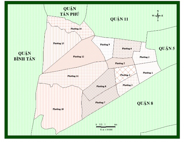
Figure 2.1. Diagram of administrative boundary division of 14 wards of District 6
(Source: Author design via MapInfo)
The major wards of the district include wards 10, 11, 12, 13, mainly concentrated in the west of the district. The basis for dividing the wards is mainly due to the uniformity of natural and socio-economic factors for ease of management; with the wards in the east, due to bustling economic activities and being the administrative center of the district, they are divided with
small scale to manage in-depth activities, to increase efficiency in management and socio-economic development.
It can be seen that with this location, District 6 has potential in socio-economic development, especially in the field of trade and services. People here also do not suffer from overloaded means of transportation during rush hour like in the central districts.
2.2.2. Natural factors
2.2.2.1. Terrain
With low terrain conditions with an average height of only about 1m, it can be seen that planning and constructing large and small projects is easy and convenient, especially apartments, commercial centers, roads, etc.
However, the low terrain elevation is the point that causes many difficulties for life. The average elevation is only about 1m, combined with rain and high tides, easily causes flooding in the District. Flooding caused by rain and water from the sewer system has a negative impact on the quality of life of residents, causing many difficulties in traffic, daily life, damaging property and especially causing some infectious diseases. Improvements to the District's drainage system in recent years have somewhat improved the level of flooding here, but the solution has not been thorough enough to cause some impact on people's lives.
2.2.2.2. Land
Most of the land in District 6 has been concreted. With a land area of about 713.8 hectares, of which 46.5% is specialized land and 49.0% is residential land, it can be seen that most of the land in District 6 has been used for a purpose and is not used for agricultural production at all.
District 6 has a small area, so the land is mainly used for residential purposes and specialized administrative and service works. Planning and constructing large-scale territorial organizations (such as industrial parks) is quite difficult due to the small size and geographical fragmentation here.
2.2.2.3. Climate
District 6's climate has the characteristics of a sub-equatorial climate with two rainy and dry seasons.
With a large amount of radiation, the average monthly sunshine hours are up to 160 - 270 hours, high temperature with an average annual temperature of over 27 degrees Celsius, showing that District 6 has all the characteristics of a hot climate. However, at many times of the year, high temperatures are a major factor affecting human health and outdoor economic activities.
The average annual rainfall of District 6 is also high with an average of more than 1900mm/year, the average number of rainy days is 159 days. The heavy rain here helps cool down the hot weather days, however, the heavy rainfall combined with high tides and low terrain elevation are the main causes of flooding in the District, affecting people's lives.
With the climate changing seasonally but with few extreme weather events, economic activities and human life are quite stable whether it is the rainy or dry season. However, heavy rains also cause certain difficulties due to low terrain causing flooding or prolonged heat and dryness can also have a negative impact on human health.
Basically, the weather here rarely experiences extreme weather events and there are almost no storms, which helps people have a more stable life and economic activities operate more smoothly.
2.2.2.4. Water resources – organisms
In terms of water resources, Tan Hoa - Lo Gom canal is a canal running along District 6. This is a canal with a high level of pollution in the past, but in the first decade of the 21st century, thanks to the policy of relocating and clearing all people who built temporary houses along the canal as well as the dredging and cleaning process that took place regularly, the quality of the canal water improved significantly, reducing negative impacts on aesthetics, waterway traffic as well as people's health. However, there also needs to be plans and processes to completely resolve this pollution situation to bring a clean water source to the people.
For water consumption, it is used from Cho Lon water supply company, so most residents here have clean water to use at a reasonable price, thanks to which people do not depend on natural water (rain, canals, ...), thanks to which the CLCS is also significantly increased.
Regarding biology, District 6 is mainly industrial and service activities, so the biology here is poor. With 2 large parks, Binh Phu and Phu Lam, two places with many trees, most of District 6 does not develop flora. Regarding aquaculture, the survival of aquatic species on canal water sources that do not ensure quality is very difficult, that is why the biodiversity here is very poor.
2.2.3. Socio-economic factors
2.2.3.1. Population and labor
- Population
+ The population size in District 6 fluctuated during the period 2010-2017, but still on an upward trend. In 2010, the population of District 6 was 253,474 thousand people (accounting for 3.42% of the city's total population), in 2017, it increased by 9,283 people, reaching 262,757 thousand people.
Figure 2.2 shows that the population in District 6 has very little fluctuation, the proportion of District 6's population in the whole city is quite small, only about 3%. The small population size makes population management and job creation not too difficult, but also causes a shortage of diverse labor as well as hinders the construction of large-scale production forms that require a lot of labor. However, to assess the specific impacts of population on people's lives, we must determine through the population density, this is the basis for comparison, evaluation, and finding the cause and significance of population impact on the quality of life of residents in the area.
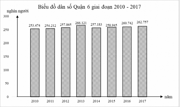
Figure 2.2. Population chart of District 6, 2010–2017
(Source: data processing from Ho Chi Minh City Statistics Office)
The natural population growth rate of District 6 is low, only 0.76% and the mechanical growth rate is also low, reaching 0.15% (2016).
In 2017, the population of the entire district was 262,757 people, of which Ward 12 had the largest population with 29,052 people, followed by Wards 11, 13, 8, 10, 14 with a population of over 23,000 people, the remaining wards had a population of less than 20,000 people, of which Wards 2 and 3 had the fewest residents, just over 10,000 people.
+ Regarding population distribution, District 6's population is unevenly distributed, mainly concentrated in the eastern part of the district. Wards with high population density include wards 4, 5, 6, 8, 14 with more than 50,000 people/km2, of which ward 5 has the highest population density (66,965 people/km2). Wards in the western part of the district have low population density (except ward 14), of which ward 10's population density is only 15,373 people/km2.
Table 2.1. Area, population, population density of wards in District 6 in 2017
(Source: Processed from District 6 statistical yearbook 2017)
Criteria
Ward
Acreage | Population | Population density (people/ km2 ) | |||
Quantity (ha) | Ratio (%) | Quantity (People) | Ratio (%) | ||
District wide | 713.82 | 100.0 | 262,757 | 100.0 | 36,801 |
1 | 29.14 | 4.1 | 12,897 | 4.9 | 44,259 |
2 | 24.44 | 3.4 | 10,046 | 3.8 | 41,105 |
3 | 22.95 | 3.2 | 10,381 | 4.0 | 45,233 |
4 | 21.13 | 3.0 | 13,480 | 5.1 | 63,796 |
5 | 22.77 | 3.2 | 15,248 | 5.8 | 66,965 |
6 | 31.40 | 4.4 | 16,428 | 6.3 | 52,318 |
7 | 47.64 | 6.7 | 15,043 | 5.7 | 31,576 |
8 | 41.03 | 5.7 | 25,536 | 9.7 | 62,237 |
9 | 26.90 | 3.8 | 13,274 | 5.1 | 49,346 |
10 | 154.54 | 21.6 | 23,758 | 9.0 | 15,373 |
11 | 91.94 | 12.9 | 27,241 | 10.4 | 29,629 |
12 | 73.09 | 10.2 | 29,052 | 11.1 | 39,748 |
13 | 84.02 | 11.8 | 26,798 | 10.2 | 31,895 |
14 | 42.83 | 6.0 | 23,575 | 9.0 | 55,043 |
Maybe you are interested!
-

 Current Status of Factors Affecting the Management of Life Skills Education for Students Through Experiential Activities at Gia Nghia District Secondary Schools
 -
 Some Factors Affecting the Quality of Short-Term Loan Services for Business Customers of Commercial Banks
 -
 Factors Affecting Craft Village Tourism Activities in Hong Van Commune, Thuong Tin District, Hanoi
 -
 Factors affecting customer satisfaction with the quality of international money transfer services at Dong A Commercial Joint Stock Bank - 1
 -
 Factors Affecting the Quality of Auditing Financial Statements of Banks Conducted by the State Audit Office
Uneven population distribution has a significant impact on the quality of life of residents in each locality. Places with a large population will create a working environment, bustling economic activities, attracting labor and the frequency of operation of public works and services is fully utilized, but issues of security, social order and safety