2.1.1.3. Greenhouse gas emissions issue
In Dak Lak province, GHG emissions are mainly in the following sectors: Agriculture, industry, transportation, minerals, and waste (Table 2.1).
Table 2.1: Main greenhouse gas emission sectors in Dak Lak province
Content
Greenhouse Gas Emitting Sector | |||||
Agriculture | Industrial | Transportation | Exploit Minerals | Waste | |
Activities causing GHG emissions primarily | - Wet rice cultivation - Abuse of chemical fertilizers - Burning by-products and straw - Livestock farming | - Agricultural and forestry processing - Steel production; materials construction materials; fertilizer; - Hydroelectricity and gas - Exploit Minerals | Engine fuel combustion from the source transportation | Burning engine materials of vehicles, machinery and equipment | - Solid waste landfill - Biological treatment of solid waste - Incineration and burning of waste; treatment and discharge wastewater |
Types of emissions primarily | N 2 O, N 2 O, CH 4 CO 2 | CO 2 , CH 4 , N 2 O, HFCs, PFCs | CO, N 2 O, VOCS | CO, N 2 O, CH 4 , HFCs | CO 2 , CH 4 , N 2 O |
Field size | - 592,785 ha (2019) area of cultivated land - 480 livestock farms | 1 Industrial Park, 8 CNN is live | 16,447 vehicles of all kinds | 75 mineral exploitation projects. | |
Maybe you are interested!
-
 Assessing the impact of climate change on livelihood security of ethnic minority communities in Dak Lak - 13
 -
 Areas, Sectors and Subjects Vulnerable to Climate Change Impacts in Quang Ninh Province
 -
 Impact of Climate Change on Sectors
 -
 Identify Rating Levels and Rating Scales
zt2i3t4l5ee
zt2a3gstourism,quan lan,quang ninh,ecology,ecotourism,minh chau,van don,geography,geographical basis,tourism development,science
zt2a3ge
zc2o3n4t5e6n7ts
of the islanders. Therefore, this indicator will be divided into two sub-indicators:
a1. Natural tourism attractiveness a2. Cultural tourism attractiveness
b. Tourist capacity
The two island communes in Quan Lan have different capacities to receive tourists. Minh Chau Commune is home to many standard hotels and resorts, attracting high-income domestic and international tourists. Meanwhile, Quan Lan Commune has many motels mainly built and operated by local people, so the scale and quality are not high, and will be suitable for ordinary tourists such as students.
c. Time of exploitation of Quan Lan Island Commune:
Quan Lan tourism is seasonal due to weather and climate conditions and festivals only take place on certain days of the year, specifically in spring. In Quan Lan commune, the period from April to June and from September to November is considered the best time to visit Quan Lan because the cultural tourism activities are mainly associated with festivals taking place during this time.
Minh Chau island commune:
Tourism exploitation time is all year round, because this is a place with a number of tourist attractions with diverse ecosystems such as Bai Tu Long National Park Research Center, Tram forest, Turtle Laying Beach, so besides coming to the beach for tourism and vacation in the summer, Minh Chau will attract research groups to come for tourism combined with research at other times of the year.
d. Sustainability
The sustainability of ecotourism sites in Quan Lan and Minh Chau communes depends on the sensitivity of the ecosystems to climate changes.
landscape. In general, these tourist destinations have a fairly high level of sustainability, because they are natural ecosystems, planned and protected. However, if a large number of tourists gather at certain times, it can exceed the carrying capacity and affect the sustainability of the environment (polluted beaches, damaged trees, animals moving away from their habitats, etc.), then the sustainability of the above ecosystems (natural ecosystems, human ecosystems) will also be affected and become less sustainable.
e. Location and accessibility
Both island communes have ports to take tourists to visit from Van Don wharf:
- Quan Lan – Van Don traffic route:
Phuc Thinh – Viet Anh high-speed boat and Quang Minh high-speed boat, depart at 8am and 2pm from Van Don to Quan Lan, and at 7am and 1pm from Quan Lan to Van Don. There are also wooden boats departing at 7am and 1pm.
- Van Don - Minh Chau traffic route:
Chung Huong high-speed train, Minh Chau train, morning 7:30 and afternoon 13:30 from Van Don to Minh Chau, morning 6:30 and afternoon 13:00 from Minh Chau to Van Don.
f. Infrastructure
Despite receiving investment attention, the issue of infrastructure and technical facilities for tourism on Quan Lan Island is still an issue that needs to be resolved because it has a direct impact on the implementation of ecotourism activities. The minimum conditions for serving tourists such as accommodation, electricity, water, communication, especially medical services, and security work need to be given top priority. Ecotourism spots in Minh Chau commune are assessed to have better infrastructure and technical facilities for tourism because there are quite complete and synchronous conditions for serving tourists, meeting many needs of domestic and foreign tourists.
3.2.1.4. Determine assessment levels and assessment scales
Corresponding to the levels of each criterion, the index is the score of those levels in the order of 4, 3, 2, 1 decreasing according to the standard of each level: very attractive (4), attractive (3), average (2), less attractive (1).
3.2.1.5. Determining the coefficients of the criteria
For the assessment of DLST in the two communes of Quan Lan and Minh Chau islands, the students added evaluation coefficients to show the importance of the criteria and indicators as follows:
Coefficient 3 with criteria: Attractiveness, Exploitation time. These are the 2 most important criteria for attracting tourists to tourism in general and eco-tourism in particular, so they have the highest coefficient.
Coefficient 2 with criteria: Capacity, Infrastructure, Location and accessibility . Because the assessment area is an island commune of Van Don district, the above criteria are selected by the author with appropriate coefficients at the average level.
Coefficient 1 with criteria: Sustainability. Quan Lan has natural and human-made ecotourism sites, with high biodiversity and little impact from local human factors. Most of the ecotourism sites are still wild, so they are highly sustainable.
3.2.1.6. Results of DLST assessment on Quan Lan island
a. Assessment of the potential for natural tourism development
For Minh Chau commune:
+ Natural tourism attractiveness is determined to be very attractive (4 points) and the most important coefficient (coefficient 3), so the score of the Attractiveness criterion is 4 x 3 = 12.
+ Capacity is determined as average (2 points) and the coefficient is quite important (coefficient 2), then the score of Capacity criterion is 2 x 2 = 4.
+ Exploitation time is long (4 points), the most important coefficient (coefficient 3) so the score of the Exploitation time criterion is 4 x 3 = 12.
+ Sustainability is determined as sustainable (4 points), the important coefficient is the average coefficient (coefficient 1), so the score of the Sustainability criterion is 4 x 1 = 4 points
+ Location and accessibility are determined to be quite favorable (2 points), the coefficient is quite important (coefficient 2), the criterion score is 2 x 2 = 4 points.
+ Infrastructure is assessed as good (3 points), the coefficient is quite important (coefficient 2), then the score of the Infrastructure criterion is 3 x 2 = 6 points.
The total score for evaluating DLST in Minh Chau commune according to 6 evaluation criteria is determined as: 12 + 4 + 12 + 4 + 4 + 6 = 42 points
Similar assessment for Quan Lan commune, we have the following table:
Table 3.3: Assessment of the potential for natural ecotourism development in Quan Lan and Minh Chau communes
Attractiveness of self-tourismof course
Capacity
Mining time
Sustainability
Location and accessibility
Infrastructure
Result
Point
DarkMulti
Point
DarkMulti
Point
DarkMulti
Point
DarkMulti
Point
DarkMulti
Point
DarkMulti
CommuneMinh Chau
12
12
4
8
12
12
4
4
4
8
6
8
42/52
Quan CommuneLan
6
12
6
8
9
12
4
4
4
8
4
8
33/52
b. Assessment of the potential for humanistic tourism development
For Quan Lan commune:
+ The attractiveness of human tourism is determined to be very attractive (4 points) and the most important coefficient (coefficient 3), so the score of the Attractiveness criterion is 4 x 3 = 12.
+ Capacity is determined to be large (3 points) and the coefficient is quite important (coefficient 2), then the score of the Capacity criterion is 3 x 2 = 6.
+ Mining time is average (3 points), the most important coefficient (coefficient 3) so the score of the Mining time criterion is 3 x 3 = 9.
+ Sustainability is determined as sustainable (4 points), the important coefficient is the average coefficient (coefficient 1), so the score of the Sustainability criterion is 4 x 1 = 4 points.
+ Location and accessibility are determined to be quite favorable (2 points), the coefficient is quite important (coefficient 2), the criterion score is 2 x 2 = 4 points.
+ Infrastructure is rated as average (2 points), the coefficient is quite important (coefficient 2), then the score of the Infrastructure criterion is 2 x 2 = 4 points.
The total score for evaluating DLST in Quan Lan commune according to 6 evaluation criteria is determined as: 12 + 6 + 6 + 4 + 4 + 4 = 36 points.
Similar assessment with Minh Chau commune we have the following table:
Table 3.4: Assessment of the potential for developing humanistic eco-tourism in Quan Lan and Minh Chau communes
Attractiveness of human tourismliterature
Capacity
Mining time
Sustainability
Location and accessibility
Infrastructure
Result
Point
DarkMulti
Point
DarkMulti
Point
DarkMulti
Point
DarkMulti
Point
DarkMulti
Point
DarkMulti
Quan CommuneLan
12
12
6
8
9
12
4
4
4
8
4
8
39/52
Minh CommuneChau
6
12
4
8
12
12
4
4
4
8
6
8
36/52
Basically, both Minh Chau and Quan Lan localities have quite favorable conditions for developing ecotourism. However, Quan Lan commune has more advantages to develop ecotourism in a humanistic direction, because this is an area with many famous historical relics such as Quan Lan Communal House, Quan Lan Pagoda, Temple worshiping the hero Tran Khanh Du, ... along with local festivals held annually such as the wind praying ceremony (March 15), Quan Lan festival (June 10-19); due to its location near the port and long exploitation time, the beaches in Quan Lan commune (especially Quan Lan beach) are no longer hygienic and clean to ensure the needs of tourists coming to relax and swim; this is also an area with many beautiful landscapes such as Got Beo wind pass, Ong Phong head, Voi Voi cave, but the ability to access these places is still very limited (dirt hill road, lots of gravel and rocks), especially during rainy and windy times; In addition, other natural resources such as mangrove forests and sea worms have not been really exploited for tourism purposes and ecotourism development. On the contrary, Minh Chau commune has more advantages in developing ecotourism in the direction of natural tourism, this is an area with diverse ecosystems such as at Rua De Beach, Bai Tu Long National Park Conservation Center...; Minh Chau beach is highly appreciated for its natural beauty and cleanliness, ranked in the top ten most beautiful beaches in Vietnam; Minh Chau commune is also home to Tram forest with a large area and a purity of up to 90%, suitable for building bridges through the forest (a very effective type of natural ecotourism currently applied by many countries) for tourists to sightsee, as well as for the purpose of studying and researching.
Figure 3.1: Thenmala Forest Bridge (India) Source: https://www.thenmalaecotourism.com/(August 21, 2019)
3.2.2. Using SWOT matrix to evaluate Quan Lan island tourism
General assessment of current tourism activities of Quan Lan island is shown through the following SWOT matrix:
Table 3.5: SWOT matrix evaluating tourism activities on Quan Lan island
Internal agent
Strengths- There is a lot of potential for tourism development, especially natural ecotourism and humanistic ecotourism.- The unskilled labor force is relatively abundant.- resource environmentunpolluted, still
Weaknesses- Poorly developed infrastructure, especially traffic routes to tourist destinations on the island.- The team of professional staff is still weak.- Tourism products in general
quite wild, originalintact
general and DLST in particularalone is monotonous.
External agents
Opportunity- Tourism is a key industry in the socio-economic development strategy of the province and Van Don economic zone.- Quan Lan was selected as a pilot area for eco-tourism development within the framework of the green growth project between Quang Ninh province and the Japanese organization JICA.- The flow of tourists and especially ecotourism in the world tends toincreasing
Challenge- Weather and climate change abnormally.- Competition in tourism products is increasingly fierce, especially with other localities in the province such as Ha Long, Mong Cai...- Awareness of tourists, especially domestic tourists, about ecotourism and nature conservation is not high.
Through summary analysis using SWOT matrix we see that:
To exploit strengths and take advantage of opportunities, it is necessary to:
- Diversify products and service types (build more tourism routes aimed at specific needs of tourists: experiential tourism immersed in nature, spiritual cultural tourism...)
- Effective exploitation of resources and differentiated products (natural resources and human resources)
div.maincontent .p { color: black; font-family:"Times New Roman", serif; font-style: normal; font-weight: normal; text-decoration: none; font-size: 14pt; margin:0pt; } div.maincontent p { color: black; font-family:"Times New Roman", serif; font-style: normal; font-weight: normal; text-decoration: none; font-size: 14pt; margin:0pt; } div.maincontent .s1 { color: black; font-family:"Times New Roman", serif; font-style: normal; font-weight: normal; text-decoration: none; font-size: 13pt; } div.maincontent .s2 { color: black; font-family:"Times New Roman", serif; font-style: normal; font-weight: normal; text-decoration: none; font-size: 13pt; } div.maincontent .s3 { color: #0D0D0D; font-family:"Times New Roman", serif; font-style: normal; font-weight: bold; text-decoration: none; font-size: 14pt; } div.maincontent .s4 { color: black; font-family:"Times New Roman", serif; font-style: italic; font-weight: normal; text-decoration: none; font-size: 14pt; } div.maincontent .s5 { color: black; font-family:"Times New Roman", serif; font-style: italic; font-weight: bold; text-decoration: none; font-size: 14pt; } div.maincontent .s6 { color: black; font-family:"Times New Roman", serif; font-style: italic; font-weight: normal; text-decoration: none; font-size: 14pt; vertical-align: -3pt; } div.maincontent .s7 { color: black; font-family:"Times New Roman", serif; font-style: italic; font-weight: normal; text-decoration: none; font-size: 14pt; vertical-align: -2pt; } div.maincontent .s8 { color: black; font-family:"Times New Roman", serif; font-style: italic; font-weight: normal; text-decoration: none; font-size: 14pt; vertical-align: -1pt; } div.maincontent .s9 { color: black; font-family:"Times New Roman", serif; font-style: normal; font-weight: normal; text-decoration: none; font-size: 14pt; } div.maincontent .s10 { color: black; font-family:"Times New Roman", serif; font-style: normal; font-weight: bold; text-decoration: none; font-size: 14pt; } div.maincontent .s11 { color: black; font-family:"Times New Roman", serif; font-style: normal; font-weight: normal; text-decoration: none; font-size: 14pt; } div.maincontent .s12 { color: black; font-family:Symbol, serif; font-style: normal; font-weight: normal; text-decoration: none; font-size: 14pt; } div.maincontent .s13 { color: black; font-family:Wingdings; font-style: normal; font-weight: normal; text-decoration: none; font-size: 14pt; } div.maincontent .s14 { color: black; font-family:"Times New Roman", serif; font-style: normal; font-weight: normal; text-decoration: none; font-size: 9pt; vertical-align: 5pt; } div.maincontent .s15 { color: black; font-family:"Times New Roman", serif; font-style: normal; font-weight: normal; text-decoration: none; font-size: 9pt; vertical-align: 5pt; } div.maincontent .s16 { color: black; font-family:Cambria, serif; font-style: italic; font-weight: normal; text-decoration: none; font-size: 14pt; } div.maincontent .s17 { color: #080808; font-family:"Times New Roman", serif; font-style: normal; font-weight: bold; text-decoration: none; font-size: 14pt; } div.maincontent .s18 { color: #080808; font-family:"Times New Roman", serif; font-style: normal; font-weight: normal; text-decoration: none; font-size: 14pt; } div.maincontent .s19 { color: black; font-family:"Times New Roman", serif; font-style: normal; font-weight: normal; text-decoration: none; font-size: 11pt; } div.maincontent .s20 { color: black; font-family:"Times New Roman", serif; font-style: normal; font-weight: normal; text-decoration: none; font-size: 10pt; } div.maincontent .s21 { color: black; font-family:"Times New Roman", serif; font-style: normal; font-weight: bold; text-decoration: none; font-size: 11pt; } div.maincontent .s22 { color: black; font-family:"Times New Roman", serif; font-style: normal; font-weight: normal; text-decoration: none; font-size: 11pt; } div.maincontent .s23 { color: black; font-family:"Times New Roman", serif; font-style: italic; font-weight: normal; text-decoration: none; font-size: 14pt; } div.maincontent .s24 { color: #212121; font-family:"Times New Roman", serif; font-style: normal; font-weight: normal; tex
Identify Rating Levels and Rating Scales
zt2i3t4l5ee
zt2a3gstourism,quan lan,quang ninh,ecology,ecotourism,minh chau,van don,geography,geographical basis,tourism development,science
zt2a3ge
zc2o3n4t5e6n7ts
of the islanders. Therefore, this indicator will be divided into two sub-indicators:
a1. Natural tourism attractiveness a2. Cultural tourism attractiveness
b. Tourist capacity
The two island communes in Quan Lan have different capacities to receive tourists. Minh Chau Commune is home to many standard hotels and resorts, attracting high-income domestic and international tourists. Meanwhile, Quan Lan Commune has many motels mainly built and operated by local people, so the scale and quality are not high, and will be suitable for ordinary tourists such as students.
c. Time of exploitation of Quan Lan Island Commune:
Quan Lan tourism is seasonal due to weather and climate conditions and festivals only take place on certain days of the year, specifically in spring. In Quan Lan commune, the period from April to June and from September to November is considered the best time to visit Quan Lan because the cultural tourism activities are mainly associated with festivals taking place during this time.
Minh Chau island commune:
Tourism exploitation time is all year round, because this is a place with a number of tourist attractions with diverse ecosystems such as Bai Tu Long National Park Research Center, Tram forest, Turtle Laying Beach, so besides coming to the beach for tourism and vacation in the summer, Minh Chau will attract research groups to come for tourism combined with research at other times of the year.
d. Sustainability
The sustainability of ecotourism sites in Quan Lan and Minh Chau communes depends on the sensitivity of the ecosystems to climate changes.
landscape. In general, these tourist destinations have a fairly high level of sustainability, because they are natural ecosystems, planned and protected. However, if a large number of tourists gather at certain times, it can exceed the carrying capacity and affect the sustainability of the environment (polluted beaches, damaged trees, animals moving away from their habitats, etc.), then the sustainability of the above ecosystems (natural ecosystems, human ecosystems) will also be affected and become less sustainable.
e. Location and accessibility
Both island communes have ports to take tourists to visit from Van Don wharf:
- Quan Lan – Van Don traffic route:
Phuc Thinh – Viet Anh high-speed boat and Quang Minh high-speed boat, depart at 8am and 2pm from Van Don to Quan Lan, and at 7am and 1pm from Quan Lan to Van Don. There are also wooden boats departing at 7am and 1pm.
- Van Don - Minh Chau traffic route:
Chung Huong high-speed train, Minh Chau train, morning 7:30 and afternoon 13:30 from Van Don to Minh Chau, morning 6:30 and afternoon 13:00 from Minh Chau to Van Don.
f. Infrastructure
Despite receiving investment attention, the issue of infrastructure and technical facilities for tourism on Quan Lan Island is still an issue that needs to be resolved because it has a direct impact on the implementation of ecotourism activities. The minimum conditions for serving tourists such as accommodation, electricity, water, communication, especially medical services, and security work need to be given top priority. Ecotourism spots in Minh Chau commune are assessed to have better infrastructure and technical facilities for tourism because there are quite complete and synchronous conditions for serving tourists, meeting many needs of domestic and foreign tourists.
3.2.1.4. Determine assessment levels and assessment scales
Corresponding to the levels of each criterion, the index is the score of those levels in the order of 4, 3, 2, 1 decreasing according to the standard of each level: very attractive (4), attractive (3), average (2), less attractive (1).
3.2.1.5. Determining the coefficients of the criteria
For the assessment of DLST in the two communes of Quan Lan and Minh Chau islands, the students added evaluation coefficients to show the importance of the criteria and indicators as follows:
Coefficient 3 with criteria: Attractiveness, Exploitation time. These are the 2 most important criteria for attracting tourists to tourism in general and eco-tourism in particular, so they have the highest coefficient.
Coefficient 2 with criteria: Capacity, Infrastructure, Location and accessibility . Because the assessment area is an island commune of Van Don district, the above criteria are selected by the author with appropriate coefficients at the average level.
Coefficient 1 with criteria: Sustainability. Quan Lan has natural and human-made ecotourism sites, with high biodiversity and little impact from local human factors. Most of the ecotourism sites are still wild, so they are highly sustainable.
3.2.1.6. Results of DLST assessment on Quan Lan island
a. Assessment of the potential for natural tourism development
For Minh Chau commune:
+ Natural tourism attractiveness is determined to be very attractive (4 points) and the most important coefficient (coefficient 3), so the score of the Attractiveness criterion is 4 x 3 = 12.
+ Capacity is determined as average (2 points) and the coefficient is quite important (coefficient 2), then the score of Capacity criterion is 2 x 2 = 4.
+ Exploitation time is long (4 points), the most important coefficient (coefficient 3) so the score of the Exploitation time criterion is 4 x 3 = 12.
+ Sustainability is determined as sustainable (4 points), the important coefficient is the average coefficient (coefficient 1), so the score of the Sustainability criterion is 4 x 1 = 4 points
+ Location and accessibility are determined to be quite favorable (2 points), the coefficient is quite important (coefficient 2), the criterion score is 2 x 2 = 4 points.
+ Infrastructure is assessed as good (3 points), the coefficient is quite important (coefficient 2), then the score of the Infrastructure criterion is 3 x 2 = 6 points.
The total score for evaluating DLST in Minh Chau commune according to 6 evaluation criteria is determined as: 12 + 4 + 12 + 4 + 4 + 6 = 42 points
Similar assessment for Quan Lan commune, we have the following table:
Table 3.3: Assessment of the potential for natural ecotourism development in Quan Lan and Minh Chau communes
Attractiveness of self-tourismof course
Capacity
Mining time
Sustainability
Location and accessibility
Infrastructure
Result
Point
DarkMulti
Point
DarkMulti
Point
DarkMulti
Point
DarkMulti
Point
DarkMulti
Point
DarkMulti
CommuneMinh Chau
12
12
4
8
12
12
4
4
4
8
6
8
42/52
Quan CommuneLan
6
12
6
8
9
12
4
4
4
8
4
8
33/52
b. Assessment of the potential for humanistic tourism development
For Quan Lan commune:
+ The attractiveness of human tourism is determined to be very attractive (4 points) and the most important coefficient (coefficient 3), so the score of the Attractiveness criterion is 4 x 3 = 12.
+ Capacity is determined to be large (3 points) and the coefficient is quite important (coefficient 2), then the score of the Capacity criterion is 3 x 2 = 6.
+ Mining time is average (3 points), the most important coefficient (coefficient 3) so the score of the Mining time criterion is 3 x 3 = 9.
+ Sustainability is determined as sustainable (4 points), the important coefficient is the average coefficient (coefficient 1), so the score of the Sustainability criterion is 4 x 1 = 4 points.
+ Location and accessibility are determined to be quite favorable (2 points), the coefficient is quite important (coefficient 2), the criterion score is 2 x 2 = 4 points.
+ Infrastructure is rated as average (2 points), the coefficient is quite important (coefficient 2), then the score of the Infrastructure criterion is 2 x 2 = 4 points.
The total score for evaluating DLST in Quan Lan commune according to 6 evaluation criteria is determined as: 12 + 6 + 6 + 4 + 4 + 4 = 36 points.
Similar assessment with Minh Chau commune we have the following table:
Table 3.4: Assessment of the potential for developing humanistic eco-tourism in Quan Lan and Minh Chau communes
Attractiveness of human tourismliterature
Capacity
Mining time
Sustainability
Location and accessibility
Infrastructure
Result
Point
DarkMulti
Point
DarkMulti
Point
DarkMulti
Point
DarkMulti
Point
DarkMulti
Point
DarkMulti
Quan CommuneLan
12
12
6
8
9
12
4
4
4
8
4
8
39/52
Minh CommuneChau
6
12
4
8
12
12
4
4
4
8
6
8
36/52
Basically, both Minh Chau and Quan Lan localities have quite favorable conditions for developing ecotourism. However, Quan Lan commune has more advantages to develop ecotourism in a humanistic direction, because this is an area with many famous historical relics such as Quan Lan Communal House, Quan Lan Pagoda, Temple worshiping the hero Tran Khanh Du, ... along with local festivals held annually such as the wind praying ceremony (March 15), Quan Lan festival (June 10-19); due to its location near the port and long exploitation time, the beaches in Quan Lan commune (especially Quan Lan beach) are no longer hygienic and clean to ensure the needs of tourists coming to relax and swim; this is also an area with many beautiful landscapes such as Got Beo wind pass, Ong Phong head, Voi Voi cave, but the ability to access these places is still very limited (dirt hill road, lots of gravel and rocks), especially during rainy and windy times; In addition, other natural resources such as mangrove forests and sea worms have not been really exploited for tourism purposes and ecotourism development. On the contrary, Minh Chau commune has more advantages in developing ecotourism in the direction of natural tourism, this is an area with diverse ecosystems such as at Rua De Beach, Bai Tu Long National Park Conservation Center...; Minh Chau beach is highly appreciated for its natural beauty and cleanliness, ranked in the top ten most beautiful beaches in Vietnam; Minh Chau commune is also home to Tram forest with a large area and a purity of up to 90%, suitable for building bridges through the forest (a very effective type of natural ecotourism currently applied by many countries) for tourists to sightsee, as well as for the purpose of studying and researching.
Figure 3.1: Thenmala Forest Bridge (India) Source: https://www.thenmalaecotourism.com/(August 21, 2019)
3.2.2. Using SWOT matrix to evaluate Quan Lan island tourism
General assessment of current tourism activities of Quan Lan island is shown through the following SWOT matrix:
Table 3.5: SWOT matrix evaluating tourism activities on Quan Lan island
Internal agent
Strengths- There is a lot of potential for tourism development, especially natural ecotourism and humanistic ecotourism.- The unskilled labor force is relatively abundant.- resource environmentunpolluted, still
Weaknesses- Poorly developed infrastructure, especially traffic routes to tourist destinations on the island.- The team of professional staff is still weak.- Tourism products in general
quite wild, originalintact
general and DLST in particularalone is monotonous.
External agents
Opportunity- Tourism is a key industry in the socio-economic development strategy of the province and Van Don economic zone.- Quan Lan was selected as a pilot area for eco-tourism development within the framework of the green growth project between Quang Ninh province and the Japanese organization JICA.- The flow of tourists and especially ecotourism in the world tends toincreasing
Challenge- Weather and climate change abnormally.- Competition in tourism products is increasingly fierce, especially with other localities in the province such as Ha Long, Mong Cai...- Awareness of tourists, especially domestic tourists, about ecotourism and nature conservation is not high.
Through summary analysis using SWOT matrix we see that:
To exploit strengths and take advantage of opportunities, it is necessary to:
- Diversify products and service types (build more tourism routes aimed at specific needs of tourists: experiential tourism immersed in nature, spiritual cultural tourism...)
- Effective exploitation of resources and differentiated products (natural resources and human resources)
div.maincontent .p { color: black; font-family:"Times New Roman", serif; font-style: normal; font-weight: normal; text-decoration: none; font-size: 14pt; margin:0pt; } div.maincontent p { color: black; font-family:"Times New Roman", serif; font-style: normal; font-weight: normal; text-decoration: none; font-size: 14pt; margin:0pt; } div.maincontent .s1 { color: black; font-family:"Times New Roman", serif; font-style: normal; font-weight: normal; text-decoration: none; font-size: 13pt; } div.maincontent .s2 { color: black; font-family:"Times New Roman", serif; font-style: normal; font-weight: normal; text-decoration: none; font-size: 13pt; } div.maincontent .s3 { color: #0D0D0D; font-family:"Times New Roman", serif; font-style: normal; font-weight: bold; text-decoration: none; font-size: 14pt; } div.maincontent .s4 { color: black; font-family:"Times New Roman", serif; font-style: italic; font-weight: normal; text-decoration: none; font-size: 14pt; } div.maincontent .s5 { color: black; font-family:"Times New Roman", serif; font-style: italic; font-weight: bold; text-decoration: none; font-size: 14pt; } div.maincontent .s6 { color: black; font-family:"Times New Roman", serif; font-style: italic; font-weight: normal; text-decoration: none; font-size: 14pt; vertical-align: -3pt; } div.maincontent .s7 { color: black; font-family:"Times New Roman", serif; font-style: italic; font-weight: normal; text-decoration: none; font-size: 14pt; vertical-align: -2pt; } div.maincontent .s8 { color: black; font-family:"Times New Roman", serif; font-style: italic; font-weight: normal; text-decoration: none; font-size: 14pt; vertical-align: -1pt; } div.maincontent .s9 { color: black; font-family:"Times New Roman", serif; font-style: normal; font-weight: normal; text-decoration: none; font-size: 14pt; } div.maincontent .s10 { color: black; font-family:"Times New Roman", serif; font-style: normal; font-weight: bold; text-decoration: none; font-size: 14pt; } div.maincontent .s11 { color: black; font-family:"Times New Roman", serif; font-style: normal; font-weight: normal; text-decoration: none; font-size: 14pt; } div.maincontent .s12 { color: black; font-family:Symbol, serif; font-style: normal; font-weight: normal; text-decoration: none; font-size: 14pt; } div.maincontent .s13 { color: black; font-family:Wingdings; font-style: normal; font-weight: normal; text-decoration: none; font-size: 14pt; } div.maincontent .s14 { color: black; font-family:"Times New Roman", serif; font-style: normal; font-weight: normal; text-decoration: none; font-size: 9pt; vertical-align: 5pt; } div.maincontent .s15 { color: black; font-family:"Times New Roman", serif; font-style: normal; font-weight: normal; text-decoration: none; font-size: 9pt; vertical-align: 5pt; } div.maincontent .s16 { color: black; font-family:Cambria, serif; font-style: italic; font-weight: normal; text-decoration: none; font-size: 14pt; } div.maincontent .s17 { color: #080808; font-family:"Times New Roman", serif; font-style: normal; font-weight: bold; text-decoration: none; font-size: 14pt; } div.maincontent .s18 { color: #080808; font-family:"Times New Roman", serif; font-style: normal; font-weight: normal; text-decoration: none; font-size: 14pt; } div.maincontent .s19 { color: black; font-family:"Times New Roman", serif; font-style: normal; font-weight: normal; text-decoration: none; font-size: 11pt; } div.maincontent .s20 { color: black; font-family:"Times New Roman", serif; font-style: normal; font-weight: normal; text-decoration: none; font-size: 10pt; } div.maincontent .s21 { color: black; font-family:"Times New Roman", serif; font-style: normal; font-weight: bold; text-decoration: none; font-size: 11pt; } div.maincontent .s22 { color: black; font-family:"Times New Roman", serif; font-style: normal; font-weight: normal; text-decoration: none; font-size: 11pt; } div.maincontent .s23 { color: black; font-family:"Times New Roman", serif; font-style: italic; font-weight: normal; text-decoration: none; font-size: 14pt; } div.maincontent .s24 { color: #212121; font-family:"Times New Roman", serif; font-style: normal; font-weight: normal; tex -
 State management of compensation, support and resettlement when the State acquires land in Buon Ho town, Dak Lak province - 12
Source: Department of Natural Resources and Environment of Dak Lak province
Currently, the province still faces difficulties in determining the level of GHG emissions because there has not been any specific research and measurement project on the amount of GHG emitted in the province over the years and specifically for each industry to have more appropriate and accurate adjustments.
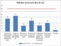
2.1.1.4. Extreme phenomena
During the years 2016-2020, Dak Lak province recorded many extreme phenomena occurring in the province such as: floods, droughts, thunderstorms, tornadoes and landslides (Table 2.2). These natural disasters caused great damage to people and property, greatly affecting the socio-economic development of the province (Appendix 4).
Table 2.2. Current status of natural disasters in Dak Lak province from 2016-2020
Year
Natural disaster | |||||
Storm | Flood, inundation | Drought | Tornado, thunderstorm | Landslide | |
2016 | - | 03 batches | 02 batches | 28 cases | - |
2017 | 01 attack | 03 batches | - | 17 cases | 3 cases |
2018 | - | 02 batches | 02 batches | 14 cases | - |
2019 | - | 03 batches | 02 batches | 08 cases | - |
2020 (as of October) | - | 03 batches | 01 batch | 16 cases | - |
Total | 1 attack | 13 batches | 7 batches | 83 cases | 3 cases |
Source: Department of Natural Resources and Environment of Dak Lak province
2.1.1.5. Environmental incidents
During the period 2016 - 2020, forest fires in Dak Lak province tended to increase in both quantity and damaged forest area (Table 2.3). Stemming from human carelessness, the weather became more severe and the temperature increased due to climate change, making the fires more serious. According to statistics from the Dak Lak Provincial Forest Protection Department, in the past 5 years, the province has had many forest fires causing damage to 69.69 hectares of forest area.
Table 2.3. Area of forest burned in the period 2016 - 2020
Year
2016 | 2017 | 2018 | 2019 | 2020 | |
Damaged forest area (ha) | 9.13 | 0 | 8.79 | 34.17 | 17.6 |
Source: Dak Lak Provincial Forest Protection Department
2.2.2. Causes of climate change in Dak Lak province
2.2.2.1. Pressure from population growth and urbanization
The population of Dak Lak province in 2015 was 1,820,149 people, by 2019 it reached 1,872,574 people, an increase of 52,425 people, the average annual population growth rate in the period 2015-2019 was 0.73% [11]. The increase in population will concentrate and increase the demand for resources such as water and energy, while also increasing the amount of waste generated beyond the natural environment's ability to decompose, polluting the air environment due to waste, exhaust gas, smoke and dust, ... this is a factor causing GHG emissions.
Population growth and urbanization also put pressure on natural resources and the land environment due to overexploitation of resources for housing needs, food production, industrial production, etc., causing forest areas to decline at a significant rate. According to statistical reports, in 2008, the total forest area was 628,977 hectares, with a coverage rate of 47.2%. By 2020, this number had decreased to 514,700 hectares, with the province's natural forest coverage rate remaining at just over 38% [47].
2.2.2.2. Pressure from industrial activities
Industrial production is strongly developed, the operation of too many means of transport has created a large amount of toxic waste into the environment (especially exhaust gas). In Dak Lak province, many different types of industries, even though these facilities have modern technology, all impact the environment, in different aspects and levels (surface water pollution, groundwater, air, dust, noise, traffic, ...) causing the surrounding areas to be affected. In addition, there are still production facilities located in residential areas, this is one of the sources of pollution that is difficult to control, easy to spread and directly affects people's health and the natural environment.
2.2.2.3. Pressure from construction activities
In the past, construction management in the province has been closely linked with environmental management. However, there are still activities such as transporting construction materials, constructing construction works without dust protection, handling construction waste, and domestic waste during construction, which are sources of impact affecting the air environment. The impacts of air pollution associated with this industry include dust, CO, SO 2 , NO x , H 2 S...
2.2.2.4. Pressure from energy activities
- Hydropower development activities:
Vietnam’s steady economic growth over the past two decades has led to an increasing demand for energy. Hydropower currently contributes about 35-40% of the country’s energy production. However, the rapid increase in the number of hydropower plants has given rise to environmental and social issues.
Hydropower requires a large amount of water from rivers and destroys river ecosystems. The operation of hydropower plants is accompanied by the problem of deforestation in the watershed. According to experts' calculations, on average, each hydropower project that is formed will have 125 hectares of forest cleared [11]. Deforestation causes higher temperatures and more severe climate change. Currently, according to statistics from the Department of Industry and Trade of Dak Lak province, 19 medium and small hydropower plants have been built in Dak Lak province (Appendix 5a).
- Solar power development activities:
Waste from production and solar panels after their life cycle, such as sulfuric acid and phosphine gas, if leaked to the outside, will cause unpredictable harm. To date, there is almost no method to reduce the problem of toxic waste from solar panels. Reusing these materials is extremely difficult and solar panels often have a very short life cycle. According to current statistics, there are 6 solar power plants in operation in Dak Lak province. In addition, Dak Lak province has submitted to the Prime Minister and the Ministry of Industry and Trade to supplement the power development plan for 23 solar power projects on land (Appendix 5b).
2.2.2.5. Pressure from Agriculture, Forestry and Fishery Activities
In the process of developing agriculture, forestry and fishery, the habit of using pesticides, chemical fertilizers and the situation of indiscriminately dumping used packaging is a huge pressure, causing pollution of the soil, water and air. In addition, the activities of craft villages and small-scale industrial establishments contribute to increasing environmental pollution because waste during operation is not treated. Due to low investment capital, establishments have not invested in technological innovation and environmental protection.
2.2.2.6. Pressure from medical activities
Medical waste can contain pathogenic microorganisms and heavy metals. The risk of air pollution is increased because most hazardous waste is burned in non-ideal conditions, causing a lot of black smoke. Burning medical waste in plastic bags along with certain pharmaceuticals can create acid gases and even dioxin, an extremely toxic chemical even at low concentrations. In addition, heavy metals such as mercury can also be released into the exhaust gas of the incinerator, posing a risk to the environment, the ecosystem and human health in the long term.
2.2.2.7. Pressure on tourism, service, business, trade and import-export activities
Tourism activities increase the amount of domestic waste such as solid waste, wastewater, increasing the risk of soil pollution, water pollution, besides increasing the risk of air pollution, noise due to increased means of transport and large crowds. Tourism activities also increase pressure on land funds due to the construction of hotels, service facilities, at the same time the construction process also creates a large amount of waste causing environmental pollution.
2.2.3. Impact of climate change in Dak Lak province
Climate change increases the volatility and intensity of extreme weather events, causing great impacts on socio-economic development and many serious damages to all sectors and fields, greatly affecting the province's sustainable development goals. According to statistics, the total value of damage caused by natural disasters in the past 5 years has been more than 3,700 billion VND.
2.2.3.1. Impact of climate change on agriculture
Agricultural production in the period 2016-2020 was affected and damaged by storms, floods, droughts, and tornadoes with 252,407 hectares of various crops, of which 24,539 hectares of crops were completely lost; Climate change also caused many difficulties for the livestock industry, causing many epidemics, reducing the number of livestock individuals, 31,806 livestock and poultry of all kinds died due to epidemics and were swept away; 173.7 hectares of aquaculture ponds were flooded and swept away.
Annual rainfall is distributed less in the dry season. Therefore, there is a sharp shortage of water in the dry season, causing the depletion of lakes and dams that store water for agricultural activities. In addition, floods and droughts have severely affected the quality and caused serious degradation of some irrigation works such as landslides and concrete collapses, reducing the ability to store water for the dry season.
2.2.3.2. Impact of climate change on forestry
The most serious impacts of climate change on forest ecosystems in Dak Lak province are the increase in frequency, intensity, volatility and extremity of dangerous weather phenomena such as storms and tornadoes causing damage to forest areas (in 2017, storm No. 12 caused damage to 10,295.09 hectares of forest, estimated damage to planted forests of 167,786 billion VND and property damage of 103 million VND) [11], higher temperatures, increased duration and intensity of drought will increase the risk of forest fires (Table 2.3), hot and dry weather, floods causing inundation or drought, cold damage, and pests and diseases reduce the biomass productivity of forest trees, leading to a reduction in the ability to absorb CO2 and other toxic gases (greenhouse gases).
2.2.3.3. Impact of climate change on transport and infrastructure
In the context of climate change, the quality, lifespan and service capacity of traffic routes and other infrastructure (information, communication, electricity) are significantly reduced. In 2016, about 20 km of various types of roads were damaged; about 8 km of irrigation works were eroded; in addition, 02 headquarters were damaged and 115 houses were flooded. In 2017, 38 km of roads (provincial, district, communal), many rural roads, 02 solid traffic bridges, 90 km of irrigation canals, 27 key irrigation works were severely damaged, 09 irrigation sluices and many dams, temporary dams and bridges were eroded. In 2019, 3 reservoirs were flooded, damaged and eroded; more than 63 km of canals were flooded and eroded; 1.5 km of dike was eroded (of which 15 m of dike was broken); 2.4 km of national highway, more than 56 km of local roads were eroded [11].
2.2.3.4. Impact of climate change on water resources
Climate change is one of the causes that directly affects the quality and quantity of water resources. High rainfall in the rainy season and steep terrain carry suspended solids, reducing water quality. Drought reduces water reserves, combined with the increased demand for water exploitation from groundwater sources, increasing the permeability of pollutants such as organic matter,
fertilizers, microorganisms. Therefore, the quality of groundwater is increasingly declining significantly.
2.2.3.5. Impact of climate change on land resources
Climate change has had a clear negative impact on soil quality. Prolonged drought in the dry season makes the structure of the surface soil layer susceptible to changes in the direction of infertileness, the risk of desertification due to heat and low humidity. Floods and rains mainly concentrate in September-December every year with heavy rainfall sometimes reaching nearly 400mm/month, creating concentrated surface flows that increase the risk of landslides. In 2017, there were 3 major landslides: landslide on the bank of the Krong No River in Ea Rbin Commune, Lak District; landslide on the bank of the Krong Bong River in Village 4, Hoa Phong Commune, Krong Bong District; landslide on Pass 185 in Ea Trang Commune, M'Drak District [11].
2.2.3.6. Impact of climate change on health and people
Climate change causes increased temperature and humidity, creating conditions for pathogens to easily develop and increase, such as malaria, dengue fever, plague, cholera, etc., which significantly impact vulnerable groups such as children, the elderly, the sick, people with poor sanitation conditions, and people living in areas at risk of flooding. Floods cause fertilizers, pesticides, toilet waste, livestock barns, etc. to be washed into ponds, lakes, rivers, and streams, leading to the risk of outbreaks of gastrointestinal diseases and other diseases spread by water sources, including animal diseases, diseases with natural outbreaks, diseases from other places, etc., which increases the cost of disease prevention and treatment for people and the health sector. Climate change is also one of the causes of the emergence of a number of new infectious diseases (nCov, diphtheria, etc.), accelerating the mutation process of disease-causing viruses; causing serious impacts on people's health and socio-economic development.
According to the report of the Center for Disease Control, Dak Lak Provincial Department of Health, in Dak Lak province, the number of people suffering from diseases such as dengue fever, measles, hand, foot and mouth disease, malaria, diarrhea, and seasonal flu is very large (Table 2.4).
Table 2.4. Summary of the number of cases in Dak Lak province from 2016-2019
TT
Disease name | 2016 | 2017 | 2018 | 2019 | Total | |
1 | Dengue fever | 11,896 | 2.221 | 1.135 | 23,048 | 39,375 |
2 | Malaria | 32 | 371 | 717 | 523 | 1,755 |
3 | Seasonal flu | 21 | 14,642 | 13,761 | 13,121 | 50,321 |
4 | Diarrhea | 32 | 11,945 | 11,049 | 8,878 | 37,638 |
5 | Measles | 2 | 0 | 55 | 2,435 | 2,537 |
6 | Hand, foot and mouth disease | 362 | 1,892 | 1.122 | 1,277 | 5,792 |
Source: Dak Lak Provincial Center for Disease Control
2.2.3.7. Impact of climate change on biodiversity
Climate change with consequences such as floods, droughts, forest fires, erosion and landslides will promote faster and more severe degradation of diversity, especially in intact tropical forest ecosystems, increasing the risk of extinction of animals, plants and rare genetic resources. The construction of many irrigation ponds and lakes, irrigation works affects the migration of some aquatic species, some irrigation works completely eliminate migration routes, degrade and destroy natural habitats, invade alien species, compete with and destroy native species.
2.3. Current status of climate change response of local authorities in Dak Lak province
2.3.1. Work on developing and promulgating policies to respond to climate change
Dak Lak Provincial People's Committee regularly pays attention to and directs relevant units, departments and branches throughout the province to seriously implement policies and laws in response to climate change. Specifically, the Provincial People's Committee has implemented Decision No. 158/QD-TTg dated December 2, 2008 of the Prime Minister on promulgating the National Target Program to Respond to Climate Change; Decision No. 1183/QD-TTg dated August 30, 2012 of the Prime Minister on implementing the National Target Program to Respond to Climate Change for the 2010-2015 period; Official Dispatch No. 3815/BTNMT-KTTVBDKH dated October 13, 2009 of the Ministry of Natural Resources and Environment on the direction of developing an action plan to respond to climate change; Resolution No. 24-NQ/TW of the 11th Party Central Committee on proactively responding to climate change, strengthening resource management and environmental protection