Coliform content is many times higher than QCVN 10:2008/BTNMT, Coliform content ranges from 7000 - 9000 MNP/ 100 ml, 7 - 9 times higher than the standard
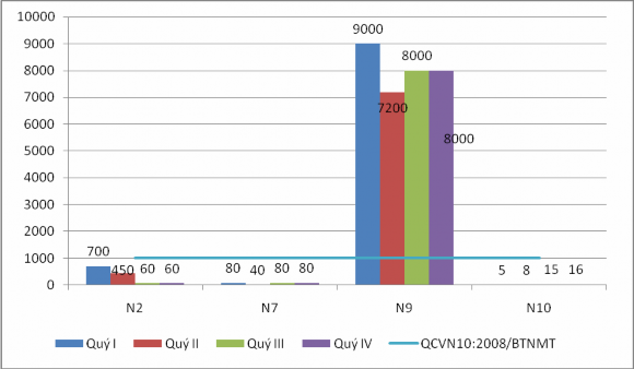
Figure 1.9: Coliform content in some coastal seawater samples
6. Oil content in seawater
- Impact of production wastewater on the grease content in the water environment of Cua Luc Bay: In general, the results of wastewater environmental monitoring of some production facilities show that the total mineral grease content meets QCVN 40:2011/BTNMT for industrial wastewater and there are no signs of pollution. In 6 monitoring locations, point N8 - Wastewater of Ha Khanh Wastewater Treatment Plant has the highest grease content, only reaching 0.39 mg/l, followed by monitoring point N1 - Ha Khau Wastewater Treatment Plant with a content of 0.32 mg/l (quarter II).
Table 1.16: Wastewater monitoring results of some production facilities around Cua Luc Bay
STT
Monitoring location | Grease (mg/l) | ||||
Quarter I | Quarter II | Quarter III | Quarter IV | ||
1 | N1 | 0.28 | 0.2 | 0.23 | 0.32 |
2 | N3 | 0.01 | 0.02 | 0.01 | 0.01 |
3 | N4 | 0.15 | 0.21 | 0.34 | 0.29 |
4 | N5 | 0.1 | 0.21 | 0.3 | 0.25 |
5 | N8 | 0.1 | 0.21 | 0.39 | 0.25 |
QCVN 40:2011/BTNMT – B | |||||
Maybe you are interested!
-
 Controlling coastal seawater pollution in Ha Long city, current situation and solutions - 13
 -
 Content of Implementation of Legal Policy on Management of Education Sector Officials
 -
 Xrd Diagrams Of Hydrothermal Tfg20 Samples At Different Temperatures
 -
 Defense organization and protection activities of the central coastal region under the Nguyen Dynasty in the period 1802 - 1885 - 25
 -
 Research on current status and improvement of cropping system on coastal land of Thanh Hoa province - 19
(Source: Periodic environmental monitoring report)
- For coastal seawater: ¾ of the monitored samples showed signs of pollution. In which, monitoring point N10 - Cua Luc Bay - Bai Chay Bridge had a content of up to 0.871 mg/l (quarter III/2012), followed by Lang Khanh port - N9 with an oil content exceeding 3 - 4 times QCVN 10:2008/BTNMT.
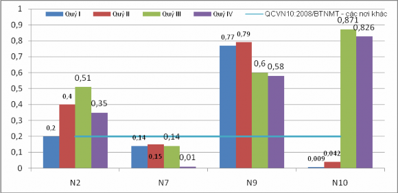
Figure 1.10: Oil and grease content in some coastal seawater samples
In summary, the monitoring results show that at all monitoring points, the pH, COD, As, and Cd values are within the allowable limits according to QCVN; there are no signs of pollution. For industrial wastewater: at point N5 - Concentrated livestock and poultry slaughterhouse in Ha Khanh ward, there are signs of Pb and Coliform pollution. For water
Coastal sea: At point N9 - Coastal seawater of Lang Khanh port has TSS, Pb, Mn, Coliform, and grease content exceeding the permissible limit; At point N7 - Between the drainage channel of Ha Khanh and the export system of Ha Long Cement factory: TSS, Pb, and Mn content exceeding the permissible limit; Point N2 - Water passing through K67 Cao Xanh bridge has Pb, Fe, and grease content exceeding the permissible limit; Point N10 - Bai Chay bridge has grease content exceeding the permissible limit
CHAPTER 2. LOCATION, TIME, METHODOLOGY AND RESEARCH METHODS
2.1. Analysis of location, geographical position and natural conditions affecting water pollution in Cua Luc Bay.
2.1.1. Location, geographical location
Cua Luc Bay is located in the North of Ha Long City, occupying the lowest, frequently flooded area of Cua Luc Bay basin. To the North, Cua Luc Bay borders Thong Nhat Commune, Le Loi Commune, Hoanh Bo District; to the West, it borders Ha Khau Ward, Gieng Day Ward, Viet Hung Ward, Ha Long City; to the East, it borders Ha Khanh Ward, Cao Xanh Ward, Ha Long City; to the South, it borders Bai Chay Ward and Ha Long Bay (Figure 2.1).
Due to its low location and its outlet (bay strait) connecting to Ha Long Bay, Cua Luc Bay plays an important role in regulating the hydrological and oceanographic regime of rivers before flowing into Ha Long Bay. Waste flowing into Cua Luc Bay from surrounding or internal activities in the bay will be partially decomposed, partially deposited, and partially transported out of the bay. This explains why the water environment of Cua Luc Bay still has many indicators within the allowable limits.
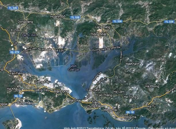
Figure 2.1. Geographical location of Cua Luc Bay and vicinity on remote sensing images
2.1.2. Natural conditions
1. Geology
The geological foundation that makes up the Cua Luc Bay basin includes formations ranging in age from Ordovician to Quaternary, mainly sedimentary and extrusive rocks. [8]
- The Carboniferous - Permian formations have three formations: Cat Ba, Bac Son and Bai Chay formations: The study area is located in the Bai Chay Formation (P 2 bc) distributed in a narrow strip on the hills on both sides of Cua Luc.
- The Mesozoic sediments in the basin have a total thickness of about 8000m, including the Na Khuat Formation (T 2 nk ) which forms the mountain ranges at the watershed in the north of the basin, the upper reaches of the Troi River and Vu Oai River (the western branch of the Dien Vong River); the Hon Gai Formation (T 3 n - r hg) is distributed on low mountain ranges around Cua Luc Bay, containing many coal seams.
- Cenozoic formations are mainly distributed in and around Cua Luc Bay, including Miocene to modern sediments. Belonging to Neogene are the Dong Ho Formation (N 1 dyad) and Tieu Giao Formation (N 2 tg). The Dong Ho Formation is distributed on low hills on the edge of Cua Luc Bay from Gieng Day through Hoanh Bo.
- Pleistocene formations are distributed on low hill ranges around Cua Luc Bay with formations of fluvial origin consisting mainly of coarse-grained materials such as pebbles and boulders and formations of marine origin with the main component being yellow-gray silty sand.
- Holocene formations are distributed in low-lying terrain around and within Cua Luc Bay .
The geological formations north of Highway 18B (Upper Ordovician - Silurian and Carboniferous - Permian) have a solid structure, weak weathering ability, high coarse grain ratio and are less affected by the system of tectonic faults, creating a solid foundation of quite stable landscapes, with little generation of washed materials.
The formations south of Highway 18B and around Cua Luc Bay (Mesozoic and Neogene) have a less solid structure, a thick weathering layer with many fine particles (silt, clay), strongly influenced by the system of tectonic faults, forming complex destruction zones, especially the coal-bearing formations in the east of Cua Luc Bay (Hon Gai Formation (T 3 n - r hg)). Therefore, when there are impacts from economic and mining activities, the solid foundation of the landscapes is often easily broken, generating a large amount of fine materials, which can be washed down to Cua Luc Bay.
2. Terrain features
Located on the coastal zone of Quang Ninh province, Cua Luc Bay basin has a funnel shape with a large bottom edge extending along the sub-latitude direction. The terrain is radial towards the bottom of Cua Luc Bay. The slope from North to South is many times greater than the slope from East and West. [9]
The terrain has a stratified elevation that decreases from North to South. The watershed of the basin lies on mountain ranges with an elevation of 800 - 1000m (the highest peak is Am Vap with an elevation of 1090m), moving down to an elevation of 400 - 600m, to 200 - 300m and then to a low mountain range with an elevation of less than 200m around Cua Luc Bay. The mountain ranges in the North of the basin are the cloud-blocking walls, creating
Prolonged heavy rains upstream brought large floods that swept away a lot of material from mining areas and landslides downstream.
In the East and West of Cua Luc Bay, there are high hills and low mountains with directions that are not consistent with the general structure of the terrain. In the West of the bay is the Chua Loi mountain range with a height of 500 - 600m, stretching in the Northwest - Southeast direction. In the East is the Giap Khau mountain range (where valuable coal mines are concentrated) with a height of 200 - 300m, stretching in the Northeast - Southwest direction. The extension direction of these mountain ranges is consistent with the direction of the geological structure on the sedimentary rocks of the Hong Gai formation and creates the unique shape of Cua Luc Bay.
In the basin, there are four flat surface levels existing at different heights: 800 - 1000m, 400 - 600m, 200 - 300m and 80 - 100m. Three high surfaces exist as remnants with small areas on the tops of the northern mountain ranges. The 80 - 100m surface has a wider distribution area, currently being affected by erosion and washout to create slopes of 5 - 12 0 .
* The main terrain types of Cua Luc Bay include:
- Mountainous terrain with an altitude of 600 - 1000m is mainly distributed in the North of the basin (accounting for 10% of the natural area). Low mountain terrain with an altitude of 200 - 500m. Eroded hill terrain has an altitude of about 30 - 200m (but is common at an altitude of 100 - 150m) with an area of about 45km2 . Valley terrain accounts for 8% of the total area of the region. Alluvial plain terrain along the bay is mainly distributed around Cua Luc Bay.
+ The tidal flat terrain is distributed around Cua Luc Bay, flooded according to the ebb and flow of the tide, suitable for the development of mangrove forests.
Tidal flats are modern formations common along the coast of Cua Luc Bay. The source of alluvium is mainly weathering products washed down from the mountainous areas around the bay. On the northern shore, the tidal flats are wider and longer. The structure of the tidal flats is silty sediments, silty sand and gray to dark gray clay. Tidal currents are the main driving force for redistributing materials to create tidal flats. Due to their unstable nature, tidal flats are easily changed in shape by strong tidal currents, especially during the rainy season. During this period, erosion often occurs strongly at the tail of the flats.
Tidal, eroded material is carried by tidal currents, causing new banks and beaches to appear in places with favorable conditions downstream.
- The terrain of Cua Luc Bay area, based on the morphology and elevation of the tidal flats, can be divided into low tidal flats and high tidal flats [10]:
+ High tide flats: limited in the altitude range from average sea level to highest sea level (2.06 - 4.7 m/0mHĐ), widely distributed in Cua Luc Bay; characterized by a drying time of 12 - 14 hours/day. On the surface, many mangrove plants grow.
+ Low-tide flats: limited in height from lowest sea level to average sea level (2.06 m/0mHĐ); dried daily for 10 - 12 hours but not the entire flat. On the surface, there is a complete absence of mangrove vegetation.
+ Tidal erosion: Large tidal amplitude (4 - 4.7 m) and cyclical fluctuations in water level are the main driving forces creating tidal currents in the bay, creating tidal erosion. Based on the depth of the erosion activity of the tidal current, tidal erosion is divided into 2 groups:
Surface tidal intrusive creeks: operate in the elevation range of the tidal flats (from 4.7 m to 0 mHĐ), develop in the high tidal zone and divide them into many separate pieces.
Inherited subtidal erosional creek group: distributed at the bottom of the bay and places where the seabed is narrowed by two islands (Hon Gac area). At Cua Luc, the narrowest place is also where the tidal current is strongest, reaching a maximum depth of over 20m. This creek group is inherited from tectonic valleys and erosional valleys before the sea advance period. The group consists of 5 levels, corresponding to the basic erosional depth levels: 1.5 - 2 m, 3 - 5 m, 11 - 12 m and 18 - 20 m. Due to the accumulation of the seabed, many places in this group have been filled up with interrupted depths such as at the Man River mouth and some small river mouths have been blocked.
3. Climate
The climate regime of the study area has the characteristics of the Northeast coastal climate and is influenced by the monsoon regime (humid tropical monsoon climate), with relatively cold winters, short dry periods, and high annual rainfall .