3.2.3.2. Medical
There is 01 district hospital and 15 commune health stations. The communes have infirmaries to examine and treat people and have done a good job of disease prevention and family planning.
3.2.3.3. Culture
The ethnic groups have a rich and diverse cultural and spiritual life. Each ethnic group has its own traditional cultural features such as: Hat coi of the Tay ethnic group; Hat phuong of the Nung and Giay ethnic groups; Hat giao duyen of the Mong and Dao ethnic groups. Besides the cultural beauties, the district also has major festivals such as: Long Tong festival of the Tay ethnic group and Gau Tao festival of the Mong ethnic group held in the spring; Lang Hai festival also known as the moon calling ceremony of the Tay people held in the middle of the eighth lunar month every year; longevity celebration of the Tay and Xuong ethnic groups...
3.2.3.4. Infrastructure
Up to now, the whole district has asphalt and concrete roads to the commune center. Village and hamlet roads have also been invested in by the people and the state. Most of the villages have concrete and dirt roads that cars can travel on, the rest have motorbike roads to the village and hamlet centers. The state has also invested in public works serving the community: schools, classrooms; hospitals, medical stations; commune People's Committee headquarters, cultural houses, etc. The national grid has been extended to the commune center and villages. Thanks to the development of infrastructure construction, it has contributed significantly to the development of this mountainous district. Especially in the production of goods and poverty reduction.
3.3. General comments and assessments on basic conditions of the research area
3.3.1. Advantages
- There is a diversity of tree species and favorable temperature and humidity complex suitable for forest planting.
- Receive financial support from the State in building a protective forest system.
- People have a tradition of agricultural and forestry production, attached to the forest.
3.3.2. Difficulties
-The geographical location of Yen Minh district is a mountainous district in the North, so the transportation of goods and attracting domestic and foreign investment capital are still limited.
- The terrain in forested areas is often complex and strongly fragmented, so the work of planting, caring for and protecting protective forests still faces many difficulties.
- The people's educational level is still low, so the absorption of scientific and technical advances to serve forest construction and economic development is still slow.
- The benefits from planting, caring for and protecting protective forests are very low compared to the labor that people put in. This leads to people not being enthusiastic about developing protective forests in the locality.
- The socio-economic infrastructure has been improved but is still generally weak. Traffic in some villages is still dirt roads, causing difficulties in traveling (especially in the rainy season from April to October). The number of ethnic households still lacking clean water, electricity for daily life, housing difficulties, lack of production land... requires continued investment in the coming period.
Chapter 4
RESEARCH RESULTS
4.1. Current status of protective forest planting in Yen Minh district, Ha Giang province
4.1.1. Area and site conditions for protective forest planting
a, Area of protective forest planting
According to the plan, the area of protective forests to be planted in the period 2011 - 2015 in Yen Minh district is 1,590.3 hectares.
As of 2015, the total area of protective forests planted in Yen Minh district was 4,147.2 hectares, specifically shown in the following table:
Table 4.1: Area of protective forests planted over the years in the district
STT
Year of implementation | Area (ha) | Rate (%) | |
1 | 2011 | 862.2 | 20.8 |
2 | 2012 | 951.5 | 22.9 |
3 | 2013 | 1,418.3 | 34.2 |
4 | 2014 | 528.5 | 12.7 |
5 | 2015 | 386.7 | 9.3 |
Total | 4,147.2 | 100 | |
Maybe you are interested!
-

 General Assessment of the Current Situation of Public Investment Capital Management at the Ministry of Health in the Period 2016 - 2020
 -
 General Assessment of Factors Affecting Tourism Development in Vientiane City
 -
 General Assessment of the Content of the Composition Course
 -
 General Comments on the Significance of Khmer Culture in Tourism Exploitation in Kien Giang Province
 -
 General Assessment of Beliefs in Traditional Tet
(Yen Minh District Forest Protection Management Board - 2015 Summary Report)
The area of planted protective forests is shown in the following chart:
Area (ha)
1600
1400
1200
1000
800
600
400
200
0
951.5
862.2
1418.3
528.5
386.7
Acreage
2011 2012 2013 2014 2015 2011
Chart 4.1: Area of protective forests planted over the years in the district
Through table 4.1 and chart 4.1, it can be seen that: The area of protective forests planted in the district was the highest in 2013 (with an area of 1,418.3 ha) and the lowest in 2015 (with an area of 386.7 ha). It shows that in the first years, the area was planted with an increasing area until 2013, then gradually decreased. Protective forest planting was carried out on 4,147.2 ha/1,590.3 ha, reaching 260.8% of the project plan. The result of protective forest planting has created an annual increase in coverage. Coverage reached 31.2% in 2011 to 35.1% in 2015.
b, Site conditions for protective forest planting
Site conditions of the forest plantation include factors that have profound and long-term effects throughout the life of the plant such as: soil, vegetation, slope, etc. The above factors are closely related to each other, with a changing factor affecting one or more other factors. Therefore, site conditions are the initial factor that directly affects the results of forest plantation in general and protective forest plantation in particular.
- Land for protective forest planting: In the same climate conditions, land has a great influence on the yield, area and quality of crops. Therefore, the division of land according to the level of importance to show the importance in choosing a place to plant protective forests. Through the research results, the results of classification into 3 levels according to the level of importance (very important, important, less important) to serve the planting of protective forests in the district are summarized in the following table:
Table 4.2: Classification of critical levels for protective forest planting in the district
STT
Total | Area (ha) | Rate (%) | |
1 | Level I | 360.8 | 8.7 |
2 | Level II | 3541.7 | 85.4 |
3 | Level III | 244.7 | 5.9 |
Total | 4147.2 | 100 | |
(Ha Giang Provincial Forestry Department)
Note: Level I is a very vulnerable area; Level II is a vulnerable area; Level III is a less vulnerable area.
The results of the classification of critical levels for protective forest planting are shown in the following chart:
Critical level
Chart 4.2: Classification of critical levels for protective forest planting
Through table 4.2 and chart 4.2, it can be seen that the district has paid attention to selecting the area for protective forest planting. Protective forest planting is mainly focused on planting at level II (accounting for 85.4%), then level I (accounting for 8.7%) and at least level III (accounting for 5.9%). In which, the protective forest planting area mainly has rainfall from 1,500 - 2,000mm, the land level for protective forest planting is mainly light loam, medium loam, topsoil depth 30 - 40cm, root ratio of about 25%, mixed rocks about 20%. Suitable for protective forest planting.
- Land cover for protective forest planting: Land cover (vegetation) is a group of plants covering the ground like a green carpet. In the technical measures of forest planting, the work of treating the land cover is very important in creating favorable conditions for plants to grow and develop well. Therefore, it is necessary to pay attention to the study of what type of land cover is in the plot of land prepared for forest planting. The study helps in finding the most effective method of treating the land cover. The results of classifying the land cover for protective forest planting in the district are summarized in the following table:
Table 4.3: Classification of vegetation for protective forest planting in the district
STT
Total | Area (ha) | Rate (%) | |
1 | Phytoderma group I | 899.9 | 21.7 |
2 | Phytoderma group II | 3247.3 | 78.3 |
Total | 4147.2 | 100.0 | |
(Technical design documents for protective forest planting - Forestry Department)
The results of the classification of protective forest vegetation levels are shown in the following chart:
Area (ha)
3247.3
899.9
3500.0
3000.0
2500.0
2000.0
Epidermis
1500.0
1000.0
500.0
0.0
Epidermis group I Epidermis group II
Phytoderma group
Chart 4.3: Classification of vegetation levels for protective forest planting
Through table 4.3 and chart 4.3, it can be seen that: The vegetation for planting protective forests in the district is mainly concentrated in vegetation group II (accounting for 78.3%) and vegetation group I (accounting for 21.7%). The main vegetation level for planting protective forests is cogon grass, reeds, and scattered, low coverage, mixed with sedge and mulberry, which are scattered. It is not favorable for vegetation treatment, which has a significant impact on forest planting.
- Slope affects protective forest planting: Slope is a factor that affects forest planting techniques. The greater the slope, the more difficult it is to plant forests. Slope classification also contributes significantly to the analysis and correct application of forest planting techniques. The results of slope classification for protective forest planting in the district are summarized in the following table:
Table 4.4: Slope of protective forest planting in the district
STT
Slope (degrees) | Area (ha) | Rate (%) | |
1 | < 15 | 483.6 | 11.7 |
2 | 15 - 25 | 3170.8 | 76.5 |
3 | > 25 | 492.8 | 11.9 |
Total | 4147.2 | 100.0 | |
(Technical design documents for protective forest planting - Forestry Department)
The results of classifying the slope of protective forest planting are shown in the following chart:
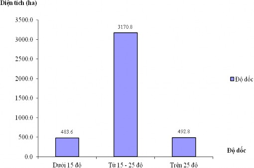
Chart 4.4: Slope of protective forest planting
Through table 4.4 and chart 4.4 shows:
The slope of the protective forest planting area in the district is mainly concentrated at the slope of 15 - 25 0 (accounting for 76.3%), followed by the slope above 25 0 (accounting for 11.9%) and the slope below 15 0 (accounting for 11.7%). The conditions of the protective forest planting area are difficult due to the high slope of the land area. This is also one of the reasons why trees cannot grow and develop well.
- The direction of forest planting slopes is distributed in all different directions. However, the main concentration is in the Southeast and Southwest directions. This is the direction with the most advantages for the growth and development of forest trees because the forest trees are regularly illuminated every day.
*General comments:
- The site conditions in the area are suitable for protective forestation. Average slope (15 0 - 25 0 ), vegetation cover group II, Southeast and Southwest slope direction, average rainfall 1,500 - 2000mm, light loam soil group , medium loam, topsoil depth 30 - 40cm, root ratio about 25%, mixed rock about 20%.
- According to the regulations on slope classification, the slope classification for planting protective forests in Yen Minh district has been implemented in accordance with the regulations. However, this is a limiting factor for tree growth. Because in this terrain, in addition to the harsh soil and climate factors, inadequate human care, the trees also suffer from a serious lack of water.
4.1.2. Structure of tree species planted in protective forests
- The species of seedlings planted for protection forests in the district are selected from the following groups of tree species: Pine, Sa Moc, Trau, So... (depending on natural conditions: Land, climate, weather, actual conditions of the protective forest planting location in the neighboring area, the forest planting needs of contracted households, organizations, and individuals).
- These tree species are characterized by being easily adaptable to harsh climates. The species of trees: Trầu, Sở are species that provide very effective non-timber forest products; the seeds of these trees contain 50-70% oil, have high export value; usually after 6 years they will be harvested.
- The results of synthesizing the proportion of tree species participating in protective forest planting through area (ha) and vulnerable areas are shown in the following table: