Figure 3.26. Chloride content evolution of layer qp 2 in dry season 60
Figure 3.27. Chloride content evolution of layer qp 2 during the rainy season 60
Figure 3.28. Iron content evolution of aquifer qp 1 dry season 61
Figure 3.29. Iron content evolution of aquifer qp 1 rainy season 62
Figure 3.30. Nitrate content variation of qp 1 aquifer in dry season 62
Figure 3.31. Nitrate content variation of qp 1 aquifer in rainy season 63
Figure 3.32. Chlorine content evolution of aquifer qp 1 dry season 63
Figure 3.33. Chlorine content evolution of aquifer qp 1 rainy season 64
Figure 3.34. Nagaoka 82 large diameter water collection well technology
INTRODUCTION
Hanoi City is the political, economic, cultural and social center of the whole country, one of the areas located in the center of the Red River Delta and the key economic region of the Northern Delta. Here, a large population is concentrated with the highest population density in the country. The strong development of industrial, agricultural and service sectors has a great demand for water for drinking, daily life and production.
However, the rapid urbanization in Hanoi has drastically changed environmental conditions in general and groundwater resources in particular. The decline of groundwater resources (pollution, depletion) has occurred in some places, affecting the lives of people and economic sectors in the city. In the central area of the inner city, due to the impact of strong water exploitation for decades, combined with the unreasonable arrangement of water exploitation wells far from the recharge source, it has led to the formation of a funnel lowering the water level with a large area of hundreds of square kilometers, contributing to promoting negative impacts on the environment such as depletion of water resources, increased groundwater pollution, ground subsidence, etc.
The inner city area of Hanoi has a high population density of about 12,000 people/km2 , so the amount of water supplied for daily life and production is very large. Currently, the water supply for Hanoi includes about 800,000m3 / day, water is exploited from groundwater at large factories (excluding single exploitation, exploitation in rural areas) and about 300,000m3/day taken from surface water. The groundwater source of Hanoi is increasingly declining in both quantity and quality. The decline in quantity is most clearly manifested in the decline in exploitation capacity at well fields in the inner city area and the decrease in groundwater level over time, the expansion of the funnel lowering the groundwater level. Groundwater in the Hanoi area is manifested in the contamination of some elements in some areas. The most obvious manifestation is the contamination of nitrogen compounds, specifically ammonium in the southern area of the city, where there are well fields in Ha Dinh and Phap Van. The reasons for this situation are due to urbanization, increasing demand for water, and the management of groundwater exploitation is not yet strict. From the above issues, it shows that there is a need for comprehensive research on groundwater degradation, for rational and sustainable use.
Groundwater resources. The topic " Assessing the current status of groundwater resources in the inner city of Hanoi " is set out with the aim of assessing the current status of water quality, exploitation status and the level of groundwater degradation in the inner city of Hanoi. On that basis, propose a number of solutions for the sustainable management and use of groundwater resources in the inner city of Hanoi.
CHAPTER 1. OVERVIEW OF THE RESEARCH PROBLEM
1.1. Overview of the situation of exploitation, use and degradation of groundwater resources in the world and Vietnam
1.1.1. Concept of groundwater
Groundwater is water contained in underground water layers [12]. Groundwater is a form of underground water, stored in loose sedimentary rock layers such as sediment, gravel, sand, silt, in cracks, and karst caves under the earth's surface, which can be exploited for human activities. According to the distribution depth, groundwater can be divided into surface groundwater and deep groundwater. The common characteristic of groundwater is the ability to move quickly in porous soil layers, forming underground flows according to the terrain. Surface groundwater often has no separating layer from the surface terrain. Therefore, the composition and water level vary a lot, depending on the state of the surface water. Surface groundwater is very susceptible to pollution. Deep groundwater is often located in porous rock layers separated above and below by impermeable layers. According to the distribution space, a deep groundwater layer often has 3 functional zones: water intake zone, water transmission zone, and pressurized water exploitation zone.
Most groundwater forms in a branch of the water cycle along with other hydrological factors. There are four ways to form groundwater. Atmospheric origin: due to rainwater, surface water in rivers, lakes, swamps, etc. seeping into the layers of soil and rock below when these layers have high porosity zones. Most groundwater is of this type. Sedimentary origin: when deposited, it is in the form of wet mud. The subsequent sedimentation process creates an overlay layer, causing the rock to compress and the water to separate into a layer. The water layers at the bottom of oil and gas mines are of this type. Magmatic origin (Primary): when magma cools, crystallization occurs, the excess hydrogen and oxygen, if any, will separate and combine into water. The source of water from magma has decreased a lot, because the Earth's solid crust is now thicker, and hydrogen is a light element so it is less retained in the Earth's core. Metamorphic origin (Secondary): Intrusive activities heat the soil and rock, causing metamorphism of the sedimentary layers above, leading to the discharge of water from the sediment [24].
An aquifer is a geological formation of soil and rock that is permeable enough for water to be contained and moved within it and from which an economically significant amount of water can be extracted from surface sources, or from artificial structures such as wells and boreholes.
Very poor water geological formations are geological formations with very low water absorption and permeability, not enough to produce an economically significant amount of water from natural sources or from artificial structures such as wells and boreholes. In classification, they are often classified as aquifers.
Non-aqueous geological formations are geological formations that are not capable of absorbing or permeating water. Soil and rock have a permeability coefficient of less than 10 -9 m/s. In the stratigraphic section, these formations play the role of a water-proof layer.
Porous aquifers are aquifers in which water is stored and moves within the pores between soil and rock particles.
Fissured aquifers are aquifers in which water is stored and circulated in fractures, crevices or karst caves.
Based on the water-holding capacity, geological formations are divided into two main types: water-bearing layers and non-water-bearing layers. The specific water-rich level is divided in Table 1.1:
Table 1.1. Classification of water richness of aquifers
Water richness
Flow rate (l/ms) | Point flow road (l/s) | |
Very rich | q > 3 | Q > 5 |
Rich | 1 < q ≤ 3 | 0.5 < Q ≤ 5 |
Medium | 0.2 < q ≤ 1 | 0.1 < Q ≤ 0.5 |
Poor | 0.05 < q ≤ 0.2 | Q ≤ 0.1 |
Maybe you are interested!
-

 Assessment of the Current Status of the Policy on Developing Female Human Resources in the People's Public Security Force
 -
 Assessment of the Current Status of Access to Bank Credit Capital of Small and Medium Enterprises in Thai Nguyen Area in the Period of 2013 - 2018
 -
 Assessment of the current status of compensation, support and resettlement when the state acquires land in some projects in Hong Bang district, Hai Phong city - 1
 -
 Assessment of the Current Status of IT Application Investment Project Management at the Department of Information Technology and Customs Statistics
 -
 Assessment of the current status of wastewater environment of Gieng Vuong market, Hoang Van Thu ward, Lang Son city, Lang Son province - 4
1.1.2. Situation of exploitation, use and degradation of groundwater resources in the world
The total amount of water on earth is about 1,357.5 million km3 of water [42], the current state of global water is shown in Figure 1.1, of which only 3% is fresh water, the remaining 97% is salt water in the oceans. Of the 3% of total fresh water on earth, up to 77% exists in the form of permanent ice (ice blocks in the arctic, south poles).
The remaining 1% of water contained in rivers and lakes across continents and 11% of underground water at depths of 800m or less can be exploited for use, while the remaining 11% of underground water at depths below 800m cannot be exploited for use under current technical conditions.
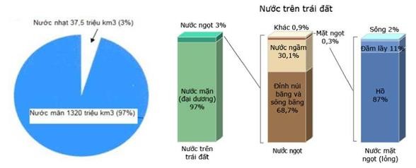
Figure 1.1. Global water situation [42]
The countries with the largest water extraction are India, the United States, China, Pakistan and Iran. Every year, the United States exploits and uses 569.45 billion m3 , of which groundwater accounts for 1/4. The most intense groundwater extraction occurs in the states of California, Texas and Nebraska.
In general, the exploitation and use of water resources in the world is increasing rapidly while water resources are limited. The consequence has been the decline and increase in the depletion of water resources. The map shows the sustainability of groundwater exploitation in Figure 1.2. The map was established by Dutch hydrogeologists in 2006 and gave an index with a value of <20%, indicating that the territory still has abundant groundwater and can be exploited sustainably. Countries with an index of 100% and higher are located in the Middle East and North Africa, where groundwater is gradually being depleted. Countries with an index from 20% to 100% are countries where groundwater exploitation can only be sustainable if water exploitation is strictly controlled and there is a plan to artificially replenish groundwater. Vietnam is among the countries with an average index.
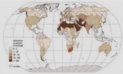
Figure 1.2. Map showing sustainability in groundwater exploitation
However, the areas with stable groundwater resources in the world are shrinking day by day. There are three main problems affecting the use of groundwater: depletion due to overuse, improper exploitation planning and flooding, salinization due to unreasonable exploitation and continuous ineffective use, and pollution caused by agricultural, industrial and other human activities.
In Henan Province, the largest province in northern China with an area of 2 million hectares, water from dug wells was used to irrigate 52% of the arable land. Water level testing data from 358 wells in an area of 75,000 km2 showed that water levels had dropped by between 0.75 m and 3.68 m between 1975 and 1987. In Changzhou County of Hebei Province, where 76,800 wells irrigated 0.29 million hectares - equivalent to 37% of the arable land - the area was covered by saltwater, and the saltwater ratio increased by 9.1% between 1980 and 1990. In the Fuyang River Basin in northern China, the National Water Resources Management Institute (IWMI) studied the formation of basins, and the surface water supply for agriculture has been severely reduced over the past 20 years due to the need to meet water needs for industry. People have increased the exploitation of groundwater for irrigation, with the number of dug wells in the basins increasing by about
91,000 wells in the 2000s, resulting in a drop in groundwater levels of 8 to 50 m from 1967 to 2000 [46]. About 300 medium and large cities in
China, with its dense population and dependence on groundwater, faces severe water shortages and is pessimistic about its water needs. IWMI researchers in Guanajuato province, one of Mexico's most agriculturally developed regions, found that water levels in 10 aquifers studied have declined at an average annual rate of 1.79 m to 3.3 m/year in recent years [45]. Aquifers in the Fuyang River basin are under pressure from two sides: people are increasingly depleting groundwater resources downstream and industry is polluting groundwater resources upstream.
The World Bank recently reported that groundwater overexploitation is considered a major threat to the well-being of the people of Yemen [46]. In the highlands, for example, water consumption is estimated to exceed potential by up to 400%. In recent times, in West Asia, Southwest Asia, the Indian subcontinent and Pakistan, more boreholes have been built each year for irrigation, and groundwater use has outpaced replenishment over large areas. This process has been rapid in places, with serious consequences. The consequences of overexploitation of groundwater in the three Indian regions of Punjab, Haryana and Western Rajasthan have been salinization of groundwater. In Northern Gujarat and Southern Rajasthan, groundwater has been contaminated with fluoride. In Southern India, a decline in borehole flow in hard rock formations has occurred due to competition for increased well depth. In coastal areas, the most serious consequence of over-exploitation of groundwater is the intrusion of salt water further inland.
Unplanned groundwater exploitation can destroy vulnerable ecosystems, such as wetlands, oases in Africa and Asia. Azraq Oasis - the heart of the Jordanian Badia is a typical example of over-exploitation of groundwater [44]. Azrag Wetland in Ramsar with an area of over 7500 ha is home to many terrestrial and aquatic species, indigenous species, unique species and species in large numbers. This oasis has been praised by the world as a great refuge for migratory birds and is one of the attractions